An Inventory of the Historical Monuments in the County of Cambridgeshire, Volume 1, West Cambridgshire. Originally published by Her Majesty's Stationery Office, London, 1968.
This free content was digitised by double rekeying. All rights reserved.
'Tadlow', in An Inventory of the Historical Monuments in the County of Cambridgeshire, Volume 1, West Cambridgshire( London, 1968), British History Online https://www.british-history.ac.uk/rchme/cambs/vol1/pp203-207 [accessed 27 July 2024].
'Tadlow', in An Inventory of the Historical Monuments in the County of Cambridgeshire, Volume 1, West Cambridgshire( London, 1968), British History Online, accessed July 27, 2024, https://www.british-history.ac.uk/rchme/cambs/vol1/pp203-207.
"Tadlow". An Inventory of the Historical Monuments in the County of Cambridgeshire, Volume 1, West Cambridgshire. (London, 1968), , British History Online. Web. 27 July 2024. https://www.british-history.ac.uk/rchme/cambs/vol1/pp203-207.
In this section
35 TADLOW
(O.S. 6 ins. aTL 25 S.E., bTL 24 N.E.)
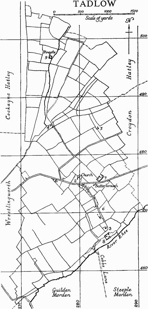
The village and parish of Tadlow, the latter an irregular N. and S. segment containing 1688 acres, lie immediately N. of the river Rhee, here flowing S.W. to N.E. at about 90 ft. above O.D. The W. boundary with Bedfordshire, 3 m. long, is straight abutting Cockayne Hatley, but its S. half towards Wrestlingworth follows the edges of old fields, as do the N. and E. boundaries for the most part. The fields over most of the parish are arranged approximately in rows parallel to the river. Church and churchyard (Monument (1)) are incorrectly orientated but range with these fields; the village street system (see Monument (6)) appears to do the same. The name may mean 'Tada's tumulus'.
In the N. of the parish, beyond the line N.G. TL 272482 and 285488, the field pattern changes; here the land rises to over 200 ft. This end of Tadlow was formerly the independent settlement of Pincote, first mentioned in the late 12th century (Reaney, 'Placenames of Cambs.', 66; see Monument (9)). An early 13th-century reference indicates that there were then only two open fields (see Monument (10) Cultivation remains).
The older house sites in Tadlow seem, as at East Hatley (Hatley (18)), to have been moated and to have been arranged along the street already alluded to; this last turns S.W. as it approaches the river to cross it at Tadlow bridge, whence a minor road called Cobb's Lane runs almost due S. to the Mordens.
Tadlow
The village of Tadlow has now almost ceased to exist, and there are scarcely any secular monuments above the ground. The highway from Cambridge to Biggleswade, made c. 1826, now divides the church and vicarage from the few remaining houses; prior to that a through road from the E. met the village street at about N.G. TL 283471 (Baker's map of 1821).
Tadlow Towers (Monument (5); Plate 120), the scene, c. 1745, of an attack on the last Sir George Downing by 'a villainous Fellow' working on the site (B.M. Add. MS. 5820, 49), was a group of buildings of some interest, recently demolished.
Ecclesiastical
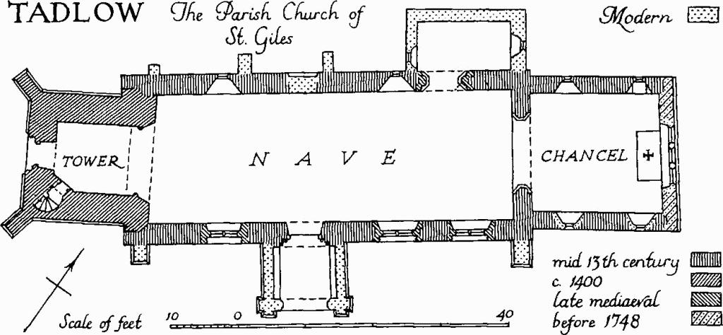
Tadlow, the Parish Church of St. Giles
b(1) Parish Church of St. Giles stands on a spur of the chalk ridge at the N. end of the village. The churchyard, which has been extended on the S., and the church itself which is orientated some 35° N. of E., range with the field boundaries in the S. half of the parish. The church was given to the Canons Regular of St. Giles, Cambridge, by Picot the sheriff at the end of the 11th century and passed, though apparently not without dispute, with other endowments to the priory of Barnwell (Liber Memorandorum Ecclesie de Bernewelle, ed. J. W. Clark (1907), 40, etc.). The fabric, consisting of Chancel, aisleless Nave, and West Tower, is of fieldstones and clunch with dressings of freestone and clunch; the roofs are tiled. The chancel and nave are of the mid 13th century. A tower was added c. 1400 to a partly corrected orientation, and subsequently the S. side of the nave was refenestrated. At some unknown date prior to 1748 the chancel was shortened (B.M. Add. MS. 5820, 46). There was a restoration supervised by W. Butterfield in 1860.
Architectural Description—The Chancel (19 ft. by 17½ ft.) has E. wall, rebuilt before 1748, with three modern graded lancets. There are two lancets in either side wall: those on the N. are original externally, but those on the S. are modern. The 13th-century chancel arch is of three chamfered orders with a label on either side; the responds are stop-chamfered and have attached part-octagonal shafts with moulded caps and chamfered bases; the whole has probably been rebuilt.
The Nave (52¼ ft. N. and 54 ft. S. by 19 ft.) has a restored late mediaeval arch towards the E. end of the N. wall, of two chamfered orders with a label to the N.; the outer order is continuous, the inner is carried on attached part-octagonal shafts with moulded caps and bases; some of the chamfered faces are slightly hollowed or sunk. Above and to the E. of this arch, which now leads into a modern organ chamber, visible from the nave, is the rear arch of a blocked lancet. Two further lancets, W. of the arch, are complete but their splays and rear arches have been restored; they are of tall and narrow proportion. Between the second and third lancet is a blocked N. doorway, with continuous chamfered jambs and head and moulded label. The windows and doorway are original. In the S. wall of the nave are three late mediaeval windows, each of three cinque-foiled lights with vertical tracery in depressed four-centred heads; they are uniform except for a transom in the tracery of the first window. Between the second and third windows is the original S. doorway which is of three orders with a modern label; the outermost order is accommodated in an extra thickness of wall, the junction with the main face being concealed by the side walls of the rebuilt porch; the chamfered innermost order has a moulded impost at the springing, the remainder are moulded, and are carried on restored nook shafts in the jambs with mutilated caps and modern bases.
The West Tower (10¾ ft. by 10 ft.), though out of alignment, has its E. wall approximately on the site of the former W. wall of the nave, the W. buttresses of which survive. It is in three stages with a plain parapet and has a W. doorway with four-centred inner and square outer head, a label and panelled spandrels. Immediately above this doorway is a window of two cinque-foiled lights with a quatrefoil in a four-centred head and a label. Also in the W. wall, in the second stage, is a small loop light, and there is a quatrefoil light in the E. wall looking into the nave. The bell chamber has a restored window in each face, of two cinque-foiled lights in a four-centred head with a label. The tower arch is of three orders to the E. and two to the W.; the two outermost orders to the E. are moulded, the remainder chamfered; on the W. the outer order dies against the side walls. The responds are deeply splayed to the E. and have attached part-circular shafts carrying the inmost order with moulded caps and bases. The stair is entered by a doorway with depressed four-centred head canted across the S.W. corner.
Fittings—Bell: 3rd of three inscribed in black-letter 'Sancte Andrie Ora Pro Nobis', late mediaeval. Churchyard cross: plain base only, limestone, 1 ft. 8 ins. square with square socket for shaft, mediaeval; said to have come from Church Farm, where it had been built into the farmhouse. Door: to tower stair, of overlapping planks, nail-studded, 16th- or 17th-century. Glass: a few late mediaeval fragments in tracery lights of second window on S. side of nave. Monuments and Floor slabs. Floor slab: in nave, white limestone much worn, with remains of incised female figure and marginal inscription, traces of bitumen filling; it is that of Margaret, wife of William Brogriffe, 1493 (B.M. Add. MS. 5820, 46–7; the six children at the feet of the principal figure, mentioned by Cole, have been almost, if not entirely, effaced). Plate: includes an inscribed cup by Thomas Buttell, c. 1570; and paten with London marks for 1844. Scratchings: include, on N. respond of chancel arch 'i h c' and on S. respond 'i h c' twice and a cross, all upside down; on N. jamb of W. door 'Anno dn~i mcccccxvij' and, beneath it, a name, not read. Miscellaneous: a quantity of stonework loose in the churchyard, immediately W. of the approach path from the S., includes fragments with sub-classical mouldings, 16th- or 17th-century; these were brought here in 1906 from a house at Clopton, demolished in the previous year.
Secular
b(2) Vicarage (Class U), now alienated, set in a small landscape garden occupying high ground to the S.W. of the church; erected by Downing College 1832–3 at a price of about £1300 to plans provided by the bursar (Downing College Proceedings in muniments).
The house is two-storeyed and of white brick with hipped slated roofs. The three bays of the S. front have each, on the ground floor, a sash window with low sill, giving access from the drawing room and study to the garden. The front door is in a shallow central recess on the W. side and has a semicircular fanlight with central roundel flanked by drooping lobes. Extensive offices to the N. have been curtailed and modernised.
b(3) Bridge Farm, buildings include a thatched barn of 3½ aisled bays and a rectangular tiled structure which may have been a granary; both are framed and boarded, and of the 17th or 18th centuries.
b(4) New England Farm, buildings include two barns to the E. of the modern house which incorporate timber framing of the 17th or 18th century.
b(5) Tadlow Towers (Plate 120) consisted of an 18th-century prospect tower in red brick of four storeys, an internal-chimney dwelling of the 17th or 18th century, and a 16th-century granary (Plate 36) of plank-and-muntin construction with hipped tiled roof divided into three bays by tie-beam trusses. All were derelict and have recently been demolished.
Earthworks
b(6) Village Remains (not on O.S.). The earlier plan of Tadlow, on gault clay with a gentle slope S.E. to the Rhee, had houses and closes on either side of a dog-legged street. Church and manor house were at the N. end of the village. As at East Hatley (Hatley (18)) the former closes and house sites were bounded by wet ditches. The remains consist of a hollow-way and four groups of enclosures:
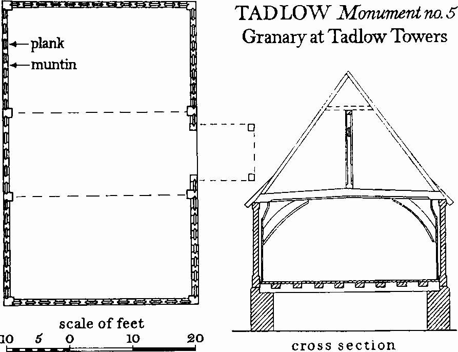
Tadlow, Monument No. 5, Granary at Tadlow Towers
(a) Hollow-way originally leading N.E. from the present village street at about N.G. TL 28174742 to a moated site (Monument (7)), 600 ft. long, 50 ft. wide and 2 ft. deep. The actual junction with the present street cannot be traced, and the main road has destroyed part at the N.E. end.
(b) adjoining the foregoing on the S.W. and S. of the main road are two contiguous ditched enclosures (N.G. TL 282475, partly on O.S.). The N.E. one measures 100 ft. N.E. to S.W. by 76 ft., and is surrounded by a wet ditch 20 ft. to 30 ft. wide and 1 ft. to 1½ ft. deep except on the N.E. where the main road has cut across it. The S.W. enclosure, 60 ft. N.E. to S.W. by 30 ft., is limited by a ditch 15 ft. to 30 ft. wide and 1½ ft. to 2 ft. deep. The interiors of both enclosures are flat, and both are in pasture.
(c) at N.G. TL 28254715, in a field called 'Orchard Close' in 1750 (maps in Downing College), a ditch, running parallel to the present street and 140 ft. to the S.W. of it, forms the S.W. boundary of an enclosure. Towards the N.W. end, where best preserved, it is 35 ft. wide and 30 ft. deep. 13th- to 19th-century pottery and building debris occur in the ploughed interior.
(d) on the W. side of the present street, between N.G. TL 283470 and 283468 are a series of six very disturbed ditched enclosures. They vary in size from 60 ft. by 80 ft. to 40 ft. by 140 ft. and are bounded by ditches 10 ft. to 25 ft. wide, widened at one point to form a pond up to 50 ft. wide.
(e) on the E. side of the present street around N.G. TL 284469 are three disturbed and irregular enclosures 60 ft. to 80 ft. E. to W. and respectively 170 ft., 60 ft. and 250 ft. N. to S. They are bounded on the E. by a W. scarp 3 ft. high and defined on the N. and S. by irregular ditches 8 ft. to 25 ft. wide and 6 ins. to 2 ft. deep.
b(7) Moated Site (Class A1 (b): N.G. TL 283476); on flat gault clay at the foot of a gentle slope to the S. It is that of the manor house of Tadlow or Hobbledods (W. Rye, C.A.S., 8vo Publs. XXVI (1891), 74, 79, etc.). In 1840 the field to the S. was known as Batterborough (tithe map). The ditches are overgrown and part of the interior is planted with trees.
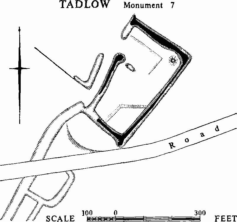
Tadlow, Monument 7
A trapezoidal area 330 ft. N.W., by 205 ft. N.E., by 340 ft. S.E., by 130 ft. S.W., is enclosed by a wet ditch 25 ft. to 33 ft. wide, 3 ft. to 5½ ft. deep, and 12 ft. to 15 ft. wide across the bottom; it is filled by a stream entering at the N. angle and flowing out at the S. angle. The entrance seems to have been in the N.W. side. On the 1750 maps (in Downing College) a lane ran N.E. from the present village street, ending near the N.W. side, and its line, a continuation of the hollow-way described under Monument (6(a)), is represented by a hollowway 32 ft. wide and 1½ ft. to 2 ft. deep which now runs into the W. angle of the moat. Originally the lane ran between the N.W. side and a length of ditch 160 ft. long, 25 ft. wide and 2 ft. deep, parallel to the moat ditch at a distance of 30 ft.; this ditch has an arm projecting N.W. for 50 ft. at the S.W. end, probably an inlet channel. There is a staggered entrance now 50 ft. wide in the N.W. side of the moat, 100 ft. from the N. angle, and on either side the ditch has cupped ends with the S.W. length set back 30 ft. from the line of the N.E. length.
Inside the moat there is a roughly rectangular depression 6 ins. to 1 ft deep to the S.E. of the entrance with disturbances on the S.E. where a building stood in 1901. In the E. corner there is a circular mound 20 ft. across and 2 ft. high, and in the S. corner there is a raised area 100 ft. across and 1 ft. to 1½ ft. high. Outside the S.W. side of the moat is a platform 120 ft. long and 80 ft. wide at the N. end, bounded on the S.W. by a curving scarp 4 ft. high; this scarp was probably made during the construction of the present road in 1826. The ditched enclosure S. of the road, see Monument (6 (b)), does not seem to be connected with the moat.
b(8) Moated Site (N.G. TL 285466), at Bridge Farm, 70 yds. N. of the river Rhee. A wet ditch 263 ft. long, 30 ft. wide and 5 ft. deep which runs along the S.E. side of the farm seems to be the remaining S. side of a moat, since at its S.W. end it widens to 40 ft. as if turning N., and a projection N. for 62 ft. at the N.E. end may indicate an E. side. The whole site is however much disturbed by the farmyard, and the ditches are overgrown. To the S.W. a dry ditch continues the line of the S.E. side for 300 ft. and to the N.E. a slight wet ditch runs on. Two ditches branching from this last run N.W. for 92 ft.; the first is 380 ft. and the second 456 ft. N.E. of the supposed E. angle. A cottage stands on the plot so defined.
b(9) Moated Site (Class A1(a)) and Settlement Remains (N.G. TL 275497; moat only on O.S.) in a broad open valley in the boulder clay. The area is under plough. Both are survivals of the small settlement of Pincote, a separate manor treated in mediaeval documents as distinct from Tadlow (W. Rye, C.A.S. 8vo Publs. XXVI (1891), 36, 46; Public Record Office, Calendar of Inquisitions Post Mortem, 1 (1904), 60; Early Chancery Proceedings, V (1912), 170; VII (1963), 165).
The Moated site consists of a rectangle 110 ft. N. to S. by 100 ft. bounded by a wet ditch 25 ft. to 35 ft. wide and 3 ft. to 5 ft. deep. The W. side continues N. for 100 ft. and terminates in a cupped end. The N. side has been partly filled and there is now no trace of the channel, shown on the 1750 maps at Downing College, continuing the S. side to join the stream. Slight mounds 50 ft. across and 9 ins. to 1½ ft. high at the S.W. and N.W. angles are the only features within the treecovered interior of the moat. A triangular pond 12 ft. to the E. of the E. side was shown as rectangular in 1750; it now measures 125 ft. from N. to S. and 50 ft. E. to W. with a channel to the stream near the N.E. corner.
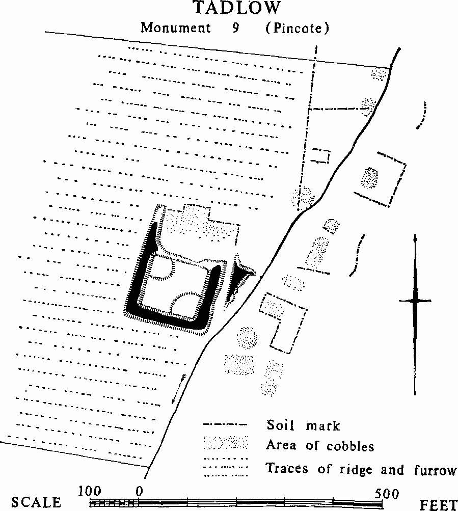
Tadlow, Monument 9 (Pincote)
The Settlement remains are to the N. and N.E. and E. of the moat, where much late 12th- to 17th-century pottery occurs, 13th-century predominating; in the same area there are patches of cobbles and tiles including 14th-century ridge tiles with a slip pattern. Traces of what appear to be buildings can be seen on vertical air photographs.
(10) Cultivation Remains (not on O.S.). Ridge and furrow with ridges 60 yds. to 170 yds. long, 7 yds. to 9 yds. wide and 9 ins. to 1 ft. high, with headlands of 5 yds. to 8 yds., remains around the village. At about N.G. TL 277475 a large field, called 'Great Cow Pasture' in 1750, has been cut by the later road and split into smaller fields; 27 straight ridges remain in the middle of the former large field. The remains in the S. of the village around N.G. TL 282469 were formerly divided into five closes by ditches 10 ft. wide and 9 ins. deep.
The traces of ridge and furrow visible on air photographs over most of the N. of the parish are straight or slightly curved, and fit the existing field boundaries except along the stream. This parish apparently had two open fields in 1220 and these appear to have survived until the mid 17th century (M. A. Postgate, 'The Open Fields of Cambridgeshire' (unpublished thesis, Cambridge, 1964), 17 and 269), but the extents of these cannot now be established. By 1750 the entire parish was enclosed.
(Ref: maps of 1750 (Downing College); tithe map, 1840; W. E. Tate, C.A.S. Procs. XL (1944), 46; air photographs: CPE/UK/2024/3105–7, 3085–8, 4102–7.)