An Inventory of the Historical Monuments in the County of Cambridgeshire, Volume 1, West Cambridgshire. Originally published by Her Majesty's Stationery Office, London, 1968.
This free content was digitised by double rekeying. All rights reserved.
'Croydon', in An Inventory of the Historical Monuments in the County of Cambridgeshire, Volume 1, West Cambridgshire(London, 1968), British History Online https://www.british-history.ac.uk/rchme/cambs/vol1/pp71-79 [accessed 30 April 2025].
'Croydon', in An Inventory of the Historical Monuments in the County of Cambridgeshire, Volume 1, West Cambridgshire(London, 1968), British History Online, accessed April 30, 2025, https://www.british-history.ac.uk/rchme/cambs/vol1/pp71-79.
"Croydon". An Inventory of the Historical Monuments in the County of Cambridgeshire, Volume 1, West Cambridgshire. (London, 1968), British History Online. Web. 30 April 2025. https://www.british-history.ac.uk/rchme/cambs/vol1/pp71-79.
In this section
13 CROYDON
(O.S. 6 ins. aTL 25 S.E., bTL 35 S.W., cTL 24 N.E., dTL 34 N.W.)
The parishes of Croydon and Clopton (sometimes called Clapton), united in 1561 (W. M. Palmer, 'A History of Clopton, Cambridgeshire', C.A.S. Procs. XXXIII (1933), 37), occupy a triangular area of 2734 acres of which the river Rhee forms the S. side. The boundary between the two seems to have run from N.G. TL 30125032 S.S.E. along the line of a modern plantation to about 30674906 and thence in a S. to S.E. curve E. of Rouses Wood to the river; the land, which rises to 265 ft. towards the N. apex varies from boulder clay at that point through chalk and gault. The chalk scarp crossing the parish from E.N.E. to W.S.W. is a prominent and historically decisive feature: the village of Croydon originally occupied a recession into this scarp caused by a number of strong springs which no doubt attracted primary settlement (remains on the site are described under Monument (8)); that of Clopton, now deserted (Monument (15)), was very similarly sited about a mile to the W.S.W.
Clopton, a Domesday vill, had a market in the 13th century but seems to have declined during the later middle ages; it was reckoned with Hatley for some purposes by the 15th century, and was finally depopulated and enclosed by John Fisher between 1500 and 1518 (W. M. Palmer, op. cit., 30).
The present small village of Croydon is strung out W.S.W. of the church along a secondary road at the foot of the scarp. This road was realigned in the first half of the 19th century but its old course slightly to the N. is traceable at a number of points between N.G. TL 31254928 and the school at 31484945; it equates with the trackway (g) described as part of Monument (8). In any case this street development is comparatively modern; in the 18th century there was a number of dwellings on 'Croydon Lane' connecting the W. end of the present street to the high road to the S; while to the N. an irregular field of some 17 acres between the village remains and the manor house site (Monument (11)) was still called the 'Green'.
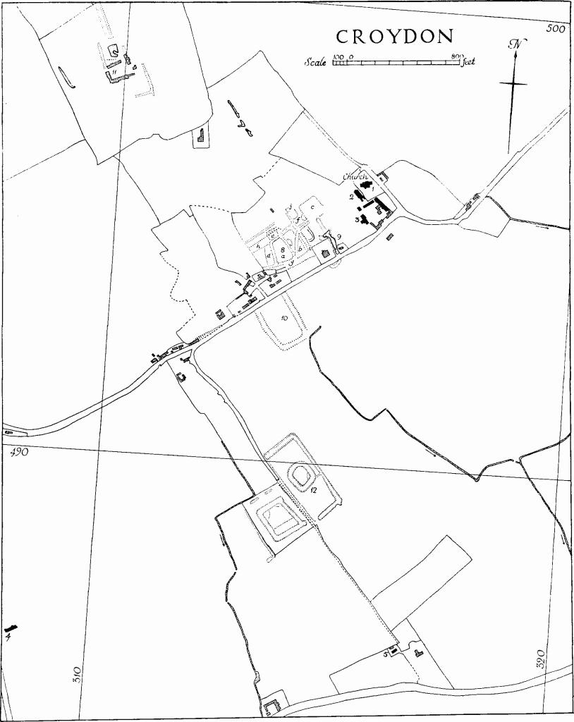
Croydon
In addition to the remains of the two villages there is an unusual number of moated sites, some of which can be equated with known manors. Croydon Wilds (Monument (7)), a 17th-century 'mansion', perhaps a hunting lodge, set within its garden moat (Monument (14)), was destroyed comparatively recently.
From the later decades of the 17th century until the middle of the 18th century much of Croydon formed part of the Downing family's extensive estate; much of the remainder belonged to the Gapes of Caxton and St. Albans. Mid 18th-century surveys made for both families survive at Downing College and in the Country Record Office. At this period there was some improvement of farms and cottages (e.g. Monument (4)), and the second Sir George Downing may be assumed to have rebuilt the chancel of the church.
The turnpike road from Cambridge to Biggleswade was made in 1826 and a small toll house (Monument (6)) is of that time, but most of the buildings along it were erected or rebuilt later in the century. For the rest the small 18th- and 19th-century houses in the parish are of poor quality.
Ecclesiastical
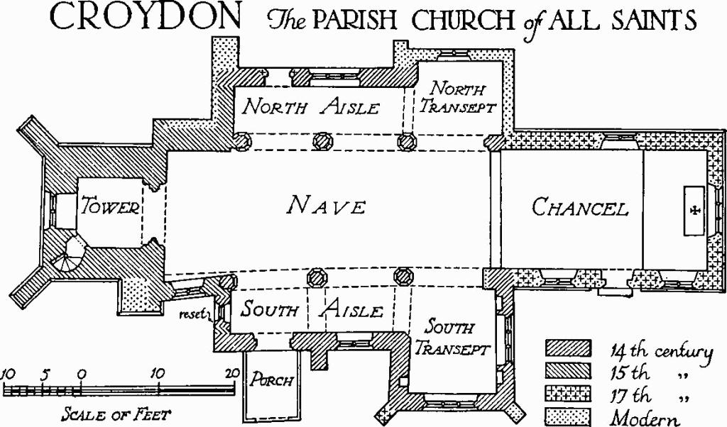
d(1) Parish Church of All Saints stands at the N.E. end of the modern village on a raised four-sided platform which slopes gently to the S. and E. The position is towards the top of the scarp slope on high ground. The site is an unstable one and there has been much piecemeal rebuilding consequent on subsidence. The fabric consists of Chancel, Nave with Aisles and transeptal Chapels, and West Tower. The walls are of field stones, clunch and brick, with clunch and freestone dressings; the roofs are tiled.
The 12th-century bowl of the font suggests a church of that time but the earliest identifiable part of the structure is the S. arcade of c. 1300. In the 14th century the N. arcade and both aisles with their chapels were built or rebuilt. The tower was intruded into the W. end of the fabric in the late 14th or 15th century. The chancel was rebuilt, probably by the second Sir George Downing, c.1685 and remodelled in 1867. The church was restored in 1937. The fittings are of little interest and, save perhaps for Monument (3) below, there are no traces of memorials to the Downing family.
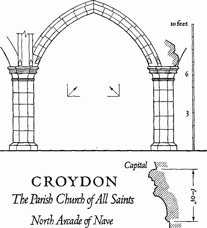
Architectural Description—The Chancel (27¼ ft. by 15½ ft.), of red brick with freestone dressings, has a chamfered plinth and the N. and S. walls are finished with a moulded cornice. Its S. doorway and four windows, some at least of which replace original features, are 19th-century. There is no chancel arch. The Nave (44 ft. by 15¼ ft. E. to 17 ft. W.) has arcades of three bays each with octagonal piers and somewhat depressed arches of two chamfered orders. The piers of the 14th-century N. arcade have moulded caps and chamfered bases; the arches have broach stops. The E. respond is of two chamfered orders continuous with the first arch; to the W. a fourth arch, the E. springer of which is exposed, has been blocked, the third pier acting as W. respond to the shortened arcade. The S. arcade is of c. 1300 and has also been shortened, the outer order of the blocked W. arch, which is narrower than the others, being exposed on the N. side; the piers have moulded caps and bases and there are head stops to the N. above the first and second piers. In the blocking of the W. arch is a late 14th- or 15th-century window, of two cinque-foiled lights in a pierced four-centred head.
Croydon, the Parish Church of All Saints
The North Aisle (6 ft. wide) and North Chapel (11½ ft. by 9¾ ft.) are of 14th-century origin but the E. and N. walls of the chapel, which has probably been reduced in size, have been rebuilt. The N. doorway and adjacent window are of the 14th century. The doorway, of two continuous orders, originally of clunch, has been restored in brick, and the square-headed window of three trefoiled lights has a modern lintel. A butting arch across the aisle at its junction with the chapel, of two broach-stopped chamfered orders, appears to be coeval with the N. arcade. Externally the aisle walls have been extensively patched in brick and two brick buttresses have been added.
Croydon, the Parish Church of All Saints
North Arcade of Nave
The South Aisle (6 ft. wide) and South Chapel (11½ft. by 14 ft.) are 14th-century, restored and partly rebuilt. Two square-headed windows in the chapel, each of three cinque-foiled lights, and two others in the S. and W. walls of the aisle, respectively of two lights and one light, are original though in part restored; that in the W. wall is reset. The S. doorway, also probably original, is of two continuous chamfered orders, the inner plain, the outer with a bracket moulding in the head which dies away at the springing. A butting arch spans the aisle at its junction with the chapel; it and a parallel arch built against the arcade wall above the second pier are presumably 14th-century. The buttresses of the S. aisle and S. chapel are of brick and the walls of both have been patched in the same material. The South Porch, of wood, rendered externally and internally, is 17th-century.
The West Tower (8½ ft. by 9 ft.), of three stages, has a moulded plinth and restored diagonal W. buttresses; a third original buttress at the E. end of the S. wall has been strengthened in brick. The embattled parapet was removed in 1937 save for a small portion at the N.W. angle. The W. window, of two cinque-foiled lights with a quatrefoil in a four-centred head, is original. The dissimilar belfry windows are for the most part badly eroded: those to the S. and W. are of two trefoiled lights with a quatrefoil in the head; that to the E. of a single light; that to the N., square-headed and of two lights, is presumably a replacement. The tower arch is of two orders: the outer, with double-ogee and casement mouldings, is con tinuous; the inner is chamfered and is carried on part-circular attached shafts with moulded caps and bases. The vice in the S. W angle has original doorways at the foot and head of the stair, both with a single continuous chamfer.
The Roof of the chancel, divided into three bays by collar beams with ogee braces, is late 17th-century; that of the nave, of wagon form, ceiled, with added tie beams, may be mediaeval.
Fittings— Bell: by J. Briant of Hertford, 1786. Bell frame: with three pits, old. Door: at foot of vice, of two planks with strap hinges; late mediaeval. Font: rectangular limestone bowl with double rolls at the angles and plain bands at top and bottom; 12th-century; the bowl, which stands on a modern base, is fractured and has been filled to take a later lead lining. Monuments: In chancel—at E. end of N. wall, (1) small marble square inscribed 'AEH 1831'; at W. end of S. wall (2) of Rev. William Ackworth Love, 1836, curate of the parish. In S. gable of S. transept (3) a blank shield, a date panel and a third, inscribed, stone, all possibly fragments of a 17th-century monument. Niches: a pair, flanking E. window of S. chapel, with moulded jambs and cinque-foiled heads; 14th-century. Painting: traces, of uncertain date, over the second pier of the N. arcade on both sides. Piscina: in S. chapel, at E. end of S. wall, with moulded jambs and cinque-foiled ogee head, rectangular drain; 14th-century. Plate: includes a paten, London 1709, a chalice, London 1841, both inscribed and presented in 1842; a pewter dish with Norwich mark, a cup and a flagon, late 17th- or 18th-century. Pulpit: composed of panels and other woodwork from the former, 17th-century, pulpit, in a 19th-century gothic frame. Recess: in S. chapel, at S. end of W. wall, small, rectangular. Weather-vane: the tower is surmounted by a jewelled wooden finial supporting an iron post terminating in a crown; 17th-century, decayed.
Secular
d(2) Rectory, of white brick with tiled and slated hipped roofs, of two storeys and attics, is of the early 19th century. The house is planned in double depth and is entered at the N. end. The principal, garden, elevation is to the W., in four bays with glazed doors on the ground floor and hung sashes over. Some interior detail, including the staircase, is original.
d(3) Church Farm comprises a house and buildings. The House is an L-shaped structure of two storeys and attics with a range to the N. of a single storey and attics; it is framed and plastered, with some red brick, and is of the 17th century. The gable-ended roofs are slated. The Buildings, arranged around a yard to the E., include two 17th- or 18th-century framed barns, of three and five bays, and a small 17th-century granary. The granary, framed and boarded, with pantiled roof is now carried on later brick piers; its door, to the E., opens on to a central gangway flanked by tie-beam trusses.
d(4) Range, originally of one larger and two smaller dwellings, late 17th- or 18th-century, is of one storey and attics, with red brick front; the framed ends and back have been partially replaced in later brick. The front, which is semisymmetrically designed, is divided into four bays by brick pilasters two of which flank the entry to a central through passage, now partly built up; the ground-floor doors and windows are segmental-headed and there are four gabled dormers.
d(5) House (Class J), single-storeyed with attic, framed and plastered, with tiled gable-ended roof; late 17th- or 18th-century.
d(6) Toll house (N.G. TL 31424842), single-storeyed, of white brick with slated roofs; c. 1826.
b(7) Croydon Wilds (N.G. TL 30405148), house, demolished in or about 1957, stood within the garden moat (Monument (14)) described below; it was the 'mansion house on the Wylde', otherwise 'Croydon Tower', first mentioned in 1647, when it belonged to Sir Anthony Cage (C.R.O.).
The derelict building (Plate 120) recently standing, of brick with tiled roofs, was little more than the N.E. half of an E-shaped house known from the plans of a mid 18th-century surveyor (C.R.O.). It contained work of several 17th-century phases, the earliest of which was probably Jacobean. Surviving details included a number of windows with brick mullions, a stair with ovolo-moulded newel posts and turned balusters, and a number of'pigeon holes' made of clay bat.
Earthworks
d(8) Village remains (N.G. TL 313495–314495, not on O.S.). The site is at the bottom of a steep S.E. slope and at the mouth of a valley cutting back into the chalk escarpment on the line of junction between chalk marl and gault clay. The valley is presumably the original 'crows' dene' which gave its name to the village (Reaney, 'Place-names of Cambs.', 53).
The principal remains are three roughly rectangular enclosures, all disturbed.
(a) of ⅓ acre, is bounded by ditches 5 ft. to 15 ft. wide and up to 4 ft. deep.
(b) over ½ acre, is defined by broad banks 2 ft. high, by low scarps and by the N.E. ditch of (a).
(c) is marked by scarps up to 1½ ft. high.
(d), (e) and (f) are platforms with scarps up to 2 ft. high.
(g), (h) and (i) are trackways. (g), a terrace up to 40 ft. wide between scarps 1 ft. high is probably the earlier line of the village street parallel to it. (h) and (i), the latter slightly hollowed, coincide with footpaths.
(j) is a bricklined pit 25 ft. square and 7 ft. deep, marked as a 'bath' in 1750 (Downing estate maps 1750, in Downing College).
d(9) Moated site (N.G. TL 315494, part only on O.S.), 170 yds. S.W. of the church on the junction of the chalk marl and gault clay. The remains appear to be those of two oblong enclosures, placed in line on a N.W. and S.E. axis, and consist of the N.W. half of the long N.E. side and the S.E. end. The complex was comparatively complete when planned in the mid 18th century (Downing estate maps 1750, in Downing College); it was then known as Holpotts.
The surviving part of the long side consists of a wet ditch 300 ft. long with projecting arms about mid way, to the S.W. 60 ft. long and to the N.E. 15 ft. long. The ditch is 30 ft. across (20 ft. at water level), widening to 50 ft. in the S.E. half; and 4 ft. to 6 ft. deep. On the S. side of the village street, a shallow dry ditch 60 ft. long is the supposed S.E. side; returns at either end have been cut by the street.
d(10) Enclosure (N.G. TL 314493, not on O.S.), rectangular and dry-ditched, immediately S. of the E. to W. road through the village on the boundary between chalk and gault clay, in pasture; it is 330 ft. N. to S. by 150 ft. to 200 ft. The ditch on the E., S. and W. is 40 ft. wide and 2 ft. deep, but with a central ridge 22 ft. wide and 6 ins. below the interior; any N. side has been destroyed by the road. There is no entrance in the remaining sides. The interior is occupied by N. to S. ridge and furrow, 11 yds. wide and 3 ins. high with a headland 7 yds. wide on the S.
d(11) Moated site (N.G. TL 310498), on rising ground above the modern village, 660 yds. N.W. of the church. The somewhat disjointed remains, consisting of a number of ditches and a pond, lie either side of the line of a trackway which in 1747 ran through the site (survey of Middle Farm by T. Wing, C.R.O.); about 240 ft. of this trackway, 20 ft. wide between ditches 10 ft. wide and 1½ ft. deep, survives to the N. On the W. side and parallel to the trackway is a dry ditch 190 ft. long, 28 ft. wide and 6 ft. deep; on the E. side is another ditch 65 ft. long, 25 ft. wide and 6 ins. deep. Between them is an irregular pond, S. of which a hollow marks the position of some farm buildings existing in 1839 (tithe map, T.R.C.) and 1902 (O.S. 25 ins. map). S.E. of the other remains is a rectangular orchard measuring 223 ft. N. to S. by 163 ft., bounded on the E. and S. by ditches 22 ft. wide and 3 ft. deep.
d(12) Moated site (Class A 3; N.G. TL 314489, part only on O.S.), occupying a level site in rough pasture on gault clay, consists of two small unconnected moats (a) and (b) within a larger enclosure, the whole orientated N.W. and S.E. A track, axial to the site, known as 'Croydon Lane' and still traceable as a raised bank between the moats, was relatively busy in 1750 and 1839 (survey of Low Farm by T. Wing 1747, C.R.O.; Downing estate maps 1750, in Downing College; tithe map 1839, T.R.C.).
The N.E. moat, which perhaps enclosed a house, may be the oldest part, followed by the N.E. part of the outer enclosure; the S.W. moat and the S.W. part of the enclosure seem to be later. At an unknown date the original house was abandoned in favour of 'Low Farm', just to the S.E. of the N.E. moat where its position is marked by disturbed ground.
(a), the N.E. moat, is sub-rectangular with rounded corners except on the S., and is 110 ft. N.W. to S.E. by 90 ft., within a ditch 40 ft. wide and 4 ft. deep; the interior is flat except for a slight platform in the E. corner, 30 ft. wide and 6 ins. high.
(b), the S.W. moat 150 ft. to the S.W. of (a), is 185 ft. N.W. to S.E. by 150 ft. with a wet ditch 40 ft. wide and 2 ft. deep; the N.W. and S.E. sides project N.E. for 5 ft. to 10 ft. beyond the N.E. side. The only features of the interior are a platform along the S.E. side 50 ft. wide and 6 ins. high, and raised areas 6 ins. high at the N. and W. corners.
The outer enclosure is L-shaped with a re-entrant to the W. Its N.E. side, which bows out slightly as if to avoid moat (a), is 530 ft. long with a wet ditch 27 ft. wide and 5 ft. deep, widening to 42 ft. at the S.E. end; the returns on the N.W., dry, and on the S.E., wet, are each about 230 ft. long, 40 ft. to 50 ft. wide and 5½ ft. deep. The remainder of the circuit is marked by a slight ditch.
b(13) Moated site (Class A 2 (a); N.G. TL 302523), ½ m. N. of Croydon Wilds, 270 ft. above O.D. and densely overgrown with trees and shrubs. An old road from Ermine Street to East Hatley, known as Croydon Old Lane, passes close by to the N. The moat is rectangular, 155 ft. N. to S. by 120 ft. E. to W., with a secondary moat attached to the S.E. corner, and has a wet ditch 30 ft. to 40 ft. wide and 5 ft. deep; on the N. and E. is an internal bank 15 ft. wide and 9 ins. high. The N. side continues E. for 30 ft. beyond the N.E. angle. Near the S.E. angle the S. side turns S. for 17 ft. and then continues E. for 35 ft. before joining the ditch round the secondary enclosure; this measures 90 ft. N. to S. by 40 ft.
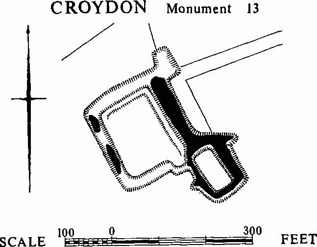
Croydon, Monument 13
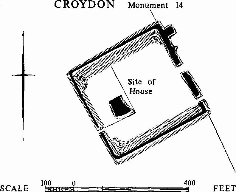
Croydon, Monument 14
b(14) Moated site (Class B; N.G. TL 304514), at Croydon Wilds on boulder clay 264 ft. above O.D., partly overgrown and partly planted with conifers. The moat was probably contemporary with the recently demolished house (Monument (7)), that is to say 17th-century. The enclosed area is 300 ft. square with a wet ditch 30 ft. wide and 3 ft. to 6 ft. deep. Internal banks along the N. and S. sides are 25 ft. wide and 5 ft. high with rounded prospect mounds, 10 ft. to 30 ft. across and 6 ft. high, at the corners. The three entrances by causeways seem to be modern; that near the centre of the E. side, has an early appearance but is not shown on the tithe map of 1839 (T.R.C.). The interior is flat, except for a pond. A disturbed area near the centre of the enclosure marks the house site.
d(15) Deserted mediaeval village (N.G. TL 301487, not on O.S.; Plate 73). The site, 1 m. S.W. of Croydon, is a steep S. scarp of chalk marl with boulder clay at the top and gault clay at the foot; it varies in elevation between 100 ft. and 225 ft. above O.D. and is a good example of a spring-line location: The main earthworks are in pasture, but on the W. a part of the village, probably nearly half its extent of some 33 acres, has been destroyed by ploughing. Quarries have affected their N. end; the largest, with a curving face 200 ft. wide and 25 ft. high, is the most noticeable feature of the hillside. Coprolite digging and military exercises have also caused damage.
The remains are those of the village of Clopton, well documented from 1086 until its enclosure for sheep by John Fisher from c. 1495. In 1356 we learn that manor house and rectory were on opposite sides of the road; the personal name of John atte Dam, occurring in the same year, suggests a mill. The names of several messuages are recorded for 1511. The benefice was united with Croydon in 1561. (W. M. Palmer, 'A History of Clopton, Cambridgeshire', C.A.S. Procs., XXXIII (1933), 3–60, includes a plan of Clapton Dairy Farm, covering the site in 1750; the original is in Downing College.)
Excavations on a small scale in 1960–4, directed by J. Alexander, showed that there was Roman and pagan Anglo-Saxon occupation in the area.
The remains are connected by four roads, (a)–(d). Apart from the two moated sites separately listed, Monuments (16) and (17), the principal sites are of the church (e), and the mill (f). In addition there are fish ponds (g), and a number of house sites (h). (Medieval Archaeology, V (1962), 333–4; VI-VII (1964), 341; D.M.V. Research Group, 12th Report (1964), 13–14.)
(a), the main E. to W. road, still followed by a footpath and formerly the route from Arrington to Tadlow, runs just below the crest of the scarp; it is a lyncheted track 20 ft. wide with a scarp 3 ft. to 4 ft. high to the N. and the steep natural slope on the S. The large quarry, already mentioned, cuts into this track; slight scarps on the N. show that its line has varied slightly. At the W. end it becomes a hollow-way with a platform to the S. 2 ft. high.
(b), a hollow-way, branches from (a) at the N.E. corner of the village remains and sweeps S. in a wide curve; it is 40 ft. to 50 ft. wide, 3 ft. to 4½ ft. deep and 20 ft. to 25 ft. wide across the bottom. As it crosses more level ground the scarps diminish in height and it finally curves S.W. to meet the causeway across the N. side of the moat of Monument (17).
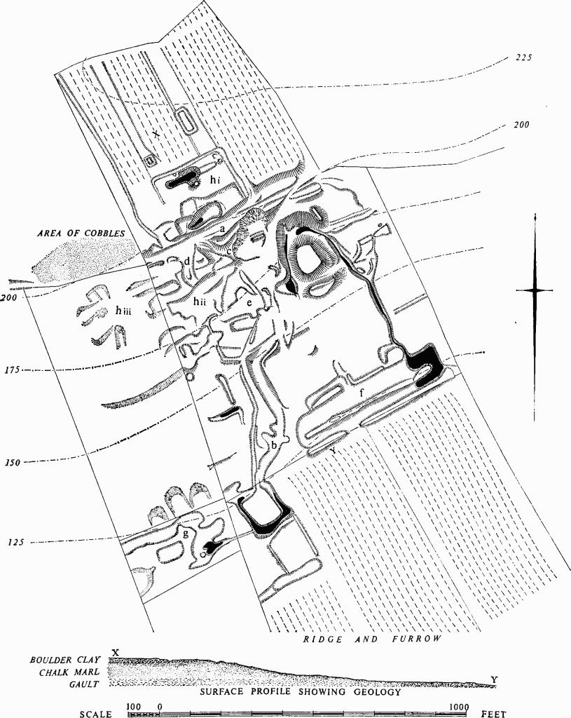
Croydon, Monument 15
Earthworks at the deserted mediaeval village of Clopton
(c), the first of two more irregular and rutted hollow-ways running S.E. from (a) between the quarry and the W. hedge, is 35 ft. wide, 2 ft. to 3 ft. deep and 20 ft. wide across the bottom; after 130 ft. it is blocked by an E. scarp, although it apparently continued to join (b).
(d), to the W. of (c), is 60 ft. wide and 6 ins. to 9 ins. deep at the N. end but gradually narrows to a width of 35 ft. and deepens to 2 ft. After running for 120 ft. it is blocked by a S. scarp belonging to a building platform.
(e), probably the church site, although not that marked on O.S. maps, consists of a platform W. of (b), a rectangular depression to the S. and an enclosing ditch and scarps. Excavation in 1963–4 showed that on the platform, now level within scarps 1 ft. to 2 ft. high, a large E.-W. ditch had been cut into a ground surface with Roman pottery on it, and had in turn been cut by a N.E.-S.W. ditch, both apparently of the Anglo-Saxon period. The depression, orientated E.N.E.-W.S.W., and measuring 80 ft. by 40 ft. with scarps 1½ ft. high on the N. and W., apparently indicates the nave of the church; in 1964 two parallel wall footings, 20 ft. apart and linked by a cross wall, were found at its E. end. The building had had a tiled floor and roof, and glazed windows; it was probably destroyed in the late 17th century. To the S.E. were found four successive layers of mediaeval graves, and there were others on the platform to the N. The scarps and ditch to the S. and W. seem to mark the line of a robbed wall round the churchyard.
(f), probably the mill site, lies in flat ground 350 ft. S.E. of (e), with ridge and furrow running up to it on the S. A sunken and marshy oblong, water-filled at the deeper N.E. end, gave the field in which it is situated its 18th-century name of 'Canal Close'.
The remains, consisting of two parallel depressions 450 ft. long separated by a bank, are best explained in terms of a mill standing on the N.E. end of the bank, the water being held back in the long depressions to the S.W. The N.W. depression is 50 ft. wide and 9 ins. deep at the S.W. end, and 65 ft. wide and 2 ft. deep at the N.E. end. The S.E. depression is 30 ft. wide and gradually deepens from 9 ins. at the S.W. end to 3 ft. at the N.E. end. At the S.W. end these depressions join in a curve, while towards the N.E. end both drop 2 ft. to 3 ft. into the wet portion. The dividing bank is 30 ft. wide and 1 ft. to 3 ft. high. A channel bringing water from the springs to the N. moat enters the N.W. depression near the N.E. end.
(g) fish ponds: slight boggy hollows to the W. of Monument (17) are perhaps to be so interpreted.
(h) house sites, falling into three groups: (i). To the N. of road (a) is a near-rectangular enclosure orientated N.E. and S.W. measuring 230 ft. N.W. by 170 ft. N.E.; it is bounded on three sides by a ditch 12 ft. to 15 ft. wide and 1 ft. deep, with traces of an internal bank. The interior is largely occupied by two quarries and their spoil heaps. To the N. of the S. quarry is a platform 50 ft. square cut back into the hillside. To the W. of the same quarry is a similar platform 35 ft. square and to the E. is a rectangular platform measuring 80 ft. E. to W. by 60 ft., with scarps 2 ft. to 3½ ft. high on the N. and E. A notch in the N. scarp may indicate that two buildings stood here.
(ii). In the angle between the S. side of road (a) and the W. side of hollow-way (b) platforms may indicate house sites. On the W. side of the N. to S. hollow-way (d) is a subrectangular area measuring 70 ft. by 30 ft.; a trench dug here in 1960 produced many cobbles and some 14th-century pottery with a pit 2 ft. deep below. Below these platforms many scarps 3 ft. to 4 ft. high, running N.E. and S.W. along the slope, belong to platforms or terraces cut into one another in no regular pattern, and seem to be the results of successive buildings. Trenches cut across the platform, the N. scarp of which blocks (d), revealed mediaeval pottery overlying Roman pits.
(iii). These platforms continued towards the W. into a field where ploughing has obliterated all but the largest scarps. Slight scoops and scarps, of which the most prominent runs N.E. and S.W. for 280 ft. and is 2 ft. to 4 ft. high, can be distinguished; areas of cobbles and pottery are most noticeable in the N. part of the field. In the field to the N. there are some larger spreads of cobbles and much pottery, including Roman, late Saxon, 13th- and 16th-century sherds.
d(16) Moated site (Class A I (c); N.G. TL 302488) being that of the manor house of Clopton, called Clopton Bury; a child was drowned here in 1348 (W. M. Palmer, op. cit. 55). The roughly circular moat lies on chalk marl at the foot of the steep chalk scarp. It is 70 ft. to 90 ft. in diameter. The ditch on the N. is 100 ft. wide and 5 ft. to 6 ft. below the interior, edged to the N. by a steep curving face 18 ft. to 20 ft. high where springs filling the ditch have caused a recession of the scarp; on the E. and W. the ditch is 40 ft. to 50 ft. wide, 3 ft. to 4 ft. deep to the water level and 15 ft. to 20 ft. across the bottom; on the S. it is dry and nearly straight, 30 ft. to 40 ft. wide and 3 ft. deep with an external bank 50 ft. wide and 3 ft. high at the centre. The springs on the N. and others breaking out in a gully to the N.W. run on either side of the enclosed area, feeding a stream on the E. and a pond, 40 ft. to 50 ft. across, on the S.W. There was a farm here in the 19th century (Downing estate maps 1750, in Downing College; tithe map 1839, T.R.C.; O.S. 6 ins. 1st ed.)
d(17) Moated site (Class A 2 (b); N.G. TL 301485, pond only on O.S.) 230 yds. S.W. of Monument (16) on gault clay. The earthworks of the deserted village lie to the N. The only dating evidence is a sherd, possibly 11th-century, found in the outer edge of the E. ditch of the moat. A roughly rectangular enclosure measuring 85 ft. N. by 105 ft. E. by 80 ft. S. by 97 ft. W. is surrounded by a wet ditch 25 ft. to 40 ft. wide (widest on the S.), 2 ft. to 3 ft. deep and 15 ft. to 20 ft. wide at water level. On the S. is a slight external bank 20 ft. wide and 6 ins. to 9 ins. high. A causeway 10 ft. wide crosses the N. ditch near the centre but is 6 ins. below the level interior and does not appear to be original, though lying at the end of the hollow-way through the village (Monument (15) (b)) which connects the two moats. Attached to the S. side is a roughly rectangular enclosure measuring 110 ft. N. by 135 ft. E. by 98 ft. S. by 108 ft. W. Its E. and W. sides are formed by banks 12 ft. to 20 ft. wide and 6 ins. to 1 ft. high, best preserved on the E.; the S. side is a pond, now dry, 3 ft. to 4 ft. deep.
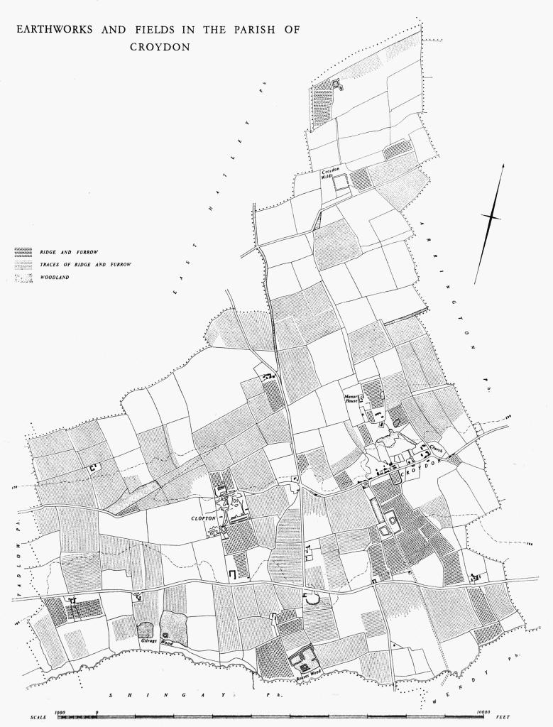
Earthworks and Fields in the Parish of Croydon
d(18) Pillow mounds, two (N.G. TL 30044891 and 30074894, not on O.S.), in pasture on level ground above the chalk scarp 220 ft. above O.D. and immediately N. of the deserted mediaeval village of Clopton (Monument (15)). Both mounds are orientated N.N.W. and S.S.E. and are rectangular with flat tops; each lies in a strip, left unploughed, between blocks of ridge and furrow.
The W. mound is 20 ft. long, 8 ft. wide and 1 ft. high and is surrounded by a ditch 15 ft. wide and 9 ins. to 1 ft. deep. The E. mound is 65 ft. long, 18 ft. wide and 2 ft. high within a ditch 15 ft. wide and 9 ins. to I ft. deep; a slight depression crossing it in the centre is presumably due to a cutting made in 1933; no finds were made (W. M. Palmer, op. cit. 60).
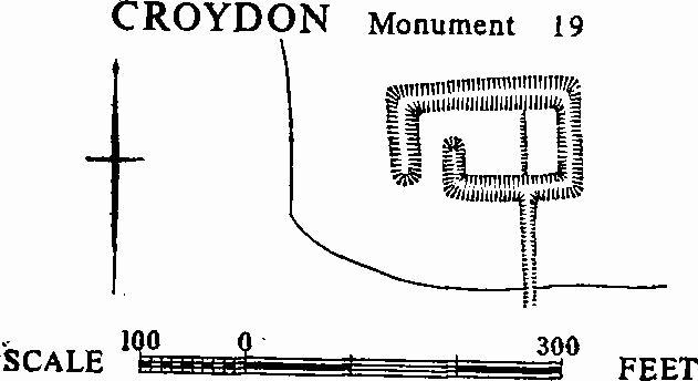
Croydon, Monument 19
c(19) Moated site (Class A 1 (a); N.G. TL 299476, not on O.S.), near the S.W. corner of Gilrags Wood and overgrown with trees. The moat, 132 ft. E. to W. by 65 ft., is rectangular with a ditch 20 ft. to 30 ft. wide and 3 ft. to 5 ft. deep which has been partly filled for 55 ft. of the S. side. The entrance at the S.W. angle is by means of a causeway 20 ft. wide flanked on the E. by an arm of the ditch at right angles to the S. side projecting 33 ft. to the N. (for a similar entrance see Boxworth (15)).
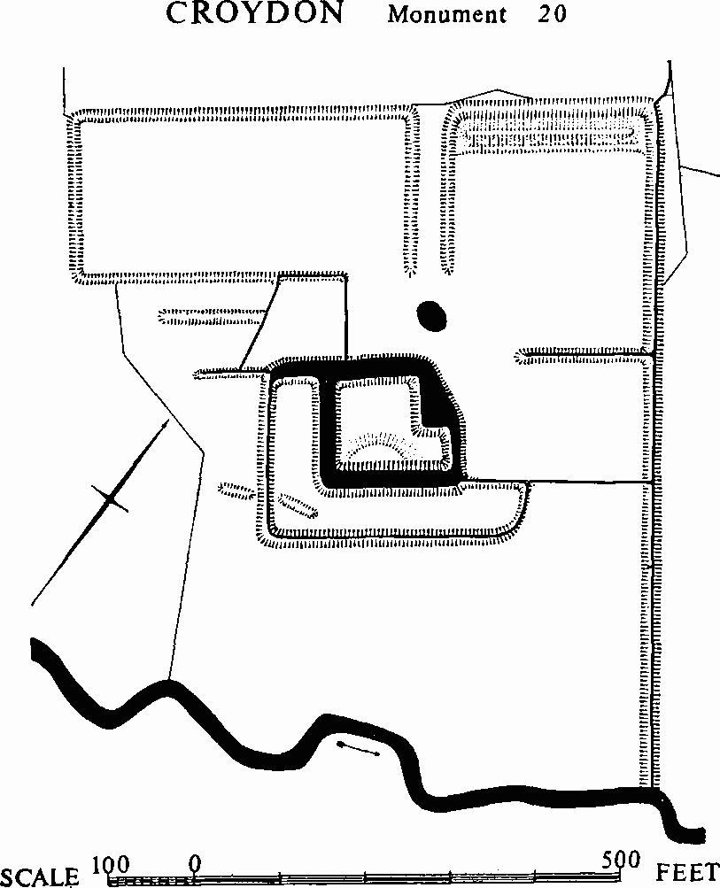
Croydon, Monument 20
d(20) Moated site (Class A 2 (c); N.G. TL 310477, not on O.S.), in Rouses Wood, on gault clay with the River Rhee immediately to the S. Later drainage channels and thick under-growth make the lay-out difficult to follow, but the defensive moat which forms the nucleus is with little doubt that of the manor house of Rouses named after the le Rous family which is mentioned in documents from 1198 onwards (W. M. Palmer, op. cit. 9–10; Reaney, 'Place-names of Cambs.' 54; 13th- and 14th-century sherds have been found within the moat. The remains consist of this moat together with an L-shaped annexe along its S.W. and S.E. sides, and two outer enclosures to the W. and N. respectively; these last, separated by a narrow causeway from the N.W., are both rectangular, but with gaps at the corners nearest the moat.
The moat encloses an island 82 ft. N.W. by 92 ft. N.E. by 90 ft. S.E. by 85 ft. S.W., but with a projection 30 ft. long and 28 ft. wide at the S.E. end of the N.E. side; the ditch is 30 ft. to 60 ft. wide, 3 ft. to 4 ft. deep with 1 ft. to 2 ft. of water. The entrance was probably at the projecting S.E. corner; near it, inside the moat, is a mound 30 ft. across and 1½ ft. high. The L-shaped annexe 35 ft. wide, a wet ditch 19 ft. to 30 ft. wide and 2 ft. to 3 ft. deep.
The W. enclosure lies 100 ft. to the N.W. of the moat and measures 384 ft. N.E. to S.W. by 180 ft. with a ditch 20 ft. wide and 9 ins. deep; the N.W., S.W. and part of the S.E. sides are the boundaries of the wood. The N. enclosure measures 220 ft. N.E. to S.W. by 260 ft.; its ditch is 15 ft. to 20 ft. wide and 6 ins. deep, and there is an internal bank on the N.W., 27 ft. wide and 9 ins. high with a ditch 15 ft. wide and 6 ins. deep within it; the N.W. and N.E. sides are on the boundaries of the wood. The causeway between the two enclosures is slightly raised and rounded and is 30 ft. wide.
(21) Cultivation remains (not on O.S.). Ridge and furrow 70 yds. to 360 yds. long, 6 yds. to 9 yds. wide and 6 ins. to 1 ft. high with headlands of 5 yds. to 11 yds. is preserved around the deserted village of Clopton, N. and W. of Rouses wood, S. of Croydon village, and at a few other places in the parish.
Traces of similar ridge and furrow, usually straight and fitting the existing field boundaries, appear on air photographs in nearly every field. The ridges vary, from field to field, between 100 yds. and 360 yds. in length and between 5 yds. and 11 yds. in width. The present pattern is different from the usual open-field arrangement. It seems likely that after enclosure the land was used for pasture; and subsequently for arable, leaving the generally new pattern of ridge and furrow now visible.
A terrier of 1546 gives the names 'West', 'North' and 'Middle' Fields for Croydon, also many names of access ways and furlongs. None corresponds with those recorded in 1750 when estate plans were made for Sir Jacob Downing and Thomas Gape; by that time most of the present field divisions already existed.
Clopton seems to have had two fields in the 13th century and was enclosed c. 1495 by John Fisher.
(Ref: terrier of strips 1546; plans of Gape estates 1747 (C.R.O.); plans of Downing estates 1750 (Downing College); tithe map 1839 (T.R.C.); W. M. Palmer, C.A.S. Procs., XXXIII (1933), 3–60; W. E. Tate, C.A.S. Procs., XL (1944), 58; air photographs: 106G/UK/1635/3490–3; CPE/UK/1993/ 4115–9; CPE/UK/2024/3018; 3057–61; 3083–5; 4102–4.)