An Inventory of the Historical Monuments in the County of Cambridgeshire, Volume 1, West Cambridgshire. Originally published by Her Majesty's Stationery Office, London, 1968.
This free content was digitised by double rekeying. All rights reserved.
'Dry Drayton', in An Inventory of the Historical Monuments in the County of Cambridgeshire, Volume 1, West Cambridgshire(London, 1968), British History Online https://www.british-history.ac.uk/rchme/cambs/vol1/pp80-82 [accessed 30 April 2025].
'Dry Drayton', in An Inventory of the Historical Monuments in the County of Cambridgeshire, Volume 1, West Cambridgshire(London, 1968), British History Online, accessed April 30, 2025, https://www.british-history.ac.uk/rchme/cambs/vol1/pp80-82.
"Dry Drayton". An Inventory of the Historical Monuments in the County of Cambridgeshire, Volume 1, West Cambridgshire. (London, 1968), British History Online. Web. 30 April 2025. https://www.british-history.ac.uk/rchme/cambs/vol1/pp80-82.
In this section
14 DRY DRAYTON
(O.S. 6 ins. aTL 36 S.E., bTL 46 S.W., cTL 35 N.E.)
The parish of Dry Drayton, 2421 acres in extent, is four-sided; the land at its lowest is c. 60 ft. above O.D., at the N.E. end, where the Cambridge to Huntingdon road is the boundary, and highest, about 230 ft., at the S. end which stops against the Cambridge to St. Neots road.
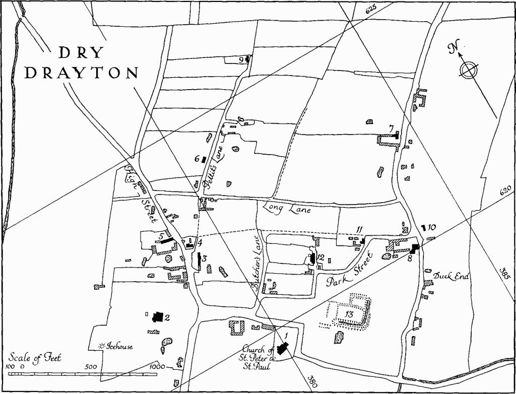
Dry Drayton
The soil is boulder clay on the higher ground and gault on the lower ground; the village lies at the junction of the two. In the middle ages Dry Drayton was sometimes known as Wood Drayton (Reaney, 'Place-names of Cambs.', 152). Cole (B.M. Add. MS. 5849, 156) is no doubt correct in saying that the epithet 'Dry' has no positive significance; the place is merely so called 'for that it standeth in the Upland and Champion countrie, thereby to distinguish it from the other Drayton, which taketh appellation from the Fenne'. F. A. Walker (History of Dry Drayton (1876), 1, 74) mentions 'a well of water of ancient date' in Drayton Park (Monument (13)). 'Lord's Spring', some 300 yds. S.W. of the church, presumably indicates an additional source.
Drayton Park was the site until 1817 of the Duke of Bedford's mansion, sketched by Relhan in 1809, and anciently, in all probability, of the manor held by the Abbots of Crowland from 1066 (V.C.H., Cambs. 1, 371), until the Dissolution.
The village appears to have been laid out at an unknown date in the form of a lozenge. Old closes are divided by a number of intersecting parallel lanes save in the S. corner which is occupied by the church and the site of the mansion. 'High Street', formerly the Long Stanton road which is now disused, ignores this pattern and has presumably been superimposed on it. The lay-out was more complete when the survey map of 1802 (C.R.O.) was made for the enclosure, which probably resulted in the suppression of some of the lanes; it has since been further effaced by the enlargement of the rectory garden and by modern realignments of the road to the N.E. as well as by gradual decay.
Ecclesiastical
a(1) Parish Church of St. Peter and St. Paul, consisting of rebuilt chancel, Nave with Aisles, and West Tower, is on the S. side of the village, towards the S.W. end of its rectangular churchyard. It has been continuously affected by subsidence and has been much restored as a result. The original walling, where it survives, is of field stones, in some places banded with clunch, with freestone and clunch dressings; modern work, some at least in brick, is faced up with reused broken ashlar and dressings. The roofs are covered with slates. The nave, both aisles, and the tower seem to originate in a comprehensive rebuilding of the late 13th century. In the 14th century the N. arcade was rebuilt and the aisles widened. The chancel, having been shortened c. 1768, is stated by C. H. Evelyn-White (Churches of Cambs., 60) to have been 'extended to its original dimensions' in 1851; it retains no old work. The tower was restored in 1874.
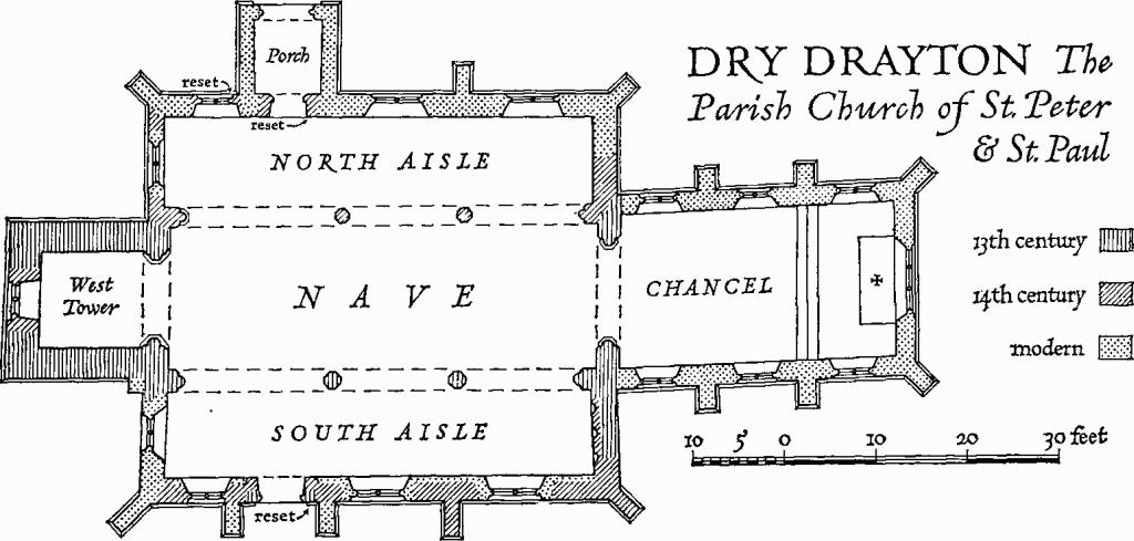
Dry Drayton, the Parish Church of St. Peter & St. Paul
Architectural Description—The late 13th-century chancel arch is of two chamfered orders, the outer continuous, the inner rising off part-octagonal responds with moulded caps (possibly re-worked) and worn bases; on the W. face is a hood mould with head stops.
The Nave (46½ ft. by 15¾ ft.) has three arches on either side, the last being wider in each case than the others; all are of two chamfered orders rising off octagonal piers with responds having the outer order carried down from the arch, and partoctagonal attached shafts. The piers and responds have moulded caps of varying section, but no bases are visible. The 14th-century N. arcade has moulded labels on both sides with stops carved as heads or half-figures; the late 13th-century S. arcade has a label towards the nave only, with head stops. The clearstorey is modern.
The North Aisle (9¾ ft. wide) has been largely rebuilt although parts of the E. and W. walls are 14th-century. The reset 14th-century N. doorway has shafted jambs partly continuous with the moulded head. The W. window in the N. wall has two lights with a quatrefoil in a two-centred head with an external label terminating with head stops; the transom and cusping to the lower lights is modern and the window, although taller than that shown by Cole (B.M. Add. MS. 5810, 86) and much restored, retains some 14th-century work. The W. window incorporates a few old jamb stones. The South Aisle (9½ ft. wide) has a blind E. wall, the N. part of which reflects the former narrow 13th-century aisle. The S.E. angle buttress and the first buttress, both of three stages, are coeval with the 14th-century S. wall. The restored and reset late 13th-century S. doorway has continuously moulded jambs and head with a moulded label. The W. window in the S. wall is uniform with that in the N. aisle but less restored. Internally, part of the splays and springing of wall arcading, described by J. H. Parker (Ecc. Top. Cambs. § 77), and now blocked flush, is visible. The N. Porch has been rebuilt and a S. porch removed.
The West Tower (11 ft. by 10½ ft.), of three stages, is of 13th-century origin. The arch is original and is of three orders, of which the innermost is carried on part-octagonal responds, with moulded, possibly re-worked, caps and moulded bases; a moulded label on the E. face has head stops. The 14th-century window, of two cinque-foiled lights, with casement-moulded jambs, has a quatrefoil in the head between two vertical bars and an external label with head stops. The remaining windows are modern.
Fittings— Bells: five, by Joseph Eayre of St. Neots, 1746. Bell frame: old, perhaps reconstructed in 1746. Brass: immediately W. of chancel arch, of male and female figures with shield of arms above them and indents below for inscription panel and two groups of children; the man, who is in armour of mixed plate and mail, has his head resting on a tilting helm; the arms are of Hutton, but with a border engrailed; c. 1540 (Plate 112). Brass indent: In chancel, of a male figure with inscription plate and two shields, mediaeval Font: octagonal limestone bowl with chamfered upper and lower edges, on a restored base consisting of a rectangular block with a semi-octagonal half shaft on each face; 13th-century. Glass: In E. window, memorial (Plate 24) to Rev. Samuel Smith, D.D., sometime Dean of Christ Church, Oxford, rector, 1841; Anne, his wife, 1826; and Rev. Samuel Smith, their son, rector, 1831. God the Father is depicted with St. Peter to his right and St. Paul to his left; below are shields of arms and the kneeling figure of a cleric; a miniature shield bears the monogram, TW (for Thomas Willement) and date 1853. Monuments and Floor slabs. Monuments: In chancel (1) of Rev. Samuel Smith, 1841 (see under Glass); in churchyard, by N.W. angle of N. aisle; (2) of Michael Gifford, 1711, headstone; there are a number of later 18th-century headstones Floor slab: in chancel, of Rev. Richard Bullock, rector 1757– 178(?); his wife, Ann, 1765; their children Ann, 1757; Edward, 1765; Patty, 1770; and Ann, 1770; his wife Lucy, 1784; and their children, Charles, 1775; Marianne, 1775; and Frances, 178(?). Niches: In E. wall of S. aisle, three, with decorative vaulting in the heads, mutilated, 14th-century. Plate: includes cup and cover paten (Plate 23), London, 1588, both inscribed with initials 'RG'; stand paten, London 1685; and cup and paten, probably Paris, late 17th-century.
Secular
a(2) Rectory, three-storeyed, of white brick with hipped slate roofs, in a conservative Georgian idiom, was built in 1830–1 and subsequently extended. The garden elevation to the S.E. is in four bays two of which project slightly to form a pedimented centrepiece. The house is entered from the N.E. side. The plan allows for two ample ground-floor rooms. The icehouse, 160 yds. to the W., is contemporary.
a(3) Cotton's Farm, framed and plastered, with tiled roofs, now three dwellings, appears to have originated as a twostorey Class-J house of the late 17th century, to the S. end of which a Class-I structure was added in the 18th century. The earlier building has been partially rebuilt in brick.
a(4) Houses, a pair, with shared central chimney, of one storey and attic; framed, plastered and thatched; 18th-century; a moulded ceiling beam in the E. house, with carved stop at one end, is reused.
a(5) Farm building, with pigeon loft, of red brick, attached to the W. end of a range of sheds and sharing its thatched roof; nesting boxes in the W. gable; 18th-century.
a(6) House (Class J), of one storey and attic, framed and plastered, with thatched roof, is late 17th- or early 18th-century. A rent slip of 1757 discovered under the floor was for 17s. 6d. a half year.
a(7) Craft's Farm, framed and plastered, with tiled roofs; partly of one, partly of two, storeys with attics; originated in the 17th century as a Class-I house with a continuous jetty on the N. side. In the 18th century the original central chimney was removed and a wing added at the E. end of the N. side to make an L-shaped plan, with chimneys at the ends and at the junction of the two ranges. There are some replacements in brick and a modern extension of the original house to the E.
a(8) View Farm (Class L), of two storeys, is in red brick, some of which has been renewed, with gabled and hipped tiled roofs; inside are some chamfered ceiling beams with jewelled stops and doors of two fielded panels; 18th-century.
a(9–12) Houses (Class J), one storey and attics, framed and plastered, with thatched or tiled roofs; 17th- and 18th-century, with alterations.
Earthworks
a(13) Moated site (Class B; N.G. TL 382619, not on O.S.), in a flat grass field known as 'The Park', on gault clay, 500 ft. E. of the church. It is that of the manor house, demolished in 1817, which had belonged to the Dukes of Bedford. The remains consist of a garden moat and adjacent platform.
The L-shaped ditch is 40 ft. to 50 ft. wide and 1½ ft. deep; an outer bank is about 1½ ft. high. The ditch N.E. of the moat is V-shaped about 2 ft. deep with an internal bank 1½ ft. high. N.W. of the moat is a rectangular platform, apparently for a house, 125 ft. by 60 ft. A pond lying further S. is probably modern.
(14) Cultivation remains (not on O.S.). Much ridge and furrow is preserved in the small closes around the village, scheduled as old enclosures in 1811. The remains have straight ridges 100 yds. to 300 yds. long, 7 yds. to 9 yds. wide and 9 ins. to 1 ft. high with headlands 5 yds. to 8 yds. wide; nearly all run N.W. and S.E.
Traces of curving furlongs can be seen on air photographs mainly in the S. of the parish, most clearly in the S.W. around N.G. TL 368609; these lay in the open fields, called 'Callow', 'Long' and 'Stone' Fields, enclosed in 1811.
(Ref: enclosure maps 1802 (C.R.O.); air photographs 106G/UK/1490, 3242–6, 3340–4, 4383–5.)