An Inventory of the Historical Monuments in Dorset, Volume 3, Central. Originally published by Her Majesty's Stationery Office, London, 1970.
This free content was digitised by double rekeying. All rights reserved.
'Winterborne Kingston', in An Inventory of the Historical Monuments in Dorset, Volume 3, Central(London, 1970), British History Online https://www.british-history.ac.uk/rchme/dorset/vol3/pp300-305 [accessed 30 April 2025].
'Winterborne Kingston', in An Inventory of the Historical Monuments in Dorset, Volume 3, Central(London, 1970), British History Online, accessed April 30, 2025, https://www.british-history.ac.uk/rchme/dorset/vol3/pp300-305.
"Winterborne Kingston". An Inventory of the Historical Monuments in Dorset, Volume 3, Central. (London, 1970), British History Online. Web. 30 April 2025. https://www.british-history.ac.uk/rchme/dorset/vol3/pp300-305.
In this section
54 WINTERBORNE KINGSTON (8697)
(O.S. 6 ins. SY 89 NE, SY 89 NW, ST 80 SE)
This parish has an area of 2,559 acres and lies on both sides of the Winterborne stream, at altitudes between 160 ft. and 400 ft. above sea-level; the land is mainly Chalk. Until 1650 Kingston was combined with the adjacent parish of Bere Regis (Dorset II, 11–22); since then the civil parish has been independent, but the church remains a chapel-of-ease to Bere. The civil parish includes three original settlements: Kingston, Turberville and Muston. Kingston and Muston may well be represented among the numerous Domesday entries for the eastern group of Dorset Winterbornes. Kingston and its open fields occupied the western two-thirds of the area; Turberville, to the E., is now called Abbot's Court; Muston lies still further E. and the common identification of Muston with Turberville is an error. The church is the most notable monument.
Ecclesiastical
(1) The Church of St. Nicholas stands in the S.E. part of the village. The walls are of flint and Heathstone rubble with ashlar dressings; the roofs are tiled. The Chancel, Nave, West Tower and South Porch are of 14th-century origin but were extensively restored in 1871, under G. E. Street, when the North Aisle and the North Vestry were added.
Architectural Description—In the Chancel (22 ft. by 14 ft.), the E. window and the archway in the N. wall are of 1871. In the S. wall is a partly restored 14th-century doorway with chamfered jambs and a segmental-pointed head; further W. is a 14th-century window of two trefoil ogee-headed lights with a quatrefoil in a two-centred head. The chancel arch is of 1871.
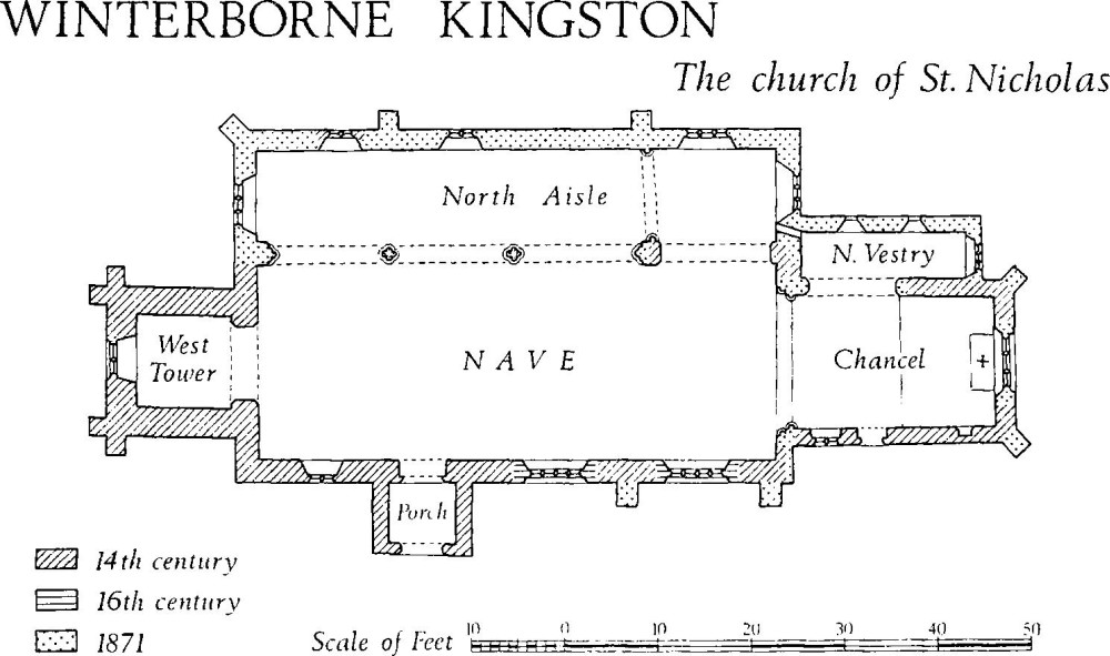
Winterborne Kingston, the Church of St. Nicholas
In the Nave (56 ft. by 21 ft.), the N. arcade is of 1871 but the easternmost arch, with chamfered responds, differs from those to the W. and probably represents an earlier opening; this presumably led to the 'Muston Aisle' (Hutchins I, 146), now wholly rebuilt. In the S. wall are three windows; the two to the E. are of the 16th century and square-headed, each with four four-centred lights in casement-moulded surrounds. The S. doorway is of the 14th century and has a moulded and chamfered two-centred head with continuous jambs, and a chamfered reararch with cinquefoil cusping. The western window of the S. wall is of the 14th century and has two two-centred trefoil-headed lights; a similar window is reset in the N. wall of the 19th-century N. aisle.
The West Tower (10 ft. square) is of the 14th century. Externally it is not divided into stages but it has ashlar angle buttresses of two weathered stages at the N.W. and S.W. corners; at the top is an embattled parapet with a weathered and hollow-chamfered string-course and a moulded coping. Internally there are three storeys. The tower arch is two-centred and of three chamfered orders dying into the responds. The partly restored W. window is of two trefoil-headed lights with a quatrefoil in a two-centred head; to the N. of the W. window, on the outside face of the tower, are two reset pieces of Ham Hill stone, curved in outline and perhaps parts of a former window. The second storey has a small square-headed loop in the N. wall. The belfry has, in each wall, a two-centred window of two trefoil-headed lights with a quatrefoil above; reset over each window and at each corner of the tower is a mediaeval head-corbel. The South Porch has a 14th-century two-centred archway with ovolo and hollow-chamfered mouldings, continuous jambs, and chamfered stops.
Fittings—Bells: four; 1st, 2nd and 3rd by John Wallis, 1600, inscribed respectively 'Feare God', 'Prayse God' and 'Love God', 4th by William Elery, 1749. Brackets: In nave, on E. splay of middle S. window, octagonal tapering bracket; beside pulpit, stone corbel with chamfered edges. Candelabra: In chancel, scrolled brass wall-brackets, late 17th or early 18th century. Chest: In N. aisle, of hutch-type with old lock, late 17th century. Coffin-lids: In tower, two tapering Purbeck marble slabs with double hollow-chamfered edges and raised crosses, 13th century. Coffin-stools: pair, with turned legs, late 18th century. Communion Table: In N. aisle, of oak, with turned legs and fluted top rails, late 17th century. Font: of baluster form with ogee-moulded bowl, dated 1736 on pedestal; font cover, of oak, dome-shaped, with pineapple finial, 18th century. Glass: see below, (3) North Farm. Monuments: In tower, on N. wall, (1) of Eliza Hussey, 1821, marble tablet. In churchyard, 20 paces S. of tower, (2) of Jenny Read, 1795, and others of same family, headstone with shaped top. Piscina: In chancel, recess with trefoil ogee head and round bowl with outlet, 14th century. Plate: includes silver-gilt cup of Elizabethan form, without date marks, probably late 16th or early 17th century; also silver-gilt paten without marks, perhaps 17th century; also silver flagon and paten of 1811 with donor's inscriptions. Pulpit: of oak, octagonal, with two heights of moulded panels and frieze of carved panels, early 17th century. Miscellanea: In vestry, reset in S. wall, fragment of a cresset-stone with two holes, probably mediaeval.
Secular
(2) Plumley Farm (86039765), house, stands 200 yds. W. of the church. The W. part of the house is of 17th-century origin and has walls partly of cob, partly brick-faced and partly rendered; it is single-storied with a dormer-windowed attic. The E. part is of the late 18th century and two-storied; it has a four-bay S. front of Flemish-bonded brickwork, patterned with blue headers and with a plat-band at first-floor level. Both parts of the house have modern tiled roofs.
Inside, the ground-floor rooms are spanned by chamfered beams. The attic chamber of the W. part has a fireplace with a cambered and chamfered timber bressummer. Over this is some 17th-century moulded plaster wall enrichment in which two sprays of acorns and oak leaves flank a central arabesque with tendrils, leaves and seed-pods; above is a fragment of another spray.
(3) North Farm (86179786), about 270 yds. N. of the church, is the house described by Hutchins (I, 145) as William Little's farm. It is of two storeys, with walls of brick, flint and cob, and with tiled roofs; it appears to be of mid 18th-century origin but it was extensively altered and enlarged in the 19th century and again more recently. The gabled E. wall of the 18th-century range is surmounted by two diagonal brick chimneystacks. Towards the E. end of the upper storey the N. wall has a timber window of four chamfered square-headed lights under a coved lintel; this is said to be the window in which the heraldic glass of the Daccomb family, described by Hutchins, was formerly set; the glass has now been removed (see below).
Inside, some rooms have exposed lightly chamfered beams. The stairs are probably of the late 18th century, with open strings, three turned balusters to each tread and a moulded handrail ending at the bottom in a horizontal volute.
The heraldic glass noted by Hutchins is now preserved at 'The Pines', Salisbury Road, Ringwood, Hampshire. There are four shields with strapwork surrounds. One shield has the arms of Twynihoe impaling Daccomb, the latter reversed; the second has Daccomb impaling two coats per fess (unidentified 17, 18); the third has quarterly Touchet, Willoughby?, Filiol or Parentyn and Martin, impaling Daccomb; the fourth has Daccomb paly with a blank coat. A lozenge-shaped quarry has the Daccomb griffin; another quarry is inscribed 1601. The impalements appear to record alliances of the Daccomb family in the late 16th or early 17th centuries; a Twynihoe-Daccomb marriage took place in 1631.
(4) Muston Farm (87149866), house, some 920 yds. E. of the church, is of two stories and has walls partly of coursed rubble and partly of banded brick and flint, and slated roofs. It is probably of 17th-century origin but it was extensively rebuilt late in the 18th or early in the 19th century.
The E. front is of four bays and is principally of banded flint and brickwork, representing the later rebuilding, but a slightly projecting wall of coursed rubble at each end of the elevation appears to survive from the earlier period. In height these walls rise only to the level of the first-floor window-sills, indicating that the house was formerly single-storied. The W. front is of mixed rubble and brickwork with an ashlar quoin at the N.W. corner. The gabled N. and S. end walls and the southern part of the W. wall are masked by additions that are probably of the late 18th century. Inside, the plan of the original range comprises a through-passage with one room to the N. and two rooms to the S.; the two southern rooms are separated from the W. wall by a passage which ends, to the S., at a doorway with a head with a raised centre.
(5) House (87359708), about 200 yds. E. of the foregoing, is of one storey with an attic and has brick walls and a thatched roof. The central part of the range appears to be of the late 17th century; the additions to E. and W. are probably of the 18th century.
The S. front (Plate 58) is symmetrical and of five bays; the middle bay, containing the doorway, has a projecting two-storied five-sided porch, probably of the 18th century and perhaps inspired by that of Anderson (2) which stands only 1 m. to the E.; it has a round-headed archway with a projecting keystone and impost blocks, and in the upper storey it has a small stone window of one elliptical-headed light with recessed spandrels and a weathered, hollow-chamfered hood-mould. The windows of the adjacent bays have plain wooden casements with shallow segmental brick heads; the additional bays to E. and W. are set a few inches back from the original façade and have similar but slightly larger windows.
Inside, the ground plan of the original range comprised only two rooms; one has a large open fireplace, the other had a smaller fireplace, now blocked up. The E. and W. additions are each of one room. Throughout the house the rooms are decorated with a richness that is exceptional for a rural dwelling. On the ground floor, the room to the W. of the entrance is lined from floor to ceiling with fielded panelling in two heights, with a moulded cornice and a moulded dado rail. The room in the W. extension has a panelled dado with a moulded rail, and a ceiling cornice enriched with acanthus ornament, egg-and-dart mouldings and a hollow-chamfer; the added room at the E. end on the ground-floor has a panelled dado. In the attic storey the E. bedroom is lined from floor to ceiling with two heights of fielded panelling. The two bedrooms of the original range have similar panelling, with moulded cornices; the ceilings are coved and segmental in cross-section. In the W. attic the floor-level is higher than elsewhere.
(6) Cottage (87169751), 130 yds. S. of the foregoing, is single-storied with attics and has walls of cob and brick, and a thatched roof. It was built at two periods, the E. part of the range being of the late 17th century while the W. part is of the late 18th century; the two parts were formerly separate tenements although now combined as a single dwelling. The 17th-century range has cob walls and the 18th-century walls are of brick.
Inside, the original range has two ground-floor rooms divided by a plank-and-muntin partition; the W. room is the larger of the two and has an open fireplace with a bread oven to the N.; the other room is unheated. The ceiling of the W. room rests on two chamfered beams and chamfered wall-plates; the fireplace is spanned by a stop-chamfered bressummer and above it the two ceiling beams are shouldered; to the E., where the beams rest on the plain head of the plank-and-muntin partition, the chamfers are stopped. The attic is divided into three small rooms by plank-and-muntin partitions, and one room is spanned by a chamfered beam with shaped stops. The ground-floor room of the 18th-century extension has two stop-chamfered beams, and a fireplace set back to back with the original chimney-breast.
(7) Cottage (86249756), 50 yds. S. of the church, is single-storied with an attic and has cob walls and a thatched roof; it was probably built early in the 17th century. Inside, a chamfered beam is exposed and the attic contains a chamfered doorway with a four-centred head. (Demolished.)
(8) Cottage (86249768), 100 yds. N. of the church, is two-storied with walls of stone and cob, and a thatched roof. The nucleus is of the early 17th century. Chamfered beams are exposed inside and one first-floor window retains an original chamfered timber surround.
(9) Cottage (86109768), 130 yds. N.W. of the church, is two-storied and has rendered walls, probably of cob, and a thatched roof; it is of the late 17th or early 18th century. The E. front is symmetrical and of five bays, with a central doorway and two casement windows on either side; on the first floor are four two-light casement windows, one of them original and with a moulded timber surround. The fireplaces and chimney-stack are at the centre of the range.
Monuments (10–18)
Unless described otherwise, the following monuments are single-storied with attics and have cob walls and thatched roofs. They are of the 18th century.
(10) Cottage (86449765), originally a pair but now united to make one dwelling, stands 230 yds. E. of (1). The E. front, of four bays, was rebuilt in banded brick and flint in the 19th century but the other walls are original and of cob. The ground plan of each original tenement consisted of two rooms, one with a fireplace and one unheated. The fireplaces are set back-to-back and have a common chimney-stack on the party-wall; they have stop-chamfered bressummers and formerly had ovens beside them, but only one of these survives. Each heated room is spanned by a chamfered beam.
(11) Cottage (86299774), 170 yds. N.E. of (1), is two-storied and has recently been re-roofed with tiles and divided into two tenements. The W. part of the range has an original winding staircase and an open fireplace, now blocked. The ceiling beams are unwrought.
(12) Cottage (86209764), 60 yds. N.W. of (1), is two-storied. The W. front is approximately symmetrical and of five bays with a central doorway; the chimneystacks are on the gabled N. and S. walls. Inside, at the S. end of the range is an open fireplace with a stop-chamfered bressummer. The ceiling beams are unwrought.
(13) Cottage (86269750), 120 yds. S.E. of (1), was partly rebuilt in the 19th century. The ground plan is of three bays with the chimney-stack between the central bay and that to the W. Each bay is spanned by a roughly chamfered longitudinal beam. A partition has been removed and the central bay and that to the E. have now been made into one room, a post being inserted to support the beams.
(14) Cottage (86239751), 120 yds. S. of (1), has a S. front of three bays; the entrance was originally in the middle bay but it has now been transferred to a modern W. extension. Inside, the ground floor contains two original rooms; that to the W. has a fireplace and is spanned by a longitudinal chamfered beam. The E. room is unheated.
(15) The Old Parsonage (86439762), 200 yds. E. of (1), is two-storied and has rendered brick walls. The N. front is approximately symmetrical and of four bays, with a central doorway in a gabled single-storied porch. The first floor is marked by a plat-band. The ground-floor windows have segmental heads and those of the first floor are square-headed; the window sashes appear to be of the 19th century. One of the first-floor openings has been blocked. A chimney-stack occurs on each gabled end wall and a third stack occurs near the middle of the range. Internally the house appears to have been extensively remodelled about the middle of the 19th century.
(16) Cottage (87179746), 950 yds. E. of (1), is probably of the late 18th century but it has been much altered. The E. and W. fronts are now of four bays and the original fenestration has been lost. The fireplaces and chimneystacks are on the gabled N. and S. end walls. Inside, the plan has been modified but it probably consisted originally of a through-passage with two rooms to the N. and one room to the S. The kitchen, at the N. end, has three chamfered beams; other beams occur at the heads of the throughpassage partitions and a chamfered beam occurs in the S. room.
(17) Cottages (85689779), originally a range of four tenements but now converted to make two, stand about 600 yds. W. of (1). The range is two-storied and of four bays; each original dwelling had one room on each floor. On the ground floor the fireplaces are set back-to-back, with two chimneystacks symmetrically disposed in the range.
(18) Malthouse (8569765), 150 yds. S. of the foregoing, is probably of the 18th century; it is now used as a barn and has been much altered. The plan comprises a long E.-W. range, with a malting kiln to the N., at the W. end. Inside, traces can be seen of two upper floors, now removed; the first floor was only 5 ft. above the ground floor. The floor of the kiln is of perforated bricks supported on iron beams.
The following monuments are probably of the first half of the 19th century—Abbot's Court Dairy (86689795), a brick-built house and barn, stands on the site of the former Abbot's Court (Hutchins I, 148). The Greyhound Inn (86199782), 240 yds. N. of (1), has cob walls and tiled roofs. A House (86329761), 80 yds. E. of (1), with walls of banded brick and flint, was formerly the Bush Inn. North West Farm (85949764), house, 300 yds. W. of (1), has walls of brick and of banded brick and flint. A House and Shop (86199751), with cob walls and slated roofs, was a range of three tenements until c. 1900. Cottages, two adjoining (86299764), with walls of brick and cob, and slated roofs, are said to have originated as one house, perhaps in the 18th century. Hill Barn (86789895), 1,600 yds. N.W. of (1), is partly of banded brick and flint and partly of cob; the roofs are slated.
Mediaeval and Later Earthworks
(19) Settlement Remains (871976) of the former hamlet of Winterborne Muston are found near Muston Farm; they consist of about 3 acres of very disturbed scarps and banks, and form no coherent pattern except for a small enclosure immediately E. of the farm. The enclosure is a rough rectangle, 40 yds. by 25 yds. and is bounded by low banks.
(20) Cultivation Remains. The three-field system at Winterborne Kingston remained largely unenclosed until 1848 (Map and Award, D.C.R.O.; also Tithe Map 1842). The fields can now be seen only as traces of ridge-and-furrow on air photographs (R.A.F. CPE/UK 1934: 2122–3); they occur S. of West Down Barn (847976), in the former 'Little Field', and N. of West Down Barn (847985), in the former 'North Field'. Projecting S.W. from the boundary of 'Little Field' (847975) are the stubs of some strip fields that probably belong to an earlier system; they lie at right-angles to the fields that were enclosed in 1848 and perhaps indicate that the open fields were laid out anew at some period.
Little is known about the open fields of Winterborne Muston, but they certainly existed; the final exchange of intermingled lands was effected in 1774 (Map of Intermixed Lands at Muston, copy in D.C.R.O.). Slight remains of seven flat strips, 20 yds. to 25 yds. wide and at least 200 yds. long, bounded by low banks, exist N. of Muston Farm (873987).
Roman and Prehistoric
(21) Romano-British Well on Kingston Down, excavated by J. C. Mansel-Pleydell in 1890, is not precisely located. The finds are in D.C.M. The well lay at about 200 ft. above O.D. and was dug into Chalk, overlaid by wash from Woolwich and Reading Beds. The well was 32/3 ft. in diameter and 85 ft. deep to the water level; for the lowest 12 ft. its diameter increased to 4⅓ ft. The filling included samian and coarse pottery, coins from the late 1st to the 4th centuries, bronze brooches and bracelets, pieces of shale, an engraved bloodstone, and a shallow Purbeck marble vase. A piece of bronze strip incised with a bird figure may have decorated a priest's sceptre. A circle of tiles 6 ft. in diameter lay 4 ft. E. of the well and enclosed a small sarsen stone and an iron knife. To the N.E. was a rectangular pit, 6 ft. by 5 ft. in area and 4 ft. deep, containing burnt pottery and flints and ashes. These and the contents of the well suggest that the site was associated with a shrine. (Dorset Procs. XI (1890), 1–6; Ant. J. XXXIII (1953), 74–5).
(22) Settlement (865003), prehistoric or Romano-British, on Muston Down, is marked by banks, ditches and scarps, now mostly levelled by ploughing, covering an area of some 6 acres. The settlement lies among 'Celtic' fields (Group (66), p. 343) at about 250 ft. O.D., on ground that falls gently southwards from a ridge some 500 yds. to the N. The main surviving earthworks consisted of two dykes, (a) about 45 ft. across, overall, with an outer ditch, (b) about 34 ft. across, overall, with an inner ditch; the dykes met at an acute angle and formed the W. side of an area of 2 acres, otherwise defined on the N. by a low curved lynchet, on the E. by a further lynchet, and partly on the S. by a scarp returning from this lynchet. Dyke (a) was contemporary with 'Celtic' long fields, the lynchets of which had formed against its ditch. About 150 yds S. of this partly enclosed area, and joined to it by a narrow ditch are the remains of a curving length of ditch about 20 ft. across with traces of a bank on its N. side. This suggests that dyke (b) may have been part of another enclosure contemporary with 'Celtic' fields of different form. Other slight ditches visible on air photographs (R.A.F. CPE/UK 1934, 5122–3) include traces of a rectangular enclosure, 200 ft. by 100 ft., 70 yds. S.W. of (b), and further indicate the complex development of the site. The settlement has not produced finds but early Iron Age and samian ware has been recovered from the associated 'Celtic' fields. There is a possible connection with Combs Ditch (Winterborne Whitechurch (19)). A line of small banks and scarps runs from the N.E. of the settlement area to join, at 86570075, a bank which projects S.E. from the angle of Combs Ditch and which is perhaps associated with an Iron Age phase of this earthwork, (plans, pp. 304, 343).
(23) Inhumation Burial, Romano-British, in an undecorated lead coffin, was found in 1858 at Dairy House (86159717), on a N-facing chalk slope at about 200 ft. above O.D. (Hutchins I, 148; Shipp albums in D.C.M., V, 202).
'Celtic' Fields, see p. 343, Groups (65), (66).
Monuments (24–38), Round Barrows
These monuments lie in the N. and W. of the parish; most of them have been damaged, some severely so, by ploughing. No. (24) is an extension of the scatter of barrows on Bere Down, Bere Regis (Dorset II, p. 437). Nos. (25) and (26) are possibly the barrows 'on South Down Farm' from which came two globular urns (C.T.D., Pl. VI; Arch. J. CXIX (1962), 57). Nos. (27–31) form a group on North Down. A soil-mark suggesting the former existence of a barrow at 84239763 is visible on an air photograph (St. Joseph, O.A.P., LR 85).
(24) Bowl (84669746), on West Down, just below 300 ft. on a steepening N. slope, has been dug into in the past. Diam. 64 ft., ht. 6½ ft., width of ditch 10 ft.
Two barrows N.W. of West Down, lie on a gentle E. slope, near the top of a broad spur, at about 260 ft. O.D. The hedge marking the parish boundary with Winterborne Whitechurch crosses their northern edge and both mounds are thickly overgrown.
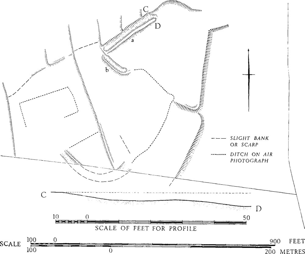
Winterborne Kingston. (22) Settlement on Muston Down
(25) Bowl (84039831) has been dug into in the past. Diam. about 60 ft., ht. 5½ ft.
(26) Bowl (84059833), 30 yds. N.E. of (25), has been severely mutilated by a trench driven through its centre. Diam. 40 ft., ht. 4½ ft.
The North Down Group of five barrows lies at the N. end of the Down, just within the parish boundary and on the spine of a N.E.-S.W. ridge, at about 350 ft. O.D. All the mounds have been heavily ploughed.
(27) Bowl (85109961). Diam. 35 ft., ht. 1½ ft.
(28) Bowl (85189960), 80 yds. E. of (27). Diam. 38 ft., ht. 1½ ft.
(29) Bowl (85159966), 75 yds. N.N.W. of (28) is just visible as a slight rise.
(30) Bowl (85209969), 60 yds. N.E. of (29), is in similar condition.
(31) Bowl (85239972), 45 yds. N.E. of (30), is now a slight rise of less than 1 ft.
Five barrows (32–6) lie on a large spur running N.-S. which forms the W. part of Muston Down. Monument (32) is at 350 ft. O.D. on the spine of the spur; the others are further N. and just W. of the spur top, at over 400 ft. O.D.; they lie in an area of fragmentary 'Celtic' field remains (Group (66)), and have been heavily ploughed.
(32) Bowl (86510011) has now been ploughed down to an indeterminate mound less than 1 ft. high.
(33) Bowl (86550051), 440 yds. N. of (32), lies on a slight S.W. slope. Diam. 42 ft., ht. 3 ft.
(34) Bowl (86530052) adjoins (33) on the N.W. but has now been completely destroyed by ploughing. Air photographs (R.A.F. CPE/UK 1934: 3123–4) clearly show the ditch of this barrow impinging on that of (33). Before total destruction the mound was recorded as 24 ft. in diam. and less than 1 ft. high.
(35) Bowl (86540058), 70 yds. N.N.W. of (33), lies on a gentle W. slope. Diam. about 30 ft., ht. 1½ ft.
(36) Bowl (86560059) is 25 yds. E.N.E. of (35). Diam. 38 ft., ht. 2 ft.
(37) Bowl (87130019) lies on a small spur on the E. side of Muston Down, at about 350 ft. O.D.; the ground falls away to the W. and S. Much ploughed. Diam. 50 ft., ht. 2½ ft.
(38) Bowl (87150019), 25 yds. E. of (37), has been much ploughed. Diam. 50 ft., ht. 2 ft.