An Inventory of the Historical Monuments in Dorset, Volume 4, North. Originally published by Her Majesty's Stationery Office, London, 1972.
This free content was digitised by double rekeying. All rights reserved.
'Tarrant Monkton', in An Inventory of the Historical Monuments in Dorset, Volume 4, North( London, 1972), British History Online https://www.british-history.ac.uk/rchme/dorset/vol4/pp107-110 [accessed 27 July 2024].
'Tarrant Monkton', in An Inventory of the Historical Monuments in Dorset, Volume 4, North( London, 1972), British History Online, accessed July 27, 2024, https://www.british-history.ac.uk/rchme/dorset/vol4/pp107-110.
"Tarrant Monkton". An Inventory of the Historical Monuments in Dorset, Volume 4, North. (London, 1972), , British History Online. Web. 27 July 2024. https://www.british-history.ac.uk/rchme/dorset/vol4/pp107-110.
In this section
29 TARRANT MONKTON (9408)
(O.S. 6 ins., ST 90 NW, ST 90 NE)
Tarrant Monkton, extending to a little over 2,000 acres, comprises a strip of land across the Tarrant valley, entirely on Chalk, at altitudes between 160 ft. and 400 ft. above sea-level. Until late in the 19th century it was combined with Tarrant Launceston. The village, one of the many Domesday Tarrants (V.C.H., Dorset, iii, 74, 83), has grown up on both sides of the Tarrant Brook. The church is the principal monument.
Ecclesiastical
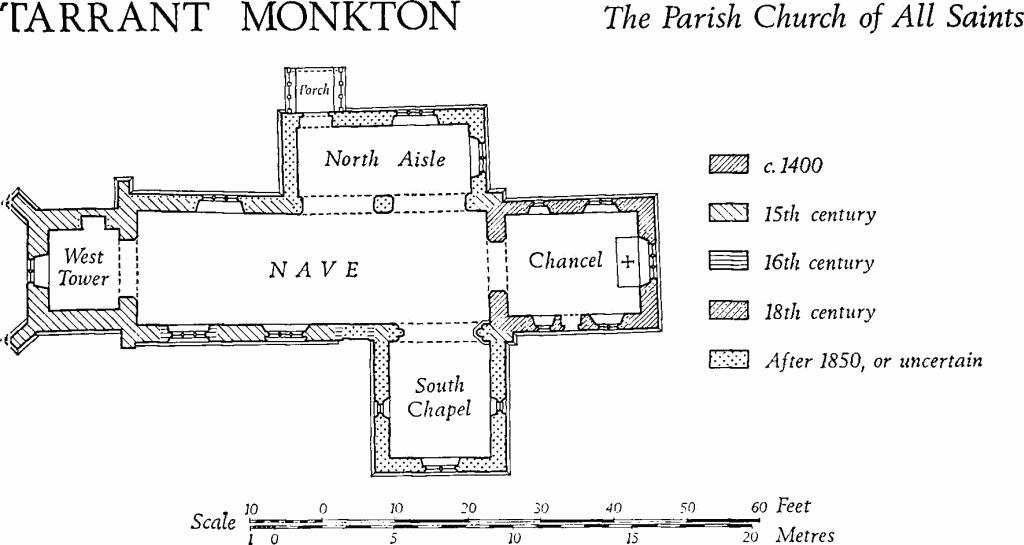
(1) The Parish Church of All Saints, on the W. of the village, has walls of banded ashlar and flint with ashlar dressings, and slated and tiled roofs. The Chancel, of c. 1400 in origin, was extensively restored in the 18th century. The Nave is of the 15th century, with 18th-century alterations; the West Tower also is of the 15th-century, but the upper stage was rebuilt in the 18th century. Hutchins (III, 574) records that the North Aisle formerly had a ceiling dated 1624, but this has gone, probably in the 'restorations' of 1873; the South Chapel and the timber North Porch appear to be of 1873.
Tarrant Monkton, the Parish Church of All Saints
Architectural Description—The Chancel has a plain plinth and an 18th-century E. window of three gradated lancet lights. The N. wall has similar windows of two and of one lancet lights, that on the E. occupying a slightly wider mediaeval opening, the jambs of which are visible externally. The S. wall has windows as in the N. wall and, between them, a restored mediaeval doorway with a chamfered two-centred head, continuous jambs and run-out stops. The original chancel arch is two-centred and of two chamfered orders, the inner order dying into the responds and the outer order continuous. Externally on the E. gable of the nave is the creasing-course of a former chancel roof, slightly higher than the present slate-covered roof. Inside, the chancel has a plain 18th-century plaster barrel-vault and moulded cornices.
The N. side of the Nave has two 19th-century arches to the N. aisle. Further W. the N. wall contains a 19th-century window of three trefoil-headed lights; the external face of the wall was largely restored in the 19th century, but the N.W. corner retains an original 15th-century square-set buttress with a chamfered plinth and three weathered offsets. The S. wall has, on the E., a 19th-century archway to the S. chapel; further W. is a square-headed doorway with a chamfered lintel and jambs, probably of the 16th century, now blocked. Adjacent on the W. is a square-headed 15th-century window of three trefoil-headed lights in a casement-moulded surround, and further W. is a similar window, except that the lights have plain two-centred heads and the surround is hollow-chamfered; this last window probably is of the early 16th century. The S.W. corner of the nave has a square-set buttress of two weathered stages.
The West Tower is of two stages, with chamfered plinths, an 18th-century plat-band between the stages, and a moulded string-course below a plain parapet; the remains of mediaeval gargoyles are reset at the corners of the string-course. In the lower stage the N.W. and S.W. corners have stout diagonal buttresses of two stages with weathered offsets. The tower arch is two-centred, with a plain chamfer on the E. side only, and with continuous jambs. The W. window is of two trefoil-headed lights in a square-headed surround; high in the lower stage is a small square-headed W. light with a chamfered surround. In the upper stage the E. side of the tower has an 18th-century belfry window of two square-headed lights flanked by reset mediaeval label-stops representing a human and a grotesque head. The W. side has a reset 15th-century window of two trefoil-headed lights with a central quatrefoil in a two-centred head with a moulded label. The N. and S. sides have no openings; reset in the S. side is a mediaeval head-stop.
Fittings—Bells: three; 1st by John Danton, with 'Prayse the Lord, 1629, J.D.': 2nd by Clement Tosier, inscribed in Roman capitals 'Thomas Isaacks and John Isaacks churchwardens of the parish of Tarrant Monkton: C.T. cast me in the year of 1694'; 3rd by John Wallis, with 'Feare the Lord I.W. 1610', badly cracked. Font: of Purbeck stone, with tapering square bowl with four round-headed panels on each side, on plain stout centre shaft and four plain corner shafts, and square base; bowl, 12th-century, shafts restored, base modern. Graffito: on S. doorway of chancel, 1757.
Plate: includes silver cup and cover-paten by 'Gillingham' silversmith (Plate 24), cup of usual pattern, cover-paten bowl-shaped and with inscription 'William Dashwood and Robert Tuffin Churchwardens 1607'. Pulpit: of oak, polygonal, four sides with fielded and enriched panelling in two heights, moulded cornice with strapwork frieze, and moulded base, late 17th century. Royal Arms: of George IV, on canvas in wood frame.
Secular
(2) Cross Base (94420887), of stone, probably part of a 14th-century wayside cross, lies some 50 yds. N.E. of the church. It is octagonal, some 4 ft. in diameter, and retains vestiges of a moulded nosing. A central socket is filled with the end of the former shaft, cut off level with the surface of the base and secured in position by lead grouting.
(3) Footbridge (94510904), across the R. Tarrant, of Heathstone ashlar and rubble, has three high segmental arches with chamfered voussoirs. It is probably of the 17th century.
(4) East Farm (946090), house, granary and barn, have walls of brick and of banded brick and flint-work, and thatched and slate-covered roofs. The farmhouse is two-storeyed and comprises a small class-I dwelling, with a larger class-U house added to it on the S. (see Dorset III, lviii). The original building is of the late 18th century; the addition is of c. 1840. A few paces W. of the house is a brick-built granary of c. 1840. Some 30 yds. N.W. is a large barn of 17th-century origin, partly reconstructed in the 18th century; it has brick and flint walls and a thatched roof. Another barn, adjacent on the N., with brick and flint walls and with a tiled roof, dates probably from c. 1700.
(5) Cottage (94480892), of one storey with an attic, has walls of rubble and flint with heavy squared rubble quoins, and a thatched roof; it dates probably from c. 1600. Inside, the plan resembles that of class S, but with the stairs adjacent to the partition between the two ground-floor rooms. The roof rests on stout trusses with cambered collar-beams.
(6) Cottage (94340895), of one storey with an attic, has walls partly of cob, partly of banded brick and flint-work, and partly of timber-framework; the roof is thatched. The building probably is of 17th-century origin and it may formerly have comprised two tenements. Inside, one room has a chamfered beam with shaped stops.
(7) Cottage (94510869), of one storey with an attic, has walls of rubble, flint, brick and cob, and a thatched roof; it probably is of the 17th century. Inside, the plan is of class S, and the plank-and-muntin partition between the two ground-floor rooms is original. The living room has two stop-chamfered beams.
(8) Apple Tree Cottage (94850848), of one storey with an attic, has rendered walls and a thatched roof; it probably is of 17th-century origin. Inside, the class-S plan has been modified by the addition of a room at each end of the range, and by the removal of the original ground-floor partition.
Monuments (9–18)
Unless otherwise described the monuments in this group are of the 18th century and are two-storeyed, with cob walls and thatched roofs.
(9) Inn (94390887), about 30 yds. N. of the church, has walls of brickwork and of banded brick and flint. The S. front has a brick plat-band. Inside, the plan has been much changed and it is possible that the range originally comprised two dwellings.
(10) Cottages (94450887), pair, of one storey with attics, have each a large stop-chamfered beam in the living room.
(11) Cottages (94470889), two adjacent, have been altered and the division between the tenements no longer corresponds with the structural division. The S.W. tenement is single-storeyed with an attic; that on the N.E. is of banded brick and flint and probably is of the 19th century.
(12) Cottage (94430894), of one storey with an attic, is of the early 18th century. The N. room is an addition and the plan was originally of class S. The living room has a stop-chamfered beam.
(13) Cottages (94560909), range of three, are of one storey with attics. The E. tenement has recently been rebuilt.
(14) Cottage (94740873), of one storey with an attic, has a class-S plan. Inside, the original plank partition between the ground-floor rooms is preserved.
(15) House (94750869), formerly single-storeyed and recently heightened to two storeys, has brick walls and a tiled roof.
(16) Bay Farm (94570857), house, with a tiled roof, is of c. 1820. The plan is of class T3 (Dorset II, lxiii), with an additional room at the S. end of the range. Loose in the garden are two late 12th or early 13th-century respond capitals, with volute corners and ovolo-moulded necking bands; their provenance is unknown.
(17) Cottage (94540866), probably with a plan originally of class I or J, but altered.
(18) Cottage (94470878), originally with a class-S plan, was at one time extended at each end and converted into two tenements. Recently, however, the building has been remodelled as one tenement, the two original rooms being combined.
Mediaeval and Later Earthworks
(19) Settlement Remains (947089), on the E. side of High Street, now almost entirely destroyed, comprise seven or more long closes at right-angles to the street, with traces of house platforms at the upper ends (R.A.F., V.A.P., CPE/UK 1934: 5151). Some of the sites still had cottages in the early 19th century (O.S., 1811).
Roman and Prehistoric
(20) Enclosures (938083), perhaps representing an Iron Age or Romano-British settlement, appear as soil-marks on air photographs (C.U.A.P., AQY 91; N.M.R., ST 9308/1, 2; ST 9408/1). At least three subrectangular ditched enclosures, up to 600 ft. by 170 ft., associated with other ditches of uncertain length, occur in an area of about 20 acres; they lie on the summit and on the S. slope of a Chalk spur between 250 ft. and 290 ft. above sea-level.
(21) Dyke, on the S.W. edge of Blandford Camp, runs W.N.W. to E.S.E. (91240755–91410752) for some 200 yds. across the top of a N.-S. Chalk ridge, at over 350 ft. above O.D. The W. end lies in Langton Long Blandford and it has been much disturbed by tracks and roads and by trees growing on it. The bank is 12 ft. across and up to 1½ ft. high with a ditch on its N. side 12 ft. across and 2 ft. deep.
Roman Road from Badbury Rings to Bath, see Dorset V.
Linear Dyke on Luton Down, see Tarrant Keyneston (19).
'Celtic' Fields, see pp. 118–19, Groups (70, 72).
Monuments (22–24), Round Barrows
Three barrows remain, but ten others have been destroyed since 1914 in the construction of Blandford military camp (Dorset Barrows, 136). Three of the destroyed monuments (Dorset Barrows, Nos. 2–4) lay around 914080, in an E.-W. line at the W. end of Monkton Down; two (Nos. 5 and 6) lay on the W. of Pond Bottom Plantation, around 920076, forming a compact group with (23) and (24); five (Nos. 9–13) lay W. of Blackland Plantation, between 929086 and 930081. None of these barrows is known to have been excavated and all references to early excavations in Tarrant Monkton concern barrows in Launceston, which until the 19th century was part of Monkton parish. Certain barrows, however, which were excavated 'on Keynston Down' in 1846, may have been inside the boundary of Monkton (see Tarrant Keyneston, Round Barrows). Air photographs (C.U.A.P., ANC 73, 74) show soil-marks of four ring-ditches, probably the remains of barrows, in a tight cluster at 95480934.
(22) Bowl (91360836), 370 ft. above O.D., lies on top of a broad Chalk ridge in the extreme N.W. of the parish; diam. 50 ft., ht. 6 ft.; surrounding ditch too ill-defined for measurement.
(23) Bowl (92090767), 310 ft. above O.D., lies at the S.E. end of a broad Chalk spur on the W. of Pond Bottom Plantation; diam. 50 ft., ht. 6 ft.; ditch as in (22).
(24) Bowl (92100763), 40 yds. S. of the foregoing; diam. 50 ft., ht. 7½ ft.; ditch as in (22).
Undated
(25) Enclosure (913083), immediately S. of (22), occupies the summit of a flat-topped Chalk ridge, 370 ft. above sea-level. Now largely destroyed, the earthwork formerly was a circle, 450 ft. in diameter, bounded by a low scarp. It may be associated with the race-course formerly on Blandford Down, and probably is of recent date.