An Inventory of the Historical Monuments in Essex, Volume 2, Central and South west. Originally published by His Majesty's Stationery Office, London, 1921.
This free content was digitised by double rekeying. All rights reserved.
'Pleshey', in An Inventory of the Historical Monuments in Essex, Volume 2, Central and South west(London, 1921), British History Online https://www.british-history.ac.uk/rchme/essex/vol2/pp200-203 [accessed 30 April 2025].
'Pleshey', in An Inventory of the Historical Monuments in Essex, Volume 2, Central and South west(London, 1921), British History Online, accessed April 30, 2025, https://www.british-history.ac.uk/rchme/essex/vol2/pp200-203.
"Pleshey". An Inventory of the Historical Monuments in Essex, Volume 2, Central and South west. (London, 1921), British History Online. Web. 30 April 2025. https://www.british-history.ac.uk/rchme/essex/vol2/pp200-203.
In this section
76. PLESHEY. (E.b.)
(O.S. 6 in. xliii. N.W.)
Pleshey is a small parish and village 6 m. N.N.W. of Chelmsford. The Church is interesting and the castle and the town enclosure are particularly large and noteworthy earthworks.
Roman
(1). Foundations, associated with Roman remains, have been observed by the farmer in a field called Stickling or Stitch Field, ½ m. W. of the church on the S. side of the road. A piece of mosaic pavement was found, apparently in the same neighbourhood, in 1749 or 1750, and both then and later, this area has produced Roman burials, coins, etc. Some of the burials may have come from "a vault about three yards square, paved with bricks about 9 in. square, with many earthen pots or bottles with brass stoppers in niches, filled with earth and bones." (MS. notes by Gough, in Salmon's History of Essex, Bodleian Library, MS., Gough, Essex 30; Stukeley, Letters and Diaries, Surtees Soc., II., 165–6; Morant, History of Essex, II. 451.) This structure, the nature of which is not clear from the description, is recorded to have been found about 1780 in the same field. The remains collectively indicate either a farmstead of considerable size, or possibly a small village settlement. (See Sectional Preface, p. xxix.).
Ecclesiastical
(2). Parish Church of Holy Trinity stands on the S.W. side of the village. The church was almost entirely re-built in the 18th century, and again in 1868; but the N.,S. and W. arches of the Central Tower and probably the foundations of the North and South Transepts are of c. 1400.
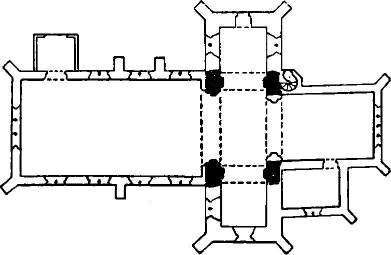
The Church, Plan
The church is of note for its cruciform plan, its connection with the college of nine priests, founded by Thomas of Woodstock, Duke of Gloucester, in 1393, its bells of that date, and the remains of important altar-tombs.
The Central Tower (12 ft. by 20 ft.) has a modern E. arch. The N. arch, of c. 1400, is of two chamfered orders; the outer dies into the wall, the inner is carried down on each side to a semi-octagonal corbel with a moulded capital. The S. arch and corbels are uniform with those on the N. The W. arch is two-centred and of two chamfered orders, the outer continuous, the inner resting on semi-octagonal responds with moulded capitals partly restored; on the W. face is an outer order at a higher level.
Fittings—Bells: five; 1st by Miles Graye, 1620; 2nd and 4th by William Dawe, c. 1400, 2nd inscribed "Dicor ego Thomas Christi Laus Est Sonus Omas," the words punctured by medallions representing two birds on a plant with the inscription "William Foundor me fecit"; 4th inscribed "Ora Mente Pia Pro Nobis Virgo Maria," with similar medallions. Brass Indents (see Monuments). Chest: In vestry—hutch chest panelled, c. 1600. Communion Table: In chancel—(1) with square panelled legs with jewel ornament, top rail with rich arabesque ornament and inlay, early 17th-century, top modern. In vestry—(2) with turned legs and shaped brackets, late 17th-century. Font: bowl supposed to be of former old font is now in the garden of Langley's, Great Waltham. (8). Monuments: In nave—in N.E. corner, (1) now upright against wall, top of altar-tomb with moulded edges and indents of a bareheaded man in armour and a priest; between them a pillar; above and below the knight a shield, above the priest a chalice, below him a scroll, c. 1480–90; in S.E. corner (2) now upright against wall, probably of Humphrey Stafford, K.G., Duke of Buckingham, 1460 and Anne, his wife, 1480, top of altar-tomb with moulded edges, and indents of marginal inscription plate and of two figures under a double canopy and super-canopy; the male figure wears a long cloak, perhaps of the Garter, and his head rests on a helmet apparently with a swan crest.
Condition—Good, re-built.
Secular
(3). Pleshey Castle (Mount and Bailey and Town Enclosure) (Plan p. 202), N.E. of the church, is situated on fairly high ground, which slopes away to the N. and E.
The work is worthy of note as a good example of the mount and bailey type of earthwork, with an unusually well-preserved town enclosure or 'burgus' attached.
The Castle is ascribed to the De Mandevilles in the 12th century.
The plan consists of a steep, oval-shaped mount surrounded by a wide moat, a strong inner bailey on the S., and slight traces of another bailey to the N. To the N. are also well-defined remains of the town enclosure.
The Mount, 55 ft. high from the water's edge, is 280 ft. by 295 ft. in diameter at the base, and 135 ft. by 95 ft. at the summit. The surrounding moat is about 70 ft. wide across the water at the widest part, but is now dry on the S. side. Upon the summit of the mount are traces of the flint-rubble walls of the Keep, and fragments of brick foundations of later buildings. The original entrance from the S. bailey to the mount was on the S.W. side, and is now marked by two parallel walls of flint-rubble on the slope of the mount. A fine single span bridge brick (Plate p. 202) of 15th-century date, with a two-centred arch, now crosses the moat at this point.
The inner bailey, to the S. of the mount, encloses about 2¼ acres, and is defended by a strong inner rampart and moat, the latter now dry except on the S. side, and connected with the moat of the mount at both ends. The rampart is about 16ft. above the interior level at the strongest point and the ditch is 100 ft. wide from crest to crest, and 37 ft. deep from the crest of the rampart. At the S.W. corner is an original entrance, having on the N.W. side a fragment of flint-rubble, and at the base, a short length of faced rubble with a plinth. There is a second entrance, probably modern, at the S.E. corner. In the moat at the N.E. corner is a small island, and the moat is considerably wider at this point.
Of the bailey to the north of the mount only a short length of rampart and ditch remains, running from the S.E. junction of the moats of the mount and inner bailey in a northerly direction. The curved line of Back Lane may mark approximately the extent of the bailey on this side.
The town enclosure to the N. was defended by a rampart and ditch, roughly conforming with the plan of the N. bailey, but now much denuded. The first definite section of it is to be found immediately N. of the road opposite the church, and it continues in a northerly direction to a slight bend in the road to Whitehall, where it veers round in a S.E. direction and crosses the main road E. of Mount House. From this point the defences become stronger, the ditch being 45 ft. wide from crest to crest, and 11 ft. deep from the top of the rampart, until they join the moat of the S. bailey at the N.E. corner.
A short section of dry ditch, running from the junction of the mount and S. bailey towards the S. of Mount House, may have been part of the town ditch, in which case the defences on this side would have been double.
The original church is said to have stood within this enclosure, but the present church and the site of the priests' college, founded by the Duke of Gloucester late in the 14th century, are outside the defences.
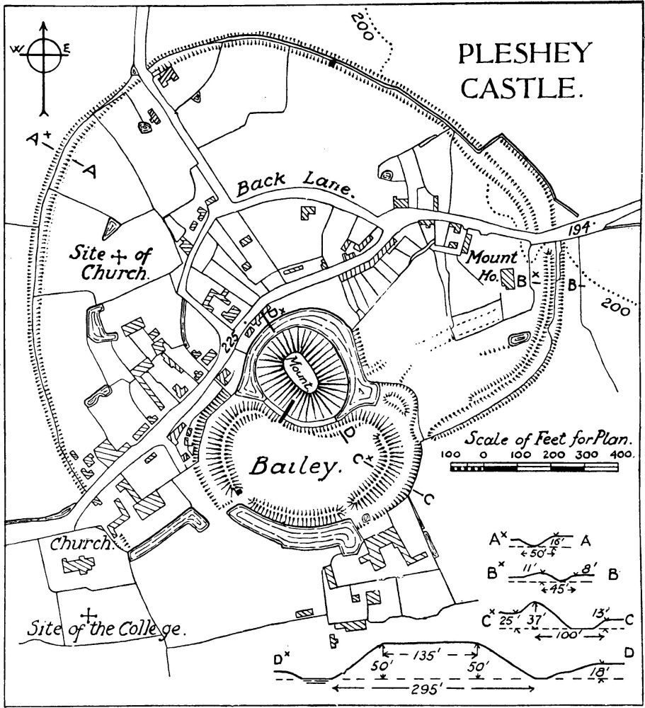
Pleshey Castle.
By the side of a stream about ½ m. S. of the castle is a disused mill dam, probably the site of the castle mill.
Condition—Of castle, good.
(4). Inscribed Stone, set in garden wall at Mount House, 500 yards N.E. of the church. The stone has a black-letter inscription, "Ricardus rex ii."
(5). House, now Post Office, on the S.E. side of the main street, 170 yards N.E. of the church, is of two storeys, timber-framed and plastered; the roofs are tiled. It was built in the 17th century on an L-shaped plan with the wings extending towards the N.E. and S.E. There are modern additions between the wings.
Condition—Good.
(6). Cottage, on the N.W. side of the main street, 250 yards N.E. of the church, is of two storeys, timber-framed and plastered; the roofs are thatched. It was built late in the 17th or early in the 18th century.
Condition—Good.
(7). Plesheybury, house, outbuildings and fishpond, ⅓ m. W. of the church. The House is of two storeys, timber-framed and plastered; the roofs are tiled. It was built probably in the 16th century with cross-wings at the E. and W. ends. On the N. front the upper storey projects at the ends of the cross-wings. Inside the building are some original ceiling-beams and two old battened doors.
The Granary is of two storeys, with walls of brick and timber; the Barn is of five bays, timber-framed and weather-boarded. Both buildings are of the 17th century.
The Fishpond lies W. of the house.
Condition—Of house, good.
(8). Cottage, in grounds of the 'Retreat,' and 130 yards N.E. of the church, is of two storeys, timber-framed and plastered; the roofs are thatched. It was built in the 17th century and has exposed ceiling-beams and timber-framing.
Condition—Good.