An Inventory of the Historical Monuments in Herefordshire, Volume 2, East. Originally published by His Majesty's Stationery Office, London, 1932.
This free content was digitised by double rekeying. All rights reserved.
'Lugwardine', in An Inventory of the Historical Monuments in Herefordshire, Volume 2, East(London, 1932), British History Online https://www.british-history.ac.uk/rchme/heref/vol2/pp122-127 [accessed 30 April 2025].
'Lugwardine', in An Inventory of the Historical Monuments in Herefordshire, Volume 2, East(London, 1932), British History Online, accessed April 30, 2025, https://www.british-history.ac.uk/rchme/heref/vol2/pp122-127.
"Lugwardine". An Inventory of the Historical Monuments in Herefordshire, Volume 2, East. (London, 1932), British History Online. Web. 30 April 2025. https://www.british-history.ac.uk/rchme/heref/vol2/pp122-127.
In this section
51 LUGWARDINE (B.d.)
(O.S. 6 in. XXXIV, S.W.)
Lugwardine is a parish 2 m. N.E. of Hereford. The church and Lugg Bridge, which dates from the 14th century, are the principal monuments.
Ecclesiastical
(1). Parish Church of St. Peter stands near the middle of the parish. The walls are of local sandstone rubble with ashlar and dressings of the same material; the roofs are tiled. The history of the building has been much obscured by modern restoration but a 12th-century window re-set in the S. aisle, but probably once in the Nave, indicates a building of this date. A N. tower was added to the nave probably in the 13th century and the Chancel seems to have been re-built late in the same century; the South Transept was added at the same time or perhaps a little later. The West Tower was built late in the 14th or early in the 15th century, when the N. tower was probably pulled down except the ground stage which became the North Transept. The North and South Aisles were added early in the 19th century, and the church was restored in 1872, when the W. walls of both transepts were removed, the chancel heightened and partly re-built and the transept-arches re-built. The S. transept was restored in 1885. The North Vestry and the South Chapel are modern.

Lugwardine, the Parish Church of St Peter
Architectural Description—The Chancel (29 ft. by 14¾ ft.) has a modern E. window. In the N. wall are four partly restored and probably heightened late 13th-century windows each of a single trefoiled light. In the S. wall is a similar window, and farther W. a modern arcade of two bays. The chancel-arch is modern.
The Nave (42½ ft. by 20½ ft.) has modern N. and S. arcades of three bays; the eastern arch, on each side, incorporates re-cut old voussoirs probably of the late 13th or early 14th-century arches to the transepts.
The North Transept (16 ft. by 15½ ft.) has, in the E. wall, a late 13th or early 14th-century recess with chamfered jambs and two-centred arch; in it is a modern doorway. In the N. wall is a late 14th-century window, modern externally, and of three trefoiled ogee lights with vertical tracery in a two-centred head, with a higher segmental-pointed rear-arch. In the W. wall is a modern arcade of two bays.
The South Transept (18½ ft. by 15¾ ft.) appears to have been very largely re-built above the plinth.
The South Aisle is modern but incorporates much old material, and re-set in the W. wall is a small 12th-century window of one round-headed light.
The West Tower (13 ft. square) is of late 14th or early 15th-century date and of three stages, ashlar-faced with a moulded plinth and embattled parapet with carved grotesque gargoyles. The two-centred tower-arch is of two continuous orders, the inner moulded and the outer hollow-chamfered. The W. doorway has a four-centred arch in a square head with cusped spandrels; the W. window is of three trefoiled lights with vertical tracery in a two-centred head; both doorway and window are set in a deep recess with casement-moulded reveals and a decayed label. The second stage has, in the N. and S. walls, a window of one trefoiled light. The bell-chamber has, in each wall, a window of two trefoiled ogee lights with a quatrefoil in a two-centred head; the reveals are casement-moulded.
The Roof of the nave is of trussed-rafter type and probably of mediæval date.
Fittings—Bells: eight; 5th by John Green of Worcester, 1651, inscription reversed; 6th probably by the Worcester foundry, early 15th-century and inscribed in Lombardic capitals, "In multis annis resonet campana Johannis"; 8th by John Finch, 1632. Brass: See Monument (2). Chest: In second stage of tower—boarded chest of hutch-type with initials and date A.W., IL., 1702, strap-hinges and three locks. Churchyard Cross: S. of chancel—square to octagonal base on three modern steps, 14th or 15th-century, shaft and head modern. Monuments: In S. transept—on S. wall, (1) to John Best, S.T.D., Canon of Hereford and vicar, 1637, tablet (Plate 154), of slate and alabaster with side pilasters and cornice surmounted by coloured bust of man with surplice, doctor's hood, ruff, etc., holding book. In S. aisle—on W. wall, (2) to Jane, wife successively of Robert Kirle and John Best, 1622, wooden tablet (Plate 154) with Doric side-columns supporting entablature and cresting, brass plate with inscription and figure of woman kneeling in a church. In tower—against S. wall, (3) of William Reed, sheriff and J.P., 1634, freestone monument (Plate 153) with base, effigy and canopy; base with pilasters and kneeling figures of two sons and two daughters; reclining effigy in civil costume and high boots; flat canopy supported by Corinthian columns with quatre-foiled panels on the soffit, achievement and eight shields-of-arms. Piscinæ: In chancel—re-set recess with ogee head and projecting moulded drain, probably 14th-century. In S. transept—in S. wall, recess with trefoiled head and round drain, probably late 13th-century. Plate: includes a cup, without date-letter, but inscribed R. and A. R., 1673, and a cover-paten of 1709 given by Judith Wotton. Screen: Under tower-arch—apparently modern but incorporating a number of trefoiled and sub-cuspedtraceried heads of fights of two varieties, 15th or early 16th-century.
Condition—Good, much restored.
Secular
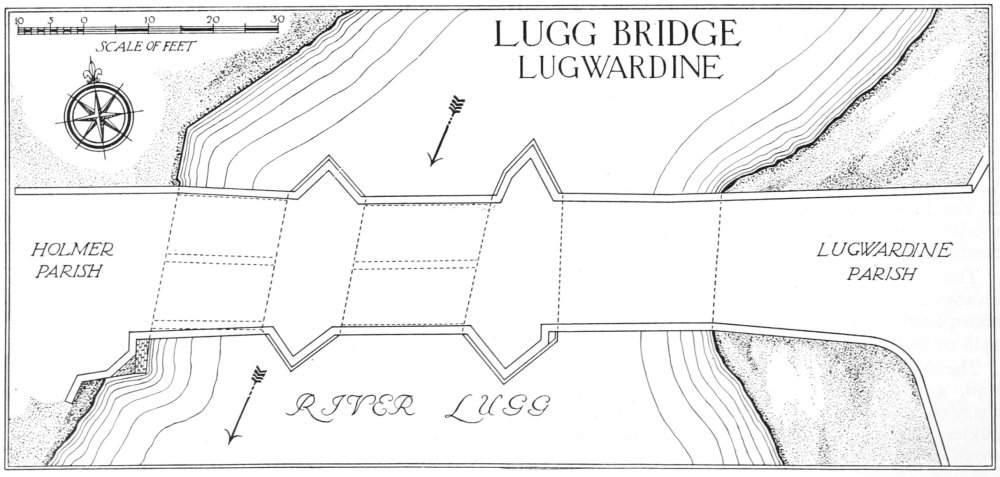
(2). Lugg Bridge (Plate 155), crossing the river Lugg between the parishes of Lugwardine and Holmer and 1¼ m. W.N.W. of Lugwardine church, is of stone and of three spans. It was built probably in the 14th century and repairs are mentioned in the Hereford episcopal registers in 1409 and 1464. The W. arch is probably original and the E. arch perhaps dates from the 15th century; the middle arch is apparently of 14th-century material, reconstructed or repaired at some uncertain date. The bridge has been repaired in recent years and the parapets reconstructed. The piers have cutwaters both up and down stream. The two W. arches have each three square ribs on the soffit; the middle arch is round and the W. arch pointed, but both have joggled voussoirs, the stones being cut to fit each other with a wavy curve; the joggling is absent from the springers of both arches and some plain voussoirs have been introduced elsewhere in the middle arch, indicating some repair or reconstruction. The E. arch is pointed but has no ribs on the soffit and no joggling. The roadway has been widened on the S. side, above the W. arch, the addition being carried on an outer ring or order of the arch.
Condition—Good.
(3). Lugwardine Bridge, crossing the river Lugg, 650 yards S.W. of the church, is of stone and of three spans. It is mentioned as existing in the Quarter Sessions Records in 1690 and may perhaps be assigned to the early part of the 17th century. The bridge was widened on the W. side by about 9 ft. in 1824 and the parapets on both sides are of that date. The three arches are of plain segmental form and the piers retain their original cutwaters on the E. or down-stream side. The N. arch appears to have been re-built at some date before the widening.
Condition—Good.
Lugg Bridge, Lugwardine

Lugwardine, Plan Showing the Position of Monuments
(4). Homestead Moat, S.W. of Old Court and 200 yards N.N.W. of the church, has been partly filled in on the N. side. There are traces of foundationtrenches in the S.E. angle of the enclosure.
(5). Old Longworth, house and moat, 1¼ m. S.S.E. of the church. The House, now two tenements, is of two storeys; the walls are of stone and the roofs are tiled. It has been largely re-built in modern times but incorporates some old materials and possibly part of a 17th-century building. The private chapel formerly standing near the house has been taken down and the materials re-erected at Bartestree Convent (see Bartestree (2)).
The Moat, formerly surrounding the house, is now fragmentary.
Condition—Of house, good.
(6). Walling, forming the W. boundary of Lugwardine Court and on the E. side of the road 500 yards S.S.W. of the church, is of rubble and about 100 yards in length. It is probably of 16th or 17th-century date and has one ashlar-faced buttress and other later buttresses.
Condition—Good.
(7). Rock Farm, house, 180 yards S.E. of the church, is of two storeys, timber-framed and with tiled roofs. It was built late in the 16th or early in the 17th-century and is of T-shaped plan with the cross-wing at the E. end. The house has been little altered and all the timber-framing is exposed. The main chimney-stack has three square shafts set diagonally. Inside the building some of the timber-framing and ceiling-beams are exposed. Between the two wings is a broad passage-way on the lines of a 'screens' passage.
Condition—Good.
Monuments (8–31)
The following monuments, unless otherwise described, are of the 17th century and of two storeys; the walls are timber-framed and the roofs are tile or slate-covered. Most of the buildings have exposed external timber-framing and internal ceiling-beams.
Condition—Good or fairly good, unless noted.
(8). The Rock, house, 140 yards S.S.E. of the church, is modern except for a long low range on the N.E. side, containing offices, etc.
(9). Cottage, two tenements, immediately S. of the churchyard, has been largely re-faced in brick.
(10). Old Vicarage, house, S.W. of the church, is modern except for the chimney-stack of c. 1600, with three diagonal shafts in brick. Re-set in the modern vicarage is some early 17th-century panelling with a fluted frieze, which was removed from this house.
(11). New Rents Farm, house, 120 yards W.N.W. of the church, has a thatched roof.
(12). Outbuilding, on the N. side of the road, 120 yards, W.S.W. of (11), was built late in the 17th or early in the 18th century.
(13). Crown and Anchor Inn, 370 yards W. of the church, has large 18th-century and modern additions.
(14). House, 110 yards W.N.W. of (13), has been much modernised.
(15). Lodge, two tenements, on the S. side of the road, 300 yards W.S.W. of the church, has a thatched roof.
(16). House, to the N.W. of the road, ¼ m. W.S.W. of the church, contains an original moulded ceiling-beam.
(17). High House, two tenements, on the W. side of the road, 50 yards S. of (16), is of T-shaped plan with the cross-wing at the E. end.
(18). Barn, on the W. side of the road, 250 yards N. of the church, is of three bays, weather-boarded.
Condition—Bad.
(19). Sunnybank, cottage, on the N. side of the road, ¼ m. N. of the church, has been partly re-fronted in brick.
(20). Range of cottages and barn, on the N. side of the road, 130 yards S.W. of (19), has a thatched roof.
(21). Cottage, immediately W. of (20), has a thatched roof.
(22). Cottage, two tenements, 20 yards W. of (21), has a thatched roof.
(23). Cottage, 180 yards E.S.E. of the church, has a thatched roof and an original chimney-stack of stone with offsets.
(24). Cottage, on the S. side of the road, 540 yards E. of the church.
(25). Cottage and shop, on the N. side of the road, 50 yards N.E. of (24), has a thatched roof. Inside the building is an original moulded ceiling-beam.
(26). Rose Cottage, on the N. side of the road, ½ m. E.N.E. of the church, has a thatched roof.
(27). Forge Cottage, on the S. side of the road, 460 yards E.N.E. of (26), has a thatched roof.
(28). Hagley Hall, house, 60 yards E.N.E. of (27), was altered, re-fronted in brick and the roof re-built c. 1800.
(29). Pump House, two tenements, on the W. side of the road, 1,600 yards E.N.E. of the church, has a cross-wing at the N. end and a thatched roof.
(30). Cottage, on the W. side of the road, 640 yards S.S.E. of the church, has a thatched roof.
(31). Sundial Cottage, on the E. side of the road, 1,100 yards S.S.E. of the church, has a thatched roof.
Unclassified
(32). Embanked Enclosure in the S. angle between the rivers Lugg and Frome, about 1½ m. S.E. of the church. An irregular area of about 100 acres is enclosed by a bank, 12 ft. wide and 3 ft. high, with a ditch about 12 ft. wide on each side. The bank has been destroyed in places and the ditches largely filled in.
Condition—Poor.