An Inventory of the Historical Monuments in Herefordshire, Volume 2, East. Originally published by His Majesty's Stationery Office, London, 1932.
This free content was digitised by double rekeying. All rights reserved.
'Colwall', in An Inventory of the Historical Monuments in Herefordshire, Volume 2, East, (London, 1932) pp. 52-57. British History Online https://www.british-history.ac.uk/rchme/heref/vol2/pp52-57 [accessed 26 April 2024]
In this section
23 COLWALL (E.c.)
(O.S. 6 in. (a)XXXVI, N.W., (b)XXXVI, S.W.)
Colwall is a parish on the E. border of the county and on the W. side of the Malvern Hills, 3½ m. N.E. of Ledbury. The church, Park Farm, Old Colwall, and the camp on the Herefordshire Beacon are the principal monuments.
Ecclesiastical
a(1). Parish Church of St. James (Plate 115) stands in the W. half of the parish. The walls are of local sandstone and shale, with sandstone dressings; the roofs are covered with tiles. The S. doorway and a few re-used stones indicate the existence of a 12th-century church, but its precise form and size are uncertain. The S. arcade of the Nave is of mid to late 13th-century date, the three eastern bays being slightly earlier than the rest; the South Aisle was added at the same time. The South Tower was added about the middle of the 14th century, the bell-chamber being built late in the same century. The South Porch was added probably in the 16th century. The church was restored in 1865–6 when the Chancel was re-built, and again in 1880 when the N. arcade was built and the North Aisle added.
The detail of the S. arcade is of interest.
Architectural Description—The Nave (57½ ft. by 19½ ft.) has a modern N. arcade. The mid to late 13th-century S. arcade is of five bays with two-centred arches of two chamfered orders, struck from below the springing-line; the columns are cylindrical with moulded bases and capitals and half-columns as responds; the capital (Plate 17) of the third column is carved with the heads of two men and two women with foliage between; the fourth capital has 'stiff-leaf' foliage; the capital of the W. respond (Plate 17) is carved with a woman's bust and two pairs of heads. In the W. wall is a doorway, probably of 14th-century date and with chamfered jambs and modern head; above it is a late 14th or early 15th-century window of three trefoiled lights with tracery in a two-centred head. There is a length of straight joint between the nave and the S. aisle.
The North Aisle is modern but incorporates two mid 14th-century windows, re-set, and each of two trefoiled ogee lights with a quatrefoil in a two-centred head.
The South Aisle (11½ ft. wide) has, in the E. wall, a 13th-century lancet-window. In the S. wall are two windows, the eastern of c. 1300 and of two cinque-foiled lights in a two-centred head, and the western of two pointed lights in a square head, probably of the same date but with a later head of a pointed window cut down and re-set; the re-set late 12th-century S. doorway (Plate 114) has a round arch of two orders, the outer chamfered and the inner moulded; the jambs have a rounded inner order and a detached shaft with moulded base, scalloped capital and moulded abacus continued round the inner order; farther W. is a modern doorway. In the W. wall is a 13th-century lancet-window.
The South Tower (14 ft. square) is of three stages with an embattled parapet. The two lower stages are of mid 14th-century date, and the bell-chamber was added late in the same century. In the E. wall of the ground-stage is a large doorway, with jambs and two-centred arch of two chamfered orders; it is now fitted as a window; in the S. wall is a modern loop. The second stage has a loop in the E., S. and W. walls. The bell-chamber has, in each wall, a window of two trefoiled lights with a quatrefoil in a two-centred head.
The South Porch is probably of the 16th century and is timber-framed on dwarf walls. The outer entrance has side posts and an ogee arched head under the tie-beam of the gable; flanking the entrance are openings, each with a diamond-shaped mullion. The E. side has nine similar mullions. The roof is plastered.
The Roof of the nave (Plate 19) is of the 14th century and of five bays with curved braces below the collar-beams; there are two ranges of wind-braces, the upper forming pointed and the lower sex-foiled arches; there is an added tie-beam with the initials and date R.M., R.C., 1675. The W. part of the roof of the S. aisle is also of the 14th century and has two braced collar-beam trusses; the E. part of the roof is boarded.
Fittings—Brass: In S. aisle—on S. wall, to Elisabeth, wife of Anthony Harford, 1590, rectangular plate with figure of man in armour and six sons, and wife with four daughters, achievement and two shields-of-arms. Chest: In S. aisle—panelled front with enriched styles, early 17th-century. Churchyard Cross: stump of octagonal shaft in square base; niche in W. face, with remains of pinnacles and finial, three square steps, 15th-century. Font: plain hemispherical bowl, cylindrical stem and chamfered base, perhaps 13th century, entirely re-cut. Glass: In N. aisle—in N.E. window, foliated roundel, 14th or 15th-century; in third window, similar roundel and fragments, 14th-century. In S. aisle—in E. window, various fragments; in second window in S. wall, roundel and fragments, 14th or 15th-century. Monuments and Floor-slabs. Monuments: In S. aisle—on E. wail, (1) to [John] Walweyn, 1587, stone tablet with border, cornice achievement-of-arms and the initials and names I.W., Walweyn and Rudhale. In churchyard—E. of chancel, (2) to John Hartland, 1681, enriched table-tomb; S.E. of S. aisle, (3) to Jone Gilding, 1713, head-stone; (4) to Elizabeth James, 1706, head-stone; S.E. of chancel, (5) to Elizabeth Goodman, 1711–12, head-stone. Floor-slabs: In N. aisle—(1) slab with remains of foliated cross, 14th-century. In S. aisle—(2) to [John] Walwyn, 1587. (See Monument (1)); (3) to William Hall, Jun., 1676; (4) to William Hall, 167– and Joane his widow, 167–. Niche: On E. wall of tower— rough recesses in the form of a triple niche with round heads, date uncertain. Pavement: In N. aisle—in N. wall, round slip-tile with labourers digging, 14th-century; on sill of second N. window, fragments of slip-tiles including arms (a cross paty between four martlets), 14th-century. Pulpit (Plate 134): hexagonal, panelled in two heights with enriched rails and posts with baluster-ornament, frieze with marquetry work, lower panels with lozenges and rosettes and upper panels with enriched arch in each panel; similar panel on standard of sounding-board; sounding-board with turned pendants at angles, enriched fascias, cornice and cresting, late 16th or early 17th-century. Miscellanea: Incorporated in N. wall of N. aisle, stone fragment with 12th-century diapered ornament.
Condition—Good.
Secular
b(2). Homestead Moat, at Cummins Farm, ¾ m. S. of the church, formed a four-sided enclosure and is much obliterated on the S.
a(3). Brockbury, house, outbuilding, and moat, 850 yards S.E. of the church. The House is of two storeys with attics. The walls are of brick and the roofs are tiled. It was built in 1698 over the cellars of an older house, and was originally timber-framed; the front was refaced in brick in or about 1738, retaining the old framing and windows; the back has been cased in modern times. The front and sides have original windows with solid frame, mullion and transom; the roof is hipped. Inside the building there are a number of early 18th-century panelled doors and one of early 17th-century panelling. In the S.E. room is an alcove with a shell-head, cherub-head and key-block. The original staircase has turned balusters and square newels with moulded cappings.
The Outbuilding, N.W. of the house, has been partly re-faced in brick.
The Moat or enclosure lies 115 yards N.N.E. of the house, and is of roughly triangular form. There is a system of ditches, etc. extending to the E. and W.
Condition—Of house, good.
b(4). Oldcastle Farm, house and pond, nearly 1½ m. S.E. of the church. The House is of two storeys with attics; the walls are of timber-framing, brick and stone, and the roofs are tiled. It was built early in the 17th century and remodelled early in the 18th century. Some of the timber-framing is exposed. The entrance doorway has a late 17th or early 18th-century hood with pediment resting on carved consoles. Inside the building are some exposed ceiling-beams and some early 18th-century panelled doors. The late 17th-century staircase has moulded strings, turned balusters and square newels.
The Pond, N. of the house, was originally a moat, the island having been removed in recent years.
Condition—Of house, good.
a(5). Park Farm (Plate 23), house, 80 yards N.W. of the church, is of two storeys, timber-framed and with tiled roofs. It is of rectangular plan with three parallel roofs, running E. and W. The N. block is earlier than the rest and dates probably from the beginning of the 16th century; the rest is an addition of late in the same century. The S. front has been re-faced in brick.
The house is a good example of timber-framing.
The W. front has exposed timber-framing and is of three gabled bays. The framing of the N. bay is closer set than the rest, except in the gable, which has probably been reconstructed. The gables have moulded bargeboards and moulded pendants. The ground floor has a shallow bay-window of four lights with moulded frame, mullions, transom and cornice; the first floor has two similar bay-windows. The W. front has similar gables and framing except that the earlier N. gable retains its original herring-bone framing. The N. front retains its original close-set framing, and has a bay-window similar to those on the W. front. Inside the building, the original part has heavy chamfered beams. In the later part are moulded ceiling-beams and some 17th-century panelling.
Condition—Fairly good, except N. range.
a(6). Old Colwall, house, 1,030 yards W.S.W. of the church, is of three storeys; the walls are of brick and the roofs are tiled. It was built probably early in the 18th century and has a symmetrically designed front with three ranges of sash-windows. Inside the building, the fittings are mainly of later 18th-century date, but the staircase (Plate 75) is original and has moulded strings, twisted balusters and square newels. The S.W. room has exposed ceiling-beams. The garden, N. of the house, has old brick enclosing walls. On the W. side are brick piers with ball-terminals.
Condition—Good.
a(7). Joyces, house, nearly ¾ m. E.S.E. of the church, is of two storeys; the walls are of timber-framing and brick, and the roofs are tiled. It was built in the 17th century and extended to the S. in the 18th century, and an E. wing added Some of the timber-framing is exposed. Inside the building, some ceiling-beams are exposed and there is a little original panelling. Two panelled doors date from early in the 18th century.
Condition—Good.
a(8). Brook House, about ¾ m. E. of the church, is of two storeys with attics; the walls are timber-framed and the roofs are tiled. It was built early in the 17th century on an irregular plan, and has been extended on the N.E., S.E. and S.W. in modern times. The timber-framing is mostly exposed. Inside the building are some exposed ceiling-beams. The late 17th-century staircase has moulded strings, wavy slatbalusters and square newels.
Condition—Good.
b(9). Brand Lodge, 1¾ m. E.S.E. of the church, is modern, but built into the terrace-walls of the garden are two late 16th-century carved stone panels and a figure of the same date. The panels have scrolled ornament and figures of Justice and (possibly) Plenty; the single figure represents Ceres.
b(10). Dovehouse and barn at Barton Court, nearly 1 m. S. of the church. The Dovehouse (Plate 36) is a round stone building with a pyramidal tiled roof capped by a wooden cote. The building is perhaps of mediæval date, but the roof is of the 17th or 18th century. Inside the building are 16 tiers of nests. The Barn is weather-boarded. The five S.W. bays are probably of early 18th-century date.
Condition—Good.
Monuments (11–33)
The following monuments, unless otherwise described, are of the 17th century and of two storeys; the walls are timber-framed and the roofs are tile or slate-covered. Most of the buildings have exposed external timber-framing and ceiling-beams, and some have original chimney-stacks.
Condition—Good or fairly good.
a(11). Barn, on the W. side of the road, 600 yards N.N.W. of (10), is of one storey and probably of early 18th-century date.
a(12). Moorcroft Farm, house, 720 yards W. of the church, has been much altered.
a(13). Cottage (Plate 33), on the E. side of the churchyard, has a thatched roof.
a(14). Lugg's Mill Farm, house, 530 yards E.N.E. of the church, has an early 18th-century addition on the N. The roof of the older part is thatched.
a(15). Mapleton (formerly the Sly House), house, ½ m. E.N.E. of the church, was built probably early in the 18th century. The cross-wing at the E. end is a later addition.
a(16). Cottage, 25 yards S. of (15), was built probably early in the 18th century.
a(17). Upper Grovesend (formerly Grubend), house, on the N. side of the road, nearly 1 m. E.N.E. of the church. Some of the windows are of early 18th-century date.
a(18). Stamp Cottages, 150 yards W.N.W. of (17), have a thatched roof.
a(19). Grovesend Farm, house, 80 yards S.W. of (17), has been almost completely altered or re-built.
a(20). Pink's Cottages, three tenements, on the S. side of the road, nearly 1¼ m. E.N.E. of the church, were built early in the 18th century and have a thatched roof.
a(21). Cowlbarn Farm, house, nearly 1¼ m. E.N.E. of the church, has modern additions at both ends.
a(22). Brockhill Farm, house, over 1¼ m. N.E. of the church, was built late in the 17th or early in the 18th century and has later additions on the S. side.
a(23). Cottage, 100 yards N.W. of the Railway Station, has a cross-wing at the N.E. end. It has been considerably altered and modernized.
a(24). Cottage, on the N.W. side of the road, 350 yards W. of the Railway Station, was built early in the 18th century and has a thatched roof.
a(25). Highgate, cottage on the S.E. side of the road, 150 yards S.S.E. of (24).
a(26). Cottage, on the S.E. side of the railway-line, ¾ m. E.S.E. of the church, was built probably early in the 18th century.
b(27). Cottage, S.W. of Colwall Green and 1,550 yards S.E. of the church, was built probably early in the 18th century and has a later extension on the S.E.
b(28). Barton Cottages, two cottages, 50 yards S. of (27), have thatched roofs.
b(29). Cottage, on the N. side of the road at Evendine, 1¼ m. E.S.E. of the church, has a thatched roof.
b(30). Hartland's Cottages, 30 yards E. of (29), were built late in the 17th or early in the 18th century. Part of the roof is thatched.
b(31). Cottage, N. of the road and 180 yards N.E. of (30), has a thatched roof.
b(32). Malthouse Farm, house on the S. side of the road, 120 yards E.S.E. of (31), has an added S. wing and extensions to the E. and W., all of 18th-century or later date.
b(33). House, 40 yards E. of (32), was originally of L-shaped plan with the wings extending towards the N. and W. An E. wing was added in the 18th century, making the plan Z-shaped. The S.W. room has 18th-century plaster panelling and ceiling. In the middle block are two original shaped brackets.
Unclassified
b(34). Herefordshire Beacon Camp (1,114 ft.) (Plates 116–118) occupies the summit of that portion of the Malvern Hills immediately S. of the Pass through the hills at Wynds Point, and is 2 m. S.E. of Colwall church. It covers an area of about 32 acres and is of irregular form, generally following the contours. It is entirely surrounded by a ditch with outer rampart, formed by the throwing outwards of the spoil down the hillside, and an inner scarp of great height which, in some places, is further strengthened by a slight inner rampart. Above the inner scarp the natural hillside has been cut, where necessary, to form a berm or walk. There are four entrances. The one to the W. side of the southern part of the camp is approached by a curving trackway with outer rampart while the inner rampart is turned slightly inwards on either side of the entrance. The second entrance is at the re-entrant of the angle formed by the enclosure on the E. side, where there are traces of an inner rampart, immediately S. of the causeway over the ditch. The third is at the most southerly point of the camp, where there is a causeway and inner rampart, while the fourth is some 70 yards S.S.E. of the most northerly point, and, though this has been much destroyed, there are traces of a slight inner ditch immediately N. of this entrance along which the approach probably led, and not, as now, directly into the camp.
Within the enclosure—which consists of a roughly circular hilltop with two lower projecting spurs running respectively N.N.E. and S.—an inner stronghold has been formed which is defended in part by the outer camp defences, from the more northerly spur by a ditch with outer rampart, and from the southern by a series of terraces.
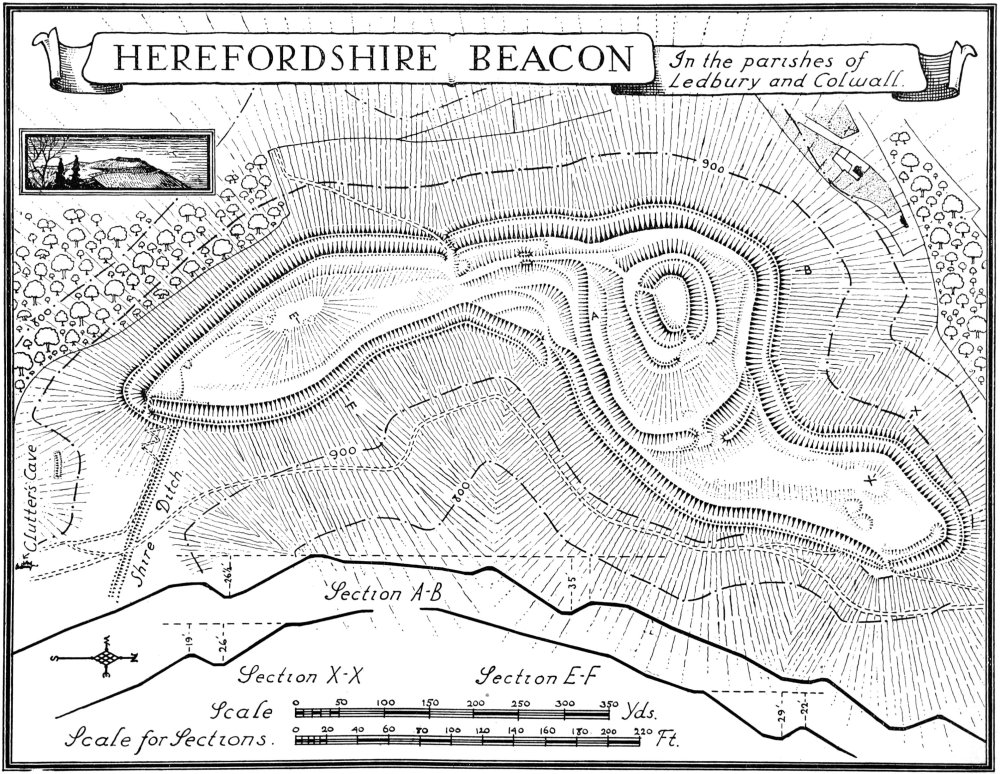
Herefordshire Beacon, in the parishes of Ledbury and Colwall.
The summit of this enclosure has been scarped to form an oval mound with inner rampart, surrounding ditch and terrace beyond. There are two ways of access to this inner enclosure: one from the northern spur, the ditch at this point having an inner rampart which turns slightly outwards on each side of the entrance; opposite to this, the top of the mound itself is reached by way of a causeway over its encircling ditch, the terrace at this point having its outer scarp turned inwards, the S. side being ramparted in addition; the second approach is by way of a partly artificial causeway rising from a point in the camp opposite the W. entrance and continuing up to the terrace, from whence again the mound is reached by a causeway over the ditch. Half-way along the lower causeway are two flanking mounds showing the probable position of a gate or some defensive structure at that point.
This inner mound—called the "Citadel" in many accounts—is stated by Mr. Hadrian Allcroft to have been probably a Norman construction, but there seems to be no definite evidence of this.
Within the camp there are a certain number of sinkings. There is one immediately N.E. of the W. entrance, two S. W. of the N. entrance, and a small one some 50 yards N.W. of the S. entrance. These, from their position, may possibly be the sites of guard-huts. There is also a group of small roughly circular sinkings around the hill-top in the southern portion of the camp, and a single sinking just within the N.E. entrance to the inner enclosure.
The steepness of the scarping and a general similarity in the construction of this camp to that of Midsummer Hill Camp (late La Tène I—La Tène III) would suggest that this work belongs to the same period (see p. 73).
In the neighbourhood of the camp are the following additional features:—Clutter's Cave (Plate 119), 200 yards S.S.E. of the camp in an outcrop of rock, is a small cave with the entrance on the W. side. It seems probable that it is of artificial construction. On the inner wall and facing the entrance is a roughly triangular shaped flat face or panel. The 'Sacrificial Stone,' approximately 90 yards W. of Clutter's Cave, is a boulder of similar stone to that of the cave. About 90 yards S.S.E. of the S. end of the camp on the hillside, running parallel with the contour, is a Pillow Mound, approximately 28 yards by 8 yards, with traces of a ditch at the ends and on the lower side. It has an average height of 3½ ft. above the soil on the lower side.
For the Shire Ditch, see under Eastnor Parish.
Condition—Of camp, fairly good.
a(35). Mounds, on the W. side of Shire Ditch, about 1¾ m. E. of the church, are two in number. They are both about 34 ft. in diameter, the northern 3½ ft. and the southern 2½ ft. high. They are about 5 yards apart and have sunk tops.
Condition—Fairly good.