An Inventory of the Historical Monuments in the County of Northamptonshire, Volume 1, Archaeological Sites in North-East Northamptonshire. Originally published by Her Majesty's Stationery Office, London, 1975.
This free content was digitised by double rekeying. All rights reserved.
'Higham Ferrers', in An Inventory of the Historical Monuments in the County of Northamptonshire, Volume 1, Archaeological Sites in North-East Northamptonshire(London, 1975), British History Online https://www.british-history.ac.uk/rchme/northants/vol1/pp54-56 [accessed 30 April 2025].
'Higham Ferrers', in An Inventory of the Historical Monuments in the County of Northamptonshire, Volume 1, Archaeological Sites in North-East Northamptonshire(London, 1975), British History Online, accessed April 30, 2025, https://www.british-history.ac.uk/rchme/northants/vol1/pp54-56.
"Higham Ferrers". An Inventory of the Historical Monuments in the County of Northamptonshire, Volume 1, Archaeological Sites in North-East Northamptonshire. (London, 1975), British History Online. Web. 30 April 2025. https://www.british-history.ac.uk/rchme/northants/vol1/pp54-56.
26 HIGHAM FERRERS
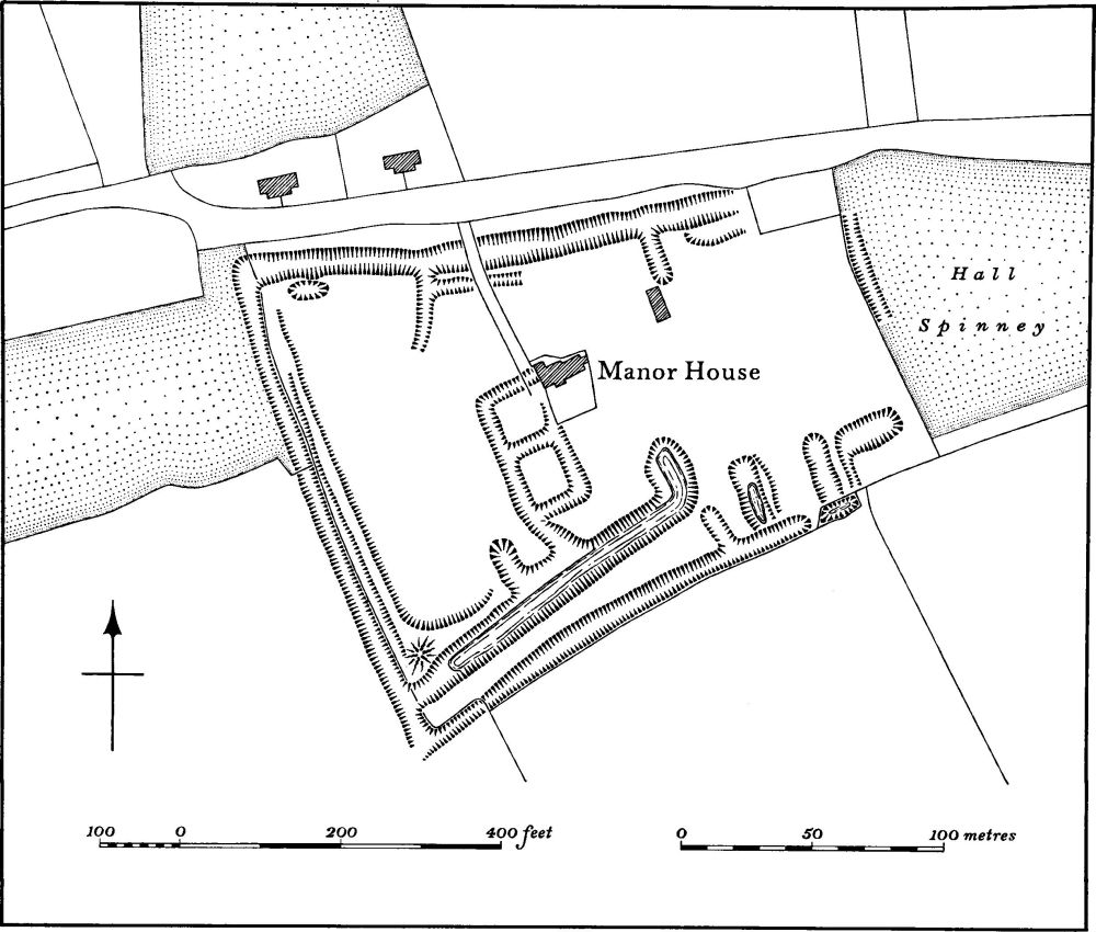
Fig. 66 Hemington (3) Moat and garden remains
(OS 1:10000 a SP 97 SE, b SP 96 NW, c SP 96 NE)
The parish, covering 800 hectares, lies E. of the R. Nene on land rising gradually to the S. between 100 ft. and 260 ft. above OD. The higher southern part is covered by Boulder Clay, but around the town and also along Chelveston Brook, which forms the N. boundary, are extensive areas of limestones and sands.
Evidence for Roman occupation (1–8) is widespread in and N.E. of the town. This may possibly belong to one very large settlement area. The earthworks usually believed to be the site of the medieval castle (9) are in fact fishponds and a rabbit warren.
Prehistoric and Roman
c(1) Iron Age and Roman settlement (SP 96046979), in the N. of the parish, on sand at 180 ft. above OD. Various 'Iron Age features' were found in a gas pipeline trench at this point, associated with 'crude shell-tempered sherds'. One pit contained pottery, charcoal, burnt ironstone and slag. Roman pottery and building-stone were also found. (BNFAS, 2 (1967), 6; Beds. Arch. J., 7 (1972), 14, Higham Ferrers 4)
c(2) Roman settlement (centred SP 955690) lies immediately E. of the R. Nene on rising ground at about 200 ft. above OD. The subsoil is mainly sand and clay. Finds and crop-marks have been noted over an area of some 40 hectares N.W. of the town. These include a small 4th-century building on the site of an earlier one of the 2nd or 3rd century, excavated in 1960 but not published (SP 954689). When built over in 1963, pottery including samian was discovered; other buildings, with no recorded details, were located in 1960 (around SP 953692); a coin, stone footings, areas of burning and two skeletons were found in 1966 in a gas pipeline trench (SP 95426918); a limestone Doric capital, perhaps part of a balustrade, was ploughed up in 1966 (SP 95506938); crop-marks of rather ill-defined rectangular enclosures and linear ditches have been noted centred SP 95506890. In the same area, pits containing bones, 2nd to 4th-century pottery, two coins and a bronze pin were discovered when holes were dug for industrial waste in 1963. (MOPBW, Annual Excavation Report, (1961), 9; JRS, LII (1962), 174; BNFAS, 2 (1967), 11, 12, 33; Beds. Arch. J., 3 (1966), 5; Air photographs in NMR; CUAP, WO 12)
c(3) Roman cemetery (?) (SP 960694), near the junction of the A6 and A605 roads at the N. end of the town. It was discovered in the mid 18th century when human ashes, burnt stone and part of a 'Roman Urn' were found. These may be associated with the settlement (2) above. (Gent's Mag., 27 (1757), 235)
c(4) Roman settlement (?) (SP 96466881), in the N.E. of the town, on sand and limestone at 240 ft. above OD. A few Roman sherds were found in a pit or ditch during roadwidening. In the same general area and to the W., Roman coins have been found at various times; one of the 3rd century was found in 1964 (at SP 960683) and two of the 4th century in 1951 and 1959 (at SP 95916900 and 96176870) (inf. R. Moore; OS Record Cards). There is also an unsatisfactory record of Roman buildings, said to be baths, having been discovered 'in the easterly part of the Castle grounds', and of a possible Roman lamp being found near the church (Whellan, Dir., 917).
c(5) Roman settlement (SP 96906968), on the S. side of a small valley on sand and clay at 170 ft. above OD. A trench for a gas pipeline revealed a series of pits and ditches, some containing Roman pottery including samian. (BNFAS, 2 (1967), 19, listed under Stanwick)
c(6) Roman settlement (SP 974688), E. of the town, on Boulder Clay at 250 ft. above OD. Roman pottery and building-stone have been found associated with an area of dark soil (Beds. Arch. J., 7 (1972), 14, Higham Ferrers 5).
c(7) Roman settlement (SP 965683), S.E. of the town, on limestone at 250 ft. above OD. An area covering about 0.4 hectares had occupation debris, Roman pottery and a small quantity of stone on it (Beds. Arch. J., 7 (1972), 14, Higham Ferrers 6).
c(8) Enclosures (SP 958697), N. of the town, on sand and limestone at 180 ft. above OD. Very faint indications of sub-rectangular enclosures are visible as crop-marks on air photographs. They may be connected either with the Roman settlement to the S. (2) or with the Iron Age site to the E. (1). (BNFAS, 6 (1971), 14).
For alleged Roman Road 570, see p. 116.
Medieval and Later
c(9) Site of Castle, Fishponds and Rabbit Warren (SP 961688; Fig. 67; Plates 8, 9), E. of the main street of Higham Ferrers, and immediately N. of the church, on flat land at 230 ft. above OD.
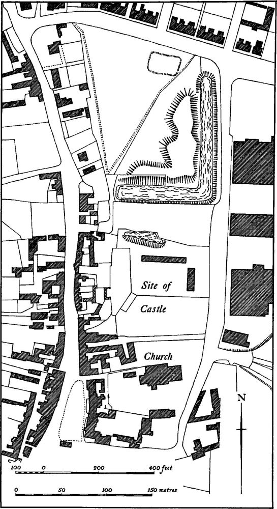
Fig. 67 Higham Ferrers (9) Site of castle, fishponds and rabbit warren
The Castle was probably built soon after 1066 by William Peverel who was granted the manor of Higham Ferrers at the Conquest. Little is known of its history apart from its connection with a series of distinguished owners of the manor. It presumably ceased to function as a military stronghold early and became little more than a manor house. Various documents record buildings associated with the site. There are a number of references to a drawbridge and gates, and occasionally to a chapel. Other references are made to the great hall, a number of named chambers, a kitchen, larder, buttery, pantry, etc., as well as to stables, barns and animal-sheds. The site was neglected by the late 15th century and in 1523 Sir Richard Wingfield was licensed to remove stones from the site to rebuild Kimbolton Castle.
Leland described it as 'now of late cleare fallen and taken down', and in 1610 Norden said that 'there was some time a very fayre and large castle, a mansion house how raysed to grounde whose rubble and old foundations argur the same to have been very great and stronge'. Norden also depicts the castle on his map of Higham Ferrers as an area of broken masonry and uneven ground. (VCH Northants., III (1930), 266–9; M. W. Beresford, History on the Ground, (1957), 153–72; W. J. B. Kerr, Higham Ferrers Castle and Park. (1922))
The greater part of the site has now been built over and no record was made of finds during construction work, except for a note of the discovery of some medieval pottery. In 1967 limestone foundations, a wall and a small rectangular chamber were noted in the paddock immediately N. of the castle site (at SP 96126866), and further walls were traced by probing (BNFAS, 2 (1967), 25). No buildings are shown on the site either on Norden's Map or on the map of the parish of 1796 (Plate 8). The remains are probably those of outbuildings. The only visible earthworks which may be part of the castle are on the S. side of the paddock and comprise a scarp 2 m. high orientated E.-W., with a pond or part of a wet ditch on its N. side. This scarp may be the only remnant of the outer defences.
Rabbit Warren and Fishponds (Plates 8 and 9). Immediately to the N. of the castle site is a large rectangular area, covering just over one hectare and marked as 'Castle' on OS maps, which was part of the outer ward of the castle. It is bounded on the E. and S. sides by a large L-shaped moat or pond up to 30 m. wide and 2.5 m. deep. On the inside is a massive mound of spoil, of highly irregular form, much of which is apparently from the adjacent moat. On the N. side of the area was formerly a rectangular depression or pond, now levelled. In 1796 this latter pond apparently did not exist, but there were two other small square ponds and a rectangular one S. of the W. end of the main moat. Norden's Map of 1610, however, shows a different layout. The ponds S. of the moat did not exist and the latter is shown as two separate rectangular ponds joined by a narrow channel. In addition another rectangular pond was shown in the angle of the moat.
The original purpose of this area is not known but by the 15th century at least, it was a rabbit warren belonging to the manor of Higham Ferrers of which many records survive (R. M. Sarjentson, 'The Court Rolls of Higham Ferrers', Ass. Arch. Soc. Reps., XXXIII (1915–16), 95–146, 326–72; XXXIV (1917), 47–102). The area was still known as the Coney Garth in 1796 (Plate 8). The large mound of spoil was presumably used as burrows as suggested by its uneven surface. The arrangement of the ponds and moats, as well as their relationship to the castle, suggests their use as fishponds (Northants. Past and Present, 5 (1974), 79–84).
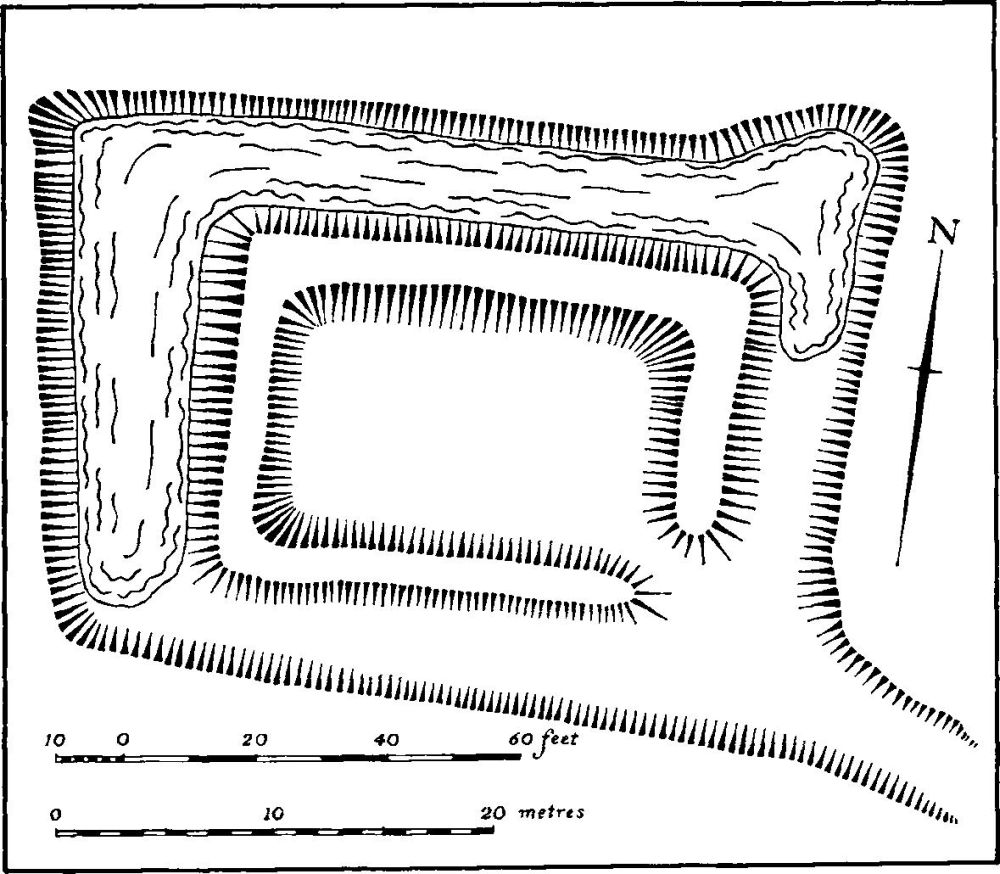
Fig. 68 Higham Ferrers (11) Moat
c(10) Fishponds (SP 957693), now completely destroyed, lay N.W. of the town in the valley of a small brook draining N.W. into the R. Nene. The only indication of their lay-out is on OS maps (especially 25 in., Northamptonshire, XL 1 and 2) which suggest that they comprised two rectangular embanked ponds. They were almost certainly of medieval date.
c(11) Moat (SP 95826870; Fig. 68; Plate 8) lies immediately W. of the town on flat land at 230 ft. above OD. A deep, partly water-filled ditch up to 12 m. wide surrounds a small island about 20 m. square. The interior of the island has been largely dug away in the centre. The name given to it, Saffron Moat, merely refers to the old fields in which it lay, once called Saffron Close. It is only shown as a rectangular pond on a map of Higham Ferrers of 1789 (NRO).
c(12) Medieval farmstead (SP 985671 ?), probably somewhere S.E. of Buscott's Lodge, in the valley of a small brook draining N.W. on Boulder Clay at 260 ft. above OD.
There are records of a place called Britwinescote or Brywynscott hereabouts from the late 13th century, interpreted as the 'cote or cottage of Brihtwine' (PN Northants., 191). This settlement was presumably associated with the rectangular projection of Higham Ferrers parish, which extends to the S.E. The area which is shown as old enclosures on a map of Higham Ferrers of 1789 (NRO), lay outside the permanent arable of the common fields.
No definite remains have been discovered in the area. Quantities of medieval pottery, mainly of the 13th and 14th centuries, have been found widely scattered, but are not in sufficient concentrations to indicate former habitation.
(13) Cultivation remains. The common fields of the parish were enclosed by Act of Parliament of 1838 (VCH Northants., III (1930), 263). On a map of the parish dated 1789 (NRO) all these fields and individual strips are depicted. There were then four fields but one, Gunsex Field, W. of the town, had already been largely enclosed. Ridge-and-furrow of these fields exists on the ground, or can be traced on air photographs, over large areas and agrees exactly with the lay-out of strips and furlongs shown on the map of 1789. It takes the form of end-on and interlocked furlongs. In a number of places (e.g. at SP 971693 and 972686) air photographs indicate earlier headlands underlying existing ridge-and-furrow, which resulted from the reploughing of short end-on furlongs into one furlong. Ridgeand-furrow can also be seen in areas which were already enclosed in 1737 (map in NRO), S.E. of Buscott's Lodge (SP 984672) and N.W. of the town (SP 956691). In the N.E. of the parish, in what was a large area of open waste called Beast Pasture in 1737, there are also traces of ridge-and-furrow (SP 958698). (RAF VAP CPE/UK 1925, 4255–60; 1994, 2397–401, 4222–5, 4400–5; 540/474, 3020–5)