An Inventory of the Historical Monuments in the County of Northamptonshire, Volume 1, Archaeological Sites in North-East Northamptonshire. Originally published by Her Majesty's Stationery Office, London, 1975.
This free content was digitised by double rekeying. All rights reserved.
'Luddington', in An Inventory of the Historical Monuments in the County of Northamptonshire, Volume 1, Archaeological Sites in North-East Northamptonshire(London, 1975), British History Online https://www.british-history.ac.uk/rchme/northants/vol1/pp63-65 [accessed 1 May 2025].
'Luddington', in An Inventory of the Historical Monuments in the County of Northamptonshire, Volume 1, Archaeological Sites in North-East Northamptonshire(London, 1975), British History Online, accessed May 1, 2025, https://www.british-history.ac.uk/rchme/northants/vol1/pp63-65.
"Luddington". An Inventory of the Historical Monuments in the County of Northamptonshire, Volume 1, Archaeological Sites in North-East Northamptonshire. (London, 1975), British History Online. Web. 1 May 2025. https://www.british-history.ac.uk/rchme/northants/vol1/pp63-65.
33 LUDDINGTON
(OS 1:10000 a TL 08 SE, b TL 18 SW, c TL 18 NW)
The parish occupies a long narrow piece of land against the former Huntingdonshire boundary and covers 350 hectares of undulating countryside, between 130 ft. and 230 ft. above OD. It is entirely on Boulder Clay except in the centre where the down-cutting of the Alconbury Brook, which bisects the parish, has exposed Oxford Clay.
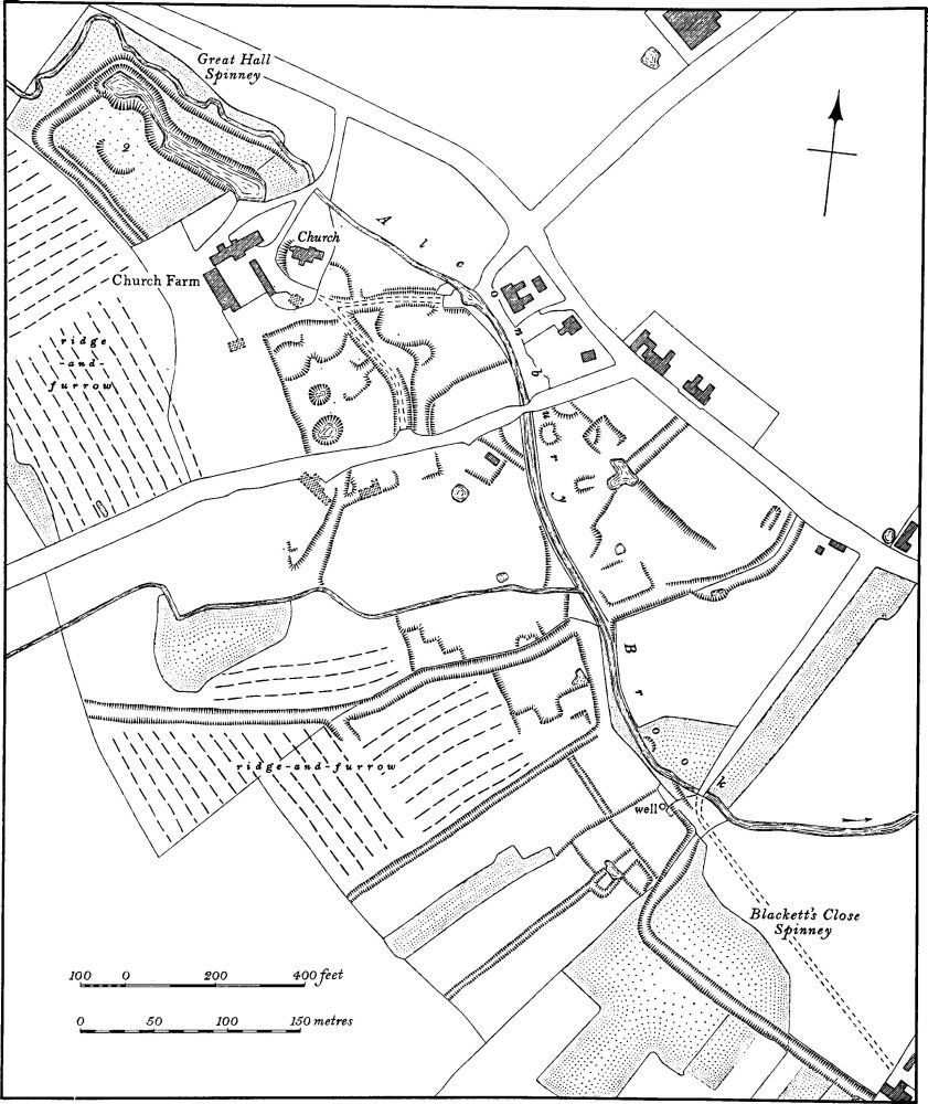
Fig. 73 Luddington (3) Settlement remains and (2) manor house site
The village is notable for its almost complete change of both location and layout which took place during the 19th century and later (2).
Prehistoric and Roman
a(1) Settlement (TL 097835), in the extreme N.W. of the parish, on Boulder Clay, at 180 ft. above OD. Air photographs show a complex pattern of rectangular enclosures or paddocks and at least one hut circle (CUAP, BIF 3–6).
Medieval and Later
b(2) Manor house site (TL 102837; Fig. 73; Plate 18) lies within Great Hall Spinney, immediately N.W. of Church Farm. A large rectangular area is bounded on the S.W. and N.W. by a broad ditch up to 6 m. across and gradually increasing in depth from 0.5 m. in the S. corner of the wood to 2 m. near the N. corner. Along the N.W. is an outer bank up to 2 m. high. The N.E. side is bounded by a long irregular depression, formerly a pond and still often filled with water. No trace of a S.E. boundary exists. The interior is totally overgrown and many features are obscured, but at least one well-marked platform cut into the valley side is visible. The name of the wood and its position suggest that the site is that of a medieval manor house. It had been already abandoned by 1640 (NRO, map of Luddington).
b(3) Settlement remains (centred TL 105835; Fig. 73; Plate 18), formerly part of Luddington, lie in and around the present village. The extensive earthworks are the result of the complete alteration of the village during the 19th and 20th centuries. Up to 1850 and probably later, the village, as its old name of Luddington-in-the-Brook indicates, lay within the valley of the winding Alconbury Brook. In the early 18th century the county historian described its situation as 'low and dirty', because of the constant flooding of the stream (J. Bridges, Hist. of Northants., II (1791), 402–4). A series of maps of 1640, 1715 and 1808 (all in NRO) shows earlier plans of the village.
The Parliamentary Enclosure of the common fields in 1808 provided improved communications in the parish by laying out the present Hemington-Great Gidding road, which replaced the old main street. Up to this time the street lay almost in the bed of the brook. Enclosure had little immediate effect on the village plan and in 1834 (1st ed. 1 in. OS map) the distribution of dwellings appears to be identical with that of 1808. Only after 1850 were houses erected on the new road. Between 1834 and 1886 (1st ed. 25 in. OS map) a number of buildings, including the rectory, two farms and a number of cottages, disappeared. Since then two of the houses have been pulled down, one recently.
The remains of the earlier arrangement of streets and lanes are still almost completely preserved as earthworks, as are the sites of most buildings removed since 1834. In addition a number of other building-sites and closes, already abandoned by 1640, is traceable, indicating a long history of movement or shrinkage.
(4) Cultivation remains. The common fields of the parish were enclosed by an Act of Parliament of 1807 (NRO, Enclosure Map, 1808). Immediately before that date there were four open fields. Ridge-and-furrow of these fields exists in two places: around Rectory Farm (TL 113849), and W. of the church (TL 098836), respectively in the former Black and Long brook Fields. A map of 1716 (in NRO) shows the detailed layout of the strip fields in the parish, and the remaining ridgeand-furrow agrees with it. A low ridge, 700 m. long and 25 m. wide, N.E. of the village (TL 105843) is shown on the 1716 map as a headland between two end-on furlongs (see also map of 1640 in NRO, for part of the parish; RAF VAP 541/143, 3198–3201).