An Inventory of the Historical Monuments in the County of Northamptonshire, Volume 2, Archaeological Sites in Central Northamptonshire. Originally published by Her Majesty's Stationery Office, London, 1979.
This free content was digitised by double rekeying. All rights reserved.
'Rockingham', in An Inventory of the Historical Monuments in the County of Northamptonshire, Volume 2, Archaeological Sites in Central Northamptonshire(London, 1979), British History Online https://www.british-history.ac.uk/rchme/northants/vol2/pp126-130 [accessed 30 April 2025].
'Rockingham', in An Inventory of the Historical Monuments in the County of Northamptonshire, Volume 2, Archaeological Sites in Central Northamptonshire(London, 1979), British History Online, accessed April 30, 2025, https://www.british-history.ac.uk/rchme/northants/vol2/pp126-130.
"Rockingham". An Inventory of the Historical Monuments in the County of Northamptonshire, Volume 2, Archaeological Sites in Central Northamptonshire. (London, 1979), British History Online. Web. 30 April 2025. https://www.british-history.ac.uk/rchme/northants/vol2/pp126-130.
In this section
49 ROCKINGHAM
(OS 1:10000, SP 89 SE)
The parish is small, covering less than 380 hectares. It lies N.W. of Corby and S. of the R. Welland which forms its N. boundary. From the higher Boulder Clay area in the S., between 122 m. and 130 m. above OD, the land drops steeply across Great Oolite Limestone and Lias Clays and Silts to the river gravels and alluvium of the valley of the R. Welland, here flowing at 50 m. above OD. The parish is notable for the large number of medieval and later earthworks which include the motte and bailey of Rockingham Castle (4), extensive settlement remains, once part of the village (7), a large deer park (12), mill sites (8), (9) and (10), and a 17th-century rabbit warren. These have been published fully elsewhere (Northants. Archaeol., 9 (1974), 68–79) and are only described briefly here. The undated closes (14) are of interest in that they may be rare examples of prehistoric or Roman fields.
Prehistoric and Roman
(1) Settlement (?) (SP 879907 and 879912), in the S.E. of parish in an area of ironstone quarries. Pits and ditches, one containing bones, as well as a possible stone scatter, have been noted in the quarry face (BNFAS, 4 (1970), 33).
(2) Roman Iron-Working Site (unlocated), found before 1878, probably during ironstone-quarrying. Iron slag, associated with Roman pottery and coins, is recorded (Arch. J., 35 (1878), 269, 271).
(3) Roman Well and Building (?) (SP 86669128), just within the S.W. side of the S. bailey of Rockingham Castle, on a flat spur at 122 m. above OD. In 1935–6 a deep well containing pottery and tiles, described as Roman, was discovered. A Roman key was found near by (Guide to Rockingham Castle, (1960), 12–13; OS Record Cards). However material in the castle, said to be from the well, is in fact medieval.
Medieval and Later
(4) Motte (SP 86729122; Fig. 113), at the S. end of the standing remains of Rockingham Castle, near the end of a broad, flat-topped spur which projects N.W. from the main limestone escarpment, overlooking the Welland valley at 112 m. above OD.
The motte and its associated baileys were constructed by William I, probably for strategic control of the main river-crossing of the Welland. It seems to have consisted of a central motte with a bailey on each side. The N. bailey was the main one and it is this part of the castle which still survives as a standing structure. A description of these buildings falls outside the scope of this inventory. The motte and the S. bailey remain as earthworks.
The motte has been mutilated and partly destroyed, largely as a result of post-medieval alterations. It survives as a large, curved, terraced bank some 3 m. high on the N. and E. but only as a slight rise on the S. and W. In earlier times it appears to have had a stone keep on its summit. It was refortified in 1644 when a Parliamentary garrison held it. The S. bailey lies S.W. of the motte and has also been badly damaged by later activities. On the E. and W. it is bounded by the steep natural scarps of the spur and on the S. across the neck of the spur by a bank and ditch, which have been reduced to very slight relief. The ditch is some 12 m. wide and 1 m. deep and the bank is less than 1 m. high. Slight traces of ridge-and-furrow survive within this bailey (Northants. Archaeol., 9 (1974), 68–9, for all refs.).
(5) 'Moats' (SP 870909 and 871910), lie 450 m. S.E. of the castle, on the edge of the present park, on Boulder Clay at 130 m., above OD. On a map of 1615 these features, which are now separated by the modern drive to the castle, are shown joined together. The earthwork known as the Bottom Moat lies N.E. of the drive and consists of a sub-rectangular area completely surrounded by a water-filled ditch some 2m. deep. To the S.W. the so-called Top Moat is no more than a long ditch which widens to form a pond near its N.E. end. No date or function can be assigned to these features (Northants. Archaeol., 9 (1974), 71).
(6) Pillow Mounds (centred SP 870911; Fig. 113), in the S.E. of the park, 300 m. S.E. of the castle on level ground on the top of a spur at 122 m. above OD. There are three rectangular mounds, 0.5 m. high with flat or gently rounded tops, ranging in size from 30 m. by 5 m. to 24 m. by 9 m. There is a similar rectangular mound further to the N. on the edge of the spur, with another below it within the embanked close of a former house of the village of Rockingham (7). Also on top of the spur are two mounds 100 m. long and 7 m. wide, parallel to each other and orientated N.W.—S.E. These overlie earlier ridge-and-furrow. These mounds probably belong to the class of earthworks known as pillow mounds, sometimes associated with rabbit warrens of medieval and later date. There is some evidence that this area was indeed a warren in the 17th century and it has been suggested that it was in use between 1618 and 1644 (Northants. Archaeol., 9 (1974), 71).
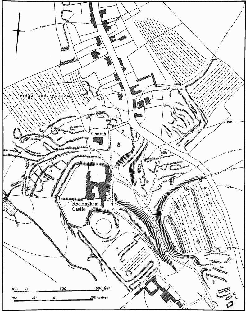
Fig. 113 Rockingham (4) Motte, (6) Pillow mounds, (7) Settlement remains, (14) Enclosures
In the same area there are 11 small circular mounds, up to 9 m. in diam. and 0.5 m. high, which all overlie ridge-and-furrow. These are all probably 18th or 19th-century tree-mounds, connected with the landscaping of the park.
(7) Settlement Remains (centred SP 867915; Fig. 113). N. and N.E. of the castle around the now isolated church on land sloping steeply towards the modern village. A map of 1615 shows houses still standing in the vicinity of the church and in the combe to the S., near the gatehouse of the castle. The main road to Corby then passed through the S. part of the settlement and up a narrow defile just S.E. of the castle. This road was blocked in 1618 and replaced by the present road to the E. At the same time or a little later the houses were removed and the area became grassland. Remains of these houses and their associated closes are visible near the church, but in a very fragmentary state. Building platforms W. of the church indicate that the village once extended in that direction, but they had been deserted by 1615. Pottery found in the area ranges in date from the 12th to the 17th century.
Further to the W. and N. of the castle are two deeply cut hollow-ways which formerly led into the village near the church. These appear to have been abandoned by the early 17th century. To the S.E. of the present village (SP 867915) another hollow-way with a right-angle bend climbs the steep escarpment. In 1615 this was part of a back lane to the village which ran on up the hillside to join the Corby road. To the W. of it the hillside is cut by a series of older tracks (Northants. Archaeol., 9 (1974), 75).
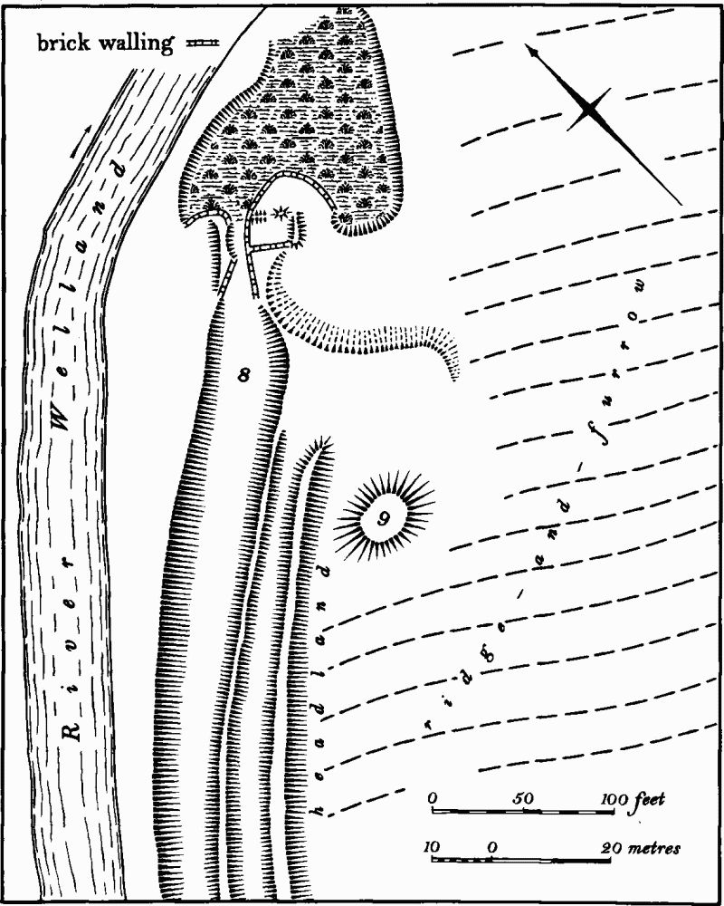
Fig. 114 Rockingham (8) Site of watermill, (9) Windmill mound
(8) Site of Watermill (SP 861919; Fig. 114), in the N. of the parish, beside the R. Welland, on alluvium at 50 m. above OD. A watermill, which may have been on this site, is mentioned in Domesday Book and in a number of later documents. Various maps, from an estate map of 1615 to the OS 6 in. of 1887, show a watermill on the present site, but by 1901 it had been abandoned. The remains consist of a broad leet, 13 m. wide and 1.5 m. deep, running parallel with the river and leading to the site of the mill, now a narrow channel lined with stone and brick walls. On either side are the grass-covered foundations of the mill itself. Below is an irregular marshy area which was formerly a pond (Northants. Archaeol., 9 (1974), 76–7; RAF VAP 541/612, 3055–6).
(9) Windmill Mound (SP 861918; Fig. 114), immediately S. of (8) in a similar position. A windmill did not exist on this site in 1615 (Map in Rockingham Castle Archives) when the watermill (8) stood alone, but by 1650 a windmill had been built which was still standing in 1887. By 1901 it had been demolished. The site now consists of a low mound, 20 m. in diam. and 1 m. high. It was apparently erected on former arable land, for a headland still survives between it and the adjacent watermill (Northants. Archaeol., 9 (1974), 76–7).
(10) Site of Watermill (SP 87219236), in the extreme N.E. corner of the parish, by the R. Welland, on alluvium, at a point where a small stream enters the river from the S. There are references in 16th and 17th-century documents to a second watermill in Rockingham in addition to the main and older one (8), and a building certainly stood on the site in 1615 (Map in Rockingham Castle Archives). It was no longer there in 1806 (NRO, Map of Rockingham). Part of an abandoned leet still remains and the site of the building is marked by a low terrace and areas of stone and brick (Northants. Archaeol., 9 (1974), 77).
(11) Hollow-Way (SP 86559220), now destroyed, lay in the N. of the parish immediately E. of the Caldecott Road where it crossed the present course of the R. Welland. It can still be traced for some 600 m. to the N. in Caldecott parish, in Leicestershire, where it swings W. in a broad arc before regaining the modern road. It is presumably the original line of the medieval road abandoned when the present straight road was cut probably in the 18th century, and certainly before 1806 (NRO, Map of Rockingham).
(12) Deer Park (centred SP 861905; Fig. 115), occupies a large area of land S.W. of Rockingham Castle and extending into Cottingham parish. It is situated in a natural amphitheatre on the very broken edge of the Jurassic escarpment between 68 m. and 130 m. above OD, and has several springs within it.
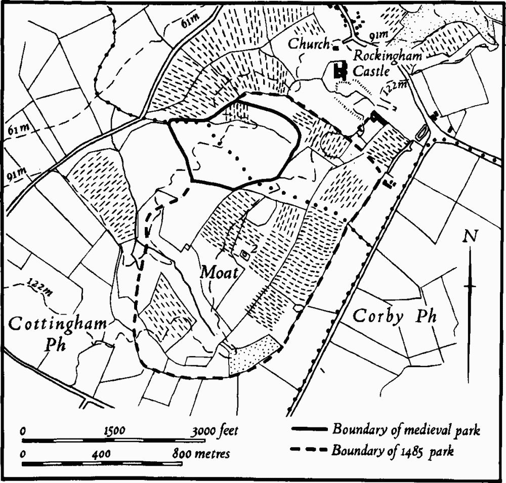
Fig. 115 Rockingham (12) Deer park and Cottingham (2) Moat
A park certainly existed in 1256, but it was probably small, covering little more than 13 hectares on either side of the boundary with Cottingham. Its original pale survives on the S.W. side as a bank 2 m. high and 4 m. wide with a shallow internal ditch, 2 m. across. On the S. side the steep N.—facing slope probably obviated the need for an earthen bank. On the flatter ground to the S.E. the bank reappears, 0.5 m high and 5 m. wide and continues N. and N.W. up a steep slope as a terrace 2 m. wide. The N.W. side has no surviving boundary, but followed the crest of a ridge at this point.
This early park was enlarged to the E. and S. in 1485 to cover some 108 hectares, mainly in Cottingham. The boundaries of the new park are marked on a map of 1615 (in Rockingham Castle Archives) but are difficult to trace on the ground, perhaps because they were never very substantial. Some slight ditches and low banks are all that have been noted. The park was further enlarged to the W. in 1638 (Northants. Archaeol., 9 (1974), 72–4).
(13) Cultivation Remains. The enclosure of the common fields of the parish took place over a long period of time. The earliest known arrangement of these fields is in a terrier of 1544–5 which described four fields, Over, East, West and Mill. The 1615 map of the parish shows only three fields, the West and Mill Fields having been amalgamated to become Nether Field. During the 17th century, but before 1638, the whole of Over Field was enclosed and there were some small enclosures made in the East Field. The final enclosure of the rest of the parish took place between 1806 and 1815 without any Act of Parliament (Northants, Archaeol., 9 (1974), 75–6).
Ridge-and-furrow of these fields exists on the ground or can be traced on air photographs over most of their area, except in the S.E., in the former Over Field, where ironstone-working has destroyed it. The ridge-and-furrow is arranged mainly in end-on furlongs across the steep slopes. Ridge-and-furrow also exists in areas which were outside the common fields in 1615. It is particularly well-marked within the area of the late medieval deer park (12) which was enlarged from an early small park in 1485. The presence of ridge-and-furrow here suggests that the park was made partly by enclosing a large area of former arable land. It can also be seen in paddocks and closes behind houses in the present village and in the parkland around the castle. A small block even exists within the S.W. bailey of the castle (Fig. 113; RAF VAP F22 58/RAF/1210, 0012–5; 541/612, 3052–6, 4051–7).
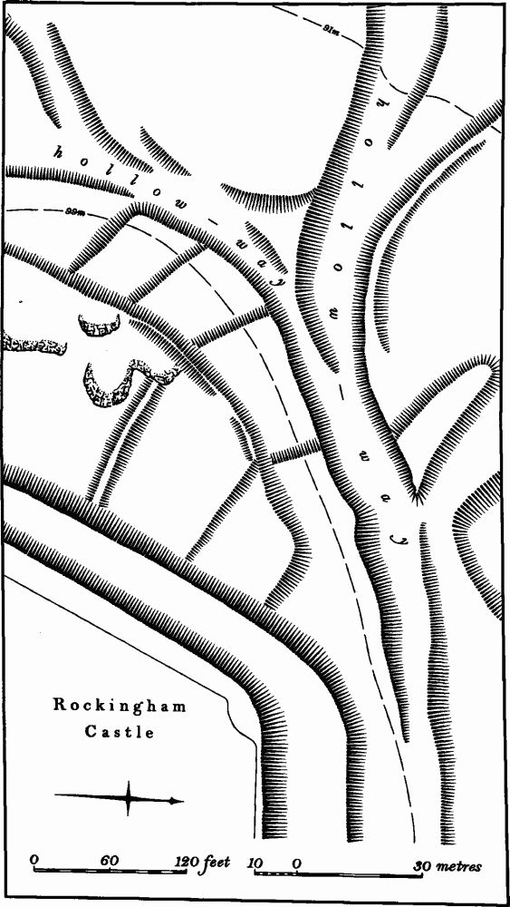
Fig. 116 Rockingham (14) Enclosures
Undated
(14) Enclosures or Fields (SP 866914; Figs. 113 and 116), immediately N. of Rockingham Castle on a steep hillside at 100 m. above OD. They consist of a group of small rectangular closes bounded by low scarps and banks, nowhere more than 0.25 m. high. The N., lower ends are cut by the medieval hollow-way into the village and the S. ends appear to be overlain by the massive outer terrace of the N. bailey of the castle. The interiors of some contain small quarry pits. They are of unknown date and purpose, but are probably medieval. However from their size and form it is conceivable that they are earlier fields of prehistoric or Roman date, of the type usually known as 'Celtic' fields.