An Inventory of the Historical Monuments in the County of Northamptonshire, Volume 2, Archaeological Sites in Central Northamptonshire. Originally published by Her Majesty's Stationery Office, London, 1979.
This free content was digitised by double rekeying. All rights reserved.
'Stoke Albany', in An Inventory of the Historical Monuments in the County of Northamptonshire, Volume 2, Archaeological Sites in Central Northamptonshire(London, 1979), British History Online https://www.british-history.ac.uk/rchme/northants/vol2/pp136-138 [accessed 30 April 2025].
'Stoke Albany', in An Inventory of the Historical Monuments in the County of Northamptonshire, Volume 2, Archaeological Sites in Central Northamptonshire(London, 1979), British History Online, accessed April 30, 2025, https://www.british-history.ac.uk/rchme/northants/vol2/pp136-138.
"Stoke Albany". An Inventory of the Historical Monuments in the County of Northamptonshire, Volume 2, Archaeological Sites in Central Northamptonshire. (London, 1979), British History Online. Web. 30 April 2025. https://www.british-history.ac.uk/rchme/northants/vol2/pp136-138.
In this section
53 STOKE ALBANY
(OS 1:10000 a SP 78 NE, b SP 88 NW)
The long, narrow parish covers 690 hectares, immediately N. of Desborough. The S. part is on an almost level, Boulder Clay plateau between 122 m. and 137 m. above OD. To the N. the down-cutting of a number of small N. and N.E.-flowing streams has exposed large areas of limestones, clays and silts between 73 m. and 122 m. above OD. In the extreme N. the land rises again to a Boulder Clay upland with a maximum height of 110 m. above OD. No prehistoric or Roman finds have been made in the parish but three of the remaining medieval and later earthwork sites (1–3) are very well preserved.
Medieval and Later
b(1) Site of Watermill (SP 810881; Fig. 121; Plate 9), in the bottom of a steep-sided valley, against the Wilbarston parish boundary, on clay at 85 m. above OD. The main feature is a large earthen dam, some 3 m. high, which spans the valley W. of the existing stream. This dam has a gap near its E. end, and limestone rubble is exposed in the sides, presumably where the mill-wheel stood. Beyond, to the N., is a broad channel, undoubtedly the mill-race, which runs for some 60 m. before joining the stream. At the W. end of the dam is another channel which probably carried surplus water around the mill. Above the dam is a large trapezoidal pond, the interior of which is largely occupied by a triangular island with a circular mound 1.5 m. high at its apex. Such islands have been noted elsewhere (see Braybrooke (1) and Walgrave (8), and Sectional Preface, p.lx). Traces of an inlet channel exist beyond the S. corner of this pond, and there is a gap in the S.E. corner which may also have provided an entrance for water. To the S. again the modern road (A 427) crosses the valley on an embankment which has obscured the original course of the stream. The field to the S. of this, in Wilbarston parish, was known as The Dam in 1815 (Map of Wilbarston in NRO). The site has been described as a set of fishponds, but its use as a mill is more likely (Northants. P. and P., 4 (1971), 309–10, listed as Wilbarston; CUAP, AZS 70; RAF VAP CPE/UK/2109, 4274–6; air photographs in NMR.
b(2) 'Moat' and Fishponds (SP 807883– 808878; Fig. 122; Plate 10), in the bottom of a steepsided valley, immediately E. of the village, on clay between 76 m. and 91 m. above OD.
Immediately S. of the main Stoke Albany—Wilbarston Road (A 427) there is a large sub-rectangular pond, with an earthen dam up to 3.5 m. high on its N. side. The dam is now broken in the centre to allow the modern stream to pass through. An overflow channel at the E. end of the dam allowed the ponded-up water to flow into the next section, where water ran into two channels. To the E. it passed along a broad water-course and into the ditch surrounding a small moated site. The island within the moat is rectangular, 2.5 m. above the bottom of the ditch, and has no interior features. Whether this is a true moat or an island constructed for some other purpose is unknown. To the W. the water flowed past the island in a channel which now contains the modern stream. The water from the moat passed either back into this channel through a gap in the N.W. corner or into a rectangular embanked pond to the N. Thereafter all the water ran into a large, irregular, shallow pond, dammed at its N. end by a low bank 1.5 m. high. There is a small, rectangular pond at the W. end of the main pond. The dam has been broken at the centre. The present stream flows obliquely across the large pond and passes, in an artificial cut, under the modern road towards the earthworks further N. (3).
All the remains are undoubtedly part of the manorial complex of Stoke Albany and are associated with the existing medieval manor house to the W. They are certainly those referred to in the early 13th century when William d'Aubigny, who then held the manor of Stoke Albany, was granted ten small pike and ten small bream from the fishpond at Rothwell (Rothwell (7)) to stock his fishpond at Stoke (Cal. Close 1231–34, 157, 209; Northants. P. and P., 4 (1971), 302, 308–9). The fields in which the earthworks lie were known as Hall Close and Home Close in 1802 and 1841 (NRO, Map of Part of Stoke Albany and Tithe Map).
At the extreme N. of the site, N. of Lower Road and E. of the Rectory are more earthworks, alongside the bed of the original stream. They consist of a rectangular area bounded on the N. and W. by a low bank, with an external ditch on the W. Low scarps in the interior suggest that it is the site of a building.
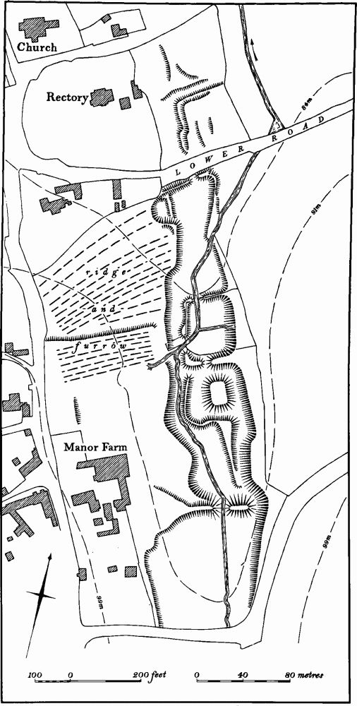
Fig. 122 Stoke Albany (2) Fishponds
W. of the moat and N. of the manor house scarps indicate two closes or paddocks, perhaps belonging to former houses in the village. The more northerly of these is over-ploughed with ridge-and-furrow (CUAP, AZS 71; RAF VAP CPE/UK/2109, 4272–6).
b(3) Site of Watermill (SP 807884), N.E. of Stoke Albany, on clay at 76 m. above OD. The site consists of a large earthen dam 2 m. high, lying across a shallow valley. The ends of the dam return southwards as low scarps to contain the mill-pond. This pond was fed by the existing stream which was diverted to the E. from its original course after the abandonment of the fishponds above it (2). The site of the mill itself is an area of disturbed ground below the dam to the N. The mill existed until at least the early 19th century (NRO, Map of Stoke Albany, 1802; 1st ed. 1 in. OS map (1834)), but had gone by 1841 (NRO, Tithe Map) when the field was called Mill Close (CUAP, AZS 71; RAF VAP CPE/UK/1209, 4137–8).
b(4) Deer Park (centred SP 810870; Fig. 123), lies S. of Stoke Albany village, almost entirely on Boulder Clay at around 122 m. above OD.
In 1200 William de Albini obtained licence to enclose 'his park in Estokes, named the Lund, with all liberties belonging to it . . .' (J. Bridges, Hist. of Northants., II (1791), 339; Northants. P. and P., 5 (1975), 231). The later history of the park is unknown but it is still marked on Saxton's map of Northamptonshire (1576).
The park covers a little more than 1 sq. km., and was once completely surrounded by a bank or scarp. This boundary or pale is best preserved along the W. and S. sides of Bowd Lane Wood (SP 80908642–80578643– 80568686), formerly called Lound Wood (1st ed. 1 in. OS map (1834)). Here, apart from modern breaks, it is a continuous bank, 8 m. across and up to 1.5 m. high, with a broad, inner ditch, 5 m. wide. N. of the wood is a modern pasture field with, along its W. edge (SP 8056890), a ploughed-down bank, 7 m. wide and only 0.25 m. high, with slight traces of an inner ditch. Beyond this the boundary runs in a broad curve around the grounds of Stoke House. To the W. of the house modern landscaping has removed most of the bank although slight traces of it are visible in places. Further N. the present road runs along the top of the artificial scarped edge of a shallow valley. This scarp, up to 2 m. high, is assumed to be the park boundary. At the N.W. corner of Stoke House Grounds (SP 80688746) the boundary, visible as a steep N.-facing scarp, turns E. and runs for some 400 m. to a point N. of Stoke Park Farm. N. of the farm the modern hedge is on a small field bank, but in the field beyond there is a broad depression or ditch, largely flattened by later ploughing, which is perhaps the line of the park boundary. N.E. of Stoke Park Farm the hedge is on a large bank, some 7 m. wide and 1.5 m. high, which extends E. for 200 m. and then (at SP 81508731) turns S.S.E. and runs to the N.E. corner of Walter Wood (SP 81638701), along the Wilbarston parish boundary. The bank can be traced along the E. side of the wood for 200 m. A map of Wilbarston of 1815 (NRO) gives the name of the field E. of Walter Wood as 'Above The Park'. Beyond this point no trace of the park boundary exists as the construction of the Second World War airfield destroyed all the remains, but its line can be established from various pre-1940 maps. It continued S. along the Wilbarston parish boundary for 250 m. and then turned W. (at SP 81398544). At this point there was a field known as Park Corner in 1802 (NRO, Map of Part of Stoke Albany) which lay just inside the parish but outside the park. The boundary then ran on westwards until it reached the S.E. corner of Bowd Lane Wood (RAF VAP CPE/UK/2109, 4276–7).
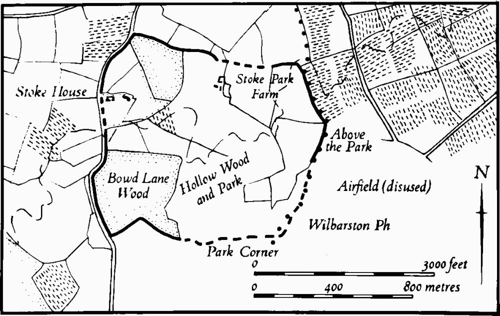
Fig. 123 Stoke Albany (4) Deer park
(5) Cultivation Remains. The common fields of the parish were enclosed by Act of Parliament of 1764.
Ridge-and-furrow of these fields exists on the ground or can be traced from air photographs over most of the parish, with the exception of the area covered by the medieval deer park (4). It is arranged mainly in end-on furlongs and where they are interlocked (e.g. in the extreme N. of the parish at SP 795894) it appears to be the result of ensuring that the ridges run across the contours on the steeply sloping, broken ground. A few well-marked long ridges, formerly headlands, still remain on the ground. One of these, W. of the village (at SP 796878–800883) is 550 m. long (RAF VAP CPE/UK/ 2109, 3276–81, 4136–40, 4274–9; 541/612, 4024–8).