An Inventory of the Historical Monuments in the County of Northamptonshire, Volume 3, Archaeological Sites in North-West Northamptonshire. Originally published by Her Majesty's Stationery Office, London, 1981.
This free content was digitised by double rekeying. All rights reserved.
'Preston Capes', in An Inventory of the Historical Monuments in the County of Northamptonshire, Volume 3, Archaeological Sites in North-West Northamptonshire(London, 1981), British History Online https://www.british-history.ac.uk/rchme/northants/vol3/pp163-168 [accessed 30 April 2025].
'Preston Capes', in An Inventory of the Historical Monuments in the County of Northamptonshire, Volume 3, Archaeological Sites in North-West Northamptonshire(London, 1981), British History Online, accessed April 30, 2025, https://www.british-history.ac.uk/rchme/northants/vol3/pp163-168.
"Preston Capes". An Inventory of the Historical Monuments in the County of Northamptonshire, Volume 3, Archaeological Sites in North-West Northamptonshire. (London, 1981), British History Online. Web. 30 April 2025. https://www.british-history.ac.uk/rchme/northants/vol3/pp163-168.
In this section
52 PRESTON CAPES
(OS 1: 10000a SP 55 NE, b SP 55 SE, c SP 64 SW)
The parish, covering some 1100 hectares, lies on a watershed from which streams flow E. to the R. Nene, S.E. to the R. Tove, and W. to the R. Cherwell. The highest part is in the N., and the village of Preston Capes and the hamlet of Little Preston (2) both lie on the summit of an uneven E.–W. ridge of Northampton Sand between 168 m. and 188 m. above OD. The land falls precipitously to the N., and to the S. more gently, to an undulating clayland between 122 m. and 135 m. above OD in which the main streams lie.
The parish contains two medieval settlements each with its own land unit (Fig. 124). Preston Capes is the main village and has a fine Norman motte (1), now damaged on its E. side. Little or Wood Preston (2), though always small, shows evidence of considerable shrinkage; the earthworks of the Manor House (3) suggest that it too may have been fortified at an early date. Much of the land of Little Preston was a deer park (4) in the later medieval period.
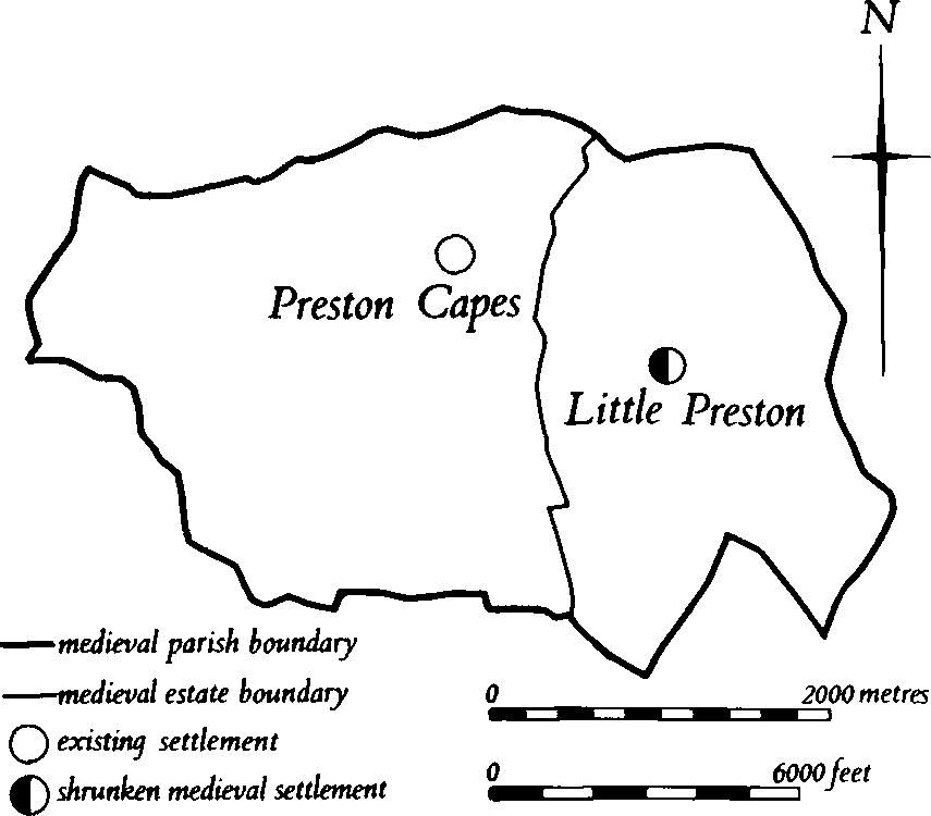
Fig. 124 Preston Capes Medieval settlements and estates
Medieval and Later
b(1) Motte (SP 576549; Fig. 125; Plate 3), known as Preston Capes Castle, stands on the summit of a N.-projecting spur on the N.E. side of the village, on Upper Lias Clay, at 165 m. above OD. On all sides but the S. the land slopes steeply from the edge of the motte ditch and there are extensive views, especially to the N.
The exact date of the construction of the castle is unknown but it was probably built soon after the Norman Conquest. In 1086 Preston was held by Nigel of the Count of Mortain (VCH Northants., I (1902), 328). Around 1090 it certainly existed, for a Cluniac Priory was founded at that time by Hugh de Leicester 'ajoining his castle' at Preston Capes. Nothing more is known of the castle, but the site remained the centre of the manor, even though the priory was moved to Daventry in 1107–8. The existing Manor Farm, which stands to the S.E. of the motte, is the modern successor to the medieval manor house (VCH Northants., II (1906), 109–110). On a map of 1742 (NRO) the area is called Castle Hill.
The site consists of a small conical motte some 4 m. high with a flat top 27 m. across. The S. side has been cut and mutilated by farm buildings and if there ever was a ditch at this point no trace of it survives. Elsewhere at the base of the motte is a shallow ditch no more than 1 m. deep which still holds water at one place. Along the outer edge of the ditch is a small bank only 0.25 m. high which, externally, is little more than a steepening of the natural hillside.
No trace of a bailey survives, although previous workers have suggested that one probably occupied the flatter ground to the S.E. (E. S. Armitage, Early Norman Castles (1912), 190); another source suggests that a slight depression to the S. might be the remains of its ditch (OS Record Cards). However, although it is likely that there was a bailey in this area, the present Manor Farm and its buildings have destroyed all trace. Various low scarps and shallow depressions S. of the farm appear to be the remains of old farm buildings.
Below the castle, at the bottom of the spur and curving around its base, is a large bank with a broad ditch on its S., uphill, side. The bank is between 1 m. and 2.5 m. high, with the greatest elevation at the ends. At its S.E. end the ditch broadens out into a wide depression, with what appear to be old quarry pits above it. The ridge-and-furrow to the N. terminates well short of the bank which is therefore contemporary with or older than the medieval ploughing. No date or function can be assigned to this feature.
b(2) Settlement remains (SP 588542; Figs 124 and 126; Plate 3), formerly part of the hamlet of Little Preston or Wood Preston, lie around and N.E. of the existing buildings on Boulder Clay and Northampton Sand, at 167 m. above OD. Little Preston is first mentioned in Domesday Book when it was divided between two small manors of 1½ virgates each, both held in chief by the Count of Mortain. One of these had a recorded population of six which included a priest, the other was waste (VCH Northants., I (1902), 327–8). In the early 18th century Bridges (Hist. of Northants., I (1791), 80) noted that there were twelve houses there and by 1900 there were still ten or eleven. The hamlet lay in the centre of its own land unit the boundaries of which are shown on the Tithe Map of Little Preston of 1838 (NRO; Fig. 124). The hamlet of Little Preston lies along a single short street which opens out at its S.W. end into a small triangular green, now partly encroached upon. Behind the existing houses on both sides of the street and along the road to Preston Capes are a number of abandoned closes bounded by deep ditches or low scarps. These represent the extent of former gardens or paddocks. A large empty field on the N. side of the street and immediately S. of North Farm contains slight remains of at least two house-sites. The street ends at North Farm, but its line is continued in a broad curve by a wide hollow-way up to 1 m. deep which can be traced for some 105 m. until it ends against a modern pond. This hollow-way, if projected N. for a few metres, would have led to the manor house site (3); it is also likely that it once ran on to the N. but there is no evidence on the ground that this was so unless it followed a natural valley down the hillside. At the S.W. end of the hollow-way, immediately N.E. of North Farm, are remains of house-sites and closes. To the W. of the hollow-way are at least two sub-rectangular scarped areas, one with a slight depression in it and each with a large close behind it extending down the hillside. The lower, N.W. ends of these closes cut into the boundary bank of the deer park (4) at this point, and must have been constructed after the deer park bank had ceased to be maintained. To the S. of the hollow-way is another area much damaged by later hedges and other disturbances with, at its S. end, two rectangular depressions, perhaps the site of a former house. Modern ditch-digging in this area has led to the discovery of large quantities of medieval pottery, mainly of 12th to 14th-century date (RAF VAP CPE/UK/1994, 2159–60; CUAP, AZU75).

Fig. 125 Preston Capes (1) Motte
b(3) Manor house or castle site (SP 589543; Fig. 126; Plate 3), stands on the edge of an N.-facing promontory of Northampton Sand, at 165 m. above OD. To the N. and W. the ground falls steeply across Upper Lias Clay which has slipped down the hillside to produce large uneven mounds and terraces. The field name for the area (NRO, Tithe Map of Little Preston, 1838) is Great Hill Ground.
The place is traditionally the site of the manor house of Little Preston and there is no reason to doubt this, but the extant earthworks also suggest that the site may once have been fortified. The manor house is specifically mentioned in 1235 when the then lord, William de Montacute, had a chapel adjoining his house at Little Preston. The chapel is supposed to have been in a close known as Graves Piece in the 18th or 19th century, but its location is now forgotten (J. Bridges, Hist. of Northants., I (1791), 80–1; Whellan, Dir., 429–30). No other details are known of the manor's history; the present North Farm to the S.W., partly a 17th-century structure, may be its successor. The deer park (4), constructed in 1227, appears to have been laid out with the earlier house as the focal point.
The site has been much damaged by later activity and now consists of little more than a U-shaped ditch up to 2 m. deep curving round the spur. There is no inner bank but the ditch is of defensive proportions. At its S.W. end the ditch becomes a flat terrace-way, which is overlaid by a set of small terraced enclosures. These in turn are cut by a later ditch which extends down the hillside. At its S.E. end, the main ditch fades out into an area of disturbed ground. The area enclosed by the ditch is occupied on the S. by a modern pond and on the N. by a series of low scarps, nowhere above 0.25 m. high, forming no coherent pattern (RAF VAP CPE/UK/1994, 2159–60; CUAP, AZU75).
b(4) Deer park (centred SP 590548; Figs. 126 and 127; Plate 3), in the N.E. of the parish, mainly on Upper Lias Clay and Boulder Clay between 120 m. and 165 m. above OD.
The park lies within the former lordship of Little Preston and was enclosed in 1227 by John de Montacute, who then held that manor. It covered about 140 hectares and was surrounded by a bank much of which still survives or can be traced on air photographs. Even where the bank is absent the line of the park boundary may be deduced from existing hedge-lines.
The whole of the E. side of the park coincides with the parish boundary with Farthingstone and Maidford, and a bank, slight in the N. but up to 1.5 m. high in the S., can be traced for most of its length. At the S.E. corner (SP 59175412) where the park and parish boundaries diverge the bank curves W. along the edge of the park and follows the existing hedge-line for 700 m. Beyond this point (SP 59085421) the bank continues N.W. for 160 m. between two separate blocks of ridge-and-furrow, diagonally to the ridges but it has not been used as a headland. The limits of the park in this area seem to have been determined by the position of the village (2) and the manor house (3), both now deserted. The boundary bank twists to the N. and is cut by the end of the main hollow-way of the village so that the village lies outside and the site of the manor house inside the park (SP 58945432). From there the boundary continues W. down the hillside as a scarp, or as a large bank up to 1.5 m. high across a small combe. At one point it is cut by the closes of abandoned houses (2). From there it continues as a hedge closely following the contours of the scarp (from SP 58765430–58045473). The boundary is next visible as a low bank across a field (to SP 58225495), then as the line of a small stream (to SP 58765531) and then as a large bank running up the scarp to join the parish boundary (SP 58965541).
Many of the fields within the park bear traces of ridge-and-furrow. Some of this may be earlier than the park since Little Preston is mentioned in Domesday Book as at least partly waste. Some furlongs, however, must have been ploughed after the abandonment of the park because their relationship to the boundary bank shows that they are later than it (e.g. SP 590453; CPE/UK/1994, 2159–61; CUAP, AZU75; Whellan, Dir., 429).
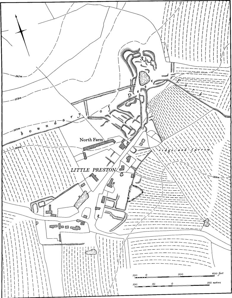
Fig. 126 Preston Capes (2) Settlement remains at Little Preston, (3) Site of manor house, (4) Deer park
b(5) Fishponds (SP 579549; Fig. 128), just below the spring-line at the foot of the steep slope E. of the castle (1) and Manor Farm, on clay at 137 m. above OD. They consist of two rectangular ponds, each with an earthen dam at least 1.5 m. high at its E. end. The ponds have been deepened so they have steep sides and flat bottoms; uneven mounds to the N. are probably the original spoil. Within the E. pond there is a long narrow island about 1 m. high with a mound rising to 1.5 m. high at its W. end.
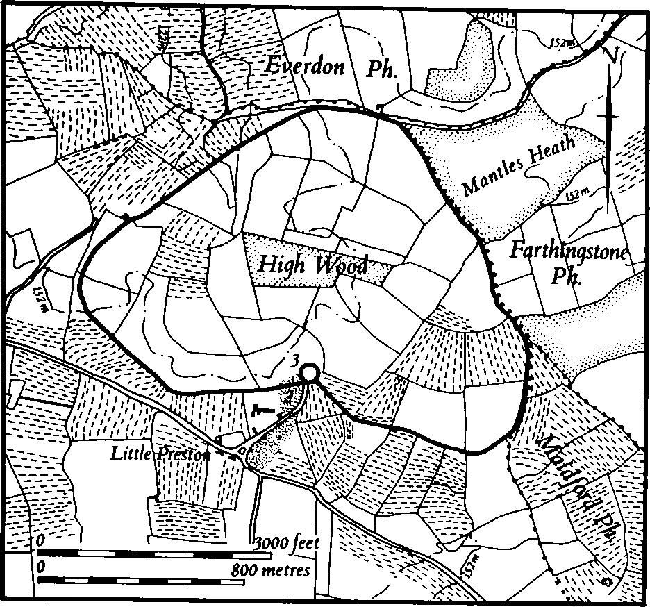
Fig. 127 Preston Capes (4) Deer park
b(6) Banks, quarries and ponds (centred SP 574549), N., W. and S. of the church, on a very steep N.-facing scarp of Upper Lias Clay, between 150 m. and 175 m. above OD. Many of the banks and terraces along this hillside appear to be natural and probably result from landslips which often occur on Upper Lias Clay. Some of the features, however, seem to be man-made, although these are difficult to interpret.
In the S.W. a massive bank 3 m. high and 10 m. wide runs round the hillside near the top of the scarp (SP 573547), with a wide ditch behind it for most of its length. This may be the 'fosse' and 'entrenchement' mentioned by Baker (Hist. of Northants., I (1822–30), 431). On a map of 1742 (NRO) the ditch is shown as a road, then still in use, which together with the existing lane to the S., formed a loop E. of the village stretching as far as Preston Capes Farm.
Close to the church (SP 574548) there appear to be at least two small rectangular ponds, dammed on the N. and perhaps fed by springs which emerge at this height. To the N. of the church and rectory there are two large terraces which, although they appear man-made, are probably at least in part natural. In 1742 these lay in Home Close.
b(7) Settlement remains (SP 575546), lie in the S.W. corner of the village, on Boulder Clay at 180 m. above OD. The earthworks consist of a broad hollow-way running N.–S., parallel to and 100 m. W. of the existing through-road, and continuing the line of the present culde-sac S. of the church. On both sides of the hollow-way, at its N. end, are low banks and other slight features, possibly the remains of former houses. The interest of these remains is that they imply an older arrangement of the village based on a regular grid pattern of streets which bore little or no relationship to the uneven topography on which it lay. The remains had already been abandoned by 1742 (Map in NRO).
b(8) Windmill mound (SP 57605438), lies S. of the village on the E. side of the road to Canons Ashby, on Boulder Clay at 182 m. above OD. It is a large circular mound 1.5 m. high and 11 m. in diam. and has a flat top 4 m. across with a slight depression in the centre. There is no evidence for a surrounding ditch. Its W. side has been cut by the modern hedge-bank and to the E. the adjacent ridge-and-furrow terminates about 8 m. short of the mound. The windmill had already gone by 1742 for a map of that date (NRO) shows nothing on the site.
b(9) Windmill mound (?) (SP 58295398), lies S.W. of Little Preston on the S. side of an E.–W. ridge on Boulder Clay at about 165 m. above OD. The circular mound 20 m. in diam. has been almost completely ploughed away. It was formerly surrounded by ridge-and-furrow, now destroyed, but even on air photographs taken in 1947 it is impossible to ascertain the relationship of the mound to the ridge-and-furrow. It is most likely to be the site of a medieval windmill, though no trace of any structure has been noted. On the Tithe Map of Little Preston, 1838 (NRO) the field in which the mound lies is called Great Mill Field (RAF VAP CPE/UK/1994, 2159–60).
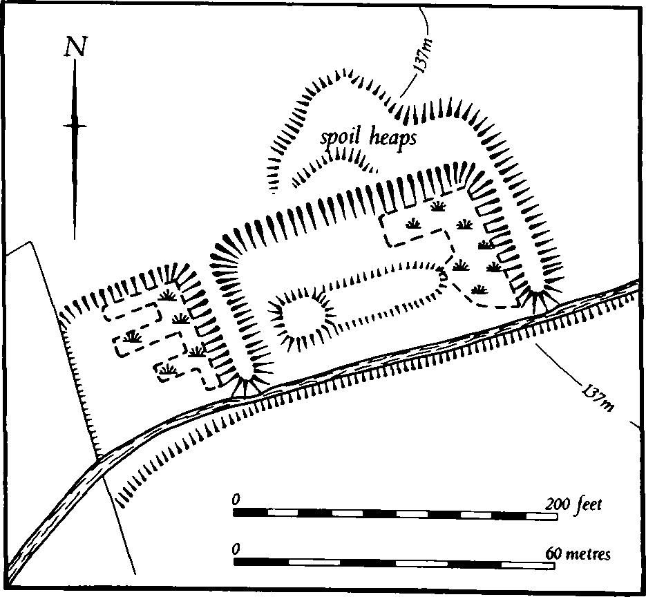
Fig. 128 Preston Capes (5) Fishponds
(10) Cultivation remains. The common fields of Preston Capes were enclosed in 1659 (J. Bridges, Hist. of Northants., I (1791), 80). Ridge-and-furrow of these fields remains on the ground or can be traced on air photographs over most of the parish. On the gently undulating ground in the S. half of the parish and in the extreme N. below the Lias Clay the ridge-and-furrow is generally in rectangular furlongs with the ridges laid out at right-angles to the contours. Along the scarp itself the land is either too steep ever to have been ploughed or has a pattern of furlongs radiating around the spurs. The best remaining areas of ridge-and-furrow are S. of the village (e.g. SP 576543 and 576534) and N. of the village (e.g. around SP 573553).
The date of the enclosure of the common fields of Little Preston is not known, but Bridges (op. cit.) said that it had taken place long before 1659. Ridge-and-furrow of these fields exists on the ground or is visible on air photographs over most of the land associated with Little Preston except on some of the steeper hillsides which were never cultivated (e.g. SP 588551). As at Preston Capes, on the flatter ground S. of the village the ridge-and-furrow is mainly in rectangular interlocked furlongs, but on the more broken ground to the N., radiating furlongs are common. Ridge-and-furrow is particularly well preserved around Little Preston itself. Within the deer park (4) which occupied most of the land N. of Little Preston much ridge-and-furrow remains. It is not clear whether this is earlier or later than the park which was created in 1227 (RAF VAP CPE/UK/1994, 2155–61, 3153–5, 4160–6).