An Inventory of the Historical Monuments in the County of Northamptonshire, Volume 3, Archaeological Sites in North-West Northamptonshire. Originally published by Her Majesty's Stationery Office, London, 1981.
This free content was digitised by double rekeying. All rights reserved.
'Spratton', in An Inventory of the Historical Monuments in the County of Northamptonshire, Volume 3, Archaeological Sites in North-West Northamptonshire(London, 1981), British History Online https://www.british-history.ac.uk/rchme/northants/vol3/pp172-175 [accessed 30 April 2025].
'Spratton', in An Inventory of the Historical Monuments in the County of Northamptonshire, Volume 3, Archaeological Sites in North-West Northamptonshire(London, 1981), British History Online, accessed April 30, 2025, https://www.british-history.ac.uk/rchme/northants/vol3/pp172-175.
"Spratton". An Inventory of the Historical Monuments in the County of Northamptonshire, Volume 3, Archaeological Sites in North-West Northamptonshire. (London, 1981), British History Online. Web. 30 April 2025. https://www.british-history.ac.uk/rchme/northants/vol3/pp172-175.
In this section
56 SPRATTON
(OS 1: 10000 a SP 77 SW, b SP 76 NW)
The modern parish covers some 760 hectares. It formerly included the now deserted village of Little Creaton and its land, which today lie in the parish of Creaton (10) (Fig. 14). Spratton parish, bounded by two small S.-flowing streams which meet in the S.E. corner, occupies a S.-facing spur between 70 m. and 135 m. above OD. The summit of the spur is capped by Northampton Sand which outcrops at about 100 m. above OD. Below, covering most of the lower slopes, are extensive areas of Upper Lias Clay. The Northampton Sand deposits have enabled a number of important sites (1, 3–5, 7) to be revealed by air photography, either as cropmarks or as soil-marks.
Prehistoric and Roman
Fig. 131 Sibbertoft (9) Settlement remains
A barbed-and-tanged arrowhead was found at SP 71547058 in 1970 and a fragment of a polished stone axe is also recorded 'from Spratton' (NM Records). A coin of Marcus Aurelius was discovered somewhere in the parish before 1712 (J. Morton, Nat. Hist. of Northants. (1712), 532).
a(1) Trackway and enclosures (centred SP 716706; Fig. 132), lie immediately N. of the village of Northampton Sand between 114 m. and 125 m. above OD. Air photographs (in NMR) show cropmarks covering some 6 hectares. A large roughly trapezoidal enclosure about 1.5 hectares in area is bounded on its N.W. side by a length of ditched trackway (from SP 71507059 to 71667076) and on the S. by a group of smaller, interlocked enclosures and ditches. Its W. side is intersected by a further group of small enclosures. Two ring ditches are faintly visible in the interior (SP 71637065; BNFAS, 5 (1971), 42).
a(2) Flint-working site (SP 714705), lies W. of (1) on Northampton Sand at 135 m. above OD. A large number of worked flints, said to be of Bronze Age type, have been found (Northants. Archaeol., 11 (1976), 184; inf. D. N. Hall).
a(3) Enclosures (centred SP 711702; Fig. 132), lie immediately W. of the village, 400 m. S.W. of (2) and in a similar situation. Cropmarks are visible on air photographs (in NMR) over an area of about two hectares. There appear to be two sub-rectangular enclosures, each of about 0.5 hectare, separated by what may be a ditched trackway. The N. one contains a small irregular enclosure in its N. corner and a number of possible internal ditches. A small enclosure and linear ditches lie to the W. The S. enclosure has no interior features, but is cut by a linear ditch on its W. side. To the E. is another group of ditches, none of which is clear on available air photographs (BNFAS, 6 (1971), 16, Spratton (2)).
a(4) Enclosure (SP 712708), lies 300 m. N.W. of (2) and in a similar situation. Air photographs (in NMR) show cropmarks of a large rectangular enclosure, about 1.5 hectares in area (BNFAS, 6 (1971), 16, Spratton (1)). Further enclosures and ditches are said to be visible to the S., at SP 711706, but these appear to be frost-wedges (BNFAS, 5 (1971), 42).
a(5) Ring ditch (SP 72707124), lies in the N. of the parish, on clay at 95 m. above OD. Air photographs (not seen by RCHM) are said to show cropmarks of a ring ditch (BNFAS, 2 (1967), 32, Brixworth; 6 (1971), 17, Spratton (4)).
a(6) Linear ditch (SP 733705), in the E. of the parish, close to the Brixworth boundary, on Upper Lias Clay, at 83 m. above OD. Air photographs (in NMR) show cropmarks of an irregular linear ditch, visible for 150 m., running N.–S. almost parallel to the contours. Other vague cropmarks in the area may be connected with it.
b(7) Prehistoric settlement (SP 729691), in the S.E. of the parish on Boulder Clay at 85 m. above OD. A large quantity of worked flints, said to be of Bronze Age type, and Iron Age pottery, have been found (inf. D. N. Hall; for Saxon finds from this site, see (12)).
b(8) Prehistoric and Roman settlement (?) (SP 715685), in the extreme S. of the parish, close to a stream, on gravel at 80 m. above OD. Air photographs (in NMR) show faint cropmarks of what appear to be irregular and sub-rectangular enclosures. Worked flints of Neolithic and Bronze Age types and two Roman sherds have been found in the vicinity (BNFAS, 2 (1967), 19, 32; 6 (1971), 16; Northants. Archaeol., 11 (1976), 184; OS Record Cards).
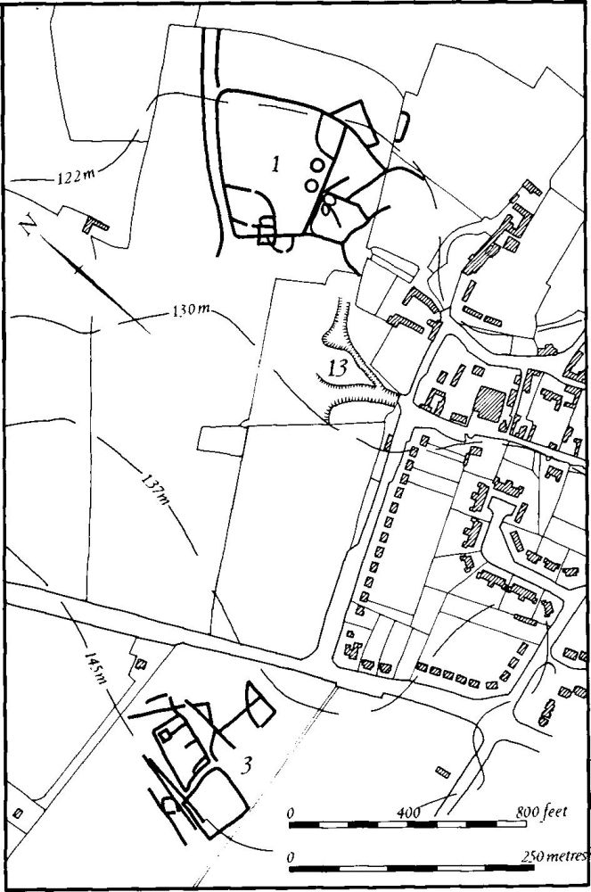
Fig. 132 Spratton (1, 3) Cropmarks, (13) Hollow-ways
b(9) Roman settlement (?) (SP 708691), in the S.W. of the parish, on gravel at 95 m. above OD. Roman colour-coated sherds have been found during field-walking (BNFAS, 5 (1971), 25).
b(10) Roman settlement (SP 731689), in the S.E. of the parish, on Boulder Clay at 90 m. above OD. Roman pottery indicating a small settlement has been found (inf. D. N. Hall).
Medieval and Later
b(11) Saxon settlement (?) (SP 728699), E. of the village, on Boulder Clay at 97 m. above OD. Early Saxon pottery has been found (inf. D. N. Hall).
b(12) Saxon settlement (?) (SP 729691), found with the prehistoric material at (7) above. Early Saxon pottery has been discovered (inf. D. N. Hall).
ab(13) Hollow-ways (SP 715704 and 718697; partly on Fig. 132), lie at the extreme N. and S. ends of Spratton village and, though of minor interest as earthworks, help to explain the morphology of the present village. Until modern development extended the village to the W., Spratton lay some distance away from the main Northampton–Leicester road and consisted of three roughly parallel lanes orientated N.W.–S.E., cut obliquely by the Brixworth-Hollowell road. The existence of a deep hollow-way at the N. end of the village which continued the present High Street northwards, and another at the S. end of Church Road extending S. as a series of old rutted trackways for some 400 m., indicates that the village once lay on a N.–S. road later replaced by the modern one to the W. (RAF VAP CPE/UK/1994, 2370–1).
a(14) Enclosures (SP 718705), lie immediately N.E. of Spratton Hall, on Northampton Sand at 114 m. above OD. The mutilated remains of a series of small paddocks and closes, bounded by low banks and shallow ditches, may be associated with the former manor house nearby.
(15) Cultivation remains. The common fields of the parish were enclosed by an Act of Parliament of 1765. No Enclosure Map has survived but from the evidence of the Enclosure Award (NRO) there were five open fields in 1765, North Rye Field N.W. of the village, South Rye Field to the S.W., Bridge Field to the S., Middle Field to the S.E. and Wood Field to the E. and N.E. Ridge-and-furrow of these fields remains on the ground or can be traced on air photographs over most of the parish. On the flatter ground along the streams in the S. and E. it is mainly arranged in rectangular interlocked furlongs, but along the steeper slopes around the village and in the W. it tends to lie across the contours in end-on furlongs. Complete vertical air photographic cover was not available to the Commission (RAF VAP CPE/UK/1994, 2368–73, 4373–6).