An Inventory of the Historical Monuments in the County of Northamptonshire, Volume 3, Archaeological Sites in North-West Northamptonshire. Originally published by Her Majesty's Stationery Office, London, 1981.
This free content was digitised by double rekeying. All rights reserved.
'Stanford-on-Avon', in An Inventory of the Historical Monuments in the County of Northamptonshire, Volume 3, Archaeological Sites in North-West Northamptonshire(London, 1981), British History Online https://www.british-history.ac.uk/rchme/northants/vol3/pp175-178 [accessed 30 April 2025].
'Stanford-on-Avon', in An Inventory of the Historical Monuments in the County of Northamptonshire, Volume 3, Archaeological Sites in North-West Northamptonshire(London, 1981), British History Online, accessed April 30, 2025, https://www.british-history.ac.uk/rchme/northants/vol3/pp175-178.
"Stanford-on-Avon". An Inventory of the Historical Monuments in the County of Northamptonshire, Volume 3, Archaeological Sites in North-West Northamptonshire. (London, 1981), British History Online. Web. 30 April 2025. https://www.british-history.ac.uk/rchme/northants/vol3/pp175-178.
In this section
57 STANFORD-ON-AVON
(OS 1: 10000 a SP 67 NW, b SP 57 NE, c SP 68 SW, d SP 58 SE)
The triangular parish covers just over 850 hectares S.E. of the R. Avon, which here forms the Leicestershire boundary. Most of the parish is low-lying, between 95 m. and 120 m. above OD, on Upper Lias Clay and river gravels. In the extreme E., however, the land rises steeply to 170 m. above OD, to the W. edge of the Hemplow Hills. Middle Lias Clay outcrops along the face of this scarp; the higher land beyond is covered by Boulder Clay. The two Roman sites (2, 3) discovered recently during field-walking may well be among others still unrevealed.
The parish includes the site of the deserted village of Downtown (6); the latter, and Stanford itself which is also deserted (4), constitute the major monuments in the parish. Downtown has been almost totally destroyed by ploughing but Stanford is well preserved.
Prehistoric and Roman
d(1) Enclosures and ditches (?) (SP 597800), in the N. of the parish, close to Stanford Reservoir, on clay at 114 m. above OD. Air photographs (in NMR) show indistinct traces of a ditch or enclosure with perhaps at least two sub-rectangular enclosures to the E.
a(2) Roman settlement (SP 617787), in the S.E. of the parish, on clays and silts at 150 m. above OD. A Roman site, said to stretch for at least 400 m. along the contours of the hill, was discovered by field-walking in 1975. No other details are known (Northants. Archaeol., 10 (1975), 162).
b(3) Roman settlement (?) (SP 592784), in the S.W. of the parish, on Lower Lias Clay at 105 m. above OD. A scatter of Roman pottery has been found (Northants. Archaeol., 12 (1977), 215).
Medieval and Later
b(4) Deserted village of Stanford (SP 589788; Fig. 133; Plate 14), lies alongside the R. Avon, on river gravel at 100 m. above OD. The village of Downtown (6), now also deserted, is apparently included with Stanford in all the national taxation records and thus the true size of the latter settlement cannot be ascertained.
Stanford and, presumably, Downtown are listed in Domesday Book as one manor held by Guy de Reinbuedcurt with a recorded population of 22 including a priest (VCH Northants., II (1906), 343–4). The next record of population is not until 1377 when, from both places, 131 people over the age of 14 paid the Poll Tax (PRO, E179/155/28). In 1674, 34 households paid the Hearth Tax (PRO, E179/255/14), and this figure is probably for Stanford alone, Downtown by then being completely abandoned. Bridges (Hist. of Northants., I (1791), 578), writing in the early 18th century, said that there were then 15 houses and a shepherd's cottage at Stanford, a statement which seems to be at variance with the Hearth Tax returns 50 years earlier. Although Stanford Hall was built between 1697 and 1700, to the W. of the village, in Leicestershire, it cannot have affected the size of the village, nor is it likely that the mid 18th-century emparking around the hall had a great influence, as it never extended further E. than the main N.–S. road. In 1801 the population for the whole parish was only 45 and this indicates that the village was then about the same size as it was in Bridges' day. By the early 19th century (OS 1st ed. 1 in. map (1834)) the village was much as it is now; in 1831 only 24 people lived in the parish. Since that time one or two cottages have disappeared but new estate buildings have replaced them.
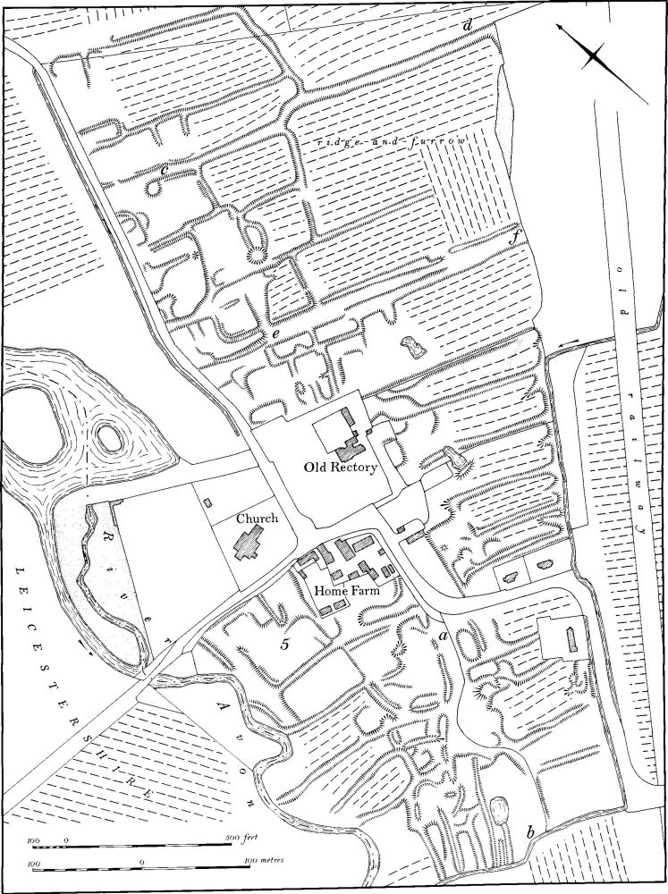
Fig. 133 Stanford-on-Avon (4) Deserted village of Stanford-on-Avon, (5) Site of manor house
It is probable that the village was largely depopulated in late medieval times, perhaps by Selby Abbey (Yorkshire) which held the manor until the Dissolution, or by the Cave family who bought it in 1540. If this supposition is correct, enclosure for sheep may have been the reason behind the abandonment of Stanford.
The remains cover some 24 hectares and are in good condition. It appears that the village lay along a roughly N.E.–S.W. road, of which the present road N. of the church is the modern successor. To the S. of the church the line of the original road cannot be traced but it perhaps ran S. between the house-sites and closes S. of Home Farm ('a'–'b' on plan).
At the N. end of the village, on the S.E. side of the modern road, is a series of mutilated house-platforms set within small rectangular ditched paddocks with other closes behind them. All these back closes have ridge-and-furrow within them, and two hollow-ways ('c'–'d' and 'e'–'f' on plan) pass between them with subsidiary lanes branching off to N. and S. To the W. of the modern road there is no trace of any remains and this pattern, of a village on only one side of its main street, has a parallel at Mallows Cotton (RCHM Northants., I (1975), Raunds (19)) and at Braunston Cleves (Braunston (3)). An even better example is perhaps Canons Ashby (1) where the N. part of the village was also confined to one side of the street. At Canons Ashby there is evidence that this area was a late addition to the original village, and this may also be the case at Stanford.
Further S., to the E. and S.E. of the Old Rectory, is another group of narrow closes, all with ridge-and-furrow within them. These are probably the back paddocks of houses which stood on the site of the rectory and along the road to the S. To the S. again, on either side of the assumed street ('a'–'b' on plan), are the very mutilated remains of what appear to be house-sites, again with long closes containing ridge-and-furrow behind them. To the N., immediately S. of the church and W. of Home Farm, is the alleged site of the manor house (5) (RAF VAP 106G/UK/636, 3165–6; CUAP, WR58–61, AGU83–5, AKP53, AXV37–42, BEJ31; air photographs in NMR).
b(5) Manor house site (SP 588787; Fig. 133), lies within the deserted village (4), immediately S. of Stanford church. Bridges (Hist. of Northants., I (1791), 578) said that the old manor house formerly stood near the church and had been pulled down 'of these late years'. It was presumably removed when the present Stanford Hall was built to the N.W., on the Leicestershire side of the R. Avon, between 1697 and 1700. Two sub-rectangular closes bounded by low scarps and shallow ditches, and a number of indeterminate banks, is all that remains on the ground at the assumed site but these are very different in form and plan from the recognisable village remains to the S., and there is no reason to doubt that they represent the site of the manor house (RAF VAP 106G/UK/636, 3165–6; CUAP, AGU85, AXV42).
c(6) Deserted village of Downtown (SP 615801; Fig. 134; Plate 5), lies in the N.E. of the parish on Middle and Lower Lias Clay and river gravels between 120 m. and 132 m. above OD. The site survived until 1963 in a very good state of preservation but was then completely destroyed by ploughing. The plan is based on one made by the OS before destruction, supplemented by information from air photographs and fieldwork.
The history of the village is largely unknown and for all the medieval period it is included in the national taxation records with Stanford (4) of which it is perhaps a secondary settlement. It was certainly completely abandoned by the early 18th century, for Bridges (Hist. of Northants., I (1791), 578), writing in about 1720, recorded the site and said that 'large foundation stones and causeys' had been turned up by the plough. There was, apparently, a chapel in the village, dependent on the church at Stanford.
Before destruction the site was in good condition except that the Grand Union Canal had been cut across the N.E. part. It consisted of a broad central hollow-way ('a'–'b' on plan), bounded on each side by a series of rectangular closes with probable house-platforms at the ends near the hollow-way. Some of the closes had traces of ridge-and-furrow within them, but this does not appear to have overlaid any of the village earthworks. Pottery of the 12th to 14th centuries has been found on the site (K. J. Allison et. al., The Deserted Villages of Northants. (1966), 38; Med. Arch., 12 (1968), 201; Antiquity, 45 (1971), 298–9; DMVRG, Annual Rep., 15 (1967), 4; CUAP, AGV7, AHT48, AIH34).
(7) Cultivation remains. The date of enclosure of the common fields of Stanford and Downtown is unknown and there is no indication as to whether each village had a separate field system. It is probable that such fields were enclosed before or during the 16th century. Ridge-and-furrow can be traced on the ground or from air photographs throughout almost the entire parish. Across the broken ground in the E., on the edge of the Hemplow Hills, the furlongs are short and interlocked but on the gentle lower slopes they are all end-on, running N.W.–S.E. Further N. and W., on the flatter ground near the river, the ridges are longer but the blocks are again interlocked. Around the site of the deserted village of Downtown (6) much of the known ridge-and-furrow has recently been destroyed but in the parkland around Stanford itself the ridges ares still well preserved (RAF VAP 106G/UK/636, 4163–7, 3162–9).
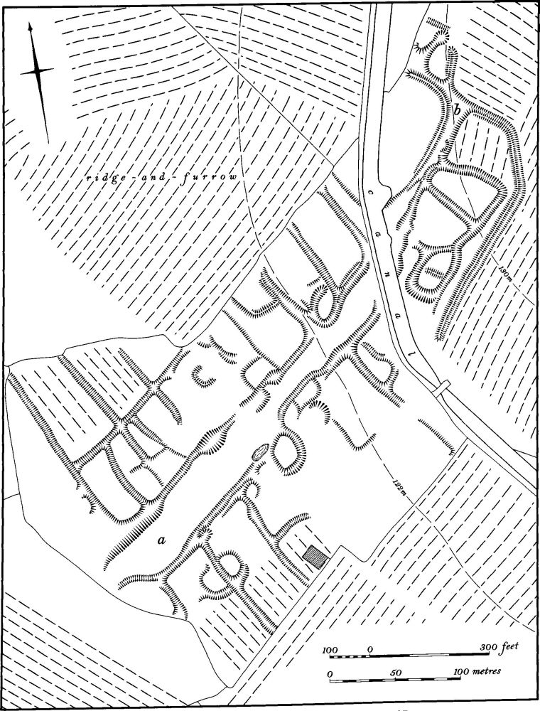
Fig. 134 Stanford-on-Avon (6) Deserted village of Downtown