An Inventory of the Historical Monuments in the County of Northamptonshire, Volume 3, Archaeological Sites in North-West Northamptonshire. Originally published by Her Majesty's Stationery Office, London, 1981.
This free content was digitised by double rekeying. All rights reserved.
'Welford', in An Inventory of the Historical Monuments in the County of Northamptonshire, Volume 3, Archaeological Sites in North-West Northamptonshire(London, 1981), British History Online https://www.british-history.ac.uk/rchme/northants/vol3/pp195-198 [accessed 30 April 2025].
'Welford', in An Inventory of the Historical Monuments in the County of Northamptonshire, Volume 3, Archaeological Sites in North-West Northamptonshire(London, 1981), British History Online, accessed April 30, 2025, https://www.british-history.ac.uk/rchme/northants/vol3/pp195-198.
"Welford". An Inventory of the Historical Monuments in the County of Northamptonshire, Volume 3, Archaeological Sites in North-West Northamptonshire. (London, 1981), British History Online. Web. 30 April 2025. https://www.british-history.ac.uk/rchme/northants/vol3/pp195-198.
In this section
64 WELFORD
(OS 1: 10000 a SP 68 SW, b SP 68 SE, c SP 67 NW, d SP 67 NE)
The parish, covering 1260 hectares, lies on the S. side of the R. Avon which forms the N.E. and N.W. boundaries. Most of it is on gently undulating Upper and Middle Lias Clay between 120 m. and 150 m. above OD though much of the area has been covered by superficial deposits of Boulder Clay. In the W. and N. the land is higher and more broken and several small streams flow N. and W. to the R. Avon in steep-sided valleys. The major monument is the settlement remains (13) which suggest that the present village of Welford may have developed from an early planned layout.
Prehistoric and Roman
A few worked flints have been found in the E. of the parish (SP 65407985; Northants. Archaeol., 10 (1975), 152).
a(1) Enclosure (SP 624823), in the N. of the parish, between the R. Avon and the Grand Union Canal, on alluvium at 120 m. above OD. Air photographs (in NMR) show a small, almost square enclosure with rounded corners; a ditch runs W. from the S.W. corner (Northants. Archaeol., 8 (1973), 26).
a(2) Ditched trackway and enclosures (centred SP 625817; Fig. 144), in the N. of the parish, on clays and silts at 140 m. above OD. Air photographs (in NMR) show very faint cropmarks of a ditched trackway (SP 62308175–62508175). On its S. side at least three sub-rectangular enclosures, and ditches which may be parts of other interlocking enclosures can be detected (Arch. J., 121 (1964), 22; Northants. Archaeol., 8 (1973), 26). Some of the photographs also show uneven patches in the crops in the field immediately to the S.E. (SP 626815). A scatter of Roman pottery has been found close by (SP 624818; Northants. Archaeol., 12 (1977), 223).
a(3) Ring ditch (SP 628811; Fig. 144), 600 m. S.E. of (2) on clays and silts at 145 m. above OD. Air photographs (in NMR) show cropmarks of a possible ring ditch (Northants. Archaeol., 8 (1973), 26).
a(4) Linear ditches (SP 631814; Fig. 144), W. of Welford Lodge and 350 m. N.E. of (3) on Boulder Clay at 145 m. above OD. Air photographs (in NMR) show a system of interconnecting linear ditches, which perhaps form irregular enclosures.
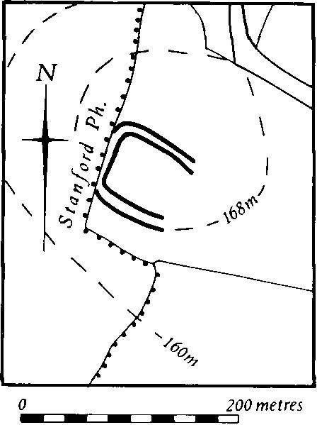
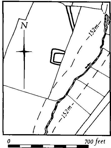
Fig. 145 Welford (5, 6) Cropmarks
a(5) Double-ditched enclosure (sp 620802; Fig. 145), against the W. boundary of the parish, on a steep-sided spur known as Downtown Hill, on clays and silts at 168 m. above OD. Air photographs (in NMR) show three sides of a sub-rectangular double-ditched enclosure covering about 0.75 hectare. The enclosure is overlaid by ploughed-out ridge-and-furrow which obscures any trace of a S.E. side.
c(6) Enclosure (?) (SP 635799; Fig. 145), S.W. of the village, on clays and silts at 152 m. above OD, on the crest of a small hill. Air photographs (in NMR) show a possible double-ditched enclosure. It is not clear, however, and may be a random effect, incorporating the cropmarks of ridge-and-furrow (for Saxon pottery from this site, see (10)).
a(7) Iron Age and Roman settlement (?) (SP 637810), N.W. of the village, on the S. side of the R. Avon, on Boulder Clay at 140 m. above OD. Iron Age and Roman pottery have been found here (Northants. Archaeol., 12 (1977), 223; for Saxon material from this site, see (11)).
c(8) Roman settlement (?) (SP 643786), in the S. of the parish, on Boulder Clay, at 156 m. above OD. Roman pottery has been noted (Northants. Archaeol., 12 (1977), 223).
a(9) Roman settlement (?) (SP 64268061 and 64368072), within the N. part of the village on clay at about 135 m. above OD. A few sherds of Roman pottery were found on building sites in 1973 and 1974 (Northants. Archaeol., 9 (1974), 101; 10 (1975), 163).
Medieval and Later
A Saxon brooch described as 'circular ... enriched with delicate filagree and pearls' is said to have been found at Welford in about 1853. This may be a surviving brooch said to be from Husbands Bosworth (Arch. J., 10 (1853), 362; Meaney, Gazetteer, 196).
c(10) Saxon settlement (?) (SP 635799), near the possible enclosure (6). Early Saxon sherds have been noted (Northants. Archaeol., 12 (1977), 223).
a(11) Saxon settlement (?) (SP 637810), on the same site as the Iron Age and Roman settlement (7). Early Saxon pottery has been found (Northants. Archaeol., 12 (1977), 233).
a(12) Saxon settlement (?) (SP 629802), W. of the village, on clay at 157 m. above OD. A scatter of early Saxon pottery has been discovered (Northants. Archaeol., 12 (1977), 223).
a(13) Settlement remains (centred SP 639804; Figs. 12 and 146), lie N.W. of the existing village, mainly on Boulder Clay between 135 m. and 150 m. above OD. The earthworks, although not of outstanding importance in themselves, do add to the understanding of the development of the village. The main feature is a broad hollow-way ('a'–'b' on plan) up to 1.5 m. deep which runs N.E.–S.W., roughly parallel to the existing West Street and High Street. Its N.E. end has been destroyed by a modern housing estate. On both sides of the hollow-way are rectangular closes or paddocks, bounded by ditches or scarps and banks which may be former house-sites though some have been overploughed by ridge-and-furrow. Ridge-and-furrow also exists within long closes to the N.W. which extend into the valley bottom.
Without taking into consideration the earthworks it would be possible to interpret the village plan as a single street along the Northampton-Leicester road with a back lane to the N.W. However, the existence of the hollow-way with possible house-sites along it indicates that the village was perhaps once made up of three parallel streets, and that the central one, West Street, with both the church and the manor house (14) situated on it, was originally the main one. Such a layout could have been the result of planning rather than gradual growth. All the earthworks were already abandoned by 1838 (NRO, Map of Welford; see also Tithe Map of 1848).
At the N. end of the village, on the S.E. side of High Street (not shown on plan; SP 644805), is another group of abandoned closes and a small embanked pond. These appear to be the remains of gardens behind houses which once stood along the High Street (CUAP, XT72–4 and air photographs in NMR).
a(14) Manor house site (SP 639802; Fig. 146), lies W. of the church, on the W. side of West Street, on Boulder Clay at 150 m. above OD. Little is known of its history, but village tradition asserts that an old hall stood on the site. More convincing is the fact that on the Tithe Map of 1848 (NRO) the field was called Hall Field. The area has recently been completely built over and the earthworks on Fig. 146 are those recorded by the OS before destruction, but the site had already been levelled for a cricket ground before the modern housing was constructed and the earthworks illustrated must have been only a fragment of what once existed. All that can be said is that two large mounds lying against the road appear, from air photographs, to have been the remains of a flat terrace-walk of the type usually interpreted as characteristic of 17th or early 18th-century gardens. On a map of 1838 and on the Tithe Map of 1848 (both in NRO) a building is marked in the N.E. corner of the area and two others are shown along the W. boundary.
Beyond this boundary, in a field called Lady Close in 1848, some irregular closes or paddocks survive, the lower parts of which have ridge-and-furrow either within them or riding over them. These earthworks are likely to be part of the manorial complex (CUAP, XT73–4 and air photographs in NMR).
a(15) Fishpond (SP 640807; Fig. 146), lies N.W. of the N. end of the village, in the bottom of a steep-sided N.E.-draining valley, on Lias Clay at 130 m. above OD. It consists of a roughly rectangular area, embanked on the N.W. and S.E. sides and with a massive dam up to 3 m. high on the N.E. In the centre is a small rectangular island 1.5 m. high. The modern stream flows to the N.W. of the pond, but originally the water left the stream some 200 m. to the S.W. and flowed in a narrow channel to a point just S.W. of the pond. There the channel forked, one branch entering the pond and so filling it, the other passing along the S.E. side as an overflow channel, leading back to the stream. Nothing is known of the pond's history (Northants. P. and P., 4 (1971), 309; CUAP, XT74 and air photographs in NMR).
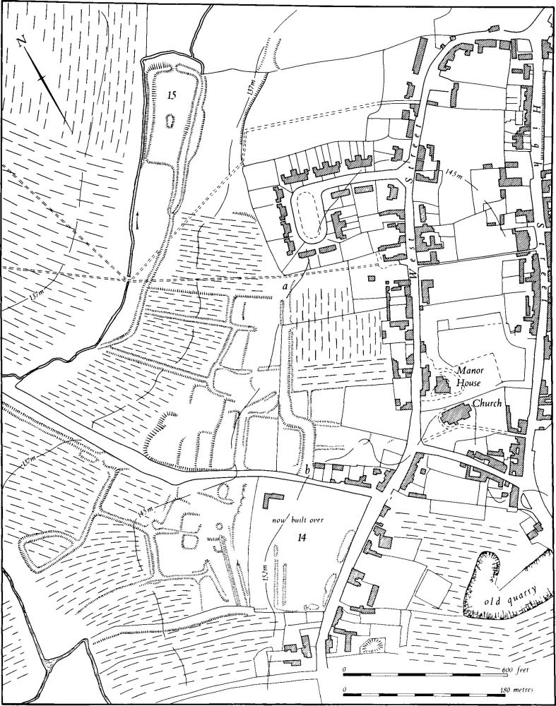
Fig. 146 Welford (13) Settlement remains, (14) Site of manor house, (15) Fishponds
a(16) Mound (SP 61938080), in the W. of the parish, on Middle Lias Clay at 130 m. above OD. It is roughly circular, 10 m. in diam. and 0.75 m. high, with no visible ditch and is probably relatively modern (Northants. Archaeol., 10 (1975), 175).
(17) Cultivation remains. An Act of Parliament for the enclosure of the common fields of the parish was passed in 1777, but only about half the area was involved. Even in the early 18th century Bridges (Hist. of Northants., I (1791), 591) recorded that only 53 'yardlands' were in tillage, the rest was enclosed. However, the parish was not enclosed in 1602 (Northants. P. and P., i (1949), 29). Ridge-and-furrow exists on the ground or can be traced on air photographs over much of the parish. On the flatter ground in the S. it is arranged in generally interlocked furlongs often of markedly reversed-S form. On the broken land in the N.W., however, a much more complex pattern occurs as the furlongs are adapted to the steep valley sides and indented scarps; radiating arrangements and long runs of end-on furlongs are common. Considerable areas of ridge-and-furrow are well preserved around the village itself, not only within the settlement remains (13) but also in old paddocks E. of the village (RAF VAP 106G/UK/636, 3169–78 and air photographs in NMR).