An Inventory of the Historical Monuments in the County of Northamptonshire, Volume 3, Archaeological Sites in North-West Northamptonshire. Originally published by Her Majesty's Stationery Office, London, 1981.
This free content was digitised by double rekeying. All rights reserved.
'Winwick', in An Inventory of the Historical Monuments in the County of Northamptonshire, Volume 3, Archaeological Sites in North-West Northamptonshire(London, 1981), British History Online https://www.british-history.ac.uk/rchme/northants/vol3/pp199-201 [accessed 30 April 2025].
'Winwick', in An Inventory of the Historical Monuments in the County of Northamptonshire, Volume 3, Archaeological Sites in North-West Northamptonshire(London, 1981), British History Online, accessed April 30, 2025, https://www.british-history.ac.uk/rchme/northants/vol3/pp199-201.
"Winwick". An Inventory of the Historical Monuments in the County of Northamptonshire, Volume 3, Archaeological Sites in North-West Northamptonshire. (London, 1981), British History Online. Web. 30 April 2025. https://www.british-history.ac.uk/rchme/northants/vol3/pp199-201.
In this section
67 WINWICK
(OS 1: 10000a SP 67 SW, b SP 67 NW)
The parish covers about 840 hectares and lies across the valley of a small N.W.-flowing stream which also forms part of the S. boundary. From this central valley, at about 130 m. above OD, the land rises steeply over Lias clays, to a maximum of 168 m. in the S.W. and 190 m. in the N.E., across a rolling landscape drained by several small streams. Much of the area is covered by expanses of Boulder Clay as well as glacial sands and gravels. The major monument is the now almost totally deserted village of Winwick (1), the remains of which extend along the central valley.
Medieval and Later
a(1) Settlement remains (centred SP 627737; Figs. 147 and 148; Plate 14), formerly part of the village of Winwick, extend for almost 1 km. along the valley of the small N.W.-flowing stream beside which the tiny modern village still stands. The earthworks are on Upper and Middle Lias Clay and alluvium, between 125 m. and 145 m. above OD. The village is listed in Domesday Book with a recorded population of 31 (VCH Northants., I (1902), 316, 320, 339, 350, 380). No further details of population are known until the 17th century when 25 people paid the Hearth Tax of 1673 (PRO, E179/254/14), and it is impossible to say whether the extensive remains represent the maximum expansion of the village at any one time or are the result of changes in location or layout over a long period. The latter seems more likely for some of the earthworks in the N.W. have been overploughed with ridge-and-furrow but others, in the S.E., survive as sharply defined features. The village therefore appears to have moved gradually upstream. All these changes had taken place before 1839; the Tithe Map of that date (NRO; Fig. 148) shows the village almost as it is today.
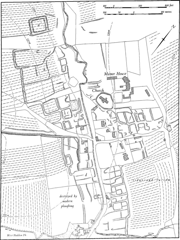
Fig. 147 Winwick (1) Settlement remains
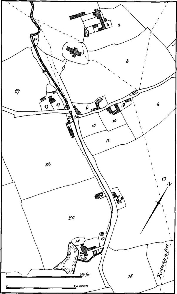
Fig. 148 Winwick (1) Plan of village in 1839 (from Tithe Map in NRO)
At the N.W. end of the site are the remains of a small moated enclosure ('a' on plan) consisting of an island about 40 m. across surrounded by a shallow ditch now less than 1 m. deep. The whole has been overploughed with ridge-and-furrow. S.E. of the moat, still on the S.W. of the stream, is a group of at least three long closes ('b' on plan) with house-sites at their N.E. ends. The closes are sub-divided by low scarps and are bounded by scarps and ditches. The whole area, excluding the house-sites, is covered by later ridge-and-furrow. A wide hollow-way, said locally once to have formed the main approach to the manor house on the other side of the valley, separates these closes from a group of smaller and more sharply defined enclosures ('c' on plan), some of which are embanked as well as ditched. The modern road cuts across the S. corner of this area and probably replaced an earlier route which survives as a hollow-way continuing W. on the general line of the lane as the latter leaves the village. To the S.W. of the lane ('d' on plan) are further closes. These have not been ploughed in ridge-and-furrow but the S. part has now been almost completely destroyed by modern ploughing. On the E. side of the stream, and of the axial road which follows it, is a row of at least seven closes containing house-sites ('e' on plan). These are very well preserved and fragments of post-medieval pottery have been found on them. On the higher ground behind the existing cottages is a further group of ditched and scarped enclosures ('f' on plan). These are bounded on the S.E. by a lane, which continued as a hollow-way across the field to the E., and on the N.W. by a wide hollow-way which runs along the S. side of the large mound on which the church of St. Michael is situated. Two parallel ditches N.W. of the church may define the original driveway to the hall (RAF VAP 541/15, 4383–5; CUAP, AGV14–16, AKP65, AWQ12, 13, XL62, 63).
(2) Cultivation remains. The common fields of the parish were finally enclosed following an Act of Parliament of 1794 but at least part of it was enclosed by 1652. Much of the ridge-and-furrow of these fields has been destroyed particularly in the W. of the parish where only a few furlongs remain, but around and to the N. of the village the layout is recoverable either on the ground or from air photographs. It is arranged in end-on and interlocked furlongs in response to the direction of slope. Behind the empty closes of the deserted village the ridges all run up the slope to the higher ground. It is noteworthy that large parts of the village have been overploughed by later ridge-and-furrow (RAF VAP CPE/UK/1994, 2468–71; 541/15, 4380–8).