An Inventory of the Historical Monuments in the County of Northamptonshire, Volume 3, Archaeological Sites in North-West Northamptonshire. Originally published by Her Majesty's Stationery Office, London, 1981.
This free content was digitised by double rekeying. All rights reserved.
'Appendix: Roman Roads', in An Inventory of the Historical Monuments in the County of Northamptonshire, Volume 3, Archaeological Sites in North-West Northamptonshire(London, 1981), British History Online https://www.british-history.ac.uk/rchme/northants/vol3/pp206-213 [accessed 30 April 2025].
'Appendix: Roman Roads', in An Inventory of the Historical Monuments in the County of Northamptonshire, Volume 3, Archaeological Sites in North-West Northamptonshire(London, 1981), British History Online, accessed April 30, 2025, https://www.british-history.ac.uk/rchme/northants/vol3/pp206-213.
"Appendix: Roman Roads". An Inventory of the Historical Monuments in the County of Northamptonshire, Volume 3, Archaeological Sites in North-West Northamptonshire. (London, 1981), British History Online. Web. 30 April 2025. https://www.british-history.ac.uk/rchme/northants/vol3/pp206-213.
In this section
APPENDIX
ROMAN ROADS
For ease of reference the two Roman roads in the area are described here and not under the parishes through which they pass. The roads are identified by the numbers given to them by I. D. Margary in Roman Roads in Britain, I (1955).
If: WATLING STREET, LILBOURNE – STOW-NINE-CHURCHES (Figs. 155–157).
Watling Street, the main Roman road to London from the N.W., entered the area in the N.W. corner of Lilbourne parish, crossing the R. Avon at the junction of the counties of Northamptonshire, Warwickshire and Leicestershire (SP 543778). The road then climbed southwards out of the Avon valley and ran S.E., exactly straight, for 5 km. across mainly flat ground. Its line is now occupied by the main A5 trunk road which has obliterated all trace of its original form. This section constitutes the county boundary between Warwickshire and Northamptonshire.
The next section of the A5, which is now the approach road to the M1 Crick interchange, to the N.E. of the Railway Hotel, Kilsby (SP 569733), swings away from the Roman road alignment. Here for a distance of 350 m. the original agger is well preserved as an embankment, up to 16 m. wide and 1.25 m. high, with a flat top 5 m. across. There are no traces of side ditches. At the N. end this agger has been damaged by a modern open drain cut into its N.E. edge. Codrington (Roman Roads in Britain (1931), 64), noted that sections through the agger were visible in the side of the ditch but nothing can now be seen. He described them as showing 'gravel a yard deep, with a layer of large cobble stones at the base in the clay sub-soil'. In the 1930s what appeared to be a drain was seen in one of these sections, passing transversely under the agger. It had 'well built vertical walls roofed with flat stones' (Ant. J., 16 (1936), 462–3). From the description this may have been an original drain or culvert but it could alternatively have been part of a post-medieval field drain. Close to this point, at least two burials, thought to be Saxon, have been discovered, one in the centre of the road and one a little to the E. (Crick (6)). During the excavations of the earlier of these burials in 1947 the construction of the Roman road was observed. The road appeared to have been surfaced with a layer of hard-packed gravel some 0.5 m. deep containing 'larger stones laid roughly in two strips' about 0.57 m. apart, 'where ruts may have been filled in'. Below the gravel was a rough pavement of large stones up to 0.3 m. in diam. on the undisturbed ground surface. No trace of a ditch was noted on the E. side of the road when the excavation was extended in that direction (Rugby School Magazine (1948), 34–7). To the S. the agger is truncated by the main Northampton-Rugby road (A428) which crosses it at right-angles (at SP 570729) and modern draingage work beyond has removed any trace. Even the old trackway which once followed the alignment has gone, and only the Crick-Kilsby parish boundary marks its line. In the 1930s (Ant. J., op. cit.) 'a definite low agger' still existed. Further S. the road appears as a slight terrace-way 10 m. wide as it begins to climb the steep N.W. slope of a small spur (sp 573725). From there the alignment is followed by a narrow track which runs on the top of a well-marked ridge up to 1.25 m. high and 12 m.–15 m. wide until it reaches a flat area between two small valleys draining N. and S. Here, at a height of 117 m. above OD, the alignment changes very slightly towards the S., but only by some 2 degrees. This point is visible from the last change of alignment near Gibbet Hill, S. of Lutterworth, Leicestershire. On this new alignment the track continues S.E. until it is cut first by the Northampton-Rugby railway and then partly by the M1 motorway N. of the junction of the latter with the M45. Here, for just over 1 km., the motorway cutting has removed all or most of the remains of the Roman road and later tracks following it. Only the parish boundary marks the original alignment. It is almost certain that it was this part of Watling Street, N. of Watford, which Bridges described in the early 18th century (Hist. of Northants., I (1791), 585). He recorded it as 'rising to near the height of fifteen foot. This bank is above a furlong in length and ten to twelve foot wide. It is composed of gravel, which appears visible on the top'. It is extremely unlikely that the agger was as high as Bridges states, but clearly it was a prominent feature.
Beyond the M45 motorway junction the line of the Roman road is again followed by the present A5 trunk road for some 2.5 km. until the Roman town of Bannaventa (Norton (4)) is reached (SP 610649). Along this section the Roman road ran exactly straight, but although the modern road has minor bends within it the width is such that nowhere is the original agger visible on either side. A little to the N. of the point where the road from Welton to Watford crosses the A5 (SP 595680), the Roman road was described in the late 19th century as being '47–50 feet wide of which 20 feet are flat. The centre appears to have been raised 4 feet to 5 feet 6 inches' (Notes in the Dryden Collection, Central Library, Northampton). However, as by that time the original road had been much altered, it is doubtful whether this is a true description of the Roman road. Close to this point six burials, said to be Anglo-Saxon, were discovered in 1845 on the side of or within the agger (Welton (1)). Another burial, said to be Roman, was discovered further S. in 1976 (SP 608652; Long Buckby (3)). It lay within one of the side ditches of the Roman road. Along this section, the road crosses two small N.W.-flowing streams, presumably over small bridges or culverts, and finally reaches the summit of a low ridge at 125 m. above OD. At this point the modern road swings sharply E. in a broad curve before rejoining the Roman road alignment further S. The Roman road ran straight on and is visible on air photographs (in NMR; CUAP, BCO32–4) as a broad light-coloured band passing through the defences of Bannaventa (Fig. 115). Within the town the road is again visible on air photographs, sometimes as a light area 9 m. wide and sometimes as two parallel ditches 9 m.–10 m. apart. It passes through the town defences near the S. corner, still showing as a pale strip. Immediately beyond, the junction with the Bannaventa-Duston road (17) is visible (see below). Watling Street continues on the same alignment down the hillside, crosses a small E.-flowing brook and meets the A5 trunk road running in from the N.E. (SP 615638). The line of the road through Bannaventa is also partly visible on the ground, under good conditions, as a broad ridge some 10 m.–15 m. across but only a few centimetres high, apparently made of gravel and small pieces of limestone.
From the point of junction, both the A5 and Watling Street run S.E. on the same alignment across gently undulating land to a point near Dial House (SP 622620). Along this section all trace of the Roman road has been obliterated. Anglo-Saxon burials have been found (Norton (9)), immediately E. of the road. Just S.E. of Dial House the modern road swings slightly E. to run down a spur into a small valley, on an easier gradient than the Roman road. Immediately S.W. of the existing road a line of light-coloured stone-rubble reveals the Roman road. At the bottom of the spur the modern road rejoins the Roman road alignment to cross a stream. The latter is small enough to have been crossed by a culvert rather than a bridge. Beyond, the road continues on the same alignment, on level ground, until it crosses another small stream (SP 627611).
The Roman and modern roads now turn on to the first of a series of short straight alignments in order to avoid the junction of the S.-flowing Brockhall Brook and the E.-flowing R. Nene at Weedon Bec. If the original alignment had been continued, the Roman Road would have crossed the R. Nene and also the meandering Brockhall Brook four times within 1.5 km. and to avoid this the diversion to the W. was laid out. The first turn is through some 30 degrees and the road then runs almost due S. for 500 m. to a point just W. of the largest bend of the brook. It then turns back through some 40 degrees (SP 627606) and runs straight for 1050 m. until it reaches the S. end of the main street of Road Weedon (SP 632597). Here the road turns again, further to the S.E. through an angle of about 15 degrees, and runs straight for 850 m., crossing the Nene (at SP 635595), perhaps originally by a ford. The road then crosses another small N.E.-flowing stream and turns again through about 15 degrees on to an alignment close to its original one (SP 639591). The modern road here is on a large embankment up to 2 m. high but it is not clear whether this is a survival of the original road or entirely the result of early 19th-century improvements. The fact that this final alignment is not exactly the same as the original one N. of Weedon may be the result of slightly inaccurate laying out of the Roman road.
For the first 1150 m. of the new alignment the Roman road is totally obscured by the modern road which runs exactly straight. Then, N.E. of Church Stowe, just within Nether Heyford parish (SP 645580), the modern road leaves the Roman road and swings W. in a broad curve to avoid two steep-sided narrow valleys. Up until at least 1773 (NRO, Map of Stowe-Nine-Churches) the road continued along the Roman road alignment. However, between then and 1839 (NRO, Tithe Map of Stowe-Nine-Churches) it was diverted to its present course, presumably by Thomas Telford who regraded and realigned this, the London-Holyhead road, in the early 19th century. This diversion has left the original Roman road largely intact (Fig. 154) as a very spread rounded agger 12 m. wide but only 0.25 m. high running across the corner of two small arable fields and descending into the valley bottom. Just before its reaches the stream (SP 64685786) it becomes a large flat-topped embankment 15 m. across and 1.25 m. high which may be the abutment of a bridge or a causeway across a culvert. It is impossible to be certain of the character of the crossing because an abandoned ironstone tramway running from Stowe-Nine-Churches to the railway sidings at Nether Heyford, crossing the S.E. end at right-angles, has altered its original form.
On the other side of the valley, the agger is again visible in pasture as a slight bank 10 m. wide and 0.25 m. high, traceable for 200 m. as far as the edge of the next valley. This second valley is spanned by a massive embankment up to 30 m. wide at the base and 3.5 m. high with a rounded top 8 m.–10 m. wide. This feature is now in arable land and is much damaged by ploughing; it was probably once considerably larger. The present stream passes through it in a small culvert, presumably on the site of a Roman one.
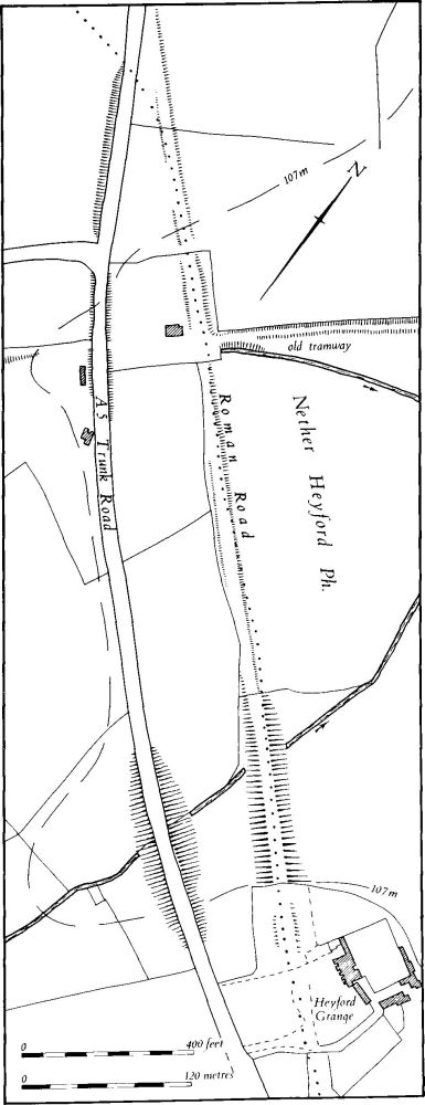
Fig. 154 Roman Road 1f, Watling Street, Embankment in Stowe-Nine-Churches
On the S.E. side of the valley the embankment fades out at the boundary of the garden of Heyford Grange. Within the garden are slight traces of a possible agger continuing along the same alignment until it rejoins the present road near its junction with the lane to Nether Heyford (sp 65025723). From there both the Roman road and the modern A5 follow the same alignment for 850 m., to a point where (at SP 655564) they both pass beyond the boundaries of the area under review.
17 BANNAVENTA-DUSTON (Figs. 156 and 158)
This short length of Roman road linked the town of Bannaventa (Norton (4)) to the important Roman settlement at Duston just W. of Northampton. It branched off Watling Street just S.E. of the S.E. gate of Bannaventa; air photographs (CUAP, BCO32–4) show a short light-coloured strip bounded by side ditches, running E. from its junction with Watling Street (Fig. 115). Beyond this point no traces are visible for nearly 2 km. Its line is crossed by the present A5, two lanes, the railway, the Grand Union Canal and the M1 motorway, all in the space of 600 m., and these have destroyed all remains. To the E. of the motorway the road must have climbed up a gentle W.-facing slope to the present bend in the Duston-Whilton road near Gipsy Spinney (SP 623640), but there is no trace of it on this slope, either on the ground or on air photographs and the later ridge-and-furrow appears to lie across its assumed line. From Gipsy Spinney the modern road follows the Roman road alignment, here running exactly E.S.E. for 550 m. (to SP 638639). For the next 3.2 km., as far as the outskirts of the hamlet of Nobottle (SP 669632), the modern road follows a rather sinuous line and no trace of the Roman road on a straight alignment can be found. However, close examination reveals that the road was made up of a series of short alignments to enable it to remain on the narrow N.W.–S.E. ridge and avoid the numerous steep-sided valleys on either side. The first change of direction occurs near the Norton-Brockhall parish boundary (SP 638639), where the road turns S.E. through about 8 degrees. It then runs straight for 500 m. before turning further S.E. through about 10 degrees to climb on to a higher part of the ridge (SP 643637). The new alignment is very short, only 150 m., and at the end it turns back towards the E. through some 15 degrees (SP 644636). Another straight length 500 m. long follows (to SP 649635), beyond which the road turns again to the S.E. through about 8 degrees. Here the ridge-top is only 150 m. across, and extremely sinuous, and as a result the Roman road had to change direction even more often to remain on the crest. The next alignment is only 150 m. long; the road then turns further S.E. by 5 degrees, runs for 100 m. and turns again by about 5 degrees back to a more easterly alignment (SP 652635). At this point the modern road diverts slightly to the S. and, though the Roman road probably ran on below a headland, the adjacent ridge-and-furrow to the N. has obscured all trace.
The next alignment is just under 500 m. long, then a little to the N.W. of Hillcrest Cottages the road turns sharply E.N.E. through about 25 degrees and runs on a new alignment for 250 m. (to SP 659634). It next turns once more to the S.E. by about 26 degrees, and then, though the modern road bends slightly, the Roman road must have run straight for about 1 km. to the E. end of the ridge above the hamlet of Nobottle (SP 669632). Here the Roman road turned for the last time, further to the S.E. by about 10 degrees. It left the modern road to the N. and presumably ran down the shallow valley at the bottom of which the modern road rejoins it. At this point, N. of the modern road, the boundary bank and ditch of the settlement remains of Nobottle (Brington (4)) have been interpreted as a terraced section of the Roman road (BNFAS, I (1971), 44). However, there is little doubt that the Roman road was in fact to the S. of the present one. Near Townsend Farm in Nobottle the Roman road and the modern one converge and from hereon run S.E. as the main street of Nobottle for 600 m., climbing up a steep valley side. At the top, the modern road runs along the S. side of Nobottle Belt and is made up of three different alignments, but the Roman road apparently ran straight, close to its S. side. However, no trace of the Roman road is visible in the modern arable land. At the S.E. end of the Nobottle Belt (SP 689624) the modern road and the Roman road converge again and cross into Harpole parish, out of the area under review.
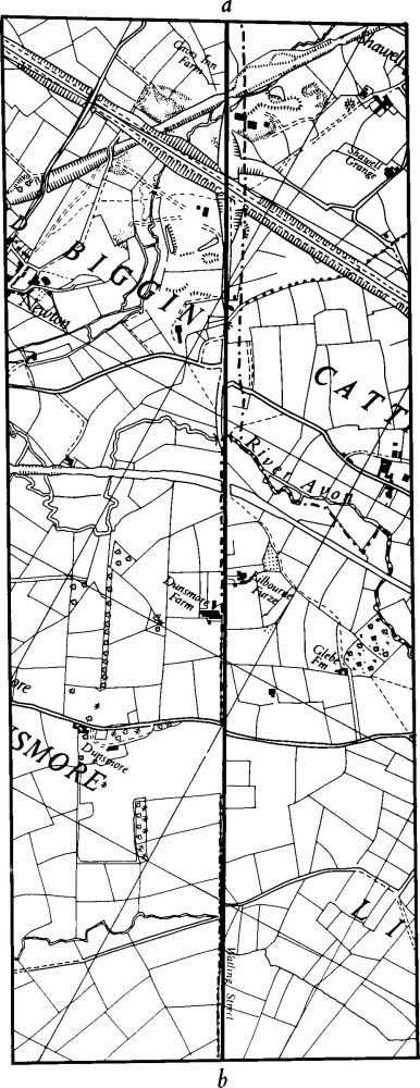
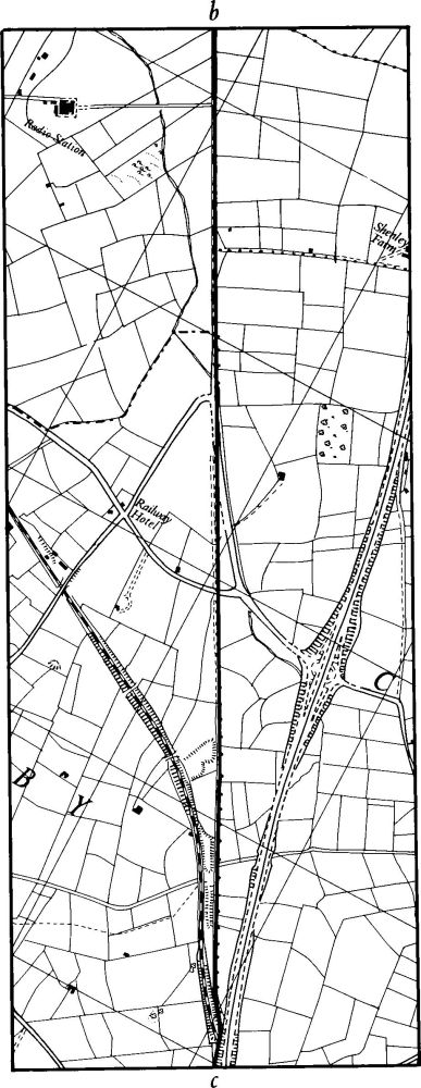
Fig. 155 Roman Road 1f, Watling Street Lilbourne – Kilsby
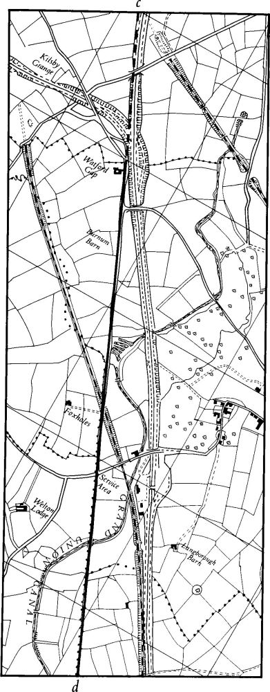
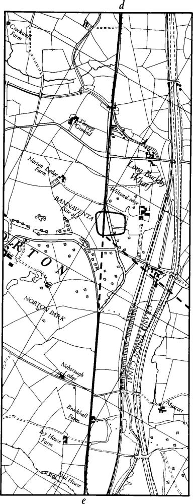
Fig. 156 Roman Road 1f, Watling Street Kilsby – Norton
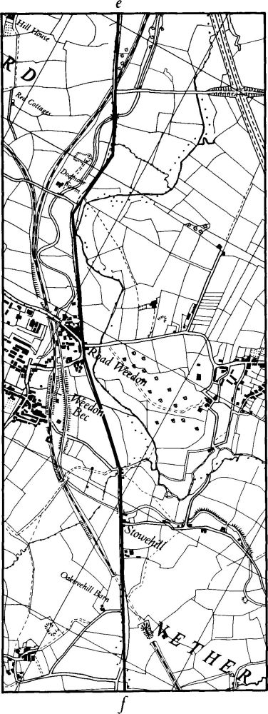
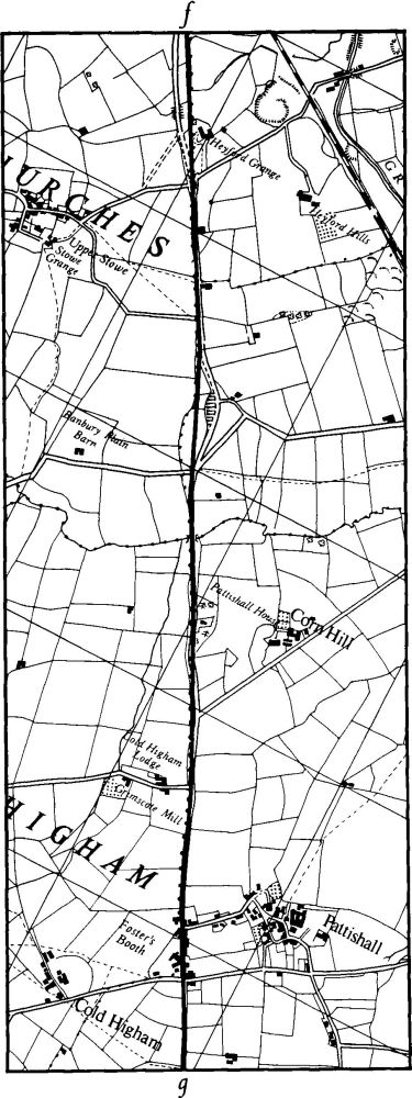
Fig. 157 Roman Road 1f, Watling Street Norton – Stowe-Nine-Churches
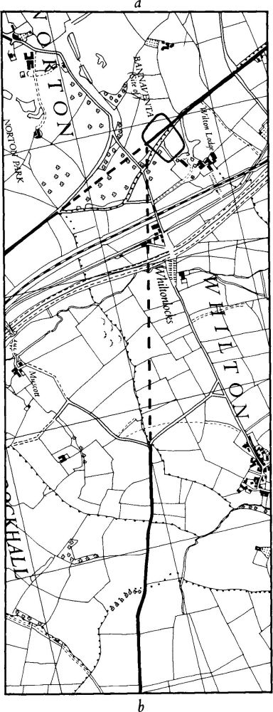
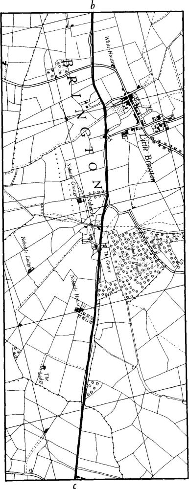
Fig. 158 Roman Road 17 Bannaventa – Brington