An Inventory of the Historical Monuments in the County of Northamptonshire, Volume 3, Archaeological Sites in North-West Northamptonshire. Originally published by Her Majesty's Stationery Office, London, 1981.
This free content was digitised by double rekeying. All rights reserved.
'Farthingstone', in An Inventory of the Historical Monuments in the County of Northamptonshire, Volume 3, Archaeological Sites in North-West Northamptonshire(London, 1981), British History Online https://www.british-history.ac.uk/rchme/northants/vol3/pp84-88 [accessed 30 April 2025].
'Farthingstone', in An Inventory of the Historical Monuments in the County of Northamptonshire, Volume 3, Archaeological Sites in North-West Northamptonshire(London, 1981), British History Online, accessed April 30, 2025, https://www.british-history.ac.uk/rchme/northants/vol3/pp84-88.
"Farthingstone". An Inventory of the Historical Monuments in the County of Northamptonshire, Volume 3, Archaeological Sites in North-West Northamptonshire. (London, 1981), British History Online. Web. 30 April 2025. https://www.british-history.ac.uk/rchme/northants/vol3/pp84-88.
In this section
29 FARTHINGSTONE
(OS 1: 10000 a SP 55 NE, b SP 55 SE, c SP 65 NW, d SP 65 SW)
The parish, covering some 725 hectares, lies across the headwaters of two small E.-flowing streams which meet on the E boundary and continue to the R. Nene. The valleys in which the two streams run have cut into Jurassic Clay but on the higher land to the S. and N., and along the central ridge between the valleys, are broad areas of Northampton Sand. The village of Farthingstone is situated on top of the ridge at about 144 m. above OD. The settlement remains (5) at the W. end of the village, suggest that it has moved E. at some period.
Fig. 67 Farndon, East (4) Settlement remains
On the higher land in the N.E. of the parish are two adjacent but very different monuments. Castle Dykes (4) is a fine and well-preserved motte with three baileys, and immediately to the S. is a now heavily mutilated enclosure (3), probably of prehistoric date. The latter, even in its present state, is a rare survival in the county.
Prehistoric and Roman
A Neolithic axe of Group VI, Great Langdale type, was found in the parish before 1904 (OS Record Cards).
c(1) Enclosures (SP 615561), S. of Heath Farm and close to the earthwork (3), on Northampton Sand at 155 m. above OD. Air photographs taken in 1970 (not seen by RCHM) are said to show cropmarks of enclosures (BNFAS, 5 (1971), 42).
c(2) Ditches (SP 615570), about 300 m. N.W. of (4), on Northampton Sand, at 156 m. above OD. Air photographs (in NMR) show the cropmarks of at least three linear ditches forming no coherent pattern.
c(3) Enclosure (SP 617563; Fig. 68), lies in the N. of the parish, immediately S. of (4), on Northampton Sand, at 160 m. above OD. It stands on level ground, though to the N. the land falls steeply into a broad valley, and commands extensive views in all directions.
The remains have now been almost entirely levelled by ploughing; the surrounding banks are only just visible, a few centimetres high. In the plough the banks are marked by concentrations of small stones and red soil and, close to the S.W. corner and along the E. bank, by areas of burnt stones. OS plans made before the drastic modern destruction indicate that it was a rectangular enclosure, probably bounded by a bank and outer ditch, with another bank beyond the ditch at least on the N. and W. sides. The present road to Upper Stowe may have destroyed the ditch and outer bank on the S. Air photographs (in NMR) show a series of cropmarks within and to the E. of the enclosure. Those to the E. include at least three possible enclosures and two ring ditches. However, the ditches within the main enclosure and immediately E. of it may mark the lines of former hedges.
The enclosure lay in woodland until the early 19th century when the area was cleared and converted to arable. While this was taking place Baker (Hist. of Northants., I (1830), 376) noted that 'the vallum at the west end is now in the process of being levelled . . . it is . . . 9 feet wide built of two outer walls of stone, each about 3 feet thick. Between these is soil, except at one point where for 3 yards earth and small burnt stones were used, with several hundredweight of iron scoria and charcoal at each end. Inside the wall . . . was a large iron spoon and the socket of a spear'. Earlier Stukeley recorded the finding of Roman coins and pavements 'at Castle Dykes' (Itinerarium Curiosum, I (1776), 114) and J. Simco wrote that 'T. Grant of Towcester has been levelling the Castle Dykes and gave me a Roman pot found in one of them' (Gents. Mag., 63 (1793), 1179). Both these writers refer to Castle Dykes, which is strictly the motte and bailey castle to the N. (4). However the remarks probably relate to this site, especially the second one which mentions levelling (VCH Northants., II (1906), 409).
In 1959 the W. side of the enclosure was sectioned in two places. An internal wall with a deep ditch beyond, as well as a substantial outer bank, was discovered. A La Tène I brooch, one sherd, possibly of Iron Age date, and large quantities of carbonized wood were found in the lower levels of the ditch (NM Records). Field-walking of the area in 1969 revealed a scatter of worked flints within and E. of the earthworks. These included two scrapers, cores and waste flakes. In addition two sherds, one of Iron Age date and the other Roman, were discovered (BNFAS, 4 (1970), 3–4; RAF VAP CPE/UK/1994, 3157–8).
Medieval and Later
c(4) Motte and baileys (SP 618567; Fig. 68), known as Castle Dykes, stands in the N. of the parish on almost level ground on Northampton Sand at 152 m. above OD. Most of the site is overgrown and difficult of access. Immediately to the E. the ground falls steeply into a deep valley and to the S. is another steep-sided tributary valley. The castle thus has a superb site with extensive views to the N., E. and S. and only on the W. and N.W. are there no natural obstacles.
The motte stands in the centre of the S. side and is circular, up to 2 m. above the natural land-surface and 4 m. above the bottom of the wide encircling ditch. The summit is edged by a low bank some 3 m.–4 m. wide and up to 0.5 m. high, apparently constructed of stone rubble. The interior of the motte has a large depression 1.5 m. deep in it, perhaps as a result of the digging there in the 18th century. On each side of the motte is a semicircular bailey, that on the W. being more regular than the one on the E., each bounded by a massive bank up to 2.5 m. high above a broad outer ditch. A gap in the E. side of the E. bailey appears to be modern. In the S.E. corner the bailey ditch bifurcates and the branches are separated by a length of bank. No reason for this can be seen. To the N. is a third, large, D-shaped bailey bounded by a bank 2.3 m. high and, except in the S., by an outer ditch up to 1.75 m. deep. The N.E. corner of the ditch has recently been destroyed by a modern track. The interior is under cultivation. There are two apparently modern entrances into it on the N.W. and E. and an original causeway links this bailey to the S.W. one across its S. ditch.
Workmen digging for building-stone on the site before 1712 are said to have discovered a 'room with a vaulted stone roof, and another room beneath', as well as 'rudely carved' stones with human figures on them (J. Morton, Nat. Hist. of Northants. (1712), 543; G. Baker, Hist. of Northants., I (1830), 375; Whellan, Dir., 416; VCH Northants., II (1906), 409; Plans and Sections, 1841, Dryden Collection, Central Library, Northampton). A medieval floor tile, said to be from Castle Dykes, is in the possession of Daventry School. Nothing is known of the history of the site but in its present form it presumably dates from the late 11th or the 12th century. However it is possible that part of the outer ramparts are of Iron Age origin, particularly those of the two semicircular baileys. Roman finds said to be from this site may in fact have come from the prehistoric enclosure to the S. (see (3) above).
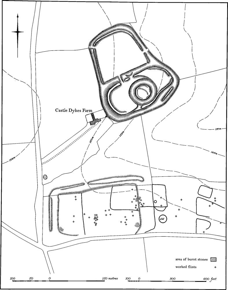
Fig. 68 Farthingstone (3) Enclosure, (4) Motte and baileys
d(5) Settlement remains (centred SP 61255495), at the W. end of the village, on gravel and Northampton Sand at about 150 m. above OD. A wide hollowed access-way, still followed by a modern footpath, runs roughly N.–S. between the Maidford and Everdon roads so forming part of a sub-rectangular system of lanes at this end of the village. On the E. side of this access-way is a line of large embanked closes or former paddocks, divided by a small hollow-way continuing the line of a farm track S. of the church. At the N. end of the group of closes are several later gravel pits.
(6) Cultivation remains. The common fields of the parish were enclosed by Act of Parliament in 1752. Though no map apparently survives, the Enclosure Award (NRO) indicates that there were three open fields in 1752 as well as an area called Rye Hill. West Field lay to the W. and N.W. of the village, Middle Field to the S. and Lower Field to the E. and N.E. Rye Hill seems to have occupied at least part of the N. of the parish. Only a small part of the ridge-and-furrow of these fields exists on the ground or can be traced on air photographs and this is mainly around the village where there are several blocks of end-on furlongs with a few, at the ends of spurs, which lie at right-angles. In the extreme N.E. of the parish there are other traces of ridge-and-furrow (RAF VAP CPE/UK/1994, 3155–9, 2160–5, 4165–8).