An Inventory of the Historical Monuments in the County of Northamptonshire, Volume 4, Archaeological Sites in South-West Northamptonshire. Originally published by Her Majesty's Stationery Office, London, 1982.
This free content was digitised by double rekeying. All rights reserved.
'Abthorpe', in An Inventory of the Historical Monuments in the County of Northamptonshire, Volume 4, Archaeological Sites in South-West Northamptonshire( London, 1982), British History Online https://www.british-history.ac.uk/rchme/northants/vol4/pp1-5 [accessed 27 July 2024].
'Abthorpe', in An Inventory of the Historical Monuments in the County of Northamptonshire, Volume 4, Archaeological Sites in South-West Northamptonshire( London, 1982), British History Online, accessed July 27, 2024, https://www.british-history.ac.uk/rchme/northants/vol4/pp1-5.
"Abthorpe". An Inventory of the Historical Monuments in the County of Northamptonshire, Volume 4, Archaeological Sites in South-West Northamptonshire. (London, 1982), , British History Online. Web. 27 July 2024. https://www.british-history.ac.uk/rchme/northants/vol4/pp1-5.
In this section
AN INVENTORY OF THE ARCHAEOLOGICAL MONUMENTS IN SOUTH-WESTERN NORTHAMPTONSHIRE
Arranged alphabetically by Parishes
1 ABTHORPE
(OS 1:10000 a SP 64 NW, b SP 64 SW, c SP 64 NE, d SP 64 SE)
The small parish occupies about 790 hectares on the S. side of the R. Tove. Its W. and E. boundaries are defined by small streams. The village is situated close to the river on a small deposit of glacial sands and gravels sloping N.W., but the greater part of the parish, between 135 m. and 145 m. above OD, is covered by Boulder Clay.
No remains of prehistoric or Roman date have been noted in the parish but there are earthworks of two medieval settlements, Foscote (3) and Charlock (5), as well as within the village of Abthorpe (1).
Medieval and Later
The handle of a medieval jug with stamped lettering on it was found in Abthorpe village in 1964 (NM; Med. Arch., 11 (1967), 233–4).
a(1) Settlement Remains (SP 647466; Fig. 18), lie immediately N. of Abthorpe village, on land sloping N., on Upper Lias Clay and glacial gravels between 100 m. and 110 m. above OD. The earthworks are typical of the abandoned closes and paddocks that surround many villages in the county and consist of shallow ditches and low scarps which mark the lines of former hedges. Some of these closes have traces of ridge-and-furrow within them. Two other features in the area are worthy of note. In the centre of the remaining earthworks ('a' on plan) an area of disturbed ground represents the remains of a farmstead which still stood in 1823 (map in NRO). A more regular pattern of closes further S.W., around Abthorpe Manor ('b' on plan), probably indicates the paddocks of the manor house. A rectangular sunken area ('c' on plan) may be the remains of part of a 17th-century garden. (RAF VAP CPE/UK/1926, 1228–9; CUAP, AWN70; air photographs in NMR)
c(2) Ponds (SP 652466; Fig. 18), lie immediately N.E. of Abthorpe village, on Upper Lias Clay at 104 m. above OD. Today there are two irregular ponds, but originally there was a single rectangular one. A dam up to 1.5 m. high still survives at the downstream end and returns along the E. side as a bank between 1.5 m. and 0.5 m. high. (RAF VAP CPE/UK/1926, 1229–30)
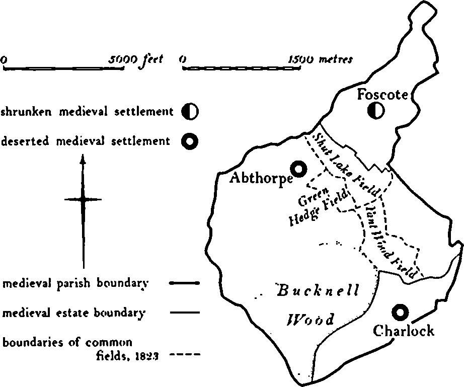
Fig. 17 Abthorpe Medieval settlements and estates
c(3) Deserted Hamlet of Foscote (SP 660473; Figs. 17, 19, 20, 21 and 22), lies in a small combe in the E. of the parish, on clay at 107 m. above OD. In medieval times the hamlet was the centre of a unit of land with its own field system entirely separate from Abthorpe. Foscote is not recorded in documents until 1200 (PN Northants., 90) but is doubtless much older. It rarely occurs in the national taxation records as it was usually included with Abthorpe or Towcester. However, in 1301 ten people paid the Lay Subsidy (PRO, E179/155/31), and in 1488 80 acres of land were enclosed and 12 people were evicted from one of the two manors there (K. J. Allison et al., The Deserted Villages of Northants. (1966), 40); in 1525 five people paid the Lay Subsidy (PRO, E179/155/130). The earliest depiction of the hamlet is a map of 1726 (NRO; Fig. 20) which shows an irregular green with five houses and two farmsteads arranged around it, and two other houses lying on the N. side of a lane to the N.E. Another farmstead, the present Hill Farm, lay to the E. On a map of 1823 associated with the enclosure of the parish (NRO; Fig. 21) the green is shown, although its S. end had by then been encroached upon by the grounds of the two houses there. One of the farmsteads still stood, but the other farm and one of the cottages both shown on the 1726 map had been abandoned, as had a lane running S.E. from the green. The lane to the N.E. and the two houses there still existed and a third building is shown in the area. Hill Farm also remained to the E. The Enclosure Map of two or three years later (NRO; Fig. 22) shows the changes effected by enclosure. The green had been reduced to a track leading N.W. to one farmstead and a house, though Hill Farm, the two houses at the S.E. end of the green and those to the N.E. all remained. The map also shows in outline the present Foscote House which was presumably built soon afterwards. By the early 19th century, therefore, the hamlet of Foscote was probably no smaller than it had been 400 years earlier and the main contraction of settlement did not occur until later. During the second half of the 19th century all the buildings at Foscote except the new Foscote House, Hill Farm and one of the cottages at the S.E. end of the old green were removed though it is possible that the two buildings N.W. of Hill Farm actually remained standing until well into this century. Most of the earthworks of this settlement are thus the result of recent desertion or are the boundaries of closes shown on the various maps.
Immediately W. of Hill Farm, in the bottom of the valley, is a group of roughly rectangular ponds set in one corner of a generally rectangular area bounded by low banks and ditches ('a' on plan). Not all the ditches are contemporary; some are relatively recent drains. The disturbed nature of the ground here suggests that it is the site of a large building or group of buildings, probably the medieval manor of Foscote. The village earthworks are in poor condition. The outlines of the original green ('b' on plan) can be identified from the existing hedges or by low banks and scarps, but the sites of the buildings on the 1726 and 1823 maps are now only disturbed ground. No trace exists of the lane which ran N.E. from the green and again only disturbed ground marks the sites of the cottages which stood there. To the S.W. ('c' on plan), a ditch represents the line of a hedge shown on the 1726 map but which had been removed by 1823. (RAF VAP CPE/UK/1926, 1229–31; CUAP, AW061; air photographs in NMR)
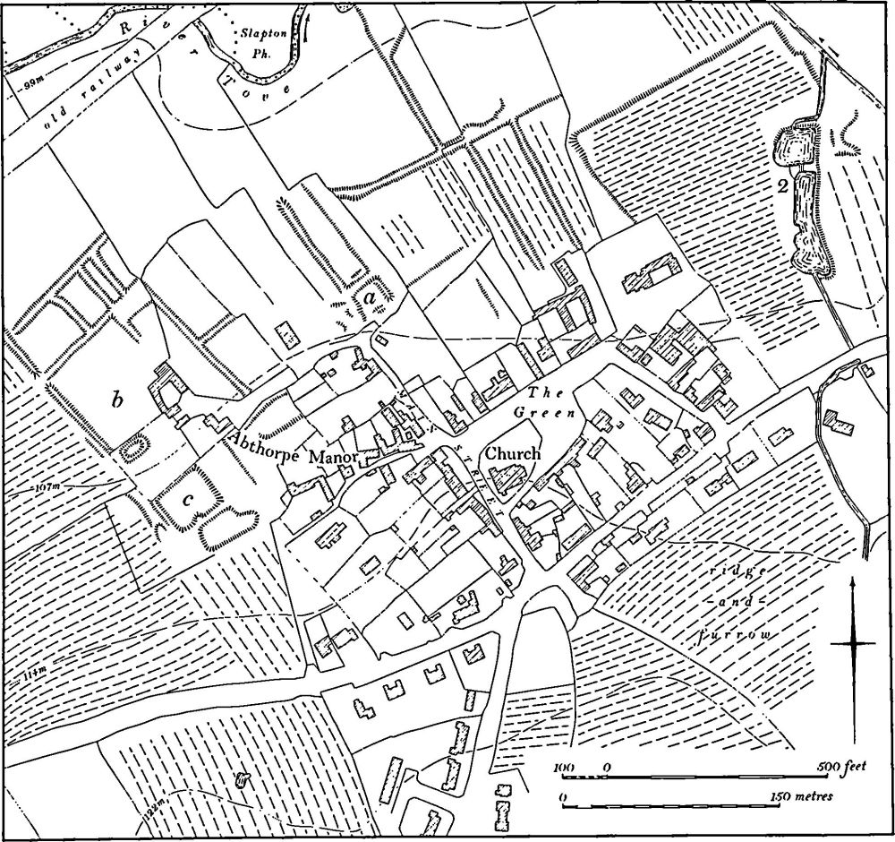
Fig. 18 Abthorpe (1) Settlement remains (2) Ponds
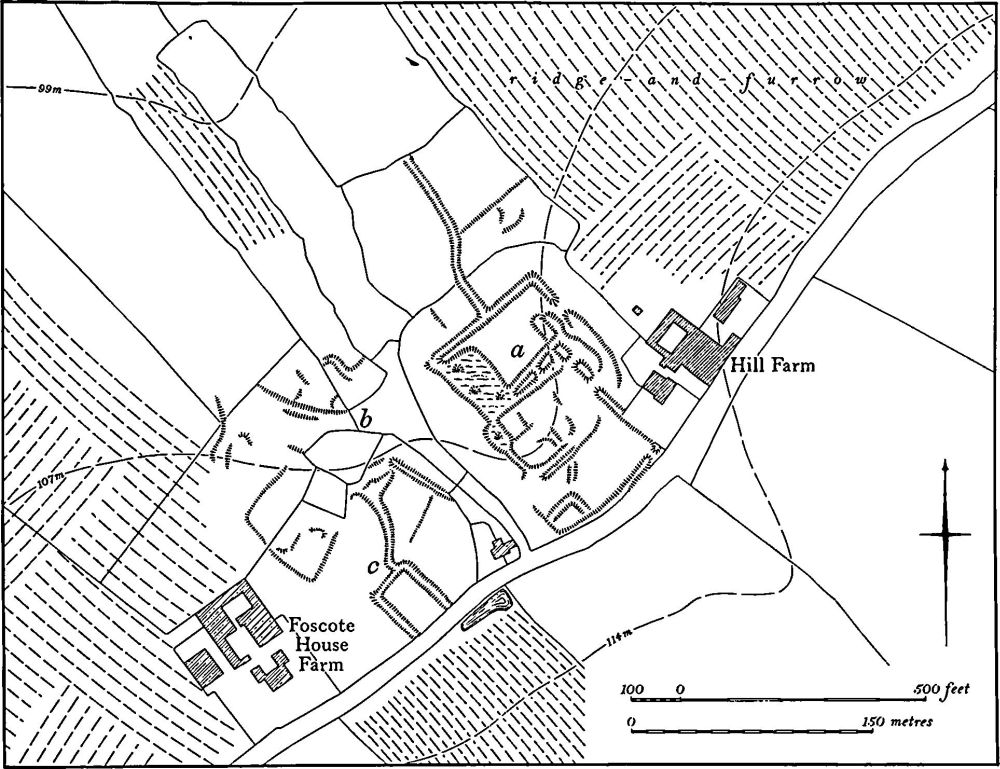
Fig. 19 Abthorpe (3) Deserted hamlet of Foscote
c(4) Mound (SP 65674684), lies S.W. of Foscote, on the top of a low hill, on Boulder Clay at 122 m. above OD. The mound is circular, 15 m. in diam. and only 0.3 m. high, with a shallow depression in the centre, and is surrounded by a very slight ditch 3 m. wide. Beyond the ditch are traces of an outer bank. The adjacent ridge-and-furrow appears to avoid the mound. It is not shown on any known map but in 1726 (map in NRO) the field in which it lies was called Moor Close. On a map of 1823 (NRO) the field, which had by then been enlarged to the N.E., was called the Moat and Fullers Close. The mound is likely to be the site of a windmill though it has been suggested that it may have been a cock-pit (OS Record Cards). (RAF VAP CPE/UK/1926, 1229–30; air photographs in NMR)
d(5) Deserted Hamlet of Charlock (SP 662447; Figs. 17 and 23), lies in the S. of the parish, S. of Charlock Farm and E. of the site of a former farm known as Old Charlock, on Boulder Clay at 122 m. above OD. Nothing is known of the history of the site. It is not recorded by name until 1250 (PN Northants., 90) though it is probably much older. It is presumably included with Abthorpe in the national taxation records, though it was the centre of a separate land unit occupying the S. of the modern parish and appears to have had its own field system (6). The principal interest of the remains is that they appear to have been fitted into the end of a pre-existing furlong of ridge-and-furrow and thus must post-date the field system of the area.
The remains consist of a roughly rectangular area bounded by shallow ditches on the S.E. Two ditches on the N.E. appear to continue the furrows of the furlong to the S.E., as does another ditch crossing the interior. Within the enclosed area are a number of small paddocks, bounded by shallow ditches or low scarps. In the W. corner is a low circular mound and on the N.W. side are two adjacent depressions, perhaps once ponds. Traces of a hollow-way are visible on the N.E. (RAF VAP CPE/UK/1926, 3230–1; air photographs in NMR)
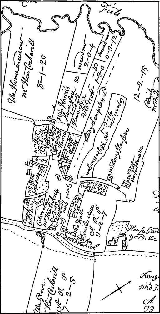
Fig. 20 Abthorpe (3) Deserted hamlet of Foscote. Part of a plan of 1726 (NRO)
(6) Cultivation Remains (Fig. 17). The surviving parts of the common fields of Abthorpe, some 130 hectares, were enclosed by an Act of Parliament of 1823 (NRO, Enclosure Map; G. Baker, Hist. of Northams., II (1836–41), 271). This area was divided into three fields, Shutlake Field to the E. and S.E. of the village, Green Hedge Field to the S. and Yant Wood Field further S.E.
Ridge-and-furrow of these fields exists on the ground or can be traced on air photographs only in the former Shutlake and Green Hedge Fields, where it agrees exactly with the furlongs shown on the Enclosure Map. It is arranged in end-on and interlocked furlongs of reversed-S form. Ridgc-and-furrow also survives in the area of Abthorpe which had been enclosed before 1823, and in areas which were already enclosed in 1726, notably along the edges of Bucknell Wood (SP 655458) and in the W. of the parish (SP 640456 and 646456).
The date of the enclosure of the common fields of the now deserted hamlet of Foscote (3) is unknown, though 80 acres of land were enclosed in 1488 (K. J. Allison et al., The Deserted Villages of Northants. (1966), 40). Ridge-and-furrow exists on the ground or can be traced on air photographs over much of the land attributable to Foscote, particularly in pasture around the site of the village. It is arranged in normal end-on and interlocked furlongs.
The date of the enclosure of the common fields of the deserted hamlet of Charlock (5) is also unknown but was before 1726 (map in NRO), and was probably much earlier than that. A little ridge-and-furrow remains or can be traced on air photographs in the S. of the parish around the site of the hamlet. (RAF VAP CPE/UK/1926, 1227–31, 3228–30)
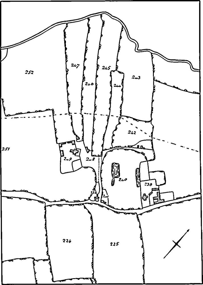
Fig. 21 Abthorpe (3) Deserted hamlet of Foscote. Part of a plan of 1823 (NRO)
Fig. 22 Abthorpe (3) Deserted hamlet of Foscote. Part of the Enclosure Map (NRO)