An Inventory of the Historical Monuments in the County of Northamptonshire, Volume 4, Archaeological Sites in South-West Northamptonshire. Originally published by Her Majesty's Stationery Office, London, 1982.
This free content was digitised by double rekeying. All rights reserved.
'Potterspury', in An Inventory of the Historical Monuments in the County of Northamptonshire, Volume 4, Archaeological Sites in South-West Northamptonshire(London, 1982), British History Online https://www.british-history.ac.uk/rchme/northants/vol4/pp118-121 [accessed 30 April 2025].
'Potterspury', in An Inventory of the Historical Monuments in the County of Northamptonshire, Volume 4, Archaeological Sites in South-West Northamptonshire(London, 1982), British History Online, accessed April 30, 2025, https://www.british-history.ac.uk/rchme/northants/vol4/pp118-121.
"Potterspury". An Inventory of the Historical Monuments in the County of Northamptonshire, Volume 4, Archaeological Sites in South-West Northamptonshire. (London, 1982), British History Online. Web. 30 April 2025. https://www.british-history.ac.uk/rchme/northants/vol4/pp118-121.
In this section
47 POTTERSPURY
(OS 1:10000 a SP 74 SE, b SP 74 SW)
The modern parish covers about 780 hectares. It is long and narrow and slopes generally S.E., drained by small streams flowing towards the Great Ouse. It is almost entirely covered by Boulder Clay except around the village and in the S.E. where limestones are exposed along the valley sides.
Until 19th-century boundary changes Potterspury included the whole of the parish of Yardley Gobion, but only extended a little to the S.W. of Watling Street. It now includes what was once a detached part of Cosgrove parish, as well as the whole of Wakefield Lawn and its surrounding area. The latter was once partly common land in Whittlewood Forest though within it lay the settlement of Wakefield, first recorded in Domesday Book (VCH Northants., I (1902), 329, 374). The site of the deserted village of Furtho (9) and part of its former lands occupy the S.E. of Potterspury but the rest of Furtho parish is now incorporated within Cosgrove and Old Stratford.
This parish contains a number of prehistoric and Roman sites but is most renowned for its medieval and post-medieval pottery kilns.
Prehistoric and Roman
A large axe of white flint was found in the parish before 1903 (NM) and other flint and stone implements have been collected in the N.W. of the area. These include part of a Bronze Age perforated stone battle-axe of Group XIV (Wolverton and District Arch. Soc. Newsletter, 6 (1961), 2).
a(1) Ring Ditches (SP 769423), in the S.E. of the parish close to Watling Street, on the N. side of a small E.-flowing stream, on limestone at 75 m. above OD. Air photographs (NCAU) show two ring ditches 25 m. in diam. and 35 m. apart.
ab(2) Enclosure and Ditches (centred SP 750434), W. of Sunnyside Farm and adjoining Watling Street, on limestone at 91 m. above OD. Air photographs (in NMR) show what appear to be two sides of a sub-rectangular enclosure with some linear ditches to the S.
b(3) Iron Age Settlement (SP 729435), immediately N. of the Kennels, on Boulder Clay at 120 m. above OD. Sherds of early and middle Iron Age pottery, including some of Trent Basin type, were ploughed up in 1959 (Wolverton and District Arch. Soc. Newsletter, 6 (1961), 2; BNFAS, 1 (1966), 5).
a(4) Iron Age and Roman Settlement (SP 763433), in the E. of the village, on limestone at 80 m. above OD. Sherds of late Iron Age and 1st-century Roman pottery were revealed during building work on this site (BNFAS, 1 (1966), 5; Wolverton and District Arch. Soc. Newsletter, 10 (1966), 40).
b(5) Roman Villa (SP 736429), beneath the artificial lake in front of Wakefield Lodge, on Boulder Clay at 103 m. above OD. Much Roman material has been dredged from the lake, including dressed limestone, brick, roof and flue tiles, tesserae, window glass and pottery (Wolverton and District Arch. Soc. Newsletter, 6 (1961), 3; BNFAS, 1 (1966), 12; see also Deanshanger, Prehistoric and Roman Introduction).
b(6) Roman Building (SP 747425), E. of Redmoor Copse, on Boulder Clay at 105 m. above OD. Ploughing has revealed disturbed floors and walls, nails, 3rd and 4th-century pottery, samian ware and mortarium sherds (BNFAS, 1 (1966), 12).
a(7) Roman Settlement (SP 761420), in the S. of the parish, on limestone at 85 m. above OD. Roman tile and pottery of 1st and 2nd-century types have been found. A pronounced agger, said to be a possible Roman road, runs E. from this site towards Watling Street (BNFAS, 1 (1966), 12; 3 (1969), 1). For medieval pottery from this site, see (15).
For Roman Road ie, Watling Street, see Appendix.
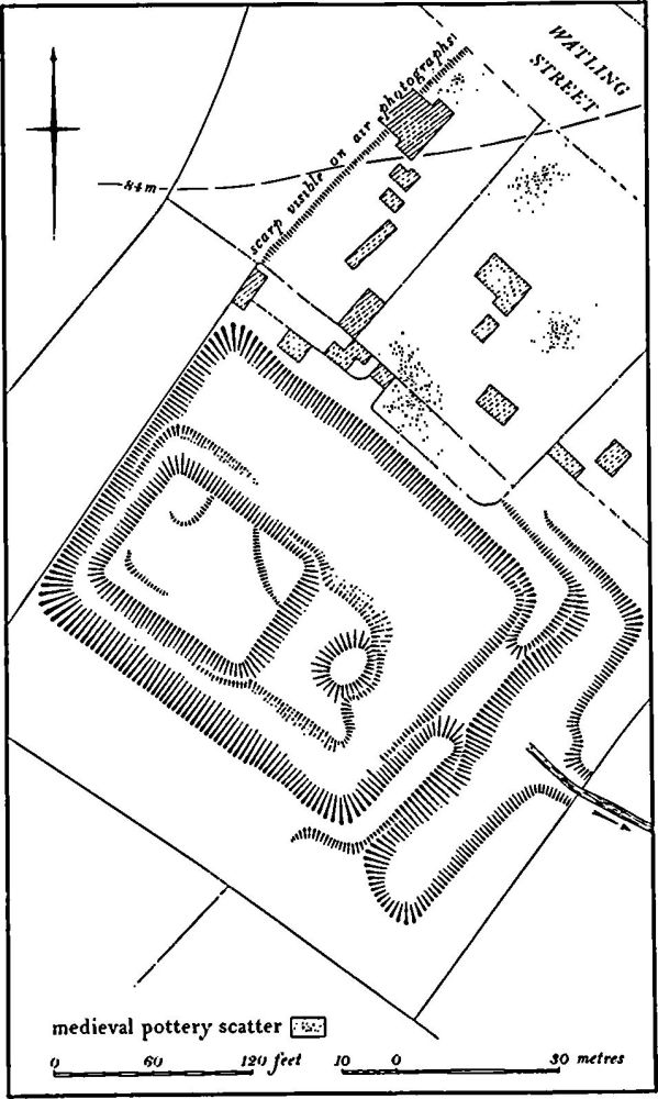
Fig. 95 Potterspury (8) Moat
Medieval and Later
a(8) Moat (SP 764423; Fig. 95), lies S.E. of the village, on the S.W. side of Watling Street, on beds of the Estuarine Series, at 83 m. above OD. The site is situated on a spring line on the N. side of a shallow valley draining E. Nothing is known of its history beyond the fact that the field in which it lies was already an isolated old enclosure in 1776, lying on the E. side of an open area known as Brown's Wood Green (map in NRO).
The site has been misinterpreted in the past, notably by the OS who saw it as a large rectangular depression with an almost square island in the W. corner and a small circular one to the S.E. This situation is clearly the result of relatively recent destruction. The small island stands on a rectangular platform slightly above the level of the bottom of the surrounding ponds. It appears that there was originally one large island occupying the S.W. of the site and that the small island is the only fragment of the E. part that has survived to its original height.
This large island was asymmetrically placed, partly perhaps to provide a fishpond on the N.E. side, but also because of the natural topography of the small valley in which the site lies. The wide part of the pond occupies the lowest part of the valley. The water was retained in the pond and around the island by a massive dam on the S.E. side, up to 2 m. high. Below the dam and parallel with it is a long narrow pond, possibly once two ponds, which turns N.W. at its N.E. end, parallel with the N. side of the moat. The site is in poor condition, having been used as a nursery garden, but large quantities of medieval sherds have been revealed, particularly from the destroyed S.E. part of the island. Medieval pottery, mainly of Potterspury type, has also been noted within the gardens of the bungalows to the N.E. of the moat, suggesting that the medieval settlement extended beyond the surviving earthworks. This is confirmed by air photographs taken before the northernmost bungalow was constructed, showing a low scarp, perhaps the boundary of a former close, extending from the moat to Watling Street. (RAF VAP CPE/UK/1926, 2243–4, 4224–5)
a(9) Deserted Medieval Village of Furtho and Garden Remains (SP 773431; Fig. 96), lie against the modern boundary between Potterspury and Cosgrove, on the S. side of a small valley, on Boulder Clay at 75 m. above OD. The medieval parish of Furtho included land to the N. and S. now in Cosgrove and Old Stratford (Fig. 16). The village is first mentioned in Domesday Book when it was divided into three small holdings with a total recorded population of 15 (VCH Northants., I (1902), 15). However, one of these manors may have been the deserted hamlet which lies to the S. in the part of Old Stratford formerly in Furtho parish (Old Stratford (9)). Furtho is named in the Nomina Villarum of 1316. No indication of its later medieval population is available as it was always taxed with Cosgrove, except in 1525 when three people paid the Lay Subsidy (PRO, E179/155/130). In 1547 200 sheep were maintained on the manor. Around 1600 Edward Furtho, a member of the family who had held the manor since the 13th century, enclosed the parish, de-populated the village, diverted the main through road and rebuilt the church. The existing building is said to be of about 1620 (N. Pevsner, Northamptonshire (1961), 212; K. J. Allison et al., The Deserted Villages of Northants. (1966), 40).
By 1720 'only one house, with the church', survived although 'the remains of a former village' were still to be seen (J. Bridges, Hist. of Northants., I (1791), 296). The house is shown standing to the S.W. of the church, together with the remains of its formal garden, on a map of 1835 (NRO; see also Tithe Map, 1850). It was demolished in the late 19th century and replaced by the present Manor Farm to the S. A circular stone dovecote, said to be of the 15th century, is shown immediately S. of the original house and still remains.
Apart from one of the medieval fishponds, now dry, and part of the post-medieval garden, no earthworks have survived the extensive modern agricultural improvements. However, from air photographs taken before destruction (RAF VAP CPE/UK/1926, 2245–6; CUAP, XT35), more recent air photographs (in NMR) and the modern OS 1:2500 plan (SP 7743) it is possible to reconstruct a plan of the earthworks as they existed in 1947 (Fig. 96). The main feature of the site was a broad hollow-way ('a'-'b' on plan), presumably the main through road, which ran approximately E.-W. parallel with the stream. At its W. end its line is continued by a broad curving headland which once joined Furtho Lane in Potterspury village but the E. extension of the road cannot be traced. The part of this hollow-way immediately N.E. of the church was between 9 m. and 18 m. wide. Immediately to the S. of this, E. of the church ('c' on plan), there was a series of rectangular paddocks bounded by banks and ditches with, to the S. again, a large circular mound 20 m. in diam. and 1 m. high which still partly survives. To the N. of the hollow-way ('d' on plan) were two long rectangular fishponds separated by a low bank and bounded on the E. by a broad dam. Only the northern pond now survives with the dam up to 2 m. high. Along the valley side to the W. of the church and N.W. of Manor Farm there were other more indeterminate earthworks ('e').
The post-medieval garden ('f' on plan) lay immediately N. of the church and N.E. of the site of the old manor house. As its remains lie across the alignment of the medieval hollow-way, the garden must have been constructed after the road was put out of use. The 1835 map shows a long rectangular area divided into rectangular flower beds with what appears to be a shrubbery to the N. between the flower beds and a large pond. This pond, together with the scarp 1 m. high which apparently marks the division between the flower beds and the shrubbery, survives though in poor condition.
a(10) Settlement Remains (SP 752434 and 754431), formerly part of Potterspury, lie on the S.W. side of Watling Street, on limestone between 85 m. and 90 m. above OD. A map of Potterspury in 1728 (NRO) shows at least six houses situated on the wide verge of Watling Street. These were presumably late encroachments on the waste. By 1776 (NRO, Enclosure Map) some of the buildings had been removed and most had disappeared by the mid 19th century (1st ed. 1 in. map of 1834). Their sites are still preserved as sub-rectangular depressions cut back into the rising ground.
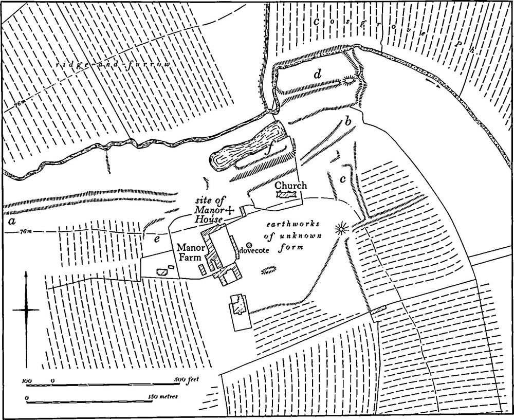
Fig. 96 Potterspury (9) Deserted village of Furtho and garden remains
(11)–(14) Pottery Kilns. Several medieval and postmedieval pottery kilns have been discovered in and around the village. The general background to the pottery industry in Potterspury has already been published (Post-Med. Arch., 2 (1968), 55–81). The specific kilns are listed below.
a(11) Medieval Pottery Kiln (SP 760431), in the garden of a former farm-house in the village, on limestone at 92 m. above OD. A late 14th-century, single-flue, updraught kiln with a circular oven and a roughly rectangular stoke-hole was excavated in 1970. It produced jugs and bowls of buff fabric with olive-green glaze. (Med. Arch., 15 (1975), 177)
a(12) Medieval Pottery Kiln (SP 762433), close to the above and in a similar situation, near the vicarage. Trial excavations have been carried out on a kiln which apparently produced several different types of late medieval pottery (Med. Arch., 9 (1965), 217).
a(13) Medieval Pottery Kiln (SP 76084314), N. of High Street, on limestone. A small oval single-flue kiln excavated in 1949 contained wasters of many different vessels as well as roof tiles dating from the 14th or 15th century (Arch. Newsletter, 2 (1949–50), 156–7).
a(14) 17th-century Pottery Kilns (SP 76164317), in the garden of a new house constructed in the grounds of the vicarage. Excavation in 1965 revealed two kilns, a drying hut and perhaps a potter's workshop. The site has been fully published elsewhere. (BNFAS, 4 (1970), 24; 7 (1972), 49–51; Wolverton and District Arch. Soc. Newsletter, 10 (1966), 10; Post-Med. Arch., 2 (1968), 55–81)
a(15) Medieval Pottery (SP 761421), in the same area as the Roman site (7). Some medieval sherds have been found close to the stream (BNFAS, 1 (1966), 12).
a(16) Stone-Quarries (?) (SP 761433), lie on the N. side of the valley immediately N.W. of the church, on rocks of the Upper Estuarine Series, at 90 m. above OD. An expanse of what appears to be ancient stone-quarrying covers the side of the hill. At the E. end quarrying has cut through pre-existing ridge-and-furrow. A few sherds of medieval pottery have been found on the quarried areas. The proximity of the medieval kilns may be of significance in the interpretation of these earthworks. The area lay within the old enclosure around the village in 1776 (NRO, Enclosure Map). (RAF VAP CPE/UK/1926, 2244–5; air photographs in NMR)
(17) Cultivation Remains. The common fields of Potterspury and of Yardley Gobion were apparently all worked as one, and were enclosed by an Act of Parliament of 1775 (NRO, Enclosure Map, 1776). The Act also enclosed an area called Fersen Field, which was a detached part of Cosgrove parish (G. Baker, Hist. of Northants., II (1836–41), 128). No details of these fields are known, beyond their general area. The Enclosure Map, as well as an earlier map of 1728 (NRO), shows that the common fields lay only to the S.E., N. and E. of the village. Ridge-and-furrow of these fields exists on the ground or can be traced from air photographs in very few places. There is a group of interlocked furlongs S.E. of the village (SP 768428) and isolated areas elsewhere (e.g. SP 767432, 770438 and 755438). Immediately N. of the village (SP 760435) is an extensive area of ridge-and-furrow preserved in permanent grassland along the valley sides. Part of this lay in the former open fields, but the rest was already in old enclosures in 1776.
Ridge-and-furrow also survives in other parts of Potterspury parish which apparently were never arable land in the common fields. In the extreme S. of the parish (SP 765421), on either side of a N.E.-flowing stream, are four rectangular interlocked furlongs which lay at the S. end of an area known as Brown's Wood Green. This was apparently common pasture land until after 1776 when it was enclosed into its present fields. This ridge-and-furrow is probably medieval in date and may be associated with the moat (8) which lies immediately to the N. Another block of ridge-and-furrow (SP 757429) lies immediately S.W. of the village and of Watling Street, within the land which was once a detached part of Cosgrove parish. This had been enclosed before 1776, apparently directly from the waste woodland. The ridge-and-furrow here fits within the modern field boundaries.
Other ridge-and-furrow, again lying within existing fields, can be seen N.W. of the village (SP 755435) on land which was also old enclosures in 1728, but which is said once to have been common grazing land shared by Potterspury and Yardley Gobion. In the W. of the parish, within Wakefield Lawn (SP 735434), further blocks of ridge-and-furrow are traceable. These may be the remains of the arable land of the former settlement of Wakefield, though it is more likely that it represents either contemporary or later ploughing of the ancient deer lawn.
The common fields of the deserted village of Furtho (9) were enclosed in about 1600 by Edward Furtho when the village itself was depopulated. Ridge-and-furrow of these fields can be traced only on air photographs around and to the S. of the site of the village where it is arranged in large rectangular furlongs set at right angles to each other (centred SP 773425). Other traces of ridge-and-furrow once part of the Furtho common fields are visible to the N.E., around Badger's Farm (now in Cosgrove parish, SP 777440) and S.E. of Knotwood Farm (now in Old Stratford parish, SP775417). (RAF VAP CPE/UK/1926, 2240–6, 5238–45; F21 58/ RAF/517, 0026–31)
For Potterspury deer park, see Yardley Gobion (8).