An Inventory of the Historical Monuments in the County of Northamptonshire, Volume 4, Archaeological Sites in South-West Northamptonshire. Originally published by Her Majesty's Stationery Office, London, 1982.
This free content was digitised by double rekeying. All rights reserved.
'Quinton', in An Inventory of the Historical Monuments in the County of Northamptonshire, Volume 4, Archaeological Sites in South-West Northamptonshire(London, 1982), British History Online https://www.british-history.ac.uk/rchme/northants/vol4/pp121-124 [accessed 30 April 2025].
'Quinton', in An Inventory of the Historical Monuments in the County of Northamptonshire, Volume 4, Archaeological Sites in South-West Northamptonshire(London, 1982), British History Online, accessed April 30, 2025, https://www.british-history.ac.uk/rchme/northants/vol4/pp121-124.
"Quinton". An Inventory of the Historical Monuments in the County of Northamptonshire, Volume 4, Archaeological Sites in South-West Northamptonshire. (London, 1982), British History Online. Web. 30 April 2025. https://www.british-history.ac.uk/rchme/northants/vol4/pp121-124.
In this section
48 QUINTON
(OS 1:10000 a SP 75 SE, b SP 75 NE)
The parish is long and narrow and of irregular shape, covering some 350 hectares. It slopes generally N. towards a W.-flowing tributary of the R. Nene on the N. boundary. The higher ground around and S. of the village, above 100 m. above OD, is all covered by Boulder Clay. Limestones and Northampton Sand are exposed in narrow bands immediately W., N. and E. of the village and there are small areas of Upper Lias Clay as well as glacial deposits on the lower ground in the N. Two important sites have been excavated over recent years, an Iron Age and Roman settlement (5) and a medieval moated site (6), both on the S. side of the village. The latter is an element in the interesting medieval settlement pattern of the parish (6–9).
Prehistoric and Roman
b(1) Enclosures (SP 766556), in the extreme N.W. of the parish, on alluvium at 70 m. above OD. Air photographs (not seen by RCHM) are said to show several sub-rectangular enclosures (BNFAS, 5 (1971), 40).
b(2) Enclosures and Ring Ditch (SP 770556), 400 m. E. of (1). Air photographs (not seen by RCHM) are said to show cropmarks of a ring ditch and two sub-rectangular enclosures (BNFAS, 5 (1971), 40).
b(3) Enclosure and Ditches (SP 771553), 450 m. S.S.E. of (2), on glacial sand and gravel at 82 m. above OD. Air photographs (CUAP, AOK36) show cropmarks of a rectangular enclosure only 0.25 hectares in area with an entrance in the E. side and a large pit in the N.W. corner. Traces of ditches are faintly visible to the E.
a(4) Ring Ditches (?) (SP 771548 and 772547), N.W. of the village, on Northampton Sand and limestone, at 88 m. above OD. Air photographs (not seen by RCHM) are said to show cropmarks of two ring ditches. A later authority has suggested that one of these is the site of a windmill, but this is doubtful (BNFAS, 4 (1970), 32; 7 (1972), 60).
a(5) Neolithic (?), Iron Age and Roman Settlement (centred SP 775535), S. of the village, on Boulder Clay at 105 m. above OD. The site lies in Great Hold Field, close to a medieval moated site (6); both sites have been excavated in recent years. The prehistoric and Roman settlement was completely unrecorded and lay beneath ridge-and-furrow until modern ploughing revealed its existence. The excavations have been published fully elsewhere and only a summary is given here.
Excavation revealed evidence of possible late Neolithic occupation, including over 100 worked flints as well as leaf-shaped and barbed-and-tanged arrowheads. The main features, however, were of late Iron Age and Roman date. The excavator distinguished three phases at the N. end of the site. In phase I, the most important feature was the ditch of a circular house 13 m. in diam. with two entrances. There were also numerous pits, ditches and depressions some of which may have been ovens or kilns, perhaps for simple pottery manufacture, but otherwise of unknown function. A cremation burial was discovered as well as late Belgie and Roman pottery including samian, spindle whorls and three brooches. This phase probably lasted from the early 1st century AD to the last quarter of that century. In phase II a stone building was constructed, overlying the circular structure of Phase I. Foundations of a rectangular stone building, 9.43 m. by 7.72 m. overall, divided into one large and two small rooms, were investigated. Hearths or ovens and pits were identified within the building, and the post-holes of a porch at the S. end. Finds included much Roman pottery, including colourcoated and samian wares, glass, building material and four coins. The latter were all of the mid 4th century, but the construction and main occupation of the building was thought to have been from the late 1st to the late 2nd century. In phase III no further construction had taken place but there was evidence from coins that the perhaps decaying building was still in use in the 3rd and 4th centuries.
Further excavations a little to the S. revealed a sequence of ditches from the mid 1st century AD culminating in a 3rd-century circular building of unusual type. The foundations of a stone building, similar to that to the N. and on the same alignment, were also uncovered. Finds included three brooches, one of the 1st century and two of the 2nd century, as well as parts of a silvered bronze mirror, a bronze needle, a paste intaglio of Bacchus, a bronze manicure set and a ring. Iron knives, iron nails suggesting shoe-making, iron slag, Roman coins and Iron Age and Roman pottery were also present. (BNFAS, 5 (1971), 25; 7 (1972), 30–31; Northants. Archaeol., 8 (1973), 5, 15–16; 9 (1974), 95–6; 10 (1975), 162; 11 (1976), 193; 12 (1977), 215; 14 (1979), 103–4; CBA Group 9, Newsletter, 5 (1975), 17; 6 (1976), 21; 7 (1977), 13; Britannia, 3 (1972), 324; 6 (1975), 253; 7 (1976), 334–5: J. Northants. Mus. and Art Gall., 11 (1974), 1–59)
Medieval and Later
a(6) Moat (SP 776541; Fig. 97; Plate 7), lay on the S. side of the village, on Boulder Clay, at 100 m. above OD, to the N. of a large Iron Age and Roman site (5). Excavations have been carried out at both sites since 1969: only a summary is given here. Immediately before excavation the moat consisted of a shallow ditch completely surrounding an island, but this was only part of an area of earthworks recorded on air photographs taken before destruction (Plate 7; RAF VAP CPE/UK/1926, 3021–3). These show that, in addition to the main moat, there was a smaller ditched enclosure to the N.W. and a large pond to the S.E. To the S. and S.W. were small closes or paddocks, bounded by low banks or shallow ditches, all apparently overlaid by later ridge-and-furrow. The site was a fine example of a manorial complex and was presumably the site of the main manor of Quinton which is recorded from 1086 onwards (VCH Northants., IV (1937). 282–3).
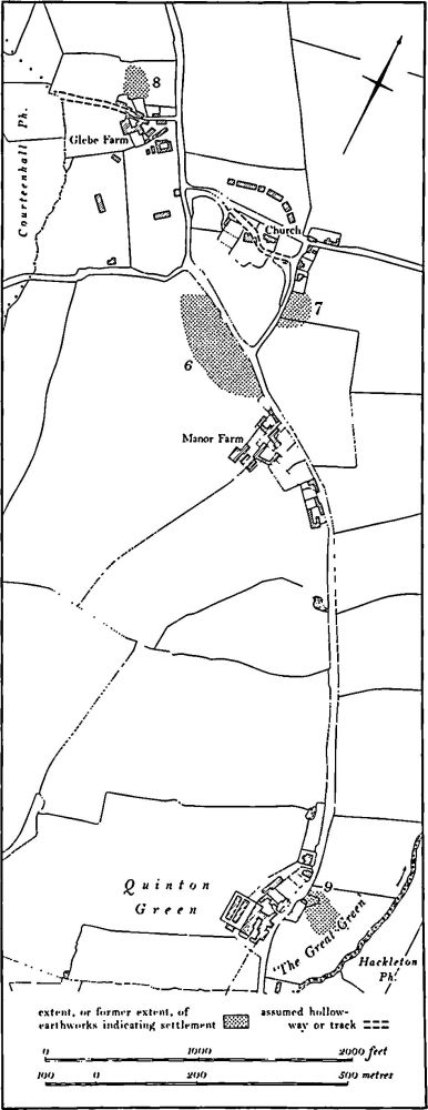
Fig. 97 Quinton (6) Moat, (7–9) Settlements remains
The excavations, confined to the main moat, showed that the surrounding ditch was no more than 1 m. deep and had been deliberately filled in after the 17th century. The earliest phase of building within the moat was represented by stake- and post-holes of a timber structure earlier than the 12th century. The first stone building was probably of the mid 12th century and various reconstructions took place up to the late 14th century. It was made of good-quality limestone, roofed with stone slate and green-glazed ridge tiles. Foundations of a hall and solar and of kitchen ranges were exposed. The former had a guardrobe tower on its W. side. The kitchens contained kilns, ovens and hearths, including a possible pottery kiln, a corn-drying oven and a large circular kiln with the appearance of a lime-kiln although there was no definite evidence for any of these functions. Finds included sherds of 12th to 14th-century date, two complete jugs thought to be from Brill (Buckinghamshire) and Potterspury, a Lyveden face-mask from a jug, an annular brooch, bronze pins, two seals, an iron key, nails, glass, lead, a silver penny of David II of Scotland, a 15th-century token, a pottery spindle-whorl and an unusual sculpture of a monkey with a drum. (BNFAS, 4 (1970), 21; 5 (1971), 34; 7 (1972), 51–2; Northants. Archaeol., 8 (1973), 23; 9 (1974), 109; 10 (1975), 169; 11 (1976), 200; CBA Group 9, Newsletter, 4 (1974), 19: 5 (1975), 21: 6 (1976), 21; Med. Arch, 15 (1971), 164; 16 (1972), 195)
(7)–(9) Settlement Remains (Fig. 97), formerly part of Quinton village. The remains described below though scant are historically important because, together with the standing buildings and cartographic evidence, they indicate that the village was once made up of a number of distinct parts. One part lay around the medieval church (7) but probably never consisted of more than a few houses until the present century. To the N.W., around Glebe Farm (8), there seems to have been another small group of buildings. The moat (6) to the S., with the existing Manor Farm and some other houses which have left no visible trace (NRO, map of 1723), formed another distinct settlement. Further S. again lay the small hamlet of Quinton Green (9).
a(7) Settlement Remains and Hollow-Way (SP 776543; Fig. 97), lie immediately W., S. and S.E. of Quinton church, at 97 m. above OD. The present drive from the Preston Deanery road to the Old Rectory occupies a broad hollow-way 13 m. wide and up to 1.5 m. deep. It continues as a hollow-way between the Old Rectory and the church, then turns E. to pass along the S. side of the churchyard and runs into School Lane. In 1723 (map in NRO) this was the main road past the church and the section of the present Preston Deanery road to the N. of the church did not exist. The modern road was constructed and the old lane abandoned at some time between 1723 and 1815 (map in NRO). On the E. side of School Lane, on the site of and to the S. of the School House, there were in both 1815 and 1723 three closes, all devoid of buildings. The area has now been built over, but air photographs taken in 1947 (RAF VAP CPE/UK/1926, 3021–2) show parts of the boundary banks, already damaged. These closes were probably the sites of houses abandoned before 1723. (Air photographs in NMR)
a(8) Settlement Remains (SP 772544; Fig. 97), lie immediately N.W. of Glebe Farm at the N.W. end of the village, on limestone at 94 m. above OD. Only Glebe Farm and the modern Glebe Cottage stand today but until very recently there were derelict cottages alongside a narrow E.-W. lane to the N. of the farm. The farm, three houses on the N. side of the lane and another isolated building to the N.W. are shown on a map of 1723 (NRO). The lane ran further W. to the bottom of a valley. Apart from the rubble of the recently demolished buildings little remains on the ground. The field N. of the farm has old quarry pits over its E. part and ridge-and-furrow on its W. half. Some low banks are the sites of hedges in existence in 1723. The site of the isolated building is marked by a rectangular sunken platform and the extension of the lane to the E. is preserved as a damaged hollow-way of which only part of the S. side survives. (Air photographs in NMR)
a(9) Settlement Remains (SP 783531; Fig. 97), formerly part of the hamlet known as Quinton Green, lies in the S. of the parish, on limestone and Boulder Clay at 107 m. above OD. Today the hamlet consists of one farm and a small group of cottages on the W. side of the road. However, in 1815 (NRO, Enclosure Map) these buildings lay on one side of an open triangular area known as The Great Green. On the N.E. side of this green were other houses which have now disappeared. The greater part of the area of the houses in 1815 is occupied by modern farm buildings, but further S.E. pottery of 14th to 18th-century date, together with stone and brick rubble, has been found in the modern arable land. This indicates that there may have been a larger hamlet in the area. Nothing is known of its history, but it may have been a relatively late settlement on the edge of Salcey Forest, which in medieval time extended into the parish. The fields immediately S.E. of the site (SP 788526) were known as East Assarts in 1815.
a(10) Site of Windmill (SP 76815455), lies in the E. of the parish, on the top of a N.E.-projecting spur of Upper Lias Clay at 94 m. above OD. Air photographs taken in 1947 (RAF VAP CPE/UK/1926, 5021–3) show a well-marked mound, some 15 m. in diam., with a surrounding ditch. By 1966 the mound had been completely destroyed and only a circular cropmark 20 m. across shows on air photographs of that date (FSL6565, 1804). Nothing remains on the ground. A little to the E. (SP 76905456) is a circular patch of limestone rubble associated with large quantities of 18th and 19th-century pottery but these finds are not related to the windmill which had certainly disappeared by 1723 (map in NRO). In 1815 (NRO, Enclosure Map) the area was called Mill Closes.
(11) Cultivation Remains. The common fields of the parish were enclosed by an Act of Parliament of 1814. Immediately before that date there were three open fields occupying only the N. part of the parish (NRO, Enclosure Map, 1815). Upper Field lay to the E. of the village and Middle Field to the N.; Nether Field occupied the extreme N. of the parish. The rest of the parish to the S. of the village had already been enclosed. Exactly the same arrangement is recorded almost a century earlier, in 1723 (map in NRO).
Ridge-and-furrow of the open fields exists on the ground or can be traced on air photographs in only a few places in the N. of the parish. It is mainly arranged in rectangular furlongs set at right angles to each other which appear to agree exactly with the furlongs marked on the 1815 and 1723 maps, except at one place in the extreme N. of the parish (SP 770555). Here a block of ridge-and-furrow is identical in shape to the furlong called 'Cross Furlongs' on the maps, except that it extends beyond the 1723 and 1815 northern boundary of the furlong in what was then West Brook Meadow. In the S. of the parish a little ridge-and-furrow is visible within fields which were old enclosures in 1815 and 1723. However it is confined to those fields immediately S.W. of the village (SP 775536) which may once have been part of the common fields. No ridge-and-furrow is traceable further S., on the fields described as East Assarts on the maps or in the surrounding area of land reclaimed from the woodland. (RAF VAP CPE/UK/1926, 3020–4, 5020–4; FSL6565, 1003–5, 1802–4)