An Inventory of the Historical Monuments in the County of Northamptonshire, Volume 4, Archaeological Sites in South-West Northamptonshire. Originally published by Her Majesty's Stationery Office, London, 1982.
This free content was digitised by double rekeying. All rights reserved.
'Slapton', in An Inventory of the Historical Monuments in the County of Northamptonshire, Volume 4, Archaeological Sites in South-West Northamptonshire(London, 1982), British History Online https://www.british-history.ac.uk/rchme/northants/vol4/pp135-136 [accessed 30 April 2025].
'Slapton', in An Inventory of the Historical Monuments in the County of Northamptonshire, Volume 4, Archaeological Sites in South-West Northamptonshire(London, 1982), British History Online, accessed April 30, 2025, https://www.british-history.ac.uk/rchme/northants/vol4/pp135-136.
"Slapton". An Inventory of the Historical Monuments in the County of Northamptonshire, Volume 4, Archaeological Sites in South-West Northamptonshire. (London, 1982), British History Online. Web. 30 April 2025. https://www.british-history.ac.uk/rchme/northants/vol4/pp135-136.
In this section
54 SLAPTON
(OS 1:10000 a SP 64 NW, b SP 64 NE)
The parish is small, only a little over 260 hectares, and lies to the N.W. of the R. Tove. A tributary stream forms the S.W. boundary. The high ground in the N.E. is covered by Boulder Clay and Oolitic limestones outcrop on the steep S.W. and S.E.-facing slopes between 105 m. and 120 m. above OD, with Upper Lias Clay on the lower land close to the river.
Prehistoric and Roman
For possible barrow, see (3) below.
A coin of Trajan was found in the parish in 1878 (OS Record Cards).
Medieval and Later
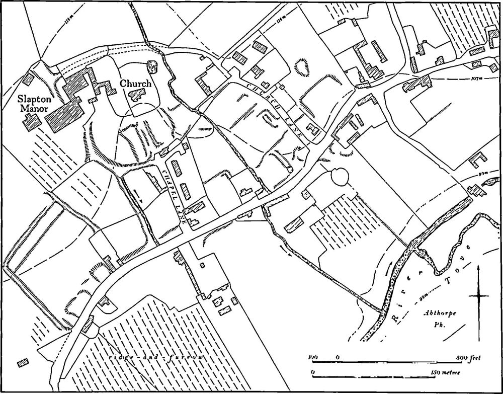
Fig. 105 Slapton (1) Settlement remains
a(1) Settlement Remains (centred SP 640467; Fig. 105), formerly part of Slapton, lie in and around the existing village, on limestone and clay between 99 m. and 114 m. above OD. The surviving earthworks complement the existing pattern of streets and houses, but do not make possible any interpretation of the development of the village. The greater part of the village is arranged along a single main street running N.E.-S.W., with many gaps between the existing buildings. In most of these gaps are fragmentary earthworks indicating that buildings stood there at some time. From this street two lanes extend N.W. towards the almost isolated church and manor house, standing on high ground. Until relatively recently these lanes ran on and encircled the church, churchyard and manor house; they remain as hollow-ways or public footpaths. Immediately to the S. of the church are at least four rectangular closes bounded by low scarps up to 1 m. high. These may only be abandoned paddocks, but they could be closes of houses formerly lining the old road to the S., part of which also survives as a hollow-way. Further E., along the S.W. side of Church Lane are other closes, extending down-slope from the lane with, at their N.E. ends, the remains of former buildings lining the lane.
It is not clear whether these earthworks represent a considerable reduction in village size, or are the result of changes in layout. No plans exist of Slapton before the 19th-century OS maps, which show the village much as it is today, and the surviving population statistics show no apparent reduction in its size.
In 1086 Domesday Book lists Slapton as a single manor with a total recorded population of 10 (VCH Northants., I (1902), 332), and 23 people paid the Lay Subsidy of 1301 (PRO, E179/155/31). In 1377, 60 people over the age of 14 paid the Poll Tax (PRO, E179/155/28). By 1673, 31 people in the village paid the Hearth Tax (PRO, E179/254/ 14) and Bridges (Hist. of Northants., I (1791), 256), writing in about 1720, said that there were about 35 families in the parish. In 1801 the population of the parish was 135.
If the earthworks do represent an alteration to the original form of Slapton village, it is difficult to see what changes were involved beyond, perhaps, a movement away from the church towards the present main street. (RAF VAP CPE/UK/1994, 3086–9; air photographs in NMR)
(2) Cultivation Remains. The common fields of the parish were finally enclosed by an Act of Parliament of 1759. However at least some enclosure had occurred long before that date for Bridges (Hist. of Northants., I (1791), 256) writing in about 1720, recorded that 'part of the Lordship is inclosed, and the rest is open field'.
Ridge-and-furrow of these fields exists on the ground or can be traced on air photographs over much of the parish, arranged in end-on and interlocked furlongs, many of reversed-S form. There appears to be very little land which has not been ploughed in ridge-and-furrow at some time and even the low-lying land in the S., along the R. Tove, has traces of it. (RAF VAP CPE/UK/1994, 3086–90)
Undated
a(3) Mound (SP 63774819), lies in the extreme N. corner of the parish, on Boulder Clay at 148 m. above OD. Here, at the highest point of the parish, a mound 13 m. in diam. and only 0.5 m. high is still visible. It has been ploughed over and there is no trace of a surrounding ditch. The suggestion that the mound is a barrow cannot be proved and it could be a windmill mound. (BNFAS, 3 (1969), I, incorrect grid reference; OS Record Cards; CPE/UK/1994, 3088–9)