An Inventory of the Historical Monuments in the County of Northamptonshire, Volume 4, Archaeological Sites in South-West Northamptonshire. Originally published by Her Majesty's Stationery Office, London, 1982.
This free content was digitised by double rekeying. All rights reserved.
'Whittlebury', in An Inventory of the Historical Monuments in the County of Northamptonshire, Volume 4, Archaeological Sites in South-West Northamptonshire(London, 1982), British History Online https://www.british-history.ac.uk/rchme/northants/vol4/pp167-171 [accessed 30 April 2025].
'Whittlebury', in An Inventory of the Historical Monuments in the County of Northamptonshire, Volume 4, Archaeological Sites in South-West Northamptonshire(London, 1982), British History Online, accessed April 30, 2025, https://www.british-history.ac.uk/rchme/northants/vol4/pp167-171.
"Whittlebury". An Inventory of the Historical Monuments in the County of Northamptonshire, Volume 4, Archaeological Sites in South-West Northamptonshire. (London, 1982), British History Online. Web. 30 April 2025. https://www.british-history.ac.uk/rchme/northants/vol4/pp167-171.
In this section
66 WHITTLEBURY
(OS 1:10000 a SP 74 NW, b SP 74 SW, c SP 64 NE, d SP 64 SE)
The parish, once a chapelry of Greens Norton, covers some 1000 hectares and is heavily wooded. It is almost entirely on Boulder Clay with small patches of glacial sands and gravels, and bands of Oolitic limestones in the valleys of the streams. The village lies at the highest point, in the W. of the parish, some 155 m. above OD, and from this point small streams radiate.
There are several Iron Age and Roman sites in the parish (1–4) including an important villa (4). A number of these sites lie within former woodland which, in medieval times at least, was part of Whittlewood Forest (Fig. 16).
Prehistoric and Roman
A hoard of coins, mainly Constantinian, was found before 1712 in the N. of the parish (around SP 699453; J. Morton, Nat. Hist, of Northants. (1712), 531; VCH Northants., I (1902), 219). In 1957 a single Roman pot base was discovered N.W. of the village (SP 68474472; OS Record Cards). A number of objects were found near the church in the 1820s. These included a small palstave, two Roman tiles (NM) stamped LEG XXVV (Legio XX Valeria Victrix), part of a quern and several Greek and Roman coins. These are thought to have been part of a modern collection and not to indicate a settlement. (Ant. J., 18 (1938), 45; G. Baker, Hist. of Northants., II (1836–41), 73; VCH Northants., I (1902), 215; NM Records; OS Record Cards)
c(1) Enclosure (SP 689431), S. of the village, within the formerly wooded area of the deer park, on Boulder Clay at about 150 m. above OD. Air photographs taken in 1947 (RAF VAP CPE/UK/1926, 2234–5) show an irregular four-sided ditched enclosure, roughly 80 m. by 50 m., with rounded corners and a small secondary enclosure attached at its S.W. corner. The feature still survived as an earthwork at that date, the ditch varying between 1 m. and 2 m. in depth, but it has since been ploughed and levelled. No dating evidence was noted but it is likely that this was an Iron Age enclosure which survived within the forested area until this century (OS Record Cards).
c(2) Enclosure (SP 687428), 300 m. S.W. of (1), in a similar situation. Air photographs taken in 1947 (RAF VAP CPE/UK/1926, 2234–5) show the earthworks of a small roughly oval enclosure, some 65 m. by 45 m. Though now totally destroyed it was probably an Iron Age settlement. OS Record Cards state that its surrounding bank was 2 m. across and 0.6 m. high with an outer ditch 1.4 m. deep.
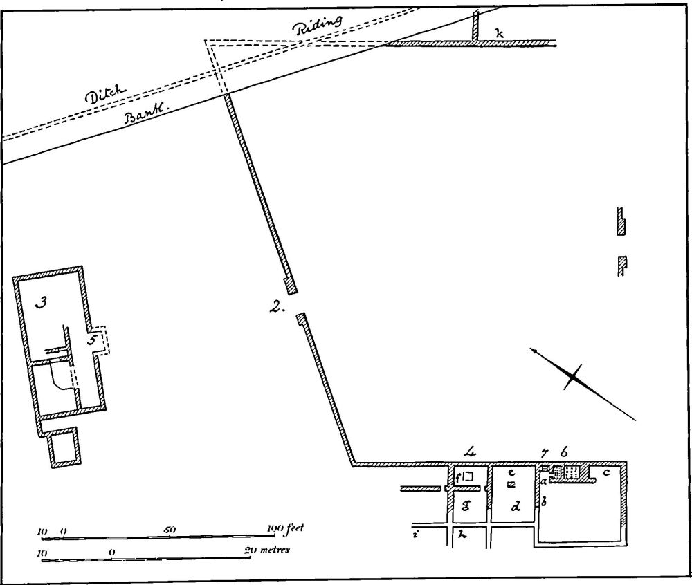
Fig. 123 Whittlebury (4) Roman villa (based on a plan in Arch. J.)
b(3) Iron Age Settlement (centred SP 721432), in the E. of the parish, within Whittlewood Forest, on Boulder Clay between 120 m. and 132 m. above OD. Several discrete scatters of Iron Age material have been found over an area of at least 20 hectares, since forest clearance and deep ploughing in 1956. Finds include areas of dark soil, burnt pebbles, cobbled floors, iron slag and worked flints associated with both early and mid Iron Age pottery (Wolverton and District Arch. Soc. Newsletter, 6 (1961), 2; BNFAS, 1 (1966), 5; Northants. Archaeol., 10 (1975), 152, 175).
b(4) Roman Villa (SP 73224457; Fig. 123), lies in the centre of the small E. projection of the parish, on Boulder Clay at 117 m. above OD. The site was discovered in a stone-pit and was excavated in 1850. Only a short report was written and many details on the published plan were not mentioned.
Two buildings were discovered. One, at the S. end of the site, contained at least 12 rooms including a bath suite, and there was a mosaic pavement, apparently comprising a grid of squares outlined in red with a square of white at each intersection. This building lay to the W. of a large courtyard. The second building lay to the N. and contained two mosaics: one, in the main part of the building, had a square central panel with a bust of a winged female wearing a wreath and probably holding a spray of leaves; the other had a pattern of red crosses. Finds included painted wall-plaster, a column base, tiles, pottery including samian, and coins from Tetricus to Maximianus. More buildings debris and pottery has been found scattered over a wide area since 1950. A 'small stone pedestal', possibly an altar, is also recorded. (Arch. J., 7 (1850), 172; JBAA, 6 (1851), 73; 7 (1852), 107, Pl. XI; VCH Northants., I (1902), 199–200; A. Rainey, Mosaics in Roman Britain (1973), 156, Pl. 14A; BAR, 41 (i) (1977), 152, No. 148; A. L. F. Rivet (ed.), The Roman Villa in Britain (1969), 143; OS Record Cards)
For Roman Roads ie, Watling Street, and 160a, see Appendix.
Medieval and Later
d(5) Settlement Remains (SP 690440), formerly part of Whittlebury, lie on the W. side of the main street of the village, on glacial sands and gravels at 152 m. above OD. Most of the street has houses on both sides, but a large open space has the remains of a row of former buildings set within fragmentary closes. (RAF VAP CPE/UK/1926, 5234– 5; Northants. Archaeol., 10 (1975), 174)
cd(6) Moat (SP 688450; Fig. 124), lies in an isolated position N. of the village at Lords Field Farm, on Boulder Clay at 145 m. above OD, with extensive views to the N.W. The site now consists of a sub-rectangular island, surrounded by a broad wet moat 1 m. deep with a causeway across it on the N.E. The island is uneven but no distinguishable features remain; the present farm lies to the N.E. The earliest detailed depiction of the site is on a map of about 1726 (NRO). This shows the island as rectangular, with a large building on it, and a bridge across the ditch on the E., near the S.E. corner, leading to other buildings which appear to be barns. On a later map of about 1767 (NRO) the same details are shown and a fenced paddock is depicted to the W. of the site. The moat is traditionally the site of the manor house of Whittlebury (G. Baker, Hist. of Northants., II (1836–41), 70).
c(7) Deserted Farmstead (SP 699451), lay N.E. of the village, on the N. side of a track leading to Pury End, Paulerspury, on Boulder Clay at 130 m. above OD. The site has been completely destroyed by modern cultivation and returned to pasture, but air photographs taken in 1947 (RAF VAP CPE/UK/1926, 3235–6, 5235–6) show a roughly rectangular enclosure, orientated N.W.-S.E., 150 m. by 90 m. bounded by a low bank and outer ditch. The interior was divided into at least two paddocks and in the N. corner there was an area of disturbed ground perhaps indicating the positions of former buildings. Ridge-and-furrow lay along the W. edge. The earthworks were probably the site of a medieval forest-edge farmstead.
d(8) Fishponds (SP 689444), lie on the N. side of the village immediately N. of the church, in the bottom of a shallow valley draining N., on Boulder Clay at 147 m. above OD. Three small embanked ponds, each about 20 m. wide, are arranged in a line along the old stream bed. They are probably medieval in origin.
(9) Cultivation Remains. The common fields of the parish were finally enclosed by an Act of Parliament of 1797. In 1600 most of the parish N. of the village was under open-field cultivation but by 1726 only the area immediately E., N. and W. of the village remained unenclosed (maps in NRO). The whole of the S. and S.E. of the parish was woodland in 1600 but large areas were cleared and cultivated during the following centuries.
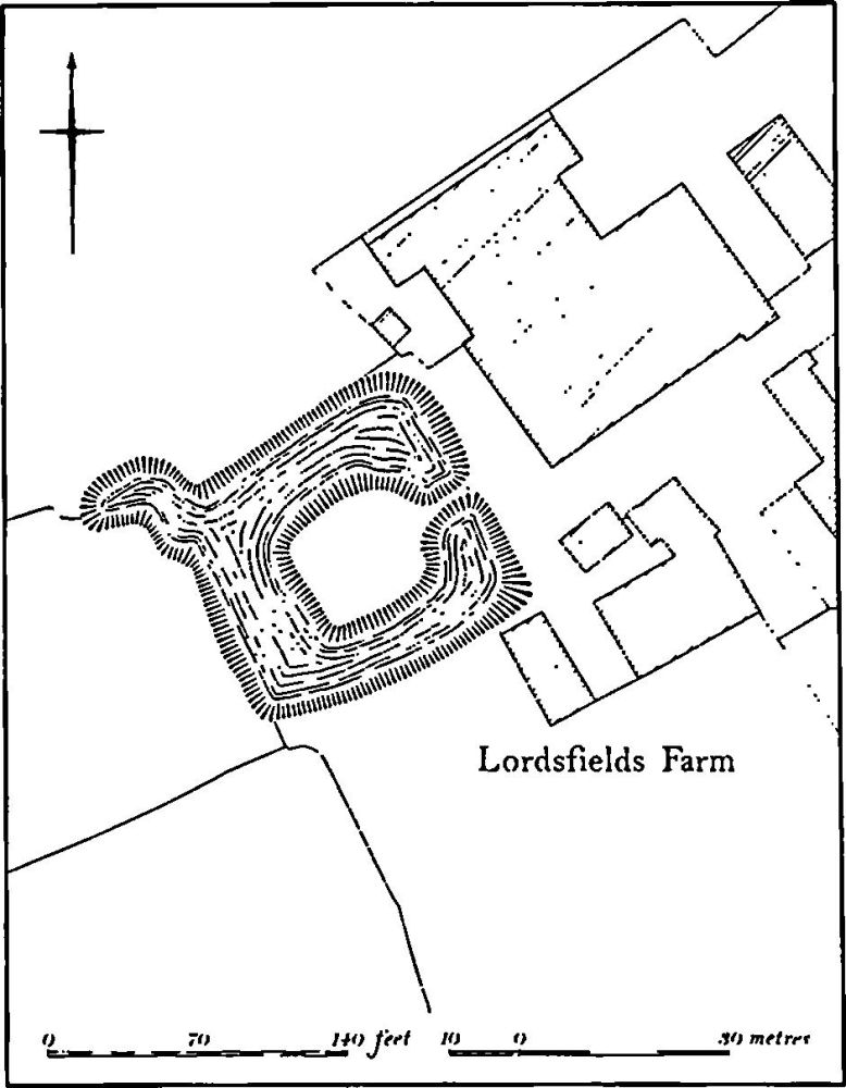
Fig. 124 Whittlebury (6) Moat
Ridge-and-furrow remains on the ground or can be traced on air photographs in a few places around the village itself where it is arranged in end-on and interlocked furlongs of normal medieval form. There are also fragmentary pieces in the N. of the parish in the area enclosed between 1600 and 1726. (RAF VAP CPE/UK/1926, 2234–40, 3233–6, 5232–42)
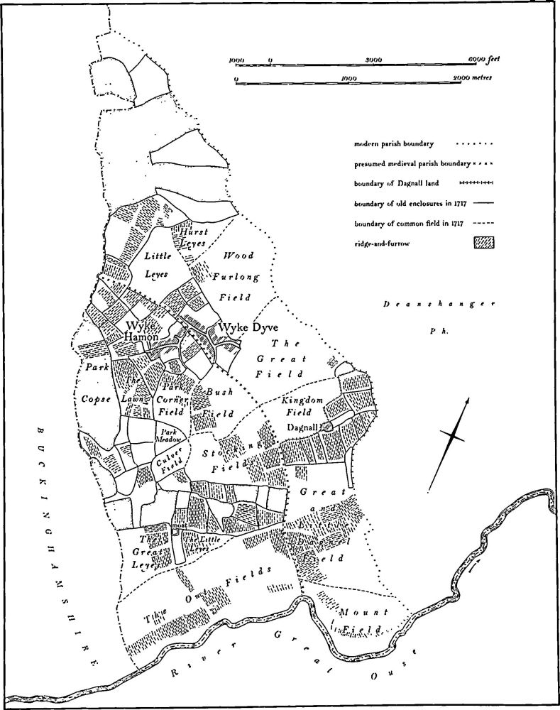
Fig. 125 Wicken Medieval settlements, parishes, estates and fields (based on a plan of 1717, NRO)
Undated
b(10) Ditched Trackway (?) (SP 712428) in the S. of the parish, immediately W. of Buckingham Thick Copse and close to the county boundary, on Boulder Clay at 122 m. above OD. Air photographs (NCAU) show a possible ditched trackway running S.E. from the edge of the copse and visible for some 200 m. At its N.W. end the alignment is continued by a modern ride through the copse. It is therefore unlikely to be an ancient feature.