An Inventory of the Historical Monuments in the County of Northamptonshire, Volume 4, Archaeological Sites in South-West Northamptonshire. Originally published by Her Majesty's Stationery Office, London, 1982.
This free content was digitised by double rekeying. All rights reserved.
'Wicken', in An Inventory of the Historical Monuments in the County of Northamptonshire, Volume 4, Archaeological Sites in South-West Northamptonshire(London, 1982), British History Online https://www.british-history.ac.uk/rchme/northants/vol4/pp171-172 [accessed 30 April 2025].
'Wicken', in An Inventory of the Historical Monuments in the County of Northamptonshire, Volume 4, Archaeological Sites in South-West Northamptonshire(London, 1982), British History Online, accessed April 30, 2025, https://www.british-history.ac.uk/rchme/northants/vol4/pp171-172.
"Wicken". An Inventory of the Historical Monuments in the County of Northamptonshire, Volume 4, Archaeological Sites in South-West Northamptonshire. (London, 1982), British History Online. Web. 30 April 2025. https://www.british-history.ac.uk/rchme/northants/vol4/pp171-172.
In this section
67 WICKEN
(OS 1:10000 a SP 74 SW, b SP 73 NW, c SP 73 NE)
The triangular parish, of some 930 hectares, lies N.W. of the Great Ouse which forms the S.E. boundary. Large areas of alluvium and river gravels occupy the Great Ouse flood plain at about 68 m. above OD. The higher land to the S. of the village and in Whittlewood Forest in the W., is covered by Boulder Clay, but in the valley of a small stream which runs across the centre of the parish broad patches of Oolite Limestone are exposed.
In the medieval period there were two villages (3), each the centre of a separate parish, but these were united in about 1586. In addition there was apparently a third settlement, now Dagnall Farm (4), and an isolated moated site (5) (Fig. 125).
Prehistoric and Roman
c(1) Ring Ditch (?) (SP 77053775), on the flood plain of the Great Ouse at 70 m. above OD. Air photographs (not seen by RCHM) are said to show a ring ditch and linear features (BNFAS, 5 (1971), 41).
c(2) Roman Building (SP 761377), in the S.E. of the parish, close to the Great Ouse, on river gravel at 77 m. above OD. Building stone, roof and flue tiles, with pottery including samian and 3rd and 4th-century coarse wares all discovered in 1965, indicate the existence of a Roman building (BNFAS, 1 (1966), 14).
Medieval and Later
b(3) Settlement Remains (centred SP 744393; Figs. 14 and 125), formerly part of Wicken, lie in and around the existing village, on limestone and Boulder Clay, between 85 m. and 90 m. above OD. The surviving earthworks, though minor, emphasize the dual character of the village. The names Wykes and Wickens Ambo (PN Northants. 107– 8) reflect the existence of two separate manors, also known as Wyke Dyve and Wyke Hamon, throughout the medieval period from Domesday Book onwards (VCH Northants., I (1902), 334–349). This tenurial division corresponds with the two parts of the village on either side of the E.-flowing stream. The N. part of the village, Wyke Dyve, is laid out along a main E.-W. street, and the S. part, Wyke Hamon, lies along a S.W.-N.E. lane. The main earthworks lie in the N. part of the village, along the N. side of Cross Tree Road, between the latter and the manor house (SP 744394). They consist of small rectangular paddocks, bounded by large banks up to 0.5 m. high and apparently made of stone rubble. They probably represent the gardens of houses which once lay along the road. To the N. and N.E. are other, more indeterminate scarps and banks as well as a roughly circular mound 0.75 m. high. The area was already devoid of buildings in 1717, and was then called The Warren (map in NRO). Earthworks to the S. of the stream, in the manor of Wyke Hamon, in a pasture field on the E. side of Leckhampstead Road, are also probably the remains of former houses and gardens. A single building still stood at the N. end of the site in 1717 and in 1841 (SP 743393; map in NRO). Other earthworks lie to the W. and S.W. on each side of Home Farm (SP 742393 and 742392); no buildings were shown in either place in 1717. The site of the parish church of Wyke Hamon, which is said to have stood at the S. end of the village and which was pulled down in 1619, has not been located. (RAF VAP CPE/UK/2097, 3179–80; air photographs in NMR)
c(4) Settlement Remains (SP 759391; Fig. 125), formerly part of Dagnall, lie immediately N.E. of Dagnall Farm in the E. of the parish, on glacial sands and gravels at 80 m. above OD. The name Dagnall is not recorded until 1319 (PN Northants., 108) but the settlement is presumably much older than that. It lay in the former parish of Wyke Dyve. As it is not listed separately in any of the national taxation records there is no indication of its size until 1717 (map in NRO) when only the present farm is depicted. It is possible that the settlement never consisted of anything more than a single farmstead and that the surviving earthworks are only abandoned paddocks.
The earthworks cover a roughly rectangular area 80 m. by 220 m., bounded on the N.E. and S.E. by modern hedges, by the farm on the S.W., and on the N.W. by a low bank and ditch which separate them from the adjacent ridge-and-furrow. Two low banks and ditches running N.W.-S.E. divide the area into three small closes. The southwesternmost of these has disturbed earthworks within it, perhaps the remains of old farm buildings (air photographs in NMR).
b(5) Moat (SP 749376; Figs. 125 and 126), lies in the S. of the parish, immediately S.E. of Rabbit Wood, on Boulder Clay at 85 m. above OD. The earthworks are on the S. side of a small N.E.-flowing stream and consist of a rectangular area bounded on the W., S. and E. by a ditch 8 m.–15 m. wide and up to 1.75 m. deep, cut back into rising ground on the S. The N. side is bounded by the stream and there is no trace of an original ditch. The interior is divided into two unequal parts by a subsidiary ditch which runs from the middle of the E. side and then curves towards the N. before fading out. There is a large inner bank along the N. side and the rest of the interior is uneven.
Nothing is known of the history of this site until the early 18th century when it is shown on a map of 1717 (NRO), lying at the N. end of a long, narrow field called The Grove Close and with a house standing within it. By 1841 (NRO, Tithe Map) the house had disappeared and only the W. side of the moat is depicted, as a pond. (RAF VAP 2F41, 543/RAF/1426, 0362–3; air photographs in NMR)
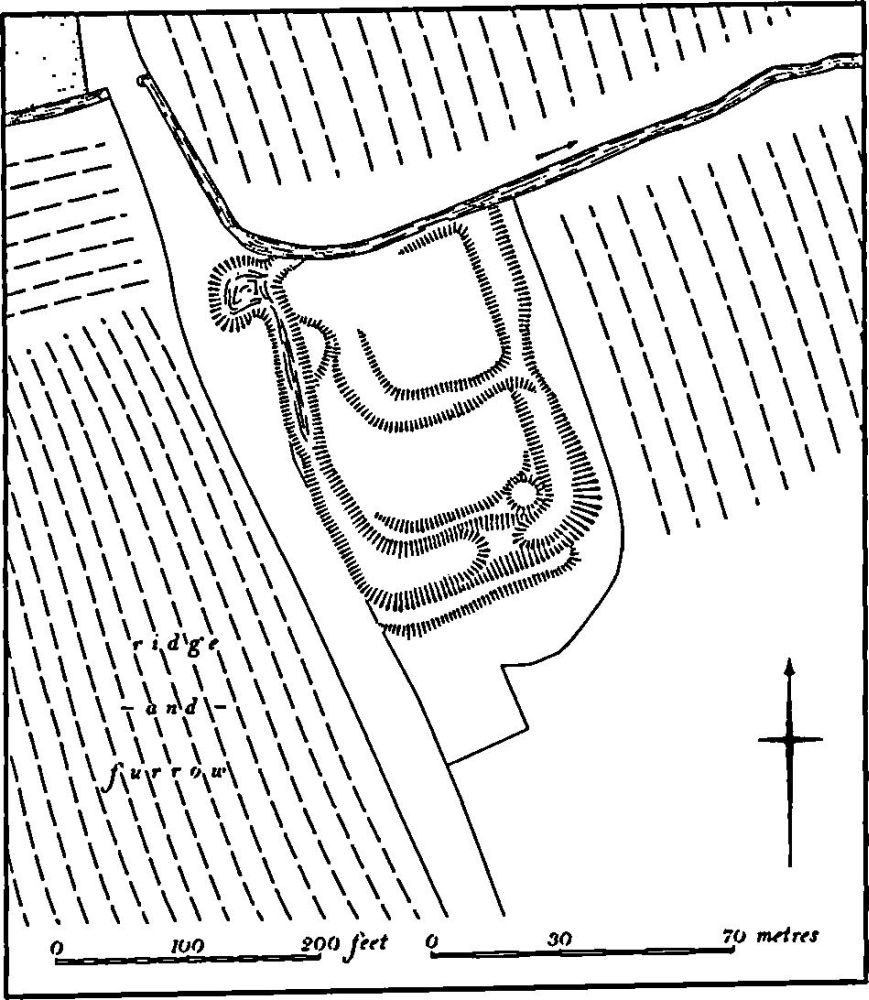
Fig. 126 Wicken (5) Moat
b(6) Deer Park (centred SP 738385; Fig. 125), lay in the W. of the parish, S.W. of the village, on Boulder Clay, at around 100 m. above OD. In the late 13th century John Fitzalan was granted licence to re-enclose his park which had fallen into decay. It was disparked about 1651 (Northants. P. and P., 5 (1975), 233). Its exact boundaries are not known but the park presumably lay in the area of the present Wicken Park although it may have extended further S. and E. for on the map of 1717 (NRO) the names Park Meadow, Park Corner Field and The Lawn are given to this area. No definite boundary has been noted though the existing woodlands are all surrounded by large banks. This is particularly true of Park Copse.
(7) Cultivation Remains (Fig. 125). The date of the enclosure of the common fields of Wicken is unknown but was between 1717 and 1841 (maps in NRO). Before enclosure there were at least ten named common fields, which probably related to the two separate villages and parishes of Wyke Dyve and Wyke Hamon and to the third medieval settlement at Dagnall Farm (4). It may be assumed that the boundary between the parishes followed the existing stream which flows from near the county boundary W. of the village (SP 735395) to a little S. of Wicken (SP 752390) and then continued as a curving line of modern hedges as far as the Buckingham Road (SP 758381) and thence to the Great Ouse (SP 762376). If this is so, Wyke Hamon occupied the S.W. part of the modern parish and Wyke Dyve the N.E. The land of Dagnall seems to have occupied the S.E. part of Wyke Dyve parish.
The common fields of Wyke Hamon consisted of four areas, of unequal size, immediately S. and S.E. of the village. In 1717 these were known as Bush, Park Corner, Culver and Stocking Fields. To the W., between these fields and the county boundary, lay a large area of old enclosures and woodland, part of which may have been the medieval deer park (6). To the S. of the common fields was a smaller area of copses and old enclosures and beyond them, extending to the Buckingham Road, was a large area known as Great and Little Leys. To the S.E. of the road, between it and the Great Ouse, lay an extensive tract of common arable land known as The Out Fields. Ridge-and-furrow of these fields exists on the ground or can be traced on air photographs over large parts of the medieval parish. None is visible in Culver Field but fragments of rectangular, curved and reversed-S furlongs exist in Park Corner Field (SP 744390), Bush Field (SP 748390) and Stocking Field (SP 755385). In the old enclosures to the S.E., N. and E. of Park Copse there is a continuous expanse of ridge-and-furrow arranged in rectangular interlocked furlongs many with reversed-S curves and with well-marked headlands between them. The character of this ridge-and-furrow suggests that it was formerly part of the common fields. Some of it certainly lay within woodland in 1717 (e.g. SP 736389). Ridge-and-furrow also survives within the former old enclosures S.E. of the known common fields (centred SP 753381) as well as in the Great and Little Leys (SP 749375) and in The Out Field. In the latter the ridges run downhill to the river.
Wyke Dyve appears to have had three open fields, Wood Furlong Field to the N. of the village. The Great Field to the E. of the village, and Kingdom Field further S.E. The whole of the N.W. of the parish was covered either by woodland or by open land known as Old Leys, Hurst Leys and Old Sale. Ridge-and-furrow of these fields survives or can be traced from air photographs. Only a few slight fragments are visible within the three open fields (e.g. SP 756395) but more is traceable within Old Sale and Hurst Leys to the N.W. of the village (SP 738400).
The settlement at Dagnall Farm was situated on the S.E. side of Kingdom Field. In 1717 there were old enclosures immediately to the N.E., E. and S. of it and further S. lay a large open field known as Great and Little Dagnel Field and a smaller one called Mount Field. To judge from their relative areas and their names it appears that these were formerly three open fields. Ridge-and-furrow of these fields survives on the ground or can be traced on air photographs in a number of places. In Great and Little Dagnel Field there is an expanse of end-on and interlocked rectangular furlongs (centred SP 762383) but only fragments survive in the former Mount Field alongside the Great Ouse (SP 763377–772377). Almost all the old enclosures have well-marked ridge-and-furrow lying within them. (RAF VAP CPE/UK/1926, 4233–43; CPE/UK/1929, 1184–93, 3190–4; CPE/UK/2097, 3179–83; F21, 58/RAF/5517, 0024–6; 2F41, 543/RAF/1426, 0362–6)