An Inventory of the Historical Monuments in the County of Northamptonshire, Volume 4, Archaeological Sites in South-West Northamptonshire. Originally published by Her Majesty's Stationery Office, London, 1982.
This free content was digitised by double rekeying. All rights reserved.
'Blisworth', in An Inventory of the Historical Monuments in the County of Northamptonshire, Volume 4, Archaeological Sites in South-West Northamptonshire(London, 1982), British History Online https://www.british-history.ac.uk/rchme/northants/vol4/pp17-19 [accessed 30 April 2025].
'Blisworth', in An Inventory of the Historical Monuments in the County of Northamptonshire, Volume 4, Archaeological Sites in South-West Northamptonshire(London, 1982), British History Online, accessed April 30, 2025, https://www.british-history.ac.uk/rchme/northants/vol4/pp17-19.
"Blisworth". An Inventory of the Historical Monuments in the County of Northamptonshire, Volume 4, Archaeological Sites in South-West Northamptonshire. (London, 1982), British History Online. Web. 30 April 2025. https://www.british-history.ac.uk/rchme/northants/vol4/pp17-19.
In this section
7 BLISWORTH
(OS 1:10000 a SP 75 NW, b SP 75 SW)
The parish is of irregular shape, covering almost 800 hectares. The N. part is a rather flat area of Upper Lias Clay, glacial sands and gravels and alluvium, all at about 84 m. above OD, but from there the land rises steeply, exposing narrow bands of Northampton Sand, Blisworth Limestone and other Oolitic deposits, to a high ridge covered by Boulder Clay with a maximum height of 130 m. above OD. A N.-flowing stream has cut a steep-sided, narrow valley, now occupied by the Grand Union Canal which then passes below the ridge in a tunnel.
Prehistoric and Roman
A gold stater of Tasciovanus (Mack, 167) was found in the S.W. of the parish around 1950 (SP 720524; NM; S. S. Frere (ed.), Problems of the Iron Age in S. Britain (1958), 223; NM Records). Another, listed under Gayton, may have come from Blisworth. Part of a quern, possibly Roman, was found in 1969 (SP 71935404; NM; BNFAS, 4 (1970), 6).
b(1) Round Barrow (?) (SP 73435160), on Blisworth Hill in the S. of the parish, on Boulder Clay at 125 m. above OD. The mound is situated in a field called Bury Hill in 1729 (map in NRO); it is circular, 16 m. in diam. and 0.25 m. high, with slight traces of a surrounding ditch about 3 m. across. The field has slight traces of ridge-and-furrow in it but it is impossible to say if this pre-dates the mound. The mound may be a barrow, but could also be a medieval windmill mound. (BNFAS, 5 (1971), 1; RAF VAP CPE/UK/1926, 1029–30)
ab(2) Enclosure (SP 727550), lies in the N. of the parish, on Upper Lias Clay at 80 m. above OD. Air photographs (not seen by RCHM) are said to show a rectangular enclosure of just under 1 hectare, perhaps with other enclosures attached to it on the N. (BNFAS, 6 (1971), 3).
b(3) Roman Settlement (unlocated but possibly around SP 735530), believed to have been discovered in the 19th century during ironstone-quarrying S.E. of the village, on Blisworth Limestone at just over 122 m. above OD. Roman coins, pottery and 'ornaments', some from wells or pits, are recorded from the parish (VCH Northants., I (1902), 216; T. J. George, Arch. Survey of Northants. (1904), 10). Worked flints are also documented.
b(4) Roman Settlement (?) (SP 733536), in a restored quarry E. of the village, on Northampton Sand, at 145 m. above OD. Roman pottery has been found on reclaimed land, in soil taken from the adjacent area (inf. D. N. Hall).
For Roman settlement at SP 712529, see Gayton (3).
Medieval and Later
b(5) Settlement Remains (SP 726537), formerly part of Blisworth, lay at the N. end of the village, immediately N. of Chapel Lane and Little Lane. The earthworks, in existence until at least 1947 (RAF VAP CPE/UK/1926, 3030– 1), have now been destroyed, but consisted of a group of small rectangular paddocks bounded by low banks, presumably the gardens of houses that once stood along the lane. Some of the houses remained until after 1810 for they are depicted on the draft Enclosure Map of that date (NRO) as well as on a map of the parish of 1729 (NRO).
b(6) Tramway (SP 743500–724533; Fig. 32), extends for 3.8 km. over Blisworth Hill, between Blisworth and Stoke Bruerne. It was build in 1800–1 to carry the freight of the Grand Junction Canal over the hill during the construction of Blisworth Tunnel. The construction of the tunnel started in 1793, but difficulties with flooding and contractors continually held up the work. By the end of 1796, when there was still no prospect of the tunnel's early completion, it was proposed that a road be constructed over the hill to join the two already complete sections of the canal. The road was not a success and in March 1799, it was decided that it should be replaced by a tramway. This was finished by 1801 and was in use until February 1805 when the tunnel was finally completed. The tramway was then abandoned and its track was reused on the Northampton Tramway (see Rothersthorpe (6)). The rails used for the line were L-shaped in section and were fixed to stone sleepers with the horizontal flange facing outwards (examples in Stoke Bruerne Waterways Museum). The wagons therefore had flangeless wheels and elaborate sidings were not necessary as wagons could simply be run off the track and parked. The gauge of the track was probably 4 ft. 2 in. Although no record survives it seems likely that the N. end of the tramway was later used to carry stone from the Blisworth quarries to the canal wharves. (A. H. Faulkner, The Grand Junction Canal (1972), 42–60; Northants. Ant. Soc. Rep., 64 (1962–3), 14–26).
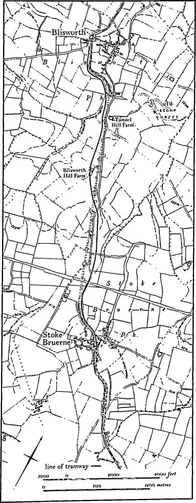
Fig. 32 Blisworth (6) Tramway
The S. end of the tramway lay S.E. of Stoke Bruerne, on the E. side of the canal where the Northampton to Stony Stratford road crosses it (SP 74894919). No trace of it survives for the first 1200 m. to the N., but it probably ran N.W. alongside the existing towpath. At the point where the canal enters the cutting leading to the S. entrance of Blisworth Tunnel (SP 74135006) the line of the tramway is visible as a ledge or terrace, 4 m.–5 m. wide, climbing the hillside, parallel to the cutting. This terrace continues beyond the tunnel entrance until it meets a lane running S. from the Blisworth-Stoke Bruerne Road (SP 73885033). For the next 300 m. the lane takes the original line of the tramway as it ascends the steep S. side of the hill and no trace of the tramway exists. Then (at SP 73865070) the lane swings N.W. and in a small triangular copse the tramway is again visible as a terrace 5 m. wide. Beyond the copse, as the top of the hill is reached, no trace of the tramway can be seen except for a line of stones 5 m.–6 m. wide across an arable field.
At the point where it enters Blisworth parish (SP 73765094) the tramway appears as a broad stony ridge 10 m. wide and 0.25 m. high crossing a green lane. This ridge continues N.N.W. for 350 m. in a pasture field. At the N. end of this field it cuts across an area of rather narrow ridge-and-furrow. Beyond the field it continues for a further 140 m. until it reaches the Blisworth-Stoke Bruerne Road. Along this section the remains have been ploughed over but survive partly as a low embankment and partly as a shallow cutting 15 m. across. At the point where it crossed the road (SP 73525141) the tramway turned N.W. and the line continues as a low embankment 0.25 m. high and 12 m. wide for a distance of 230 m. Midway along this section (SP 73425155) the embankment is partly overlaid by the tail of one of the spoil heaps from the canal tunnel which lies directly below. From this point the tramway starts to descend the N. side of Blisworth Hill and for the next 200 m. the remains take the form of a shallow cutting, crossing two adjacent furlongs of reversed-S ridge-and-furrow. At Blisworth Hill Farm (SP 73195189) the tramway turned N. but any trace has been obscured by farm buildings. To the N. of the farm, for some 500 m., the remains of the tramway have been ploughed over and only a broad cutting up to 20 m. wide and 1.5 m. deep survives, in a very degraded form. Immediately S.W. of Tunnel Hill Farm (SP 73005253) the alignment again turns N.N.W. and is visible for 230 m. as a broad cutting passing between piles of spoil from the canal tunnel. Beyond, the tramway survives as a massive embankment over 3 m. high and some 70 m. long crossing a small valley after which it passes on to the level summit of another spoil heap (SP 72905282). This point probably marks the position of winding machinery which drew the wagons up the very steep incline to the N. The incline can be traced as a cutting or terrace running in a broad curve N.W. and then W. above and roughly parallel to the canal as it enters the N. portals of the tunnel. To the S. of the village (SP 72505307) the tramway reached the level of the canal and continued along the W. side of it until it reached wharves at Blisworth (SP 72385335). Along this section it survives as a broad embankment.
In 1969 an excavation was carried out on the line of the tramway in the extreme S. of Blisworth parish (SP 736513). Four rows of stone sleeper blocks, two rows for each track, were found (BNFAS, 4 (1970), 30).
Although there is no documentary proof, a section of the tramway to the N. of the tunnel entrance to Blisworth may have had a later use. At its S. end, above the tunnel, a secondary cutting runs S.E. and then E. and appears to be heading towards the stone quarries further E. and N.E. In addition the discovery, during fieldwork on the incline, of a cast iron chair to take a rail of conventional type suggests that a later track had at some time replaced that of 1800–5. (RAF VAP CPE/UK/1926, 1029–30, 1242–3, 3029– 1)
(7) Cultivation Remains. The common fields of the parish were enclosed by an Act of Parliament of 1808 (NRO, Draft Enclosure Map, 1808). By that time the whole of the S. part of the parish centred on Blisworth Hill was already enclosed, as well as a large area N.W. of the village and a narrow strip N. of the village on the W. side of the main A43 road. Until enclosure the remaining land was divided into four open fields. Windmill Field lay to the N.E. of the village, Nether Field to the N.W., Long Stockin Field to the S.E. and Wood Field to the S.W. An earlier map, of 1729 (NRO) shows exactly the same situation except that in the extreme S.W. a small area was named Wooley Field. Ridge-and-furrow of these and earlier fields exists on the ground or can be traced on air photographs over parts of the parish. Most of the traceable remains lie on the summit and slopes of Blisworth Hill, which was already enclosed by 1729. Here as elsewhere, the ridge-and-furrow is arranged in end-on and interlocked furlongs, and it would appear that most of this area was under normal strip-field cultivation at some time. Similar ridge-and-furrow is traceable in other areas of old enclosures to the W. and N. of the village. Ridge-and-furrow in the area covered by the four open fields up to 1808 survives in a few places and where it is complete it agrees exactly with the furlongs and direction of strips shown on the draft Enclosure Map. It is notable that in the N.E. of the parish, against the Milton Malsor parish boundary (SP 731542), the location as well as the furlong names, Lower, Middle and Upper Breach Furlongs, would suggest a late intake of land. The ridge-and-furrow is laid out in large blocks neatly related to adjacent furlongs and does not appear to be the result of infilling of small irregular areas left uncultivated at an earlier period. (RAF VAP CPE/UK/1926, 1028–31, 3029–33, 5028–31; FSL 6565, 1796–8, 1997–9, 2015–9)