An Inventory of the Historical Monuments in Westmorland. Originally published by His Majesty's Stationery Office, London, 1936.
This free content was digitised by double rekeying. All rights reserved.
'Hugill or Ings', in An Inventory of the Historical Monuments in Westmorland(London, 1936), British History Online https://www.british-history.ac.uk/rchme/westm/pp114-116 [accessed 30 April 2025].
'Hugill or Ings', in An Inventory of the Historical Monuments in Westmorland(London, 1936), British History Online, accessed April 30, 2025, https://www.british-history.ac.uk/rchme/westm/pp114-116.
"Hugill or Ings". An Inventory of the Historical Monuments in Westmorland. (London, 1936), British History Online. Web. 30 April 2025. https://www.british-history.ac.uk/rchme/westm/pp114-116.
In this section
42 HUGILL OR INGS (C.e.)
(O.S. 6 in. (a)XXVII, S.W., (b)XXXIII, N.W.)
Hugill is a parish 6 m. N.W. of Kendal. The Village Settlement is the principal monument.
Ecclesiastical
b(1). Parish Church of St. Anne, in the S. part of the parish, was built in 1743. The earlier building, a chapel of Kendal, stood at Grassgarth over ½ m. to the N.W. The existing church contains the following ancient:—
Fittings—Door: In W. doorway, modern but fitted with a wooden stock-lock dated 1682. Plate: includes a cup and cover-paten of 1634, given by Rowland Willson, 1634, both pieces with shield-of-arms. Table: In vestry—with turned legs and enriched top-rail, 17th-century.
Condition—Rebuilt.
Secular
b(2). Ulthwaite Bridge, over the river Kent, 1¾ m. N.N.E. of the church, is a single-span structure of rubble with a plain segmental arch. The span is about 33 ft. and the width 11 ft. It is probably of the 17th century.
Condition—Good.
b(3). High House, 1¼ m. N.N.W. of the church, is of two storeys; the walls are of rubble and the roofs are slate-covered. The house, formerly belonging to the Braithwaite family, is of irregular half H-shaped plan with the wings extending towards the S.E. It was built probably late in the 16th or early in the 17th century, but the N.E. end of the main block and the two projecting wings are probably later additions. The thick walls and a moulded beam in the northernmost wing may indicate an earlier origin for this part of the building. The central chimney-stack has a tapering circular shaft. The doorway in the porch has a door of nail-studded battens. Inside the building some of the ceiling-beams are exposed. The kitchen has a two-stage cupboard of the local type, the upper part having turned pendants and a carved fascia with the date 1687; the middle panel of the upper stage has arabesque ornament; the fireplace has an 18th-century moulded surround. There are some 17th-century panelled doors elsewhere in the house and in the northern wing is an early 16th-century moulded ceiling-beam, probably re-used.
Condition—Good.
Monuments (4–12)
The following monuments, unless otherwise described, are of the 17th century and of two storeys; the walls are of rubble and the roofs are slate-covered. Some of the buildings have exposed ceiling-beams.
Condition—Good or fairly good, unless noted.
b(4). Ings Hall, 220 yards W.S.W. of the church, was heightened and extended towards the S.W. and N.W. in the 18th century. Inside the building, the kitchen contains a cupboard of the local type, with turned pendants and enriched fascia to the upper part; a panel on the back has the incised date 1616, but this does not appear to be original. A second cupboard has a panelled door enriched with lozenges and part of a partition of moulded muntins and planks remains.
b(5). Hill Farm, house, 420 yards W.N.W. of the church. Inside the building is a moulded muntin and plank partition of the local type. The well of the staircase is lined with original panelling.
b(6). Hill Cottage, 50 yards W. of (5).
b(7). House, two tenements at Grassgarth, 1,050 yards N.N.W. of the church, has an original newel-staircase, partly projecting from the front.
b(8). St. Ann's Farm, house, 120 yards N. of (7), is said to occupy the site of the former chapel and perhaps to incorporate remains of its structure; there is, however, no visible evidence of this.
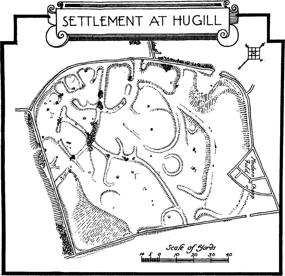
Settlement at Hugill
b(9). House, N.E. of Hugill Hall and 1,220 yards N.N.E. of the church, is ruined. Under the S.W. end is a barrel-vaulted cellar.
Condition—Ruined.
b(10). Rawgill, house, ½ m. N.E. of the church, is partly of three storeys. It was built late in the 17th or early in the 18th century.
b(11). Lower Reston, house, now two tenements, 1,180 yards E. of the church.
a(12). Croft Head, house, about 1¾ m. N.N.E. of the church, contains a moulded muntin and plank partition of the local type.
Unclassified
b(13). Village Settlement (790 ft. above O.D.), on the W. border of the parish 1½ m. N.N.W. of the church, is situated in a slight fold of the hillside. The site is enclosed by a modern stone wall built for almost its entire circuit on the top of the bank of the original enclosing wall. This enclosure was roughly rectangular with rounded corners, except for the S.E. corner, which was practically square. In modern times the enclosing wall has been carried on to form a salient at the N.E. angle and a sheepfold erected; the latter obliterates the line of the original embankment, which, however, is seen again as it emerges from the S.E. side of the sheepfold. The edging stones, which still remain in situ in this particular portion of the bank, show the wall to have varied in thickness from 10 to 14 ft. There were probably three entrances, the first near the middle of the W. side, where the opening gave access to a passageway leading towards the middle of the village; this passage has entrances opening into several small enclosures. Externally, some 8 yards from this entrance, is a large pile of stones which may have served as a traverse, though, alternatively, it may have been formed by the clearance of debris from the grazing-ground. The second entrance was probably in the S. wall, where a break can still be seen in the rampart. The third entrance has been stated by other investigators of the site to have been in the lower half of the E. side where, again, there are signs of a break in the rampart; it would appear, however, that the original entrance on the E. was farther N. where the bank on the N. side of the opening is curved inwards and then outwards again as it abuts on the opening. With regard to the lower gap on this side, referred to above, nothing definite can be said—it may represent a later entrance or merely a comparatively modern gap.
Internally the ground falls slightly from N. to S. and is divided into terraces of irregular sizes and shapes on which may be traced the foundations of a number of irregular enclosures, walls and hut-circles, the disposition of which is best seen by reference to the plan. Almost immediately N. of the W. entrance a rough line or bank of stones runs in a W.N.W. direction for approximately 175 ft. along the base of the modern wall; it is possible that this gave additional cover to the approach to this entrance (C. and W. Trans., O.S. VI. 86; N.S. XII. 6; XIV. 460).
Condition—Fairly good.