An Inventory of the Historical Monuments in Westmorland. Originally published by His Majesty's Stationery Office, London, 1936.
This free content was digitised by double rekeying. All rights reserved.
'Mallerstang', in An Inventory of the Historical Monuments in Westmorland(London, 1936), British History Online https://www.british-history.ac.uk/rchme/westm/pp162-165 [accessed 1 May 2025].
'Mallerstang', in An Inventory of the Historical Monuments in Westmorland(London, 1936), British History Online, accessed May 1, 2025, https://www.british-history.ac.uk/rchme/westm/pp162-165.
"Mallerstang". An Inventory of the Historical Monuments in Westmorland. (London, 1936), British History Online. Web. 1 May 2025. https://www.british-history.ac.uk/rchme/westm/pp162-165.
In this section
60 MALLERSTANG (G.e.)
(O.S. 6 in. (a)XXX, N.E., (b)XXX, S.E., (c)XXXVI, N.E.)
Mallerstang is a parish in the upper Eden valley 5 m. S. of Kirkby Stephen. The chapel and Pendragon Castle are the principal monuments.
Ecclesiastical
b(1). Parish Church of St. Mary, formerly a chapel of Kirkby Stephen, stands at Outhgill near the middle of the parish. The walls are of local limestone rubble with dressings of the same material and the roofs are covered with slates. There was a chapel here in the Middle Ages, but the existing structure was repaired and largely re-built in 1663 by Lady Anne Clifford, Countess of Pembroke, after having lain ruinous for 50 or 60 years. It was again restored in 1768, in 1879 and in 1909.
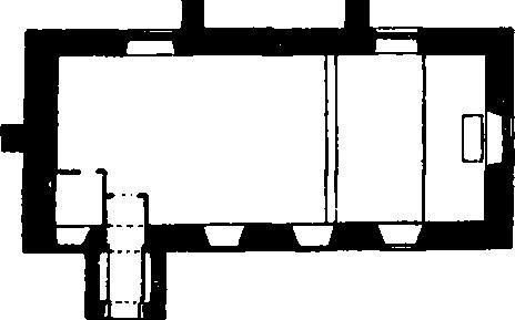
The Church, Plan
Architectural Description—The Chancel and Nave (49½ ft. by 19½ ft.) are structurally undivided. The E. window is modern. In the N. wall are two 17th-century windows, each of three square-headed lights, but the eastern window has been enlarged and has a transom. In the S. wall are three 18th-century windows and high up at the W. end is a window of two square-headed lights perhaps also of the 18th-century as the sill is formed of the original inscribed slab from the S. porch, still partly legible; the 17th-century S. doorway has moulded jambs and round head. The W. wall has a buttress with remains of an inscription recording a repair of 1768; on the gable is a bell-cote with a round-headed opening for one bell.
The South Porch has an outer doorway with a modern head; above it is a modern copy of the 17th-century inscription referred to above; it reads, "This chapple of Mallerstang after itt had layne ruinous and decayed some 50 or 60 years, was newe repayred by the Lady Anne Clifford countesse dowager of Pembroke, Dorsett and Montgomery, in the year 1663; who allsoe endowed the same with lands which she purchased in Cawtley, near Sedbergh to the yearly value of eleaven pounds for ever. Isaiah chap. 58. ver. 12. God's name be praised."
Fittings—Bell: one; uninscribed but of longwaisted type, probably 13th-century. Font: tapering octagonal shaft with moulded base and capping and shallow bowl in top; cover of oak and of octagonal pyramidal form with ball at top; probably 18th-century. Royal Arms: On W. wall—wooden panel with painted Stuart arms, the initials and date C.R. 1663 A.P. (for Anne Pembroke).
Condition—Good.
Secular
c(2). Lady's Pillar (Plate 37), on Hugh's Seat about 2¼ m. S.E. of the chapel, was a structure of unknown form, built of squared stone. It presumably fell at some uncertain date and the materials have been piled up in a roughly pyramidal form, possibly in 1890, the date cut on one of the stones. The pillar was erected by Lady Anne Clifford and one of the stones bears her initials and date, A.P. 1664.
Condition—Bad.
b(3). Pendragon Castle (Plate 141), ruin and earthworks, on the right bank of the Eden ¾ m. N. of the chapel. The castle was built apparently as an isolated tower or keep at the end of the 12th century. It passed to the families of Vipont and Clifford and Robert de Clifford is said to have strengthened it c. 1300. It was burnt by the Scots in 1341 and restored by Roger de Clifford c. 1360–70. According to Leland it was standing in 1539 but was again burnt by the Scots in 1541. The castle was restored by Lady Anne Clifford in 1660, who also built an enclosing wall, two gates, stables and outbuildings, all of which have disappeared. The tower was dismantled about 1685 but was still standing to its full height when Buck's and Pennant's views were taken. Since then the decay of the structure has been continuous and it is now hardly anywhere standing above the second storey and the existing walls are heavily encumbered both inside and out by fallen masonry, which obscures many of the still existing features. The walls are of local rubble with dressings of the same material.

Pendragon Castle, Mallerstang
The castle is of much interest as an early example of the isolated type of building generally called a peletower.
The Castle (about 64 ft. square externally without the buttresses and about 42½ ft. square internally at the second storey level) was formerly of three storeys and has shallow clasping buttresses at the angles. The entrance was formerly on the N. side but is now either destroyed or completely covered by fallen material. None of the features of the ground storey are now accessible except the barrel-vaulted chambers in the N.E. and S.W. angles; the former is now entered by an enlargement of an original window in the outer E. wall and there is an original doorway opening into the interior of the tower, but now blocked by debris. An original round-headed window, without dressings, remains in the S. face, and another, with dressings, in the W. face; both are blocked from within by fallen debris. The second storey had, in each angle, a barrel-vaulted chamber of which that in the S.W. angle retains part of its vault and an original round-headed doorway from the main apartment; this doorway has moulded splays and some masons' marks. The other angle chambers have been largely destroyed; the N.W. angle seems to have also contained a staircase. In the main E. wall, the tall central fragment retains the jambs of two original windows; they were probably of two lights with jambs and round arch of two orders, the outer chamfered and the inner moulded; above them is part of the oversailing course of the destroyed top storey. Only one splay remains of a similar window in the W. wall. The N. and S. walls each formerly contained a large window, probably inserted in the 17th century; both have now disappeared. Projecting from the S.W. angle of the building is an added garderobe tower set diagonally and probably of mediæval date and partly filled in with later blocking; it is lit by square-headed loops and has a discharge shute at the base. Remains of cusped window heads and other moulded stones are lying on the site.
The Earthworks consist of a deep ditch enclosing the site on the side away from the river; this ditch with the steep scarp towards the river forms a roughly circular enclosure. There are two causeways, crossing the ditch, that on the N.W. being probably the original entrance. There are foundation-mounds to the N.W. of the ditch.
Condition—Ruined and dangerous.
b(4). Castle Bridge, over the Eden, 200 yards N. of (3), is a rubble structure of one span with a segmental arch. It is said to have been built by Lady Anne Clifford and has subsequently been doubled in width.
Condition—Good.
Monuments (5–16)
The following monuments, unless otherwise described, are of the 17th century and of two storeys; the walls are of rubble and the roofs are slate-covered. Some of the buildings have exposed ceiling-beams.
Condition—Good or fairly good.
b(5). House, at Castlethwaite, 350 yards E. of (3), has a doorway with an enriched lintel and the date 1664; there is also an original window of two round-headed lights. Inside the building is an original fireplace with an enrichment of curves cut on the face of the lintel.
b(6). House, 25 yards N. of (5), has a re-set tablet over the doorway, with the initials and date A.F. 1688. There is an original window on the E. side of two round-headed lights with a moulded label.
b(7). Sandpot, house 320 yards W. of (3), retains an original doorway with a triangular arch in a square head.
a(8). Outbuilding at Blue Grass, 1¾ m. N. of the chapel, is probably of the 18th century but incorporates a 17th-century round arch of one moulded order. A second outbuilding incorporates a small round arch or head.
b(9). Outbuilding at Outhgill, 190 yards N. of the chapel, was probably re-built in the 18th century but incorporates a door-lintel inscribed "Hospes inire jubet justos exire nefastos H. and D.S. 1665."
b(10). Outbuilding, 70 yards N. of the chapel, is perhaps of the 18th century but incorporates a 17th-century doorway and window, the latter of two segmental-headed lights.
c(11). Deepgill, house nearly ¾ m. S.S.W. of the chapel, retains an original window and a panelled door.
c(12). Hazelgill, two tenements, 600 yards S. of (11), retains an original doorway with a triangular arch in a square head.
c(13). Hall Hill, house ¼ m. S. of (12).
c(14). Little Ing, house (Plate 23) ¼ m. E.S.E. of (13).
c(15). Elmgill, house 170 yards S. of (14), has a doorway with the date 1669.
c(16). Ing Heads, house nearly 1¾ m. S. of the chapel, was perhaps re-built in the 18th century. It incorporates a door-lintel with the initials and date T.S.M. 1688.
Unclassified
a(17). Village Settlement (about 710 ft. above O.D.) on the S. bank of the Eden nearly 2 m. N.N.W. of the church, has remains of two circular sinkings, perhaps huts, traces of walling and an irregular sinking. The remains are ill-defined and fragmentary.
Condition—Bad.
a(18). Cairns, immediately to the W. of (17), are three in number. (a) 80 yards W.S.W. of the ford, is about 66 ft. in diameter and 4½ ft. high. (b) 45 yards S. of (a), is about 20 ft. in diameter and 1½–2 ft. high. It was excavated by Greenwell (Brit. Barrows No. CLXIX), who suggests that the larger stones found formed part of an enclosing circle. In the centre, 1¼ ft. below the natural surface, was a hollow, covered by a flat stone and containing the burnt bones of a child, perhaps a portion of a pin and a Bronze-age incense-cup (now in Brit. Mus.). (c) 70 yards E.S.E. of (b), about 24 ft. in diameter and 2½ ft. high.
a(19). Mounds in the form of pillow-mounds, about 100 yards E. of (17), are four in number. They vary from 8 to 13 yards long by 5 yards wide and 3 to 4 ft. high; all are surrounded by ditches.