An Inventory of the Historical Monuments in Westmorland. Originally published by His Majesty's Stationery Office, London, 1936.
This free content was digitised by double rekeying. All rights reserved.
'Martindale', in An Inventory of the Historical Monuments in Westmorland(London, 1936), British History Online https://www.british-history.ac.uk/rchme/westm/pp165-167 [accessed 30 April 2025].
'Martindale', in An Inventory of the Historical Monuments in Westmorland(London, 1936), British History Online, accessed April 30, 2025, https://www.british-history.ac.uk/rchme/westm/pp165-167.
"Martindale". An Inventory of the Historical Monuments in Westmorland. (London, 1936), British History Online. Web. 30 April 2025. https://www.british-history.ac.uk/rchme/westm/pp165-167.
In this section
62 MARTINDALE (C.c.)
(O.S. 6 in. (a)VII, S.W., (b)XII, N.E., (c)XII, S.E., (d)XIII, N.W., (e)XIII, S.W.)
Martindale is a large mountain-parish on the S. side of Ullswater. The old church and the village-settlements are the principal monuments.
Eccesiastical
a(1). Old Parish Church of St. Martin, formerly a chapel of Barton, stands to the N. of the parish. The walls are of local limestone rubble with rubble dressings. The church, consisting of continuous Chancel and Nave and a West Porch, was re-built in 1633 and has not been substantially altered. The roofs were re-built in 1881.
Architectural Description—The Chancel and Nave (47¾ ft. by 18 ft.) have one window in the E. wall and four in the N. and S. walls, all square-headed and fitted with modern oak frames on the S. side and old frames on the N.; one stone in the second N. window has the date 1714, probably that of a repair to the plaster. The W. end of the nave is cut off by a cross-wall and in the N. wall is a square-headed doorway; the W. doorway is square-headed and above it is a square-headed window. On the W. gable is a small gabled bell-cote.
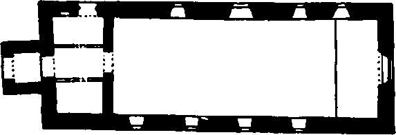
The Church, Plan
The West Porch has a plain outer entrance, with a modern roof-truss, forming the head.
Fittings—Bell: inaccessible but with inscription in capitals, possibly mediæval. Monument: In churchyard—S. of church, to Richard Birkett, parson of the parish, 1699, table-tomb. Panelling: Round walls of church—panelled 17th-century dado. In lobby— moulded panelling, 17th-century. Pulpit: square, with panelled faces in two heights, upper panels with strap-ornament, applied panel with initials and date I. and A.D. 1634. Recess: In N. wall of vestry— square-headed recess. Seating: In nave—twelve late 17th-century benches, with panelled backs and ends. Stoup: square bowl with stop-chamfered angles and shallow sinking, possibly mediæval stoup.
Condition—Good.
Secular
Monuments (2–33)
The following monuments, unless otherwise described, are of the 17th century and of two storeys. The walls are of rubble and the roofs are slate-covered. Some of the buildings have exposed ceiling-beams.
Condition—Good or fairly good, unless noted.
b(2). Hebscrag, house, now outbuilding, 100 yards N. of the old church, retains an original window.
Condition—Poor.
b(3). Wintercrag, house and barn 150 yards S.W. of the old church. The House contains an original panelled spice-cupboard and a fireplace and oven of c. 1700. The Barn, W. of the house, is of seven bays.
b(4). Nicklethorn, house, now outbuilding, 140 yards S.S.W. of (3), has two original windows with wooden mullions.
Condition—Poor.
b(5). Henhow, house and barn 700 yards S. of the old church. The House has remains of a semi-circular staircase at the back. The Barn, S. of the house, is of seven bays.
Condition—Of house, ruined.
b(6). Thrangcrag, house 200 yards S. of (5), has some original moulded ceiling-beams.
b(7). Barn, on the E. side of Boredale 1,080 yards W.S.W. of the old church.
b(8). Nettleslack, house 300 yards W. of (7), has large stone quoins set projecting alternately on the two sides of the angle.
Condition—Poor.
b(9). House, immediately E. of (8), has a byre added in 1742 at the S. end. In the house is an original panelled spice-cupboard.
Condition—Poor.
b(10). Howsteadbrow, house 700 yards W.N.W. of the old church.
b(11). Garth Heads, house 40 yards N.W. of (10), contains a staged cupboard of the local type with a fascia dated 1693 resting on twisted balusters.
b(12). Cothow, house 500 yards N. of the old church, incorporates the lower parts of three crutch-trusses, probably of the 16th century. There is a late 17th-century panelled spice-cupboard.
b(13). House, 250 yards N.N.W. of (12), retains a central roof-truss of crutch-form.
Condition—Poor.
b(14). Hause Farm, house immediately N. of (13), has some original moulded ceiling-beams.
b(15). Hallinbank, house about ½ m. N.N.W. of the old church, contains some original muntin and plank partitions, panelled doors and a spice-cupboard.
b(16). Highgate, house 130 yards S. of (15).
b(17). Bridgend, house at Sandwick 1,200 yards N.W. of the church, retains some original windows and a panelled cupboard of the local type.
b(18). Dawgreen, house 100 yards W. of (17), has been much altered but retains one original panelled cupboard of the local type.
b(19). Mill How, house ¼ m. N.W. of (18).
b(20). Town Head, house 120 yards N.W. of (19), has an addition of 1720 at the N. end.
b(21). Bushby Cottage, 40 yards N.W. of (20), has some original moulded ceiling-beams.
b(22). Beckside, house 40 yards N.E. of (21), contains an original panelled spice-cupboard.
d(23). Barn, S. of Howtown and 1,500 yards N.E. of the old church, has a central truss of crutch-type.
d(24). Cote, house in Fusedale 1,450 yards E.N.E. of the old church, retains an original window and moulded ceiling-beams. There is also a muntin and plank partition of the local type.
d(25). Bank House, N. of Howtown and 1¼ m. N.E. of the old church, bears the modern or re-cut date 1627. It incorporates three re-set crutch-trusses.
d(26). Building, said to have been the old school, 670 yards N.N.E. of (25), is of three bays.
Condition—Poor.
a(27). Bonscale, house 150 yards N. of (26), contains a panelled cupboard of the local type, with the initials and date R. and A.D. 1698; there is also a panelled spice-cupboard of the same period.
a(28). Swarthbeck, house in the N. angle of the parish about 2 m. N.E. of the old church, has a stone panel with the initials and date F.S. 1712, probably indicating a repair.
e(29). Barn in Bannerdale, about 1 m. S. of the old church, is lit by loop-lights.
c(30). Dale Head, house about 1½ m. S. of the old church, has a series of piers on the E. side, formerly supporting a gallery; one of these piers has the date 1666. Some original windows remain on the W. side. Inside the building is a panelled cupboard of the local type, with cock's head hinges, inlaid panels and a fluted frieze.
e(31). House, immediately E. of (30), has been little altered. There are remains of an original plastered hood or flue to the fireplace.
c(32). Boredalehead, house now barn 1¼ m. S.W. of the old church.
c(33). Chapel in the Hause, ruin at the head of Boredale and nearly 2½ m. S.W. of the old church, is now standing at most some 4 ft. high. A doorthreshold remains in the N. wall, but the purpose and date of the building are uncertain.
Condition—Ruined.
Unclassified
c(34). Village Settlement (910 ft. above O.D.) on Heck beck in Upper Bannerdale, covers an area of about 2 acres. The site occupies a slight shelf and slopes downwards on each side of the beck which runs through the settlement. It has very much the usual arrangement of more or less circular huts and irregular enclosures. There are, however, certain points worthy of notice. Firstly towards the N.E. end is an irregular enclosure with exceptionally well-preserved orthostats of unusual size, many of them standing quite 3 ft. above the ground. The enclosure is sub-divided into two main divisions, each with a clearly marked entrance on the E., while the walls, 7–8 ft. in thickness, would appear to be considerably wider than the outer wall or rampart of the part of the village in which it stands, or of the remainder of the work, the walls of which would appear to have varied in width from about 3 ft. to 4½ ft. Secondly, that part of the village lying S. of the beck shows little more than traces of two, or possibly three, huts and a slight trace of an enclosing wall at the S. angle. These points and the general lay-out would seem to suggest a rebuilding and possibly an enlargement of the village on one or possibly two occasions. Unfortunately, the line of the outer wall of the village is entirely missing for much of its length. In addition to those already mentioned, there is a well-marked entrance in the wall of the enclosure immediately S.W. of the subsidiary enclosure. All these entrances are formed with large flat orthostats. There would appear to have been a re-entrant in the outer wall on the N.W. where a natural mound of large outcropping rocks has been incorporated into the wall.
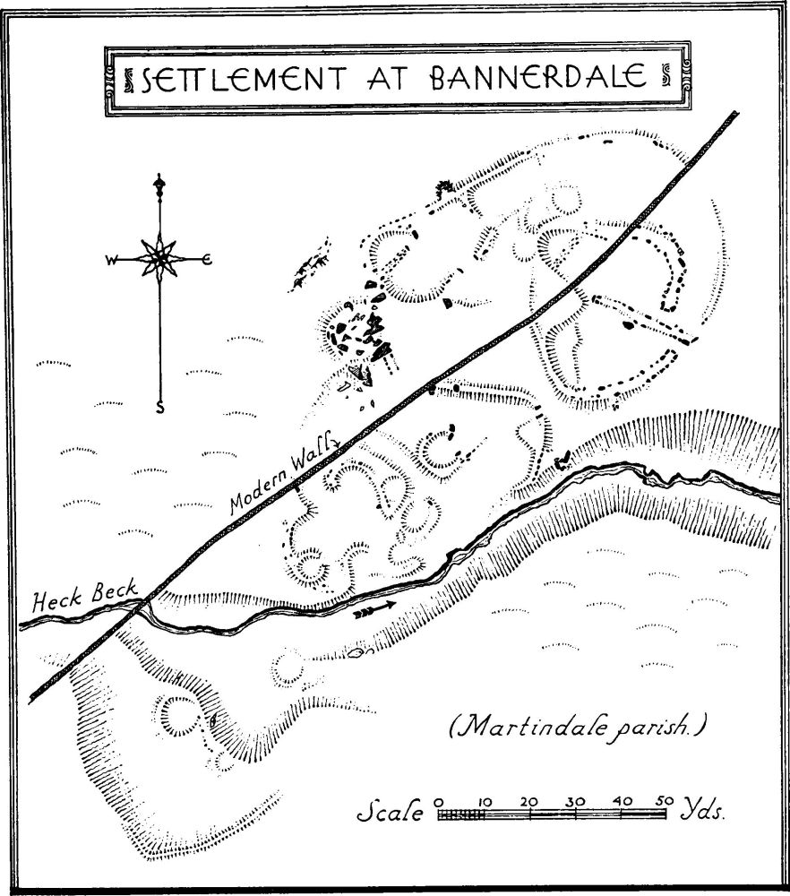
Settlement at Bannerdale
Some 240 yards E.S.E. of the village is a length of isolated dyke and some 200 yards S. of the village are traces of field-walls and a number of stone mounds which may be cairns.
Condition—Bad, except one enclosure.