An Inventory of the Historical Monuments in Westmorland. Originally published by His Majesty's Stationery Office, London, 1936.
This free content was digitised by double rekeying. All rights reserved.
'Ravenstonedale', in An Inventory of the Historical Monuments in Westmorland(London, 1936), British History Online https://www.british-history.ac.uk/rchme/westm/pp197-200 [accessed 30 April 2025].
'Ravenstonedale', in An Inventory of the Historical Monuments in Westmorland(London, 1936), British History Online, accessed April 30, 2025, https://www.british-history.ac.uk/rchme/westm/pp197-200.
"Ravenstonedale". An Inventory of the Historical Monuments in Westmorland. (London, 1936), British History Online. Web. 30 April 2025. https://www.british-history.ac.uk/rchme/westm/pp197-200.
In this section
81 RAVENSTONEDALE (F.e.)
(O.S. 6 in. (a)XXIX, N.E., (b)XXIX, S.E., (c)XXX, N.W., (d)XXX, S.W., (e)XXXV, N.E., (f)XXXV, S.E., (g)XXXVI, N.W.)
Ravenstonedale is a parish and village on the Yorkshire border, 5 m. S.W. of Kirkby Stephen. Tarn House and the Dyke (33) are the principal monuments.
Ecclesiastical
a(1). Parish Church of St. Oswald, stands at the N. end of the village. The tower was re-built in 1738 and the rest of the church in 1744. The building is a good and complete example of its period and incorporates some work from the earlier building. The chancel-arch is at any rate partly of mediæval materials and the responds have 13th-century moulded capitals and part of a moulded base. The N. entrance of the N. porch incorporates mediæval material, and the S. entrance of the S. porch is of the 13th century re-set; it has a two-centred arch of two chamfered orders, the outer continuous and the inner springing from semi-circular shafts with moulded capitals and bases; the arch has a moulded label. The tower-arch is two-centred and may be of mediæval date but is now plastered over. The bell-chamber has two re-set early 16th-century windows, each of three elliptical-headed lights; the S. window has a moulded label; the embattled parapet is perhaps of the same date, re-set.
Fittings—Bells: three; 2nd inscribed in Lombardic capitals "Sce. Michael" with a shield, 15th-century; 3rd by Christopher Hodson, 1694. Churchyard Cross: S. of the tower—shaft (Plate 37) with moulded angles and faces much weathered, possibly pre-Conquest, square base and sundial on top with initials and date I.H. 1700. Coffin-lids: In churchyard—N.E. of church, (a) tapering slab with enriched cross on stepped base; (b) tapering slab with enriched cross on stepped base; (c) tapering slab with enriched cross and chalice; all late 13th or early 14th-century. Door: In vestry doorway—panelled door, 17th-century. Font: probably 18th-century but incorporating mediæval rectangular and chamfered stem. Panelling: In nave— flanking chancel-arch, two panels painted with the Commandments, the Creed and the Lord's Prayer and figures of Moses and Aaron, St. John and St. Peter, N. panel with the date 1747 but panels possibly earlier. Incorporated in seating in nave and gallery, 17th-century panelling, some styles in gallery inscribed with parts of the text "How beautiful [upon the mountains]," etc. Plate: includes a cup (Plate 54) of 1664 with a balusterstem and a flagon of 1706 given by George Fothergill in 1743. Miscellanea: In tower—stone corbel with 'beak-head' ornament, 12th-century. Incorporated in pulpit and stairs to gallery—17th-century turned balusters.
Condition—Rebuilt.
Secular
a(2). Ruins and foundations, immediately N. of the church, are presumably those of a small establishment or cell of the Gilbertine Canons of Watton (Yorks) to whom the vill of Ravenstonedale was given probably late in the 12th century. To them also belonged the rectory of the church. The remains stand in places to a height of 5 or 6 ft. and the foundations were excavated in 1927–8 (C. and W. Trans. N.S. XXIX and XXX). The main range adjoined the church and had a wing projecting to the E. The excavations indicated that there were other wings projecting to the W. and E. at the N. end of the main range. The walls are all of local rubble. The S.E. wing was perhaps the earliest part of the structure; it has remains of a fireplace and doorway in the N. wall and a garde-robe at the E. end. The main range had a small porch, with a staircase to the upper floor, on the E. side, and remains of a window and doorway in the W. wall. The general arrangements are shown on the plan and the remains appear to date from the 14th or 15th century. Machell, writing in 1681, says that the building formed a quadrangle on the N. of the church and that the rooms had vaulted undercrofts.

Ravenstonedale, Mediaeval Foundations North of the Church
Condition—Ruined.
d(3). Tarn House, about 1¾ m. E.S.E. of the church, is of two storeys; the walls are of rubble and the roofs are slate-covered. The house was built in 1664 by George Fothergill and has been little altered except for the addition of a modern E. porch. The S. front (Plate 20) retains its original stone-mullioned windows with moulded labels; the lower labels are continued along the front and finish in long stops with scroll-ornament. The two-storeyed porch has an outer archway with moulded jambs and four-centred arch in a square head; on the plinth flanking it are scroll-ornaments. Above the archway is a long panel with the initials and date G.F. and I.F. (for George and Julia Fothergill) 1664 and various enrichments. Higher up is a rectangular panel with five shields-of-arms, (a) Fothergill, (b) Scrope, (c) Dent, (d) Brand and (e) Skelton; the opening to the upper room of the porch is modern but retains its old label. In the E. wall are two windows with re-used trefoiled heads of mediæval date. Some original windows and a doorway remain at the back of the house. Inside the building are some original panelled doors and doorways; two of the doorways have enriched heads. The room in the back wing has a panelled partition with an enriched frieze; in the partition is a two-stage cupboard of the local type, with projecting fascia and pendants.
Condition—Good.
Monuments (4–31)
The following monuments, unless otherwise described, are of the 17th century and of two storeys; the walls are of rubble and the roofs are slate-covered. Some of the buildings have exposed ceiling-beams.
Condition—Good or fairly good, unless noted.
a(4). House, on the S. side of the road 230 yards W.N.W. of the church, was built late in the 17th or early in the 18th century.
d(5). Cottage, on the S. side of the road 250 yards S.S.E. of the church, has a later addition at the N.E. end, with a stone staircase set in a projection; adjoining it is a re-set 16th-century window with an elliptical head.
d(6). Ash Fell, outbuilding, formerly house, 1,480 yards E. of the church, retains some original windows with a continuous label.
d(7). Bleaflath, house 370 yards S.S.E. of (6), is modern except for the late 17th or early 18th-century back wing.
d(8). Lockholme, house about 1 m. S.E. of the church, was built late in the 17th or early in the 18th century.
d(9). Lockholme Hall, 200 yards S.E. of (8), has been much altered but has a re-set doorway with the initials and date H.F. 1697 above the lintel. Inside the building is a small length of original panelling.
d(10). Artlegarth, house ½ m. W.S.W. of (9), has a later addition on the S.
Condition—Ruinous.
g(11). House at High Dovengill, about 3 m. S. of the church, retains some original stone windows.
Condition—Ruined.
g(12). House, 30 yards W. of (11) retains some original stone windows and a doorway with a segmental head.
Condition—Ruined.
g(13). Elm Pot, house 250 yards S. of (12), was built early in the 18th century.
g(14). Streetside, house ¼ m. S.S.W. of (13), retains some original stone windows. A doorway on the W. side has the date 1714. Inside the building are two original panelled partitions.
e(15). Low Sprintgill, house ¼ m. W. of (12).
e(16). High Sprintgill, house 200 yards S.W. of (15), contains a two-stage cupboard and a spice-cupboard, both with panelled doors. A large original fireplace has a segmental arch.
e(17). House at Murthwaite 3½ m. S. of the church, was built probably early in the 18th century, and has a fireplace with a corbelled head, dated 1780.
e(18). House, 30 yards N.W. of (17), was built early in the 18th century and has a re-set door-lintel with the initials and date A. and F.I. 1710.
e(19). Bridge, house 630 yards S.E. of (18), retains an original window, formerly of three lights.
e(20). Wraygreen, house 300 yards S.S.E. of (19), retains some original windows, partly blocked; above the lower range is a continuous label with scrolled ends. Inside the building is a three-stage cupboard of the local type, with enriched upper panels, turned posts and fascia with the initials and date R.A., W.P. 1644, possibly added. There is also a panelled partition.
f(21). Tarn, house nearly 4¼ m. S. of the church and 160 yards S.S.E. of (20).
b(22). Cow Bank, house nearly 2¼ m. W.S.W. of the church, was built probably early in the 18th century and contains a cupboard of the local type with enriched upper panels, pendants and fascia with the initials and date A.A. 1702.
a(23). House at Bowderdale, 2¾ m. W. of the church, contains some original panelling.
a(24). Rigg End, house about 2¼ m. W.N.W. of the church, was built late in the 17th or early in the 18th century.
a(25). High Dubbs, house 570 yards E.S.E. of (24), is of the same period and contains some 17th-century panelling.
a(26). House on the S. side of the road at Low Lane 590 yards E. of (25), has a re-set door-lintel with the initials and date A.P. 1684. A second lintel set in a garden-wall has the initials and date T.S. 1686. Inside the house is some original panelling.
a(27). House, 130 yards E. of (26), has a panel with the initials and date I.F. 1679 in the N. wall.
a(28). Sandwath, house 1¼ m. W.N.W. of the church, has been much enlarged in 1830.
a(29). White House, on the N. side of the road at Newbiggin 570 yards N.E. of (28), was built early in the 18th century.
a(30). Tower House, on the N. side of the road at Brownber nearly 1½ m. N.W. of the church, has been heightened. It retains some original windows and the door-lintel has the initials T. and F.A. Inside the building is a three-stage cupboard with enriched upper panels, pendants and fascia. There is some re-set original panelling.
a(31). Friar Bottom, house 600 yards E. of (30), contains a three-stage cupboard with enriched upper panels, pendants and fascia with the initials and date E. and E.W. 1652.
a and c(32). Ravenstonedale Park, on either side of the Scandal beck on the N. border of the parish, was enclosed as a deer-park by the first Lord Wharton in 1560. It was surrounded by a stone wall still in part standing to a height of 9 ft. The E. and part of the S. boundary can still be clearly traced and the whole enclosure can be readily traced by the comparatively small field-enclosures immediately outside its limits. The area enclosed is about 520 acres and the perimeter rather over 3 m. These dimensions however do not agree with the recorded area and perimeter of the park (C. and W. Trans. N.S. I, p. 400), which are smaller.
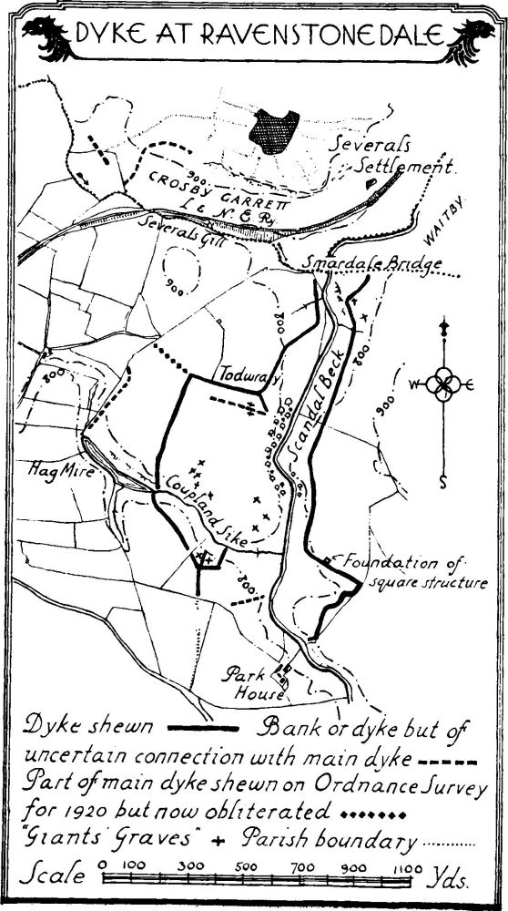
Dyke at Ravenstonedale
Unclassified
a(33). Dyke and mounds on either side of the Scandal beck and wholly within the area of (32). The course of the dyke with its branches is shown on the accompanying plan; it enclosed an area of at least 100 acres. The main dyke averages about 15 ft. in width and 4 ft. high with traces of a spoil-ditch in places. An isolated portion of dyke N. of Severals gill in Crosby Garrett (8) may have formed a connection with this work. Built against the outside of the dyke on the E. side, are the foundations of a rectangular structure 15 by 13 yards. Within the area are twelve mounds of the pillow-mound type mostly with traces of an encircling ditch; they are of nearly uniform size about 51 ft. by 18 ft. Immediately outside the enclosure on the N.E. are two further and similar mounds. These mounds are called Giants' Graves and the neighbouring group is described under Waitby.
Condition—Of dyke, mostly good.
c(34). Enclosures, 270 yards E. of Ashfield and 1,600 yards E. of the church, consist of slight traces of wall-foundations of rectangular structures or enclosures (C. and W. Trans. N.S. XXX, p. 222), possibly of no great age.
a(35). Mound at Hard Rigg, 1 m. W.N.W. of Ravenstonedale station, was examined by Greenwell (Brit. Barrows CLXXVII) and found to contain an urn with the burnt remains of a woman; among the bones was a clay bead. The mound is not now visible but is marked on the O.S.
a(36). Cairn, about ¼ m. N. of (35), is much overgrown. It was about 27 ft. in diameter and 2 ft. high.
a(37). Lynchets, by Chapel Rigg 1 m. N.W. of the church, on a S. slope, are fragmentary. They are about 80 yards long and 8 yards wide.
a(38). Lynchets, immediately S.W. of Smardale bridge, on an E. slope, are about 60 yards long and 4½ yards wide.