A History of the County of Sussex: Volume 6 Part 3, Bramber Rape (North-Eastern Part) Including Crawley New Town. Originally published by Victoria County History, London, 1987.
This free content was digitised by double rekeying. All rights reserved.
A P Baggs, C R J Currie, C R Elrington, S M Keeling, A M Rowland, 'Crawley New Town', in A History of the County of Sussex: Volume 6 Part 3, Bramber Rape (North-Eastern Part) Including Crawley New Town, ed. T P Hudson (London, 1987), British History Online https://www.british-history.ac.uk/vch/sussex/vol6/pt3/pp74-75 [accessed 6 May 2025].
A P Baggs, C R J Currie, C R Elrington, S M Keeling, A M Rowland, 'Crawley New Town', in A History of the County of Sussex: Volume 6 Part 3, Bramber Rape (North-Eastern Part) Including Crawley New Town. Edited by T P Hudson (London, 1987), British History Online, accessed May 6, 2025, https://www.british-history.ac.uk/vch/sussex/vol6/pt3/pp74-75.
A P Baggs, C R J Currie, C R Elrington, S M Keeling, A M Rowland. "Crawley New Town". A History of the County of Sussex: Volume 6 Part 3, Bramber Rape (North-Eastern Part) Including Crawley New Town. Ed. T P Hudson (London, 1987), British History Online. Web. 6 May 2025. https://www.british-history.ac.uk/vch/sussex/vol6/pt3/pp74-75.
CRAWLEY NEW TOWN
CRAWLEY (fn. 1) was one of the six original new towns designated under the New Towns Act, 1946, as part of the planning of the London region after the Second World War. The Dalton committee agreed to select Crawley in May 1946, before the Act was passed, to avoid the need for a new housing estate at Chessington (Surr.). (fn. 2) Also in 1946 Dr. Thomas Sharp was appointed to make a survey and prepare an outline plan. (fn. 3) An area of 5,920 a. was formally designated the following January under the Crawley New Town (Designation) Order, 1947. (fn. 4)
The area was divided among the three administrative counties of East and West Sussex and Surrey, the three corresponding rural districts of Cuckfield, Horsham, and Dorking and Horley, and the five civil parishes of Slaugham, Worth, Crawley (including Ifield), Lower Beeding, and Charlwood (Surr.). An order of 1953 transferred 3,347 a. of Slaugham and Worth in Cuckfield rural district to West Sussex and to Crawley parish. In 1956 the parish, then the most populous mere civil parish in England, became an urban district; at the same time 136 a. were transferred to Lower Beeding and 2,114 a. to Rusper. The urban district thus covered 5,614 a.; it excluded the East Sussex and Surrey parts of the new town. (fn. 5) The urban district became a borough in 1974, when the remaining parts of the new town area in Worth and Slaugham and Gatwick airport in Surrey were included in it. (fn. 6) In 1983 boundary changes included in the borough Hyde Drive (formerly in Rusper) and part of Bewbush (formerly in Lower Beeding) on the west, and the Wakehams Green area (formerly in Worth) on the east, a total area of 1,800 a. The borough thereby covered 10,767 a. (fn. 7)
The designation order of 1947 was challenged in the courts and was not finally confirmed until December 1947, delaying the start of development. A development corporation was appointed in February 1947 with Sir Thomas Bennett, a London architect, as chairman. (fn. 8) Bennett quarrelled with Sharp over his draft master plan; Sharp resigned, and Anthony Minoprio was appointed planning consultant. (fn. 9) His draft plan was published in December 1947 at a meeting in Crawley of local authority representatives and others. (fn. 10) The master plan was finished in 1949 (fn. 11) and approved by the government in 1950. (fn. 12) Meanwhile the corporation began work on main services, (fn. 13) and commissioned detailed surveys to reveal the character of the area and the age and structure of its population. (fn. 14)
The development corporation continued to be responsible for the planning and most of the building of the new town. It proceeded rapidly with its tasks, in great measure owing to the enthusiasm and energy of Bennett, who left his stamp on the town (fn. 15) and by paying close attention to public relations could the more easily resolve disputes with the inhabitants and local authorities. (fn. 16) He was ably assisted by Col. C. A. C. Turner, the corporation's chief executive 1947-59. (fn. 17) When Bennett resigned in 1960 the corporation had already met most of the growth targets originally expected to take 15 years. (fn. 18) It was therefore dissolved in 1962, its property and some of its powers passing to the Commission for the New Towns established under the New Towns Act, 1959, (fn. 19) instead of to the local authority as originally intended in the 1940s. (fn. 20) The commission lacked the planning and purchasing powers of development corporations (fn. 21) and proved less able to moderate the effects of changes in government policy, which were marked on housing, (fn. 22) social amenities, (fn. 23) and, as a result of the growth of Gatwick airport, on the town's economy. (fn. 24) Successive governments gradually reduced the commission's powers, particularly over housing. (fn. 25) From 1978 it was responsible only for two shopping centres and for industrial sites, and all those assets were being sold off to private interests in the 1980s. (fn. 26)
Crawley Development Corporation.
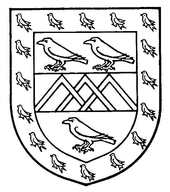
Or, on a fesse gules between three crows sable, three chevronels interlaced argent, all within a bordure azure charged with sixteen martles or. [Granted 1951]
The new town was originally intended to accommodate 40,000 people. (fn. 27) The master plan allowed for expansion up to 50,000, (fn. 28) and in 1950 the minister of town and country planning urged that the target should be 60,000; that was successfully resisted by the development corporation. (fn. 29) In 1956 a limit of 55,000 was regarded as appropriate. (fn. 30) Draft plans of 1961 expected further growth to 70,000 by 1980. (fn. 31) By 1969 it was recognized that such a limit would require 'a virtual ban on the free movement of people to Crawley', and the possibility of growth up to 120,000 was considered. (fn. 32) The population in 1951 of the area later included in Crawley urban district was 10,481. In 1961 it was 53,768, the increase being more than half that of all West Sussex, and in 1971 it was 67,608. The population of the designated area was 54,047 in 1961, 67,843 in 1971, and 72,684 in 1981. The borough in 1981 had 73,376 people; a further 7,874 were normally resident in the new neighbourhoods then outside the borough but included in it in 1983. (fn. 33)
Elizabeth II visited the new town as duchess of Edinburgh in 1950 (fn. 34) and as queen in 1958 and 1969. (fn. 35) The town also attracted many official parties of visitors from all over the world: in 1958 there were 2,001 visitors from 48 countries, (fn. 36) in 1961 over 3,400 in 289 groups from 67 countries, (fn. 37) and in 1963 over 3,000 in 240 groups from 85 countries. (fn. 38)