A History of the County of Middlesex: Volume 5, Hendon, Kingsbury, Great Stanmore, Little Stanmore, Edmonton Enfield, Monken Hadley, South Mimms, Tottenham. Originally published by Victoria County History, London, 1976.
This free content was digitised by double rekeying. All rights reserved.
'Great Stanmore: Introduction', in A History of the County of Middlesex: Volume 5, Hendon, Kingsbury, Great Stanmore, Little Stanmore, Edmonton Enfield, Monken Hadley, South Mimms, Tottenham, (London, 1976) pp. 88-96. British History Online https://www.british-history.ac.uk/vch/middx/vol5/pp88-96 [accessed 8 May 2024]
GREAT STANMORE
Great Stanmore (fn. 1) was a parish of 1,441 a. in 1841. (fn. 2) It was roughly the shape of an elongated rectangle, running from north-north-west to south-south-east, and the village at its centre lay some 10 miles from London. (fn. 3) Stanmore was divided before the Conquest into estates foreshadowing the later parishes of Great and Little Stanmore, (fn. 4) although the name of Great Stanmore does not occur until 1354. (fn. 5) Throughout its history the main settlement, to which there was no equivalent in Little Stanmore, was often called merely Stanmore, (fn. 6) as were the old village and its surrounding district in 1971.
The parish was delimited by few natural features or roads. (fn. 7) Its northern boundary crossed Bushey Heath, where the limits of the manors of Great Stanmore and Bushey were surveyed in 1595, and became that of the county. (fn. 8) The inclusion of Stanmore marsh was not finally determined, by agreement with Little Stanmore, until the 1820s. (fn. 9) After that time the eastern boundary, running from Hertfordshire along the west side of Cloisters wood to the bottom of Dennis Lane, continued south down Marsh Lane (fn. 10) and bulged outwards at Stanmore marsh before heading almost as far south as the site of Queensbury station. The southern boundary, with Harrow, ran for a short way along Honeypot Lane before turning west a little to the south of the modern Streatfield Road. The western boundary, also with Harrow, was later marked by a line slightly east of Uppingham Avenue, curving north-west towards Vernon Drive. Thence it crossed Belmont, a mound constructed by James Brydges, duke of Chandos (d. 1744), (fn. 11) Stanmore Park, the Uxbridge road, and the grounds of Bentley Priory, east of the mansion, to reach Hertfordshire where Magpie Hall Road meets Heathbourne Road. Great Stanmore civil parish was included in Hendon R.D. from 1894 until 1934. Thereafter most of both Great and Little Stanmore lay within the ward of Stanmore North, which formed part successively of the urban district, borough, and London Borough of Harrow. (fn. 12)
The soil is predominantly London Clay. A band of pebble gravel fringed by Claygate Beds crosses the parish along a high ridge in the north, stretching from Wood Lane over the southern part of Stanmore Common and into the grounds of Bentley Priory. (fn. 13) One of the ponds on the gravel, possibly Spring pond, may have been the 'stony mere' which gave its name to the locality. (fn. 14) A narrow strip of alluvium lies along the boundary north of Stanmore marsh. (fn. 15)
The main contours run from east to west. Apart from Belmont the southern half is almost flat, rising from less than 200 ft. very gradually to reach 300 ft. about 150 yards above the foot of Stanmore Hill. From that point the ground rises steeply to 475 ft. at the southern edge of the common and in the northwest, although it falls away to 350 ft. in the northeastern corner, which is drained towards Aldenham reservoir (Herts.). The Stanburn stream flows from the lake of Bentley Priory in Harrow south-eastward, past Boot pond and through Temple pond, to the southern end of Stanmore marsh; there, as Edgware brook, it turns south to follow the boundary before a second turn leads it eastward across Little Stanmore. (fn. 16) Spring pond, on the southern edge of the common, was probably the 'great pond' from which water was taken down Stanmore Hill by 1640. (fn. 17)
John Warner (d. 1565), physician, and William Wigan Harvey (1810-83), divine, son of George Daniel Harvey of Montagues, were natives of the parish. (fn. 18) General Robert Burne died in retirement at Berkeley Cottage, Stanmore, in 1825. Charles Hart (d. 1683), Baptist Wriothesley Noel (1798-1873), divine, and Arthur Hamilton-Gordon (1829-1912), colonial governor, were also resident. In 1893 the last was created Lord Stanmore of Great Stanmore, (fn. 19) a title which became extinct in 1957. (fn. 20) Other prominent residents are mentioned elsewhere in this article, where their homes are described.
In the Middle Ages the busiest road was that running from Watling Street to Watford, mentioned c. 1170. (fn. 21) The section which entered from Little Stanmore, probably near the crest of the ridge at Spring pond was rendered useless in the early 18th-century by the duke of Chandos's diversions around Canons (fn. 22) but the north-western stretch was left to follow the old route along the edge of Stanmore Common and into Harrow parish. (fn. 23) At the bottom of the ridge a lesser route cut south-westward through the parish, linking Watling Street with Harrow Weald and Uxbridge. (fn. 24) It followed the line of the modern Broadway and Church Road, continuing between the sites of the existing church and the rectory along Colliers Lane (fn. 25) before that stretch was foreshortened by the building of Stanmore Park; later Uxbridge Road, a 'new' road in 1800, (fn. 26) was laid out with its bulge to the north. Across it ran two ways from the high ground: Dennis Lane, which joined it at the boundary and continued south as Marsh Lane and Honeypot Lane, and Green Lane. The second continued south as Old Church Lane, before turning east to meet Marsh Lane, and as Watery Lane, which itself turned to join Honeypot Lane. Dennis Lane, so called by 1578, (fn. 27) and its southerly extensions may mark a north to south trackway older than Watling Street; (fn. 28) the route along Green and Old Church lanes, mentioned respectively in 1580 and 1633, (fn. 29) led to the main medieval settlement.
The road called Stanmore Hill, reaching the Uxbridge road between Dennis Lane and Green Lane, may have started as a branch from Green Lane, which it meets half-way up the slope; since the 18th century, however, Stanmore Hill has also been the name for the old stretch between that fork and the top of the ridge. Following the duke of Chandos's building around Canons, most travellers from Watford descended Stanmore Hill before meeting those coming from Uxbridge. East of the junction, at the bottom of Dennis Lane, they could reach Watling Street by taking the new London road straight across Little Stanmore or by going south down Marsh Lane before turning into Whitchurch Lane. (fn. 30) Marsh Lane became important only in the 1930s, when improvements there and along the decayed Honeypot Lane (fn. 31) allowed traffic to head south along a course parallel to Watling Street. Gordon Avenue, running westward to link Old Church Lane with Kenton Lane in Harrow, was laid out after Frederick Gordon bought the Bentley Priory estate in 1882. (fn. 32) The network of residential roads covering the south part of the parish (fn. 33) was constructed between the World Wars.
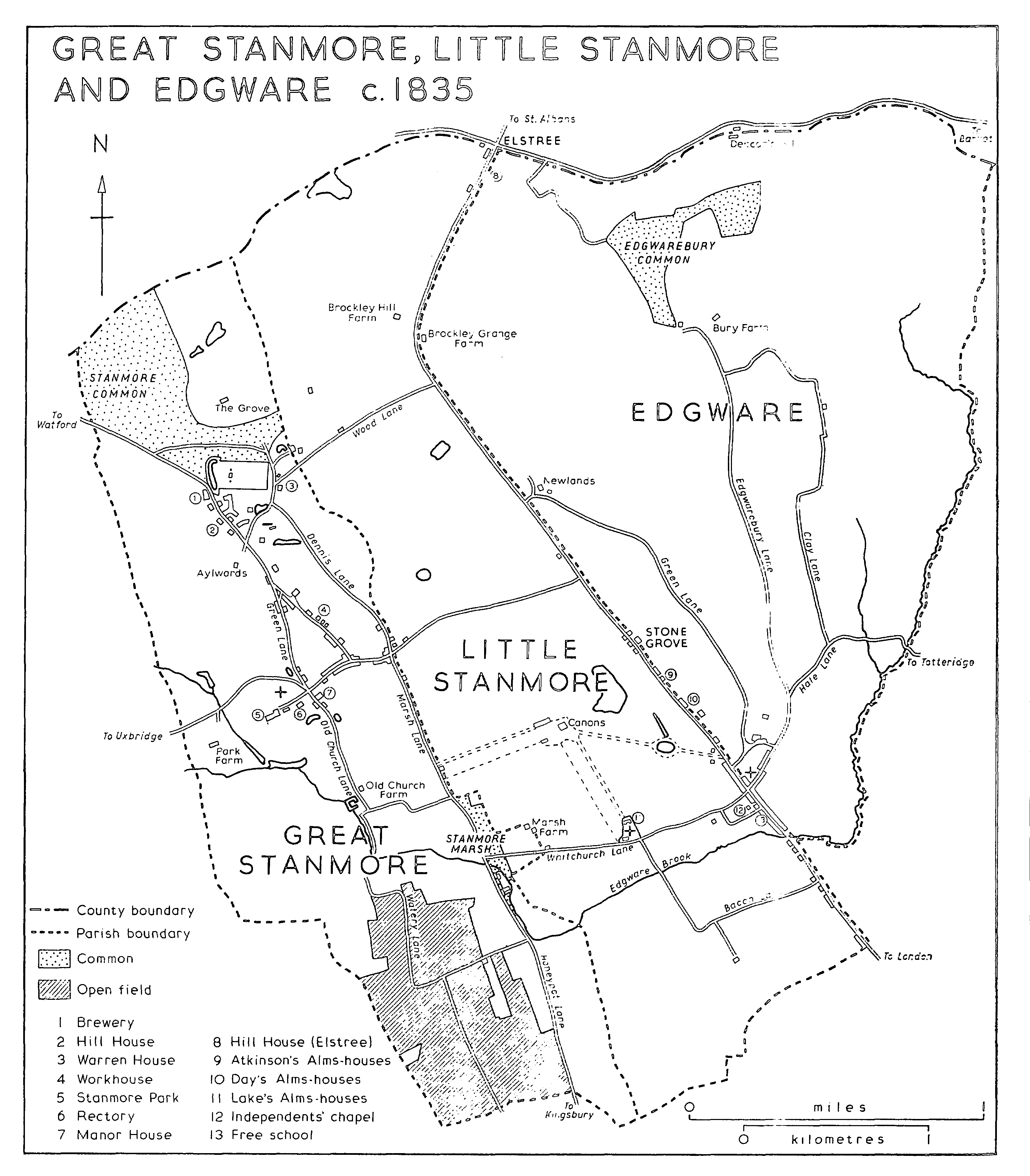
GREAT STANMORE, LITTLE STANMORE AND EDGWARE c. 1835
The Stanburn flowed through a culvert under the Uxbridge road, west of the parish church, in 1826. There were also said to be two footbridges at Stanmore marsh, (fn. 34) although one was probably farther west, where Watery Lane crossed the stream in 1865. (fn. 35) It may have been the stone bridge mentioned in 1576 and the bridge leading from Stanmore town to the marsh which needed repair in 1639. A bridge at the marsh itself had disappeared by 1699, when the lord was asked to put up another. (fn. 36)
Coaches ran between Stanmore and Holborn as early as 1803 (fn. 37) and a coach for Oxford Street left twice daily from the Abercorn Arms on Stanmore Hill by 1826. (fn. 38) Conveyances ran thrice daily from there to London in 1845, when there were also coaches to Chesham (Bucks.), Watford, Rickmansworth, and Hemel Hempstead (Herts.), and when the London coach from Bushey called twice a day at the Vine. (fn. 39) In 1905 it was planned to extend the tramway from Edgware through Great Stanmore as far as Watford but the route was taken only a little farther along Edgware Road. (fn. 40) The London General Omnibus Co. introduced a Sunday motor-bus service from Charing Cross to Harrow Weald through Stanmore village in 1912 and ran motor-buses from Kilburn to Watford through Stanmore from 1913. (fn. 41) By 1925 motor-buses linking Mill Hill and Edgware with Stanmore and Harrow crossed the parish from east to west. While services continued along the old routes, buses were using Marsh Lane and Whitchurch Lane (fn. 42) by 1934 and were afterwards introduced into the south part of the parish, along the new Wemborough Road and Honeypot Lane. (fn. 43)
The nearest railway stations were at Harrow (later Harrow and Wealdstone) and at Edgware until 1890, (fn. 44) when the Harrow and Stanmore Railway Co. opened a branch line from the L. & N.W.R. main line station at Harrow. The company, which had been incorporated in 1886, was controlled by Frederick Gordon of Bentley Priory. It tried to placate the parish council by building the red-brick Stanmore railway station, on the west side of Old Church Lane, in an ecclesiastical style and by promising that there should be no Sunday service for 40 years. Under an Act of 1899 the L. & N.W.R. took over the working of the new line, on which an intermediate station was opened at Belmont, on the Harrow side of the boundary, in 1932. Thirty-six trains ran each way on weekdays along the entire length in 1952, when the section between Belmont and Stanmore was closed. (fn. 45) Since that date the nearest station to the old village has been the Stanmore terminus of the Bakerloo line, in Little Stanmore. (fn. 46)
Settlement in the Middle Ages presumably centred upon the manor-house, at the corner of the later Wolverton Road and Old Church Lane, and the church which stood a few yards north of it. (fn. 47) It is not certain whether, as in Kingsbury, (fn. 48) the Black Death played a part in the decay of the old village and the choice of a more northerly site. (fn. 49) Increasing traffic may have made the route to Uxbridge more attractive than a position ¼ mile down a branch road such as Old Church Lane. The sites of head tenements, though not recorded until the late 16th century, (fn. 50) suggest that many medieval holdings were scattered well to the north of the manor-house: Montagues lay on the south side of the road to Uxbridge, Fiddles nearly opposite at the west corner of Dennis Lane, (fn. 51) Pynnacles at the east corner of Green Lane, and Aylwards higher up, off the west of Stanmore Hill. (fn. 52)
A northward shift in the centre of population may explain why, by 1582, the three common fields were known as Hither, Middle, and Further fields. (fn. 53) Lying either side of Old Church Lane and stretching beyond, around Watery Lane, to the Kingsbury boundary, they surrounded the old village but were all south of the houses along the way to Uxbridge. (fn. 54) The fields adjoined those of Harrow Weald to the west and of Kenton farther south, from which holders had been ordered to separate them by hedges and ditches before 1579, when boundary stones were planned. (fn. 55) On the eve of inclosure in 1839, under an Act of 1813, the fields were confined to one corner of the parish, south of the Stanburn and west of Honeypot Lane; they straddled Watery Lane and, with the roadway, covered no more than 308 a. (fn. 56)
East of the common fields and astride the illdefined parish boundary lay Stanmore marsh, where in 1582 the homage of Great Stanmore admitted that certain tenants of Little Stanmore also had pasture 'of right immemorial'. A cottage recently built there was ordered to be taken down, as an encroachment, in 1679, and in 1680 Sir Lancelot Lake of Canons was presented for having inclosed part of the marsh some twenty years previously. (fn. 57) By 1838 the marsh consisted of a narrow strip along the east side of Marsh Lane, stretching from a point opposite Old Church Lane to a few yards south of Whitchurch Lane. (fn. 58) A shortened strip of some 10 a. by the corner of Whitchurch Lane constituted the open space called Stanmore marsh in 1972. (fn. 59)
Most of the waste lay in the north-west part of the parish. It was originally considered part of Bushey Heath (fn. 60) but was known by 1637 as Stanmore heath and later as Stanmore Common. Five cottages there were condemned as encroachments in 1679. (fn. 61) Stanmore Common in 1838 stretched half-way along the Hertfordshire boundary and south to the Watford road and the reservoir, with an arm reaching almost to the eastern boundary south of the Grove. Below the reservoir was Little Common, probably the site of the 17th-century encroachments and with many more cottages 150 years later. (fn. 62) Stanmore Common covered the same area, 120 a., in 1838 as in 1972, (fn. 63) when Hadley Common was the only comparable uninclosed space in what had been north-west Middlesex. (fn. 64)
By 1754, after the rerouting of traffic to Watford, settlement was concentrated along the Uxbridge road, along Stanmore Hill and, at the top, around Little Common. (fn. 65) The presumed medieval village was marked only by the moat of the manor-house and, on the opposite side of Old Church Lane, by Old Church Farm. Fields stretched around, with no other houses south of the Uxbridge road save a summerhouse at Belmont. (fn. 66) The new manor-house, the Rectory, the church, which had been moved to a new site in 1632, and other dwellings stood around the intersection of Old Church and Green lanes with the Uxbridge road; to the west Stanmore Park may already have been built on the site of an older residence. Houses were close together on both sides of Church Road near the foot of Stanmore Hill, with others on the lower part of the hill itself. A small group at the corner of Dennis Lane and the London road, although it lay within Little Stanmore, also formed part of the village. More buildings clustered at the top of the triangle formed by Green Lane, Church Road, and Stanmore Hill. Others, including the brewery, (fn. 67) were dotted along the road towards the crest of the ridge and at Little Common. There were buildings on or near the later sites of Warren House and Aylwards but none farther north than the bowling green, (fn. 68) which separated Little Common from the main expanse of heath and thereby may have given Little Common its name. Forty years earlier Bowling Green House had stood there but it was probably replaced by a banqueting house built for the duke of Chandos (d. 1744). (fn. 69)
An inn called the Queen's Head existed by 1714, (fn. 70) and the King's Head, formerly the Three Pigeons, stood in 1730 on Stanmore Hill. (fn. 71) The Queen's Head, the Red Lion on Stanmore Hill, and the Vine on Stanmore Common were licensed by 1751. (fn. 72) The first stood on the corner of the hill and Church Road in 1888, when it was no longer an inn; the Red Lion was last mentioned in 1860. (fn. 73) The Abercorn Arms on the hill, the Crown in the later Church Road, and the Vine were licensed in 1803. (fn. 74) It was at the Abercorn Arms that the Prince Regent met Louis XVIII of France in 1814, after the king had ended his years of exile at Hartwell (Bucks.). (fn. 75) All three of the inns recorded in 1803 survived in 1971, although the Abercorn Arms, still so called in 1863, had been temporarily renamed the Royal hotel by 1865. (fn. 76) Two beer-sellers living on Stanmore Hill in 1851 presumably occupied the Black Horse, recorded between that date and 1879, by which time its name had changed, and the Load of Hay, which comprised three former cottages in 1868. A beer-seller at Stanmore marsh in 1851 perhaps ran the Green Man beershop, so named in 1865. (fn. 77)
Housing spread little in the late 18th and early 19th centuries, (fn. 78) although the village became a more important centre, with a workhouse on the east side of Stanmore Hill from 1788 and probably a separate school-house from c. 1826. By 1865, after the workhouse had been closed, an infants' school stood higher up the slope and a National school near the bottom of the hill. A post office adjoined a smithy slightly higher up than the infants' school, on the western side. Buildings were close together only where some had stood a hundred years earlier: towards the eastern end of the later Church Road, up Stanmore Hill, at the fork between the hill and Green Lane, and on island sites between the Watford road and Spring pond on Little Common. There were gaps along the hill between the National school and the old workhouse, between the infants' school and the Royal hotel, and opposite the infants' school. Buildings at the cross-roads formed by Dennis and Marsh lanes and the London road included a farm (fn. 79) in the south-west corner. Green Lane had no houses between Pynnacles, at its southern end, and a group of over a dozen small dwellings near its junction with Stanmore Hill.
East of the houses lining Stanmore Hill, Dennis Lane in 1865 sloped upwards between fields and, near the top, between the grounds of Stanmore Hall and Warren House. West of the village stretched part of the estate of Bentley Priory, with that of Stanmore Park, including Park farm, south of the Uxbridge road. The flat southern half of the parish was mainly grassland, purchased by St. Bartholomew's hospital. Labourers inhabited the decaying Old Church Farm, whose tenant lived at what had been Ward's Farm at the corner of Marsh Lane. Belmont Terrace, an isolated row of six cottages, had been built since 1827 west of the junction of Watery Lane with Honeypot Lane; (fn. 80) at Stanmore marsh, in addition to the Green Man, there was a group of cottages, numbering four in 1838, (fn. 81) and a recently erected gas-works. The northernmost part of the parish, too, was empty, being divided between Stanmore Common and the estate in the north-east belonging to the Grove. To the north-west some large houses along Heathbourne Road included one, Stanmore Villa, just within the parish boundary.
The most striking change between 1754 and 1865 was the building or enlargement of several gentlemen's residences. In addition to Stanmore Park and the manor-house, near the church, the village contained the head tenements of Montagues, Fiddles, Pynnacles, and Aylwards, (fn. 82) all of which were marked in 1827 by substantial houses. Oak Villa, Townsend Villa (later Belmont Lodge), Rose Cottage, and Vine Cottage formed an extension of the village, into Little Stanmore, at the corner of Dennis Lane and the London Road. Near the crest of the hill, on the west, Hill House and Broomfield stood between the drive leading to Aylwards and the residence next to the brewery. It was at Hill House, then called the Great House, (fn. 83) that Dr. Samuel Parr had briefly opened his school in 1771 and that the antiquary Charles Drury Edward Fortnum, who bequeathed most of his treasures to the Ashmolean Museum, Oxford, lived from 1852 until 1899. (fn. 84) Broomfield, later Broomfield House, was designed c. 1860 by James Knowles. (fn. 85) On the opposite side of the road, south of the corner with Wood Lane, a house erected by the duke of Chandos (d. 1744) had been enlarged in the late 18th-century by James Forbes of the East India Company, who had adorned the grounds with the first pieces of Hindu sculpture to be seen in England. (fn. 86) The mansion itself had been rebuilt, as Stanmore Hall, in 1847. (fn. 87) Forbes had also owned Warren House, farther east along Wood Lane, which he sold in 1813. (fn. 88) By 1827 it had passed to the architect Robert Smirke, who held it with 23 a. in Great Stanmore and 108 a. in Little Stanmore in 1838. (fn. 89) Almost opposite Warren House a drive led northeast to the Limes, which had been built by 1851 on the Little Stanmore side of the border. (fn. 90) Beyond Little Common the banqueting house attributed to Chandos had been the seat of George Hemming in 1795 and of his widow in 1816; (fn. 91) it had recently been pulled down in 1820. (fn. 92) Farther north stood the Grove, where a Jew named Aaron Cappadoce had died in 1782; a grotto and other embellishments made by his successor, one Fierville, were to survive a remodelling of the mansion in the 1870s. (fn. 93) Spacious grounds in many places restricted the spread of humbler housing: in 1865 the gardens of the manorhouse and Pynnacles stretched along the western end of Church Road, and those of Aylwards and Stanmore Hall separated the main village from the settlement around Little Common. The rich owners of such houses, led by Col. Hamilton ToveyTennent of Pynnacles (fn. 94) and encouraged by the Hamilton-Gordons and Queen Adelaide of Bentley Priory, had been responsible for abandoning the 17th-century church in favour of a larger one, consecrated in 1850.
The parish as a whole changed little between the mid-19th-century and the First World War. Stanmore village, considered attractive because it was situated on a slope and bordered by much fine parkland, retained the genteel character for which it was noted in 1876. (fn. 95) William Morris in 1888 found it 'pretty after a fashion, very well wooded . . . but much beset with "gentlemen's houses". Nothing but grass fields everywhere'. (fn. 96) The naturalist Mrs. Eliza Brightwen lived from 1872 to 1906 at the Grove, where she kept her collection of plants and animals which she described in a series of popular books. Warren House became the home of Charles Keyser, chairman of the Colne Valley Water Co., and his sister Agnes, a friend of the royal family, and from c. 1890 of the banker Henry Bischoffsheim (d. 1908), who was often visited there by Edward VII. Woodlands, on the west side of the lower part of Stanmore Hill, was until 1899 the country home of the Lord Chancellor, the earl of Halsbury (d. 1921). (fn. 97)
New houses were mostly large and set in extensive gardens. The Elms had been built by 1879 behind the buildings lining the north side of Church Road, with a drive east of the Crown. (fn. 98) In 1897 the west side of Green Lane was almost entirely taken up by four houses: Culverlands, in the north, Benhale, Woodside, built c. 1893 by Arnold Mitchell in the style of Norman Shaw, and Clodiagh. There was a house at the east end of Uxbridge Road and there were others along the west side of Old Church Lane, where growth had probably started with the opening of the railway station and of a cottage hospital in 1890 and the construction of Gordon Avenue. Orme Lodge occupied the northern corner of Gordon Avenue, with Herondale to the west, and more houses stretched south of the hospital. (fn. 99) In 1920 the Dearne stood on the north side of Uxbridge Road, and large houses lined the south side of Gordon Avenue as far as the boundary. By that date detached houses had also been built in Elm Park, a cul-de-sac leading south from Church Road, and extended into Little Stanmore at the corner of Marsh Lane and London Road. (fn. 100)
The southern half of the parish assumed its modern appearance in the 1930s, after St. Bartholomew's hospital sold its farm-land (fn. 101) and when private building was encouraged by improvements to Honeypot Lane, the opening of Belmont station, and the extension of the Bakerloo line into Little Stanmore. Purchasers from the hospital included London companies seeking convenient sports grounds, local builders, notably Henry J. Clare, and larger construction firms, among them John Laing & Co. (fn. 102) By 1935 building was in full spate to the west of Honeypot Lane; Pearswood Gardens and Anmersh Grove were lined with houses, a start had been made along Portland Crescent, and Langland Crescent, Streatfield Road, and other avenues had been planned and named. By 1938 the network of residential roads was almost complete: Watery Lane had disappeared and the line of Old Church Lane had been extended southward by building along Abercorn Road, St. Andrew's Road, and the partly finished Culver Grove. The line was crossed by rows of houses stretching west from Honeypot Lane: Wemborough Road, Crowshott Avenue, and, at the southern boundary, Streatfield Road. Wetherall Drive, Bush Grove, and most of the other offshoots from those roads had also been built up. (fn. 103)
Many houses in Old Church Lane and its offshoot, the Ridgeway, were detached, in contrast to the smaller, semi-detached houses along Abercorn Road and covering the south of the parish. (fn. 104) Council building between the World Wars was confined to 32 houses on the Wolverton Road estate and 111 houses on the Glebe estate, south of the Broadway. (fn. 105) A few shops were built near the Green Man at Honeypot Lane's junction with Wemborough Road, and in the extreme south along Honeypot Lane and Streatfield Road. A site south of the Green Man, entered from the west but extending into Little Stanmore, had been bought by the Canons Park Estate Co. in 1904 on behalf of the London Playing Fields Society, which in 1931 sold it to the London Passenger Transport Board. (fn. 106) No farm-land was left, other open spaces being limited to a golf course in part of Stanmore Park, school playing fields, and a few public recreation grounds. (fn. 107)
Stanmore village was joined to the suburban building which spread over the south part of the parish. During the 1930s the main changes took place along the foot of the slope, where demolitions and road widening were followed by the appearance of new shops in Church Road and the Broadway. (fn. 108) The 10 a. surrounding Pynnacles were advertised in 1927 as ripe for development; (fn. 109) Pynnacles itself was burned down in 1930, after which a corner of its garden was cut off and detached houses, stretching up Green Lane, were built over the remainder. On the opposite side of Church Road the manor-house was pulled down in 1930 and at the far end of the village Fiddles had been demolished by 1938. (fn. 110) Aylwards was last recorded in 1934, although the lodge, with later additions, survived in 1974. (fn. 111) More detached houses were built away from the main shopping thoroughfare. By 1939 they stood in Bentley Avenue and Old Lodge Way, where the Bentley Priory estate had bordered Uxbridge Road, on the Aylwards estate, along the south-western side of the Watford road to Priory Close, and along part of Dennis Lane. (fn. 112) Between the World Wars prominent people continued to live in and around the village. Sir John Rees, Bt., M.P. (d. 1922) and his son Sir Richard successively owned Aylwards, Maj.Gen. Sir John Fitzgerald, Bt., Henry Bischoffsheim's grandson, lived at Warren House, (fn. 113) and Frederick (later Sir Frederick) Handley Page (d. 1962) at Limes House. The aircraft designer Captain Geoffrey (later Sir Geoffrey) de Havilland owned the White House, London Road, on the Little Stanmore boundary, before moving to Harrow Weald. (fn. 114) Heriots was built in grounds of 16 a., south-west of the Watford road, as late as 1926. (fn. 115)
The site of Stanmore Park was rapidly covered with buildings after its acquisition as a Royal Air Force station in 1938. (fn. 116) The original hangars and many offices were replaced from the 1950s, while married quarters were built in Cherry Tree Way and other roads off Old Church Lane, as well as in new roads immediately east of the Chase. (fn. 117) Growth elsewhere after the Second World War consisted mainly of filling gaps in existing lines of houses and of building closes in former gardens. A shopping parade replaced the early-18th-century Buckingham House and Buckingham Cottage (fn. 118) at the corner of Stanmore Hill and the Broadway. Stangate Gardens, Hill Close, and Spring Lake extended as cul-de-sacs from the east side of Stanmore Hill by 1963, when Old Forge Close, Heriots Close, and Fallowfield were among those higher up. Pynnacles Close, Ray Gardens, and Halsbury Close, on the site of Woodlands, occupied the triangle between the hill, Church Road, and Green Lane. Benhale had given way to a close off Green Lane and Rectory Close ran south of the church. (fn. 119) In 1971 private building was still in progress in the central triangle and farther up the slope, and ranged from detached dwellings to terraced houses, often in a neo-Georgian style, and flats. It was also in progress along Old Church Lane, on the site of the former railway station and beyond the hospital, where some houses built earlier in the century were giving way to more concentrated development. Little space was left for council building: 47 houses and flats were built along Dennis Lane, followed by 44 flats at Bernays Close, 30 old people's flats at Honeypot Lane, and 44 houses and flats on the Wemborough Road estate. (fn. 120) The site owned by the London Passenger Transport Board in Honeypot Lane, which had been requisitioned during the war and covered with singlestoreyed buildings, was conveyed in 1951 by the British Transport Commission to the Ministry of Works and used in 1971 by the Department of the Environment and other government bodies. (fn. 121)
In 1971 there were striking contrasts between the monotonous suburban avenues covering the south of the parish, the old village in the centre, and the partly wooded common in the north. The road ascending Stanmore Hill retained many 18th- and 19th-century houses, while others were recalled by the mellow red-brick garden-walls and established trees which sheltered later buildings.
Along the foot of the ridge the oldest survivals are scattered. Oak Lodge, Belmont Lodge, and Rose Cottage, built of yellowish-brown brick c. 1800, are on the corner of Dennis Lane and just within Little Stanmore. On the far side of a busy cross-roads is a timber-framed range of two-storeyed tenements, nos. 57-65 the Broadway, built in the early 17th-century as one house, possibly as an inn, but with later doors and windows. The building is plastered outside and contains, in no. 59, an elaborate chimneypiece and panelling. Despite the loss of a ninth bay at the western end, the jettied upper storey facing the street for 98 feet is unequalled in Middlesex and one of the longest continuous jetties in the country. (fn. 122) Farther west the upper storeys of an early-18th-century house, (fn. 123) formerly no. 33, are scarcely distinguishable from those of a red-brick shopping parade into which the building has been incorporated.
Close to the neo-Georgian Crown inn in Church Road, which continues the line of shops, is the twostoreyed Regent House, (fn. 124) whose red-brick front contains an early-18th-century doorcase with a broken pediment. Bernays memorial gardens, at the west end of Church Road, look upon the back of Church House, a rambling building in the Tudor style, where old timbering is incorporated in a church hall. (fn. 125) Opposite its entrance, at the top of Old Church Lane, a tithe barn has been converted into cottages. The buildings, with trees in the memorial gardens and around the church, give what was once the western end of the village a rustic air belied by the heavy traffic.
Many houses dating from the time when Stanmore was a select village survive along Stanmore Hill between later buildings, entrances to closes, and sites awaiting development. Along the west are Elm House, early-18th-century with a later addition, Nunlands, with a 19th-century stucco refacing, Hilldene, the Old House, and the Coach House. Farther up no. 73 is an early-18th-century house of two storeys and attics, parapeted, with a pedimented doorcase and, in the south front, a venetian window. It was called Robin Hill in the 1930s and Loscombe Lodge in 1899, when it became for nearly two years the home of Edward Wilson (1872-1912), the naturalist and Antarctic explorer. (fn. 126) Close by a cluster of 19th-century brick cottages and shops, some whitewashed or part weatherboarded, fills the fork between Stanmore Hill and Green Lane.
The east side contains a stuccoed two-storeyed early-19th-century residence, formerly called Raven Dene, which has been divided; Doric columns flank the central porch, facing Stangate Gardens, and a balustrade surmounts the centre of the west front. Higher up are Ivy Cottage (no. 52) and the Abercorn Arms, a three-storeyed pedimented building of c. 1800 in red brick, with a verandah along the end facing the road and an extension, built about 100 years later, to the north. Near the crest of the hill on Little Common are more 19th-century cottages, many with black diapering on their brickwork. Other cottages border the road next to the Vine, a twostoreyed yellow-brick building of c. 1800. Almost opposite is the 18th-century Hill House, built of red brick with stone dressings and comprising a parapeted main block of two storeys with pedimented one-storeyed wings; the house has been much altered and divided into flats. (fn. 127) To its north stand the Rookery, pink-brick and early-18th-century, with its stable range and the premises of the brewery.
On the north side of Wood Lane near the corner with Stanmore Hill, high walls, a lodge, and massive gate pillars guard the approach to Stanmore Hall. (fn. 128) After its conveyance by Thomas Teed to Matthew John Rhodes in 1842 the house was resited, (fn. 129) so as to command south-easterly views. It was bought by Teed's son-in-law Robert Hollond, M.P., in 1847 and became in turn the home of his widow Ellen Julia Hollond, authoress and founder of London's first créche, who died there in 1884, and of William Knox D'Arcy, who made one fortune from Australian gold and another from Iranian oil. D'Arcy bought the estate in 1889, greatly enlarged the house, decorated the interior, and landscaped and lavishly stocked the gardens. The house was used as assize courts after D'Arcy's death in 1917, (fn. 130) by United States troops in the Second World War, and as a nurses' home for the Royal National Orthopaedic hospital in 1947. It stood empty in 1972, having been vacated by the hospital in the previous year. (fn. 131)
Stanmore Hall is an impressive building in the Tudor style, with an intricate silhouette from its tower and many gables; its walls are of Kentish rag and freestone, like those of the lodge, and the roof is of greenish slate. (fn. 132) The mid-19th-century house was in the villa-gothic style, having a symmetrical plan with contrived asymmetry in the arrangement of the main elevations. In its enlargement D'Arcy employed Brightwen Binyon as his architect and, apparently simultaneously, William Morris & Co. and Howard & Co. to decorate the interior. (fn. 133) Binyon extended the south elevation in sympathy with the original house but added an east front in a Flemish Renaissance style which is continued in Howard's decorations. Most of the work by Morris, which includes a staircase, ceilings, fireplaces, and mosaic floors, was within the earlier house but the most important feature, the Holy Grail tapestries by Burne-Jones, was for the dining room in the extension. (fn. 134)
Farther east along Wood Lane stretches the back of the former Warren House, sold in 1951 by Sir John Fitzgerald and used in 1972 as a hospital, called Springbok House. (fn. 135) It is an 18th-century building considerably extended in the Jacobean style. (fn. 136) Opposite stands a lodge which belongs to Limes House, whose drive is reached from a road leading north, across a wooded arm of the Common, towards the Grove. Limes House is a three-storeyed stone-faced mansion probably dating from the 1870s, when outbuildings to the north replaced older ones farther west, but later extended. It was bought with 22 a. from the executors of Sir Frederick Handley Page in 1969 by Limes Country Club. (fn. 137) The Grove was remodelled in 1877 by Brightwen Binyon in a half-timbered style similar to that employed by Norman Shaw at Grim's Dyke. (fn. 138) It was acquired in 1949 by the General Electric Co., which erected many smaller buildings in the grounds; the house and about 30 a. were occupied by Marconi Space and Defence Systems in 1971. (fn. 139)
There were 130 communicants in Great Stanmore in 1547 (fn. 140) and 82 adult males who took the protestation oath in 1642. (fn. 141) The population rose slowly but steadily from 722 in 1801 to 1,318 in 1861. After scarcely changing for 20 years, it reached 1,473 in 1891 and 1,827 ten years later but was no more than 1,849 in 1921. The figure was 2,688 in 1931, giving a density of 1.2 person an acre on the eve of the rapid spread of suburban housing and the absorption of the civil parish into Harrow U.D. In 1951 Stanmore North ward, with an area some 85 per cent larger than that of the old parish, had a population of 17,395. Building in the grounds of old houses allowed numbers to continue to rise, in contrast to the trend in more populous suburbs; there were 19,603 persons in 1961, although the density remained low for Middlesex, at 7.5 an acre. (fn. 142)