Survey of London: Volume 18, St Martin-in-The-Fields II: the Strand. Originally published by London County Council, London, 1937.
This free content was digitised by double rekeying. All rights reserved.
'The north side of the Strand', in Survey of London: Volume 18, St Martin-in-The-Fields II: the Strand, ed. G H Gater, E P Wheeler( London, 1937), British History Online https://www.british-history.ac.uk/survey-london/vol18/pt2/pp124-129 [accessed 27 July 2024].
'The north side of the Strand', in Survey of London: Volume 18, St Martin-in-The-Fields II: the Strand. Edited by G H Gater, E P Wheeler( London, 1937), British History Online, accessed July 27, 2024, https://www.british-history.ac.uk/survey-london/vol18/pt2/pp124-129.
"The north side of the Strand". Survey of London: Volume 18, St Martin-in-The-Fields II: the Strand. Ed. G H Gater, E P Wheeler(London, 1937), , British History Online. Web. 27 July 2024. https://www.british-history.ac.uk/survey-london/vol18/pt2/pp124-129.
CHAPTER 19: THE NORTH SIDE OF THE STRAND
In the plan given on the next page an attempt has been made to plot out the properties on the north side of the Strand as they were in the reign of Henry VIII and to show their development during the following century. Prior to the Dissolution, the "Covent Garden," which belonged to Westminster Abbey, extended from St. Martin's Lane to Drury Lane and a large part of the ground between Covent Garden and the Strand was unbuilt on, though by the end of the fifteenth century a fringe of small tenements was springing up on the street frontage. After the Dissolution, Bedford House, Burleigh House (afterwards Exeter House) and Cecil House, and a few houses of the lesser gentry, were built there, the rest of the frontage being used for inns and shops. In 1646, when St. Paul's, Covent Garden, was made a separate parish, the street frontage between Covent Garden and the Strand remained a part of the parish of St. Martin-in-the-Fields.
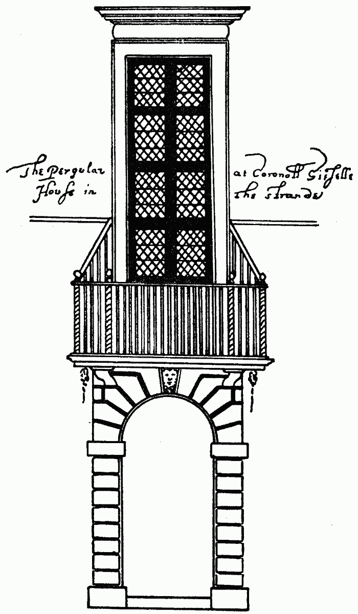
The "pergular" at Cecil House.
From a drawing in the Smithson collection
Two passages had connected the Strand with St. Martin's churchyard from mediæval times, and a lane had led from Drury Lane to the church in a line roughly parallel with the Strand. During the early part of the seventeenth century several inn yards were formed into thoroughfares, and towards the end of that century a large amount of rebuilding was carried out, and the network of small courts shown on the extract from Morden and Lea's map (p. 27) was the result. No further important alteration was carried out on the north side of the Strand until the beginning of the nineteenth century. Then Exeter Change, east of Burleigh Street, was pulled down and the street frontage westward to Southampton Street was set back. The formation of Trafalgar Square, and of Duncannon Street, Adelaide Street, King William Street and Agar Street entirely transformed the north-west corner of the Strand, and though several small courts still remain between Southampton Street and Bedford Street (formerly Half Moon Street), practically all the buildings there have been erected within recent years. A brief history of the properties on the north side of the Strand working westward from the parish boundary (the centre of Burleigh Street), to St. Martin's Lane, is given below.
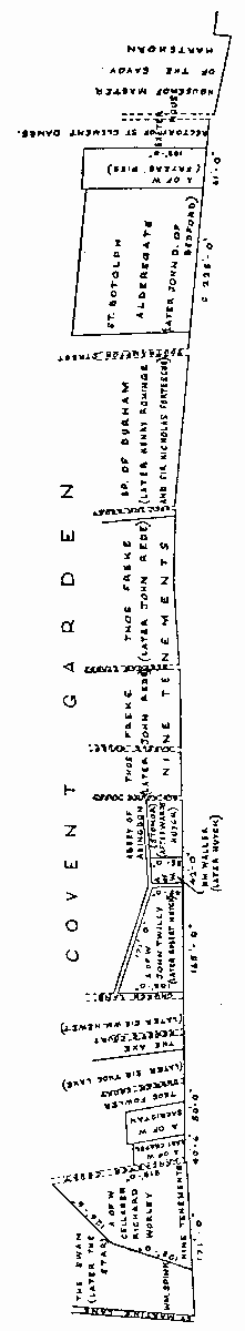
Plan of north isde of the Strand showing arrangement of properties in the reign of Henry VIII
(i) Burleigh House (afterwards Exeter House) was built on the site of the rectory of St. Clement Danes, a house of the master of the Savoy, and the Hartshorn and other tenements which had formerly been the property of Westminster Abbey. The house was begun by Sir Thomas Palmer (executed in 1553) and completed by Sir William Cecil, afterwards Lord Burghley. (fn. 336) The latter also built Cecil House adjoining it on the east which formed the residence of Sir Robert Cecil until the erection of Salisbury House on the south side of the Strand. (fn. 337) At Burghley's death his house passed to his elder son, Sir Thomas Cecil, who in 1605 was created Earl of Exeter. Cecil House was burnt down in 1627, when it was in use as the Dutch Embassy. (fn. 338) After the Restoration, Exeter House was occupied by Anthony Ashley-Cooper, Earl of Shaftesbury, who had married Frances, daughter of the 3rd Earl of Exeter. (fn. 339) Views of it are given on Norden's plan of Westminster (Plate 1b) and on the plan of the west central part of London by Hollar, which shows the corner turrets to the main building, the garden behind, and an avenue of trees with an outlet towards Drury Lane. In 1676 the house was sold for building, (fn. 93) and Burleigh Street, Exeter Street, Exeter Court, Exchange Court, etc., were erected on the site, with Exeter Change jutting out on the street frontage as Exeter House had previously. Exeter Change, famous for its menagerie, remained in existence until 1830, when it was taken down to widen the Strand. Nash originally proposed to erected a similar bazaar father back, (fn. 129) but instead the Lowther Arcade was built between Adelaide Street and the Strand through the new triangular block of buildings there where Coutts' Bank now stands.
(ii) Fryers Pies. The origin of this name is obscure. It occurs under various forms in the rolls of the Cellarer of Westminster Abbey, to whom the ground belonged. It was stated to be 58 feet wide in the earliest deed (fn. 340) to give measurements, but it may originally have been larger. (fn. n1) It was granted to John Russell, Earl of Bedford, after the Dissolution, (fn. 341) and by him leased to Arnold Oldisworth and others. (fn. 342) Part of it may have been acquired by Cecil for Burleigh House. A conduit head in or near Fryers Pies has already been mentioned (p. 120).
Marygold Alley was formed on this ground in the seventeenth century, but most of the houses there, which were small and dilapidated, were burnt down in February, 1707–8. (fn. 343) The houses were rebuilt, (fn. 99) and throughout the eighteenth century were in the occupation of small tradesmen. The Act of 7 George IV cap. 77 authorised the widening of the Strand "on the north side thereof opposite Cecil Street in an easterly direction to the east end of Exeter Change." The street frontage was taken down, and on part of the site thus cleared Exeter Hall was erected by J. T. Deering-Gandy, R.A. (fn. n2) The hall was used mainly for concerts and meetings until, in 1880, the lease was purchased for the Young Men's Christian Association. Exeter Hall, which was demolished in 1907, is shown on Plate 111b. Its massive stone entrance porch was a fine example of the Corinthian order of Grecian architecture. The capitals of the columns bore a strong resemblance to the Choragic Monument of Lysicrates at Athens (335 B.C.). One of them was obtained by the Council for the use of the students at the Brixton School of Building.
(iii) In 1403 John Bedforde and Richard Gaynesburghe presented to Richard Dereham, the parson of Saint Botolph, Aldersgate, two and a half acres of ground and two tofts in Charing Cross Street to found a yearly obit in that church for Alice Colwell. (fn. 344) After the Dissolution this property, which was then described as five tenements with gardens, was in the tenure of John Russell. (fn. 7) Part of this ground was utilised for Bedford House, the town house of the Dukes of Bedford until its demolition in 1704, when they removed to Bloomsbury. (fn. n3) During the eighteenth century there were several small courts, Coral Court, Denmark Court, etc., eastward of Southampton Street, some of which were cleared away at the time of the Strand alterations in 1830. Denmark Court was rebuilt at that time and incorporated in Exeter Street.
(iv) In addition to the ground adjoining Durham Place, the Bishop of Durham owned a garden on the north side of the road, which was sold to the King in 1536, and, like Durham Rents, came into the possession of the Fortescue family (see p. 87). (fn. 274) Henry Rominge, smith to the King, obtained a lease of a "new tenement and a cottage" (fn. 345) at the west end of this ground, the new tenement being the Black Bull Inn, (fn. 346) which remained in existence until about 1680, (fn. 347) when Bull Inn Court was formed on the site. (fn. c1) East of this were several larger houses, but these were demolished for the formation of small courts—Raindeer Court, Boyles Head Court, Lumley Court and Olivers Alley—before 1700. From the beginning of the eighteenth century onwards, the Strand frontage was entirely occupied by small traders. Bull Inn Court and Lumley Court still remain.
(v) Immediately west of the Bishop of Durham's garden was a piece of ground which at the time of the Dissolution was in private hands. At the beginning of the fifteenth century it belonged to Thomas Freke, citizen and woodmonger of London, who at his death in 1410–11 left it to his wife, Avice. (fn. 348) A century later it was in the possession of the John Rede who owned the Rounceval property (see p. 4). In 1592 there were nine tenements there which had been sold away to different owners, (fn. 349) one of them being known as the Flower de Luce (fn. c2).
Almost in the centre of the Rede property was the Half Moon Tavern, through the yard of which a thoroughfare, Half Moon Street, was made to Chandos Street. In the late eighteenth century Half Moon Street was widened to form a continuation of Bedford Street. On the east side of the Half Moon Tavern was a court taking its name from the new Exchange on the opposite side of the Strand. This court still remains between Nos. 418 and 419, Strand. East of this again were a few houses which retained their thatched roofs until the end of the seventeenth century, when they must have formed a unique feature in the Strand. (fn. n4) Thatched House Alley, shown on Rocque's map, but now swept away, was built on the site.
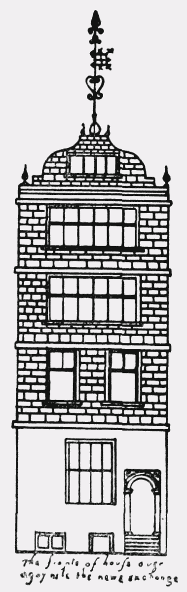
The front of a house opposite in the New Exchange.
From a drawing in the Smithson collection
Nos. 413 and 415, Strand, shown on Plate 110b, which were demolished circa 1912, are a good example of the type of houses which formerly faced the Strand. They had square projecting bays of three storeys in height over the shop premises with a wood entablature supported on panelled pilasters, and a good projecting cornice at the eaves carried on carved consoles. The shop fronts had been modernised, but Plate 15b illustrates the manner in which the shop windows were formerly divided into small squares of glass. The government office of the Dominion of New Zealand has been built on the site of Nos. 413 and 415, Strand, but Heathcock Court which ran between them still remains. (fn. n5)
The original Adelphi Theatre (the Sans Pareil), east of Heathcock Court, was first opened in 1806. Pierce Egan's Tom and Jerry was produced there in 1821, and the theatre at once became popular. It was rebuilt in 1858, and the Strand front was widened and entirely altered in 1887–8.
(vi) West of Rede's property was a garden which in the fifteenth century was held by the Abbot of Abingdon and his tenants, the Stonor family, who also held a considerable amount of land in other parts of Westminster. This garden, after the Dissolution, was granted to Robert Huyck, "Phisitian to the Quenes grace," who also obtained a long lease of the Westminster Abbey property adjoining which had previously been leased to John Twilly and William Waller. (fn. 352) Huyck pulled down "the olde Ruynose Cotages and deforme dennes and buylded new hansome and comly tenements" there "to the extirpacion of beggerye and other annoyaunces," (fn. 353) and in consideration thereof was allowed to move the public way to St. Martin's Church (shown on the plan) farther west, i.e. to Church Lane. (fn. 354)
Extensive alterations were carried out to this property circa 1700 when New Round Court, Southouse Court, etc., were formed. (fn. 99) The lay-out of the ground had been so much altered during the period of Huyck's lease that the boundaries became a subject of dispute, and several plans, now among the Abbey muniments, were drawn to clear up the matter. Part of the street frontage of this property (then numbered 442–53, Strand) in 1824 is shown on Plate 15b. Six years later, the whole of this area was cleared for the formation of Trafalgar Square and of the triangular blocks of buildings which now lie between St. Martin's Church and the Strand.
The building illustrated on Plate 111a, stood, until 1908, at the corner of Agar Street on the site of Rhodesia House. It was originally designed by Professor Cockerell, R.A., (fn. n6) as the Westminster Insurance Offices. It exhibited the refinement of classic detail that is always found in this great artist's work, while the treatment of the pediment was a foretaste of a feature which was developed in many of his later buildings. The elegant figures to the arched heads of the first-floor windows to the street front and the tasteful ironwork to the balconies are worthy of note. Prior to their demolition these premises were used by the British Medical Association.
(vii) West of Church Lane were two pieces of property in private hands, the Axe, which afterwards came into the possession of the Hewet family from whom Hewet's Court later took its name, and the ground granted by Henry VIII (fn. 4) to Thomas Fowler, later Controller of the Queen's Works, who is sometimes stated to have been the stepfather of Ben Jonson (see footnote to p. 22). Fowler's house was afterwards occupied by Sir Thomas Lake, Secretary of State to James I. (fn. n7) Church Court was formed on this property at the end of the seventeenth century. The west end of the block of buildings between Adelaide Street, King William Street and the Strand now covers the site.
(viii) At the west end of the Strand lay three gardens belonging to officials of Westminster Abbey, the sacristan, the keeper of the Lady Chapel, and the cellarer. These remained in the possession of the abbey after the Dissolution, and were leased to various tenants. (fn. 152) Several inns were erected there—the King's Head (site of Lancaster Court), the Three Tobacco Pipes, and the Bear and Ragged Staff. By the end of the eighteenth century the area in the immediate neighbourhood of St. Martin's Church had become very squalid, and the clearance made in 1830 was as welcome as it was overdue. The site of the Swan Inn, later the Star, at the south-east end of St. Martin's Lane, became part of Trafalgar Square.