Survey of London: Volume 22, Bankside (The Parishes of St. Saviour and Christchurch Southwark). Originally published by London County Council, London, 1950.
This free content was digitised by double rekeying. All rights reserved.
'Upper Ground and Boddy's Bridge', in Survey of London: Volume 22, Bankside (The Parishes of St. Saviour and Christchurch Southwark), ed. Howard Roberts, Walter H Godfrey (London, 1950), British History Online https://www.british-history.ac.uk/survey-london/vol22/pp108-110 [accessed 30 April 2025].
'Upper Ground and Boddy's Bridge', in Survey of London: Volume 22, Bankside (The Parishes of St. Saviour and Christchurch Southwark). Edited by Howard Roberts, Walter H Godfrey (London, 1950), British History Online, accessed April 30, 2025, https://www.british-history.ac.uk/survey-london/vol22/pp108-110.
"Upper Ground and Boddy's Bridge". Survey of London: Volume 22, Bankside (The Parishes of St. Saviour and Christchurch Southwark). Ed. Howard Roberts, Walter H Godfrey (London, 1950), British History Online. Web. 30 April 2025. https://www.british-history.ac.uk/survey-london/vol22/pp108-110.
In this section
CHAPTER 20: UPPER GROUND AND BODDY'S BRIDGE
Upper Ground is the oldest thoroughfare in Christ Church parish. It is the descendant of the path which from the Norman period, and perhaps earlier, ran along the inside of the embanking river wall; and it still retains the narrowness and the twists and turns characteristic of a country lane. Before the formation of the railway it extended eastward across Blackfriars Road as far as Bankside. (fn. n1) At the eastern end it bridged the mill stream which flowed from the mill pond (on the site of the junction of Hopton Street with Gravel Lane) to the Thames. The sewer or stream feeding the mill pond ran along the south side of Upper Ground and thence in a circular course round the manor.
At the west end Upper Ground extended, as it still does, to Broadwall. During the Tudor and early Stuart periods, and perhaps earlier, the King's Barge House occupied the piece of land to the north-west of Upper Ground. This, however, appears to have been a part of Prince's Meadow and not to have been included in the manor of Paris Garden though it is now in Christ Church parish. Both the Barge Houses and Pudding Mill are clearly shown in the map of the northern part of Paris Garden, referred to in Manning and Bray's History of Surrey, and now in the possession of Mr. R. A. Bell. The Barge House is now only commemorated in the narrow alley leading out of Upper Ground and over steps to a landing stage on the river strand—the successor of the "stairs near the Barge House" shown on the 1627 map (Plate 65).
Most of the land on the north side of Upper Ground was copyhold and was built on from a very early date. The making of Blackfriars Road and the opening up of the neighbourhood drew attention to the dirty and almost impassable state of Upper Ground. In 1791 an Act (fn. 234) was passed "for paving, cleansing, lighting, watching, widening, regulating and improving" it, and Commissioners were appointed with power to widen the street at either end, to number the houses, provide beadles and a watch house, and to clean and water the roadway.
No. 26 Upper Ground
No. 26 Upper Ground is a three-storey house of simple design in brick, with a plain stone band at first floor sill level. The windows to the first and second floors have flat gauged arches, while those on the ground floor have round heads set in semicircular arched recesses. All the window frames on the front retain their small panes and glazing bars. The entrance is deeply recessed with a semicircular arched head in brick and the sides and soffit are panelled in wood.
This house was built (probably just after the improvement to the street made under the Act of 1791) by Edward Lefort and his sons, who established a barge and boatbuilding business on the north side of Upper Ground near Bull Alley. Edward Lefort was admitted to the copyhold of a wharf and ground there in 1803. (fn. 203) His son William Lefort died in 1821 and in his will mention is made of extensive rebuilding carried out at the premises in Upper Ground Street. Subsequent owners of the property were John Barnard, timber merchant (1826), Wm. Lee & Sons, lime-burners (1849), and Thomas Reeve Denny & Sons, corn merchants and rice millers (1887 to date). The property was enfranchised in 1889. (fn. 203)
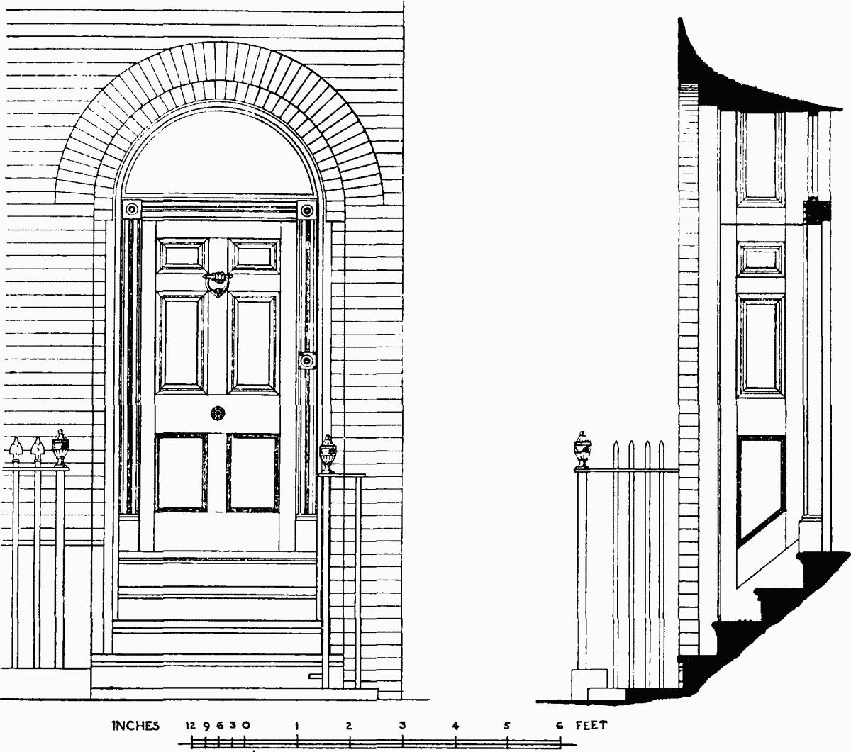
Doorway to No. 26 Upper Ground
The Angel Public House
No. 41 on the south side of Upper Ground stands on the site of a much older building. William Warner of the Angel in Upper Ground issued a trade token in 1669, (fn. 235) and it seems probable that the house had then been recently named in compliment to William Angell, lord of the manor. The present building dates from the middle of the 19th century.
Boddy's Bridge
Boddy's Bridge, a small turning on the south side of Upper Ground, is now closely hemmed in by high buildings. To the east of it is an oblong paved court approached only by steps from Boddy's Bridge. The houses round the court are now derelict. The court must originally have been similar in appearance to Queen's Arms Court, which formerly opened out of Upper Ground to the west of Boddy's Bridge and of which an early 19th-century view is reproduced on Plate 80b.
Nos. 10, 12 and 14 Boddy's Bridge are two-storey houses with dormers. Nos. 12 and 14 are of red brick with a plain brick string course below the first floor windows. No. 10 has been refaced. The tiled roofs are of the mansard type, the upper slope being of pantiles. The two first floor windows to No. 14 retain their original sashes and glazing bars in flush frames; others are recessed and that on the first floor of No. 10 is a modern casement (Plate 79a).
In a list of newly built tenements circa 1634 (fn. 80) mention is made of a brick and timber tenement "builded by Richard Boddy" in 1631 on a new foundation on the land of Thomas Browker, i.e., on part of the demesne land of the manor of Paris Garden. Presumably Richard Boddy bridged over the sewer in front of the house for in the Token Books from 1630 to 1642 there are entries referring to him as living by "Bodyes Bridg" in Upper Ground.
Richard Boddy's grandson, John Boddy, "waterman," died in 1703/4 leaving his freehold property by Boddy's Bridge and his copyhold tenements on the north side of Upper Ground to his sister Rachel Graves and her son John as residuary legatees. (fn. 236)
A court with houses on either side and a bridge over the sewer to Upper Ground is marked on Morden and Lea's map of 1682 on the site of Boddy's Bridge, but is not named. It is shown and named on Rocque's map (Plate 2). Several of the existing houses in Boddy's Bridge appear to date from the early years of the 18th century. They were probably built either by John Graves or by George Sterry his nephew, who inherited the property in 1722. (fn. 203)