Survey of London: Volume 27, Spitalfields and Mile End New Town. Originally published by London County Council, London, 1957.
This free content was digitised by double rekeying. All rights reserved.
'The estate of Sir Charles Wheler and the Wilkes family', in Survey of London: Volume 27, Spitalfields and Mile End New Town, ed. F H W Sheppard (London, 1957), British History Online https://www.british-history.ac.uk/survey-london/vol27/pp108-115 [accessed 30 April 2025].
'The estate of Sir Charles Wheler and the Wilkes family', in Survey of London: Volume 27, Spitalfields and Mile End New Town. Edited by F H W Sheppard (London, 1957), British History Online, accessed April 30, 2025, https://www.british-history.ac.uk/survey-london/vol27/pp108-115.
"The estate of Sir Charles Wheler and the Wilkes family". Survey of London: Volume 27, Spitalfields and Mile End New Town. Ed. F H W Sheppard (London, 1957), British History Online. Web. 30 April 2025. https://www.british-history.ac.uk/survey-london/vol27/pp108-115.
In this section
CHAPTER VIII - The Estate of Sir Charles Wheler and the Wilkes Family
This estate had formed that part of the Spitalfields property of Sir William Wheler, which in 1674 came into the possession of Sir Charles Wheler of Birdingbury, Warwickshire, a kinsman of Sir William's, and heir, by special remainder, to his baronetcy. (fn. 1) By his will, made in 1665 and proved in July 1667, (fn. 2) Sir William had left all his Spitalfields property, together with other property, to Charles Wheler of Charing, Kent, and his son George (later the Rev. Sir George Wheler, knight), subject to his widow's life interest. But although it does not appear in his will, Sir William had evidently made provision, as Sir George Wheler later conceded, for ’the Devision of Spittlefields, out of which Sir Will, had left six score pounds a year to go along with ye Barronett for ever, and to be Divided by the Chanceller’. (fn. 3) To obtain this, Sir Charles chal lenged Charles and (Sir) George Wheler's rights under Sir William's will in a Chancery suit. Sir George recorded his opinion of the judgment. ’The Lord Shaftesbury Decreed on our side, but Did not stay in [the office of Lord Chancellor] Long enough to finish the Devision of Spittle fields. … But when Lord chancellor Finch was made so,… having bene Sir Charles his Counsel in ye cause, [he] Declared that if Sir Charles could have no more than six score pounds per An., he wd make it the best six score he could’, and therefore made such a division ’that ye Ground rents for six score contained a far greater Quantity of ground then the Remainds, whose then rents was about four Hundred pounds per An’. Sir George and his father accepted the judgment, ’ye Lord Chancellor being Sir Charles his Friend’. (fn. 3) The Chancery order was made on 31 March 1674. (fn. 4) The part of Spitalfields to be divided lay north of the line of Brown's Lane and Lamb Street, being bounded on the east by Brick Lane and on the north and west by the hamlet boundary. Sir Charles's portion (fig. 27) comprised, in the main, the south-eastern part of this ground. Its western boundary north of the ditch dividing Quaker Street from Great Pearl Street (now Calvin Street) was approximately Grey Eagle Street and Farthing Street: south of the ditch it was Wheler Street. In its extreme south-east corner it excluded a plot of ground on the northern corner of Brown's Lane (Hanbury Street) and Brick Lane (see pages 192–3). It included perhaps more than half of Sir William Wheler's estate, but not so clearly the greater part as Sir George Wheler's words suggest.
This part of Sir William Wheler's property had, like the rest, been first built up by Sir William and his lessees in the 1650's and 1660's. In 1675 Sir Charles asked for licence to build on a few undeveloped sites. Sir Christopher Wren reported favourably and in August licence was granted. (fn. 5) Comparison of Wren's plan appended to the patent with Ogilby and Morgan's map of 1681–2 suggests that by the latter date some of the sites had been filled.
In June 1680 Sir Charles mortgaged his property for a thousand years to Elizabeth Browne of St. Paul's, Covent Garden, to secure £1,060. This mortgage appears subsequently to have become an absolute lease. Elizabeth Browne assigned it to Daniel Hough in trust for Ralph Hardwick of London, merchant, and in January 1681–2 Hough assigned the mortgage in consideration of £1,600 to John, first Baron Ossulston. (fn. 6) Hardwick and Hough borrowed a further £200 from Lord Ossulston. In 1696 the first Lord Ossulston's heir, Charles, brought a complaint in Chancery: the rents of the property were said to be insufficient to pay the interest on the £1,800 and to be expensive to collect ’being small and in many particulars’. Hardwick and Hough were also said to have let the property ’goe to ruine’. In 1702 the defendants were ordered to pay the outstanding debt, then amounting to £2,254 16s. 6d., or lose possession. The money was not paid and Lord Ossulston obtained possession. (fn. 7) There was, however, further borrowing between the parties on security of the property. In March 1714/15 Lord Ossulston, who had become first Earl of Tankervile of the second creation, assigned the property to Thomas Umfrevile, citizen and tin plate-worker, (fn. n1) for £1,570, Umfrevile having previously also paid £1,183 1s. 8d. to Hardwick, whose heir conveyed his interest to trustees for Umfrevile. (fn. 8) Umfrevile and his trustees promptly assigned the property to Richard Brodrepp of South Mapperton, Dorset, esquire, and his trustees. (fn. 9) In December 1718 a trustee for Brodrepp conveyed the property to Edward Umfrevile of Fetter Lane, gentleman, and Israel Wilkes, citizen and distiller of London. (fn. 10) Wilkes, whose distillery was in Clcrken well, was the father of the celebrated John Wilkes.
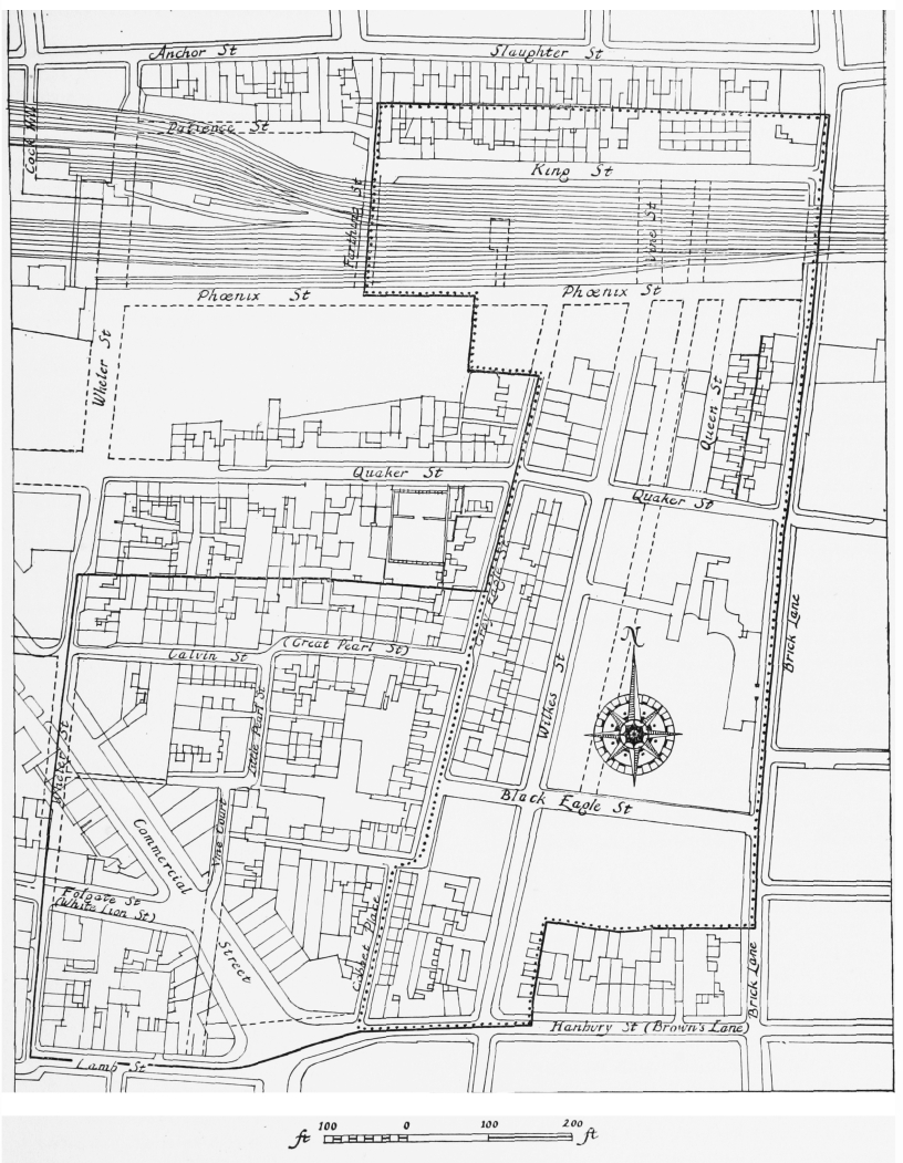
The estate of Sir Charles Wheler and the Wilkes family, lay-out plan. Based on Horwood's map and on the
Ordnance Survey 1873–5
––––– Part of Sir William Wheler's estate inherited by Sir Charles Wheler
. . . . Part of Sir Charles. Wheler's inheritance owned by Israel Wilkes in late seventeenth century
------- Streets shown on Horwood's map
In the course of the next quarter of a century or so Israel Wilkes and Umfrevile, or Wilkes alone after Umfrevile's death, sold various parts of the property, some to other members of the Umfrevile family. These parts are not easily identifiable but probably constituted all the property lying west of Grey Eagle Street. (fn. 11)
French Church, Pearl Street
Pearl Street is now Calvin Street
Demolished
By 1697 Jacques Laborie, whose congregation at l'Eglise de l'Artillerie had seceded in 1694, had founded anew church in Pearl Street (now Calvin Street). In 1699 some new scandal drove Laborie to emigrate to America. The Pearl Street Church continued until early in 1 701, when it united with Crispin Street Church (fn. 12) (see page 138). It has been suggested that the church occupied a site on (he north side of Pearl Street, near Grey Eagle Street, (fn. 13) perhaps identifiable with the commercial premises shown on Horwood's map of 1799.
No. 27 Jerome Street and Nos. 10 and 11 Calvin Street
Formerly No. 9 Little Pearl Street and Nos. 10 and 11 Great Pearl Street
Rate books suggest that these houses (Plate 73b) may have been built between 1793 and 1803, when they were held on lease by Charles Beek, esquire, (fn. 14) of Mile End New Town, probably from Ann Williams of Lambeth, daughter of Edward Williams of Bishopsgate Street, gentleman. In 1792 and 1793 Ann Williams had granted building leases to other lessees of sites on the west side of Jerome Street. (fn. 15)
Nos. 10 and 1 1 Calvin Street are paired houses with mirrored plans, three storeys high, and the fenestration in the plain stock brick front clearly shows that they were built for weavers’ occupation. The cement-faced ground storey contains the doorway and a sashed window of normal proportions, above which is a wide sashed window of three lights. In the top storey is a four-light casement extending the full width of the frontage. All the window openings have segmental-arched heads.
Nos. 15 and 16 Calvin Street
Formerly No. 15 Great Pearl Street
This building (fig. 28) was probably erected between 1809 and 18l2. Between at least 1773 and 1803 a building on this site was occupied by James Lewis Desormeaux, a black-silk dyer, (fn. 16) who succeeded Abraham Desormeaux, also a dyer. In 1786 he acquired the freehold of the house and dyehouse on the site from the widow of Edward Williams of Bishopsgate Street. (fn. 17) In May 1809 Desormeaux conveyed the house and dyehouse to Isabella and Francis (later Sir Francis) Des Anges, dyer. (fn. 18)
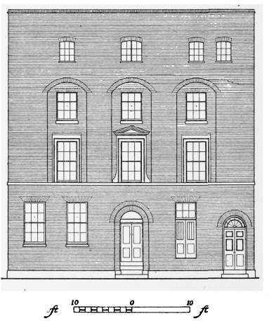
Nos. 15 and 16 Calvin Street, ? 1809–12, front elevation
The present building apparently existed by 1812. (fn. 19) It was in dual occupation from the beginning, one of the first occupants being the firm of Hague and Topham, millwrights, who had an iron-foundry in Grey Eagle Street with which the back of Nos. 15–16 probably communicated. (fn. 20)
The elegance and generous scale of the early nineteenth-century front are in striking contrast with its humble setting. It is well built of yellow and pink stock bricks, with a cement plinth and a narrow bandcourse at first-floor level. Centred in the lofty ground storey is a round-arched doorway set in a marginal recess. On the left are two sash windows with flat arches of gauged brick, and on the right is another window, now altered, and a smaller doorway which is furnished with a cobweb fanlight. There are three equally spaced windows in the first storey and three in the second, both tiers being set in three shallow recesses with segmental heads of gauged brickwork. The first-storey windows are dressed with wooden architraves, the middle one being accented with ramped jambs and a triangular pediment. Each side window was doubtless finished with a cornice, now missing. The top storey has been refronted with, presumably, different fenestration.
The Wilkes Estate
The part of Sir Charles Wheler's inheritance east and north of Grey Eagle Street was owned in the mid-eighteenth century by the Wilkes family. In 1743 the greater part, if not all, was owned by Nathaniel Wilkes, nephew of Israel Wilkes, but it is not known by what means the property passed from Israel to his nephew rather than to his sons.
The section of the estate lying between Mon mouth Street, Brick Lane, Black Eagle Street and Quaker Street was partly occupied by the owners of Truman's Brewery, to whom in 1743 Nathaniel Wilkes granted a renewal of their lease, and who by the end of the eighteenth century occupied the whole of this section (see Chapter IX).
The main development on the Wilkes estate was in the third quarter of the century, with the piecemeal construction of a line of street as a continuation of Wood Street, on the Wood-Michell estate, northward from Brown's Lane to King Street. The four parts of the continuation, marked by the crossing of Black Eagle Street, Quaker Street and Phoenix Street, were named in succession northward John Street, Wilkes Street, Hope Street, and Vine Street. Part of Hope Street and all of Vine Street have been obliterated by the railway, and the others, together with Wood Street, have been renamed Wilkes Street.
In November 1752, when the Spitalfields Vestry had considered acquiring the Black Eagle Street chapel for use as a workhouse, ’Mr. Wilks’ declined to grant a lease as 'he intended to make an Open Street from Wood Street through the back part of the premises'.21 In March of the following year Nathaniel Wilkes, then of Wendon Lofts, Essex, esquire, granted a ninety-nine-year lease to John Lorrington of St. Mary Magdalen Bermondsey, bricklayer, of the piece of ground bounded by Grey Eagle Street, Monmouth Street, Black Eagle Street and Quaker Street. The witnesses included Samuel Worrall of Spitalfields, gentleman. (fn. 22) It was not a building lease but by December 1757 Wilkes Street had been built through the centre of this plot, approximately on the line of Hockenhull Court, and Lorrington granted a lease of a house newly built by him at the south-east corner of the street. (fn. 23)
The construction of Wilkes Street so close to Monmouth Street necessitated the demolition of the houses on the west side of that street, which was henceforward occupied by the back gardens of the houses on the east side of Wilkes Street.
John Street had been in contemplation in 1752 and would seem naturally to be the first part of the continuation of Wood Street to be built, but was not in fact constructed until the period between 1766 and 1773. It was perhaps built by John Wilkes, a son of Nathaniel Wilkes who had died between May 1758 and October 1759.
In his will Nathaniel left his Spitalfields estate to trustees for his married daughter. (fn. 24) This bequest appears, however, not to have taken effect, and building leases were granted in the 1760's successively by his sons John and Hope Wilkes. Some of these were not on the Wood Street line. In 1761 John Wilkes, of Wendon Lofts, granted leases of sites in Grey Eagle Street and Phoenix Street to Thomas Holloway of Shoreditch, builder, who had built new houses on them. (fn. 25) Two years later he granted a lease of ground on the south side of King Street and bounded by Brick Lane and Monmouth Street to James Laverduer (or Laverdure) ’otherwise Green’, of Spitalfields, carpenter, who was to build on the Brick Lane frontage. (fn. 26)
The northern continuation of the Wood-John-Wilkes Streets line was probably laid out in the late 1760's or early 1770's. In 1765 Hope Wilkes, of Wendon Lofts, granted a building lease for eighty-seven and three-quarter years to Thomas Vine of Spitalfields, carpenter. The site lay west of Monmouth Street, and was bounded north and south by King Street and Phoenix Street. On this site Vine was to build within two years sixteen or more houses, at a cost of at least £1,500, and form a new street to be called Vine Street. The lease laid down details for the scant lings and specified that there should be two courses of bond timber in each storey. A wooden bar was to be placed at each end of the street to prevent the passage of carts and carriages, and only one 'public alehouse or victualling house' was to be built on the site. Five feet on each side of the new street were to be paved with Purbeck stone within two months of the erection of the houses. (fn. 27)
Vine had recently built houses and gardens adjoining the site to the west, under lease from Hope's brother John, forming the small square called by Horwood Elizabeth's Court.
Vine Street was constructed at the northern extremity of the line of street before ’Hope Street’ to its south was built. The latter appears to have been built-up in the 1770's. Two houses were built on the west side by Francis Garland in March 1772. (fn. 28) Four more new houses were built by ’Mr. Mooring’ in May 1777 and four more in ’Sauers Buildings’ on the west side by Jacob Sauer in November 1781. (fn. 29)
In March 1782 Hope Wilkes granted a seventy-year lease to Richard Wooding of Spital-fields, surveyor, (fn. n2) and John May Evans of the same, bricklayer, whereby they were to complete sixteen new houses forming King Square, north of Phoenix Street and west of Brick Lane. (fn. 30) Evans was also responsible for building in the new Union Street at about this time.
The date of the construction of Queen Street, part of which survives as the cul-de-sac Sheba Street, is not known. It is shown by Horwood in 1799 but not by Rocque in 1746.
In the nineteenth and early twentieth centuries the character of the estate was altered by the growth of Truman's Brewery, the construction of the Eastern Counties Railway line, and the ex pansion of this line by the Great Eastern Railway Company.
In 1831 and 1842 leases to the brewery partners resulted in the absorption of most of the estate east of Wilkes Street and south of Black Eagle Street into the brewery by the late 1850's. This leasehold estate was sold to the brewery in 1904 (see page 119). Between 1839 and 1847 John Wilkes conveyed to the Eastern Counties Railway Company that part of the estate which lay north of Phoenix Street for the construction of the line to the Shoreditch terminus. (fn. 31) In 1871, on the expansion of the line, further property on the south of Phoenix Street was sold to the Great Eastern Railway Company. (fn. 32) In 1876 ground south of this, abutting south on Quaker Street, was sold to the Company for the site of the Great Eastern Buildings (see below), and in 1880 a piece of ground at the northern extremity of the estate was sold for a further expansion of the line. (fn. 33)
Black Eagle Street Chapel and French Almshouses
Formerly l'Eglise de l'Hôpital
Demolished
In 1687 James II issued letters patent to the French Church of Threadneedle Street, permitting the foundation of a chapel of ease in Spitalfields. (fn. 34) The site of the new building was to be a piece of ground on the corner of Black Eagle Street and Grey Eagle Street, of which the Threadneedle Street Church already held a lease. It was then occupied by 'certain old Almeshouses' belonging to the church, which the recipients of the patent intended to ’pull downe to rebuild anew upon some part of the said ground’. (fn. 35) These almshouses, which are shown by Ogilby and Morgan in their map of 1677 on the south-east corner of the two streets, had been given by Paul Docminicq and his wife Marie Tordreau. (fn. 36) The new church was to be built on the northern part of the site, fronting on Black Eagle Street, and was to measure about eighty feet by fifty-four feet. A plan of the church and of four of the rebuilt aims-houses is preserved in a deed of 1831. (fn. 37) The church was known as l'Eglise de PHopital, probably because of the almshouses, which Maitland described in 1739 as providing ’convenient Apartments for Forty-five poor Men and Women, who are allow'd Two Shillings and Three-pence, and a Bushel of Coals each Weekly, and Apparel every other Year'. (fn. 38) This implies that there were originally more almshouses than are shown on the plan of 1831. Those which disappeared may have stood on the ’back part of the premises adjoining to the … Church’, which was taken in the middle of the eighteenth century for the northward extension of Wood Street. (fn. 21)
In 1718 a charity school was established in connexion with the church, (fn. 39) and in 1739 it contained one hundred boys and one hundred girls. (fn. 40) The children were taught and clothed free of charge. (fn. 39)
In 1742 the church building was described as ’now decaying’, and the lease of the property as ’near expiring’. Instead of renewing it, the Threadneedle Street Church obtained a licence to build a new church and schools at the corner of Church (now Fournier) Street and Brick Lane. (fn. 41) When these buildings were completed in 1743, the French congregation left Black Eagle Street (see page 221).
On Rocque's map of 1746 the Black Eagle Street building is shown as a Methodist chapel. John Wesley preached there on a number of occasions between 1750 and 1763. In 1755 he spoke to a congregation ’to the number of about eighteen hundred persons’. (fn. 42) In 1763 he recorded the following experience: ’Preaching in the evening at Spitalfields, on ’"Prepare to meet thy God”, I largely showed the utter absurdity of the supposition, that the world was to end that night. But notwithstanding all I could say, many were afraid to go to bed, and some wandered about in the fields, being persuaded, that, if the world did not end, at least London would be swallowed up by an earthquake.’ (fn. 43) The Methodists apparently did not hold the property on a long lease, for in November 1752 it was offered to Christ Church parish as a workhouse. (fn. 44) While this proposal was under consideration, Nathaniel Wilkes, the owner, changed his mind, and decided to retain the property in order to extend Wood Street northward through part of it. (fn. 21)
The Methodists remained in Black Eagle Street Chapel until 1819, when they moved to the former French church in Church (Fournier) Street (see page 223). The Black Eagle Street property was leased by John Wilkes to Truman's brewery in 1831, by which time the chapel had become a warehouse. (fn. 37) It probably survived until 1895. (fn. 45)
French House of Charity and Corbet's Court French School
Demolished
In 1739 William Maitland described the work of a ’French-House of Charity’ in Spitalfields, ’commonly call'd the Soup’. It had been ’erected about Forty-five Years ago, for the Relief of necessitous Families, whose Number, in the Year 1733 amounted to Two hundred and Ninety-six’. At first the charity made gifts of money, but these were soon replaced by portions of food, each consisting of broth, bread and meat. (fn. 38) The charity was mentioned again in 1746 (fn. 46) and in 1754. (fn. 47) On Rocque's map of 1746 it is located in Corbet's Court, where Maitland mentions the existence of a French charity school for fifty boys and fifty girls, (fn. 40) run under the same management as ’the Soup’. (fn. 38)
Hope Street Chapel
Hope Street now part of Wilkes Street
At some time between 1769 and 1786 a Baptist congregation met for a short period in Hope Street, Spitalfields. (fn. 48) In 1787 an Independent chapel was opened in Hope Street, which continued until September 1836. (fn. 49) In 1811 the chapel is called ’Calvinist’ (fn. 50) and in 1813 'Methodist'. (fn. 37) In 1836 the chapel was apparently closed, but it must have been re-opened almost at once by the Rev. William Tyler. In 1844 Tyler moved to Church Street chapel in Mile End New Town, taking his congregation with him. (fn. 51) The chapel is shown on a lease of 1853, but at this time it does not appear to have been occupied by a congregation. By 1903 it had become a synagogue. (fn. 52)
The chapel was built on the land at the rear of Nos. 93 and 95 Wilkes Street, and entrance lobbies and a stair to the gallery were formed in the existing houses. The chapel is a plain square room of late eighteenth- or early nineteenth-century character, lit by two round-headed windows and with a flat ceiling in place of the former dome. (fn. 52) The gallery, which has a panelled front, runs round three sides, supported on cast iron columns. The building is now used as a bakery.
Nos. 20–26 (even) Wilkes Street
Formerly Nos. 12–9 (consec.) John Street
Rate books suggest that these houses (Plate 71d) were perhaps built about 1818. It is not known whether they were then already leased to Truman's Brewery, by which they were held before 1842. In the mid-nineteenth century they were Occupied by employees of the company.
Nos. 20–26 are terrace-houses containing a cellar-basement and three storeys. The plain fronts are built of yellow and pink bricks, except that of No. 26 which is of plum-coloured bricks. Each house has one window placed more or less centrally in the ground storey and two in each upper storey, all having segmental arches of brick, stone sills, and plastered reveals. The sashes retain all their glazing bars, the ground-floor windows are furnished with external shutters, and the eight-panelled front doors are set in round-arched openings, with plastered reveals and lunettes.
These houses are well maintained and their neat fronts, with the woodwork painted in gay colours, are in striking contrast with the squalid decay that has overtaken so many of the houses nearby.
Nos. 47–85 (odd) Wilkes Street
Formerly Nos. 1–20 (consec.) Wilkes Street
Nos. 47–51 demolished
The original ground- and first-floor storeys of these houses (Plate 71c) were built between 1753 and 1757 by John Lorrington of Bermondsey, bricklayer (see page III). The date of the addition of the top two storeys, of which the upper consisted in 1897 of workshops (fn. 53) is not known, but may have been in 1873 when twenty-one-year repairing leases of Nos. 63–85 were granted to R. C. Cook of Norton Folgate, builder. (fn. 54) In 1894. the whole range, being ’in a very ruinous and dilapidated state’, was leased to Harry Richardson of Finsbury Square, surveyor, who undertook to spend £300 on the repair of each house. (fn. 55) In 1897 the houses were said to be ’too old to stand any longer’. (fn. 53)
Nos. 53–85 (odd) form the large surviving part of the uniformly designed terrace of houses, built in pairs with mirrored plans (fig. 29). Each house originally consisted of a cellar-basement,two storesy, and, presumbly, a weavers’ garret in the roof, the last being replaced by two more storeys when the houses were reconstructed to torm tenements. The original fronts are built of plum-coloured bncks with red brick segments] arches to the first-floor windows, of which each house has two centred over the ground-floor win- dows with a blank space above the doorway. The segmental arches of the ground-floor windows have been concealed by cement lintels with keyblocks, and the doorways have crudely designed surrounds of cement. Some of the original front doors survive, with raised-and-fielded panels in moulded framing. These doors, together with the flush frames and heavy glazing bars in some of the windows, suggest that the houses are older than documentary evidence proves them to be. There are three segmental-arched windows, with recessed sashes, in each of the added storeys.
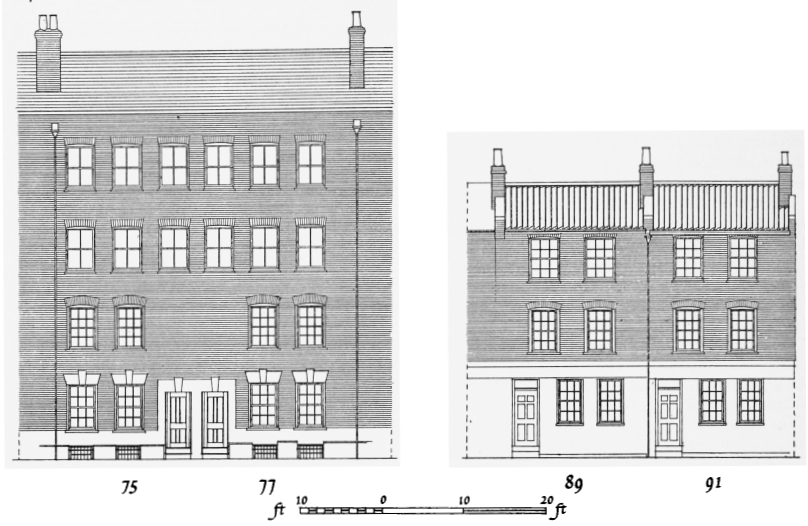
Nos. 75–77 (1753–7) and 89–91 (? c. 1770) Wilkes Street, front elevation
Nos. 87–91 (odd) Wilkes Street
Formerly Nos. 12–10 (consec.) Hope Street
The lower storeys of these houses (fig. 29) are similar to those built by John Lorrington in ’Wilkes Street’ in the 1750's and may conceivably have been built at the same period, as a court or cul-de-sac north of Quaker Street. (fn. n3) The northern part of the street was probably first cut through in the 1770's and 1780's. In 1897 Nos. 87–91 were said to be ’very old and worn’ and it was anticipated that ’the state of repair will have to be very carefully watched to enable the houses to stand' until the expiry of a lease in 1951. (fn. 56)
Nos. 87–91 (odd), although not built in pairs, were probably similar in their original form to Nos. 53–85, and have one added storey replacing the original garret.
Great Eastern Buildings, Quaker Street
When the Great Eastern Railway Company began an enlargement of Liverpool Street Station in 1887, the number of persons displaced by the demolition of ninety-three houses in St. Botolph's Bishopsgate was estimated at 600 (fn. 57) for whom the Company was required to provide alternative accommodation by the General Powers Act of the same year. One of the three blocks of buildings built for this purpose was begun early in 1890 (fn. 58) at the north-east corner of Quaker Street and Wilkes Street. It was to contain twenty-four one-room and sixty-eight two-room tenements, giving accommodation for 320 persons. The building was completed by October 1890, (fn. 57) in compliance with the agreement made with the builder, Mark Gentry, whose tender was for £13,776. The architect was John Wilson, engineer to the Great Eastern Railway Company. (fn. 58)
Great Eastern Buildings consist of two long blocks, two rooms deep and four storeys high, placed at a right angle to Quaker Street with the fronts facing each other across an open-ended court. Each block is divided into three sections, with four tenements on each floor, and all the storeys were originally similar in arrangement. Every group of four tenements was allotted two water-closets and one scullery, leading off the staircase landing.
The elevations are of yellow stocks with bands of red brick just above the sills of the windows, which have segmental arches of red brick. Giant pilasters, also of red brick, are placed at each end of the front and flank the tall openings that light and ventilate the three staircases.