Survey of London: Volumes 43 and 44, Poplar, Blackwall and Isle of Dogs. Originally published by London County Council, London, 1994.
This free content was digitised by double rekeying. All rights reserved.
'Pennyfields', in Survey of London: Volumes 43 and 44, Poplar, Blackwall and Isle of Dogs, ed. Hermione Hobhouse( London, 1994), British History Online https://www.british-history.ac.uk/survey-london/vols43-4/pp111-113 [accessed 27 July 2024].
'Pennyfields', in Survey of London: Volumes 43 and 44, Poplar, Blackwall and Isle of Dogs. Edited by Hermione Hobhouse( London, 1994), British History Online, accessed July 27, 2024, https://www.british-history.ac.uk/survey-london/vols43-4/pp111-113.
"Pennyfields". Survey of London: Volumes 43 and 44, Poplar, Blackwall and Isle of Dogs. Ed. Hermione Hobhouse(London, 1994), , British History Online. Web. 27 July 2024. https://www.british-history.ac.uk/survey-london/vols43-4/pp111-113.
In this section
CHAPTER V - Pennyfields, Ming Street and West India Dock Road
Until the setting out of the Commercial Road in 1802, access to Poplar and Blackwall from Limehouse and Whitechapel was through the narrow streets of Limehouse itself, and from there along Limehouse Causeway and Pennyfields into the High Street. Following the completion of the Commercial Road, which abutted the western ends of Pennyfields and the byway which became King Street, the approach to Poplar High Street from the west was much improved (fig. 30). That section of the Commercial Road from its junction with the East India Dock Road to the West India Docks was not referred to as the West India Dock Road until 1828, and the name was not widely used until the later 1830s. (fn. 1)
Pennyfields
It is perhaps more for its social than its architectural history that Pennyfields merits recording. Sited at the western end of Poplar High Street, Pennyfields, with its low-class housing and shops, formed a 'buffer' between the shabby respectability of the High Street and the exotic Oriental underworld of Limehouse Causeway to the west. During the closing decades of the nineteenth century and the early years of the twentieth, Pennyfields was a strange mixture of both societies. By the inter-war years the street had become the centre of the Chinese East End. All the buildings associated with the street's colourful past have been demolished, however, replaced by public housing during the 1960s (see page 92). (fn. 2)
The origins of Pennyfields are obscure, hidden in the landholding complexities of the manor of Stepney. Some properties were held by manorial tenure well into the twentieth century. (fn. 3) A little development appears to have taken place prior to 1650, but a map of c1573 seems to suggest that Pennyfields was an undeveloped way joining the two built-up streets of Limehouse Causeway and Poplar High Street (Plate 145a). (fn. 4) In 1652 Abraham Chambers, a City goldsmith, purchased property in the manor of Stepney which included six cottages and land adjoining, containing 16 acres 'commonly called Penny Field'. (fn. 5) By 1669 his son, also Abraham, was admitted to the same property, which by that date consisted of '43 tenements and 27 cottages in or near Pennyfield in Poplar and 16 acres of ground called Pennyfield'. (fn. 6) The dramatic increase in the number of properties suggests the building of the street during the 1650s and 1660s. Some cottages were built with three rooms placed one above another. (fn. 7) Although different in character, the density of building was similar to the Pennyfields that existed in 1868, when there were 77 properties. The 16-acre 'Penny Field' survived at least until the 1770s, when one William Hitch held a house and 16 acres. (fn. 8)
Throughout the nineteenth century the inhabitants of Pennyfields appear to have been less prosperous than those living in Poplar High Street. In 1851 over a half of the houses in Pennyfields were in dual occupation, and some properties, mainly lodging houses, had a great many more resident families. Nos 14 and 15 both housed six families at that date. Although the social status of the inhabitants had always been low, the 1851 census indicates that Pennyfields had seen better times. In that year 21 households still retained a domestic servant, but by 1881 there were only six households that could afford to do so. (fn. 9) As the century progressed, the professional residents declined in number. Mid-century middle-class residents included William Henry, a surgeon who had studied under Robert Lister, at No. 2, a dentist at No. 57, two chemists and druggists at a Medical Hall at No. 1 and the proprietors of two small boarding schools at Nos 24 and 41. (fn. 10)
Amid the small two-storey brick houses of nineteenthcentury Pennyfields were a few architectural reminders of a more prosperous past. Several substantial early to mid-eighteenth-century properties survived into the 1960s (Plate 17a, 17b). No. 41 was of two storeys plus attics, of plum-coloured brick, with red-brick dressings. Facing the street was a later brick parapet, behind which was a hipped gable. At one end was an attractive small stone-dressed porch, thought to have been built in the late eighteenth century. (fn. 11) During the nineteenth century No. 41 was a boarding school and later a lodging house. (fn. 12) In the 1930s and 1940s it had become a rag-and-bone merchant's store, but retained a 'charming interior' on its upper floors. (fn. 13) The house was demolished in 1968.
No. 38 was a flat-fronted two-storey house, built in a style suggestive of the early eighteenth century (Plate 17a). Also constructed of plum-coloured bricks, its most attractive feature was a wooden doorcase with an open pediment. In 1851 the property was the substantial home of a ship-joiner; by 1881 it had been subdivided and housed two families. The house was demolished in 1963. (fn. 14)
Between 1851 and 1881 the character of the street changed very little. It remained in essence a mix of shabby residential and retail properties, with some light manufacturing (Plate 17c) From 1833 to 1869 there was a brass foundry at No. 44, and in 1881 a tent manufacturer at No. 55, a leather currier at No. 37, and at No. 76 Jacheus Poulson and his son, writers, painters and gilders. (fn. 15) General shops mingled with the residential properties, many of the shop-fronts having been created between 1840 and 1860. (fn. 16) A small group of shops extended from No. 52 to No. 68 (even) by 1881.
In 1851 several Irish inhabitants were recorded, many being labourers and dock workers. By 1881 the number of Irish in Pennyfields had increased to 37, out of a total population of 622, and they had been joined by 23 people of German and Scandinavian birth. The Germans were mainly employed in the tailoring, shoemaking and bakery trades. A Scandinavian Reading Room existed at No. 33 from the turn of the century until 1930. (fn. 17) The street was beginning to take on a cosmopolitan flavour, even before the arrival of the Chinese.
By 1888 the street was of a very mixed character. The north side contained at least five households defined by Charles Booth as middle-class; the Commercial Tavern at No. 1. the Rose and Crown at No. 17, and in three small shops at Nos 33–37 (Plate 16a). The south side was poorer and contained the homes of several destitute labourers, a few well-frequented brothels, and a lodging-house at No. 62, where 20 children lived. At No. 70 was a cat's meat shop (a butcher's selling horseflesh, one of several in the street). The street was described as miserable and poor. (fn. 18) Ten years later little had changed, apart from a rise in the number of lodgings for foreign seamen on the south side. Architecturally it was a 'row of irregularly built houses and small shops, rooms let out above'. (fn. 19)
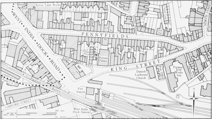
Fig. 30. Pennyfields, King Street and West India Dock Road area. Plan based on the Ordnance Survey of 1895
One of the poorest areas was a small blind courtyard named Silver Lion Court, which lay to the rear of the public house of the same name at No. 65. The Silver Lion had existed on the site from at least 1750. The court was built around 1800 and consisted of 14 backto-back, two-storey brick houses with frontages of 13ft (Plate 18a). (fn. 20) In 1862 the Medical Officer of Health reported to the Poplar Board of Guardians that '113 persons live in filth and squalor on a space of 105ft by 30ft'. (fn. 21) By the 1880s the court was almost entirely populated by the Irish and had already been closed once by the sanitary authorities. In 1882 a local resident complained of the 'low and filthy class of people occupying the houses therein'. (fn. 22) Silver Lion Court was one of several areas condemned by the Borough Medical Officer of Health in 1919 (When it contained 12 houses inhabited by 45 people). (fn. 23) In 1933 Silver Lion Court was officially declared a Clearance Area (fn. 24) and in the following year the Borough Medical Officer stated that none of the seven houses was fit for human habitation. Approached via a narrow court, the houses were described as 'dark, damp, worn-out, and dilapidated'. (fn. 25) All of them had been cleared by 1937. (fn. 26)
From the 1890s the Chinese community in the East End grew in size and spread eastwards, from the original settlement in Limehouse Causeway, into Pennyfields. The area provided for the Lascar, Chinese and Japanese sailors working the Oriental routes into the Port of London. The main attractions for these men were the opium dens, hidden behind shops in Limehouse and Poplar, and also the availability of prostitutes, Chinese grocers, restaurants and seamen's lodging-houses. Hostility from British sailors and the inability of many Chinese to speak English fostered a distinct racial segregation and concentrated more and more Chinese into Pennyfields. Gradually the drab shops of Pennyfields were transformed into Chinese emporia and their colourful interiors became an exotic contrast to the grey streets of Poplar: 'The Chinese shops are the quaintest places imaginable. Their walls decorated with red and orange papers, covered with Chinese writing indicating the "chop" or style of the firm, or some such announcement. There is also sure to be a map of China and a hanging Chinese Almanac.' (fn. 27)
The heady smells of burning opium, joss-sticks and tobacco smoked through the hubble-bubble, produced an atmosphere much sought after by the literary and artistic coterie of fin-de-siècle London. Pennyfields became a 'sight' for West End society. From the 1890s until the 1920s, parties regularly went east at night, expecting to find the unusual and morally degenerate in Pennyfields. Instead they found a commonplace street (Plate 16b). The Pennyfields of legend was always more exciting than that of reality. But it was different from the rest of Poplar: 'In the darkness of Pennyfields dark faced men are passing. Over the restaurants and shops are Chinese names.' (fn. 28)
By 1918 the number of Chinese living in Pennyfields totalled 182; all were men, nine of them had English wives. (fn. 29) At its maximum size during the 1930s, Chinatown (which included Limehouse Causeway) consisted of 5,000 persons, many of whom were sailors. A few Chinese remained in Pennyfields until the demolition of the street after 1960. (fn. 30) As early as the 1920s, many of the houses occupied by the Chinese were described as 'very old and in many cases extremely dilapidated externally'. Internally most were clean, uncrowded, vermin-free and less susceptible to infectious disease than their English neighbours. (fn. 31)
In September 1933 Poplar Borough Council declared just four houses in Pennyfields a clearance area (Nos 71– 77, odd). According to the Borough's Medical Officer, Nos 71–75 also had small shops with dark rooms. He considered that the houses were badly arranged and that they were dark at the back owing to their confined yards; behind No. 77, a three-storey building, was a roofed-in space. The timber in all the properties was tending to decay, making the floors uneven. The Deputy Borough Surveyor said that the houses were structurally very old, were worn out, dilapidated and damp, and there were signs of settlement. The rear walls were bulging, but when asked if the condition was dangerous, he replied laconically, 'not so they would fall down; they prop each other up'. (fn. 32) All of the houses concerned had been cleared away by 1937. (fn. 33)
There was some bomb damage to properties in Pennyfields during the Second World War. But by that date much of the street had already fallen into decay and many houses were in a very poor condition. During the 1950s and 1960s both sides of the street were compulsorily purchased by the LCC, with the exception of the Rose and Crown public house on the north side, which was rebuilt in the 1950s and still stands. All the other properties were demolished during the 1960s, to allow the building of the Birchfield Estate. (fn. 34)