Survey of London: Volumes 43 and 44, Poplar, Blackwall and Isle of Dogs. Originally published by London County Council, London, 1994.
This free content was digitised by double rekeying. All rights reserved.
'East India Dock Road, North side: Poplar Hospital, Nos 305-479 (dem.) and All Hallows' Church', in Survey of London: Volumes 43 and 44, Poplar, Blackwall and Isle of Dogs, ed. Hermione Hobhouse (London, 1994), British History Online https://www.british-history.ac.uk/survey-london/vols43-4/pp147-153 [accessed 30 April 2025].
'East India Dock Road, North side: Poplar Hospital, Nos 305-479 (dem.) and All Hallows' Church', in Survey of London: Volumes 43 and 44, Poplar, Blackwall and Isle of Dogs. Edited by Hermione Hobhouse (London, 1994), British History Online, accessed April 30, 2025, https://www.british-history.ac.uk/survey-london/vols43-4/pp147-153.
"East India Dock Road, North side: Poplar Hospital, Nos 305-479 (dem.) and All Hallows' Church". Survey of London: Volumes 43 and 44, Poplar, Blackwall and Isle of Dogs. Ed. Hermione Hobhouse (London, 1994), British History Online. Web. 30 April 2025. https://www.british-history.ac.uk/survey-london/vols43-4/pp147-153.
In this section
Poplar Hospital (demolished)
This building still retained at its demolition in 1981–2 some features of the hospital opened in 1855 and, probably, of the first building on the site, erected in 1806–7 as a tavern (figs 43, 44).
The East India Dock Tavern was built by a licensed victualler, Thomas Grover of Bethnal Green, on a site at the east corner of East India Dock Road and Quag Lane (Brunswick Road), offered to him by the East India Dock Company on condition that he gave the company's officers and employees and the officers of the Customs and Excise service at the dock priority of access to the tavern's best accommodation. (fn. 4) Grover's architect was George Goldring. It was a large tavern, which, owing to the elevation of the newly made road above the ground where it was to stand, had two levels of basement: a 'basement' so called and below that a cellar. The ground floor was probably raised above street level, and above that was a first floor and an attic storey. At the front Goldring evidently used decorative 'recesses' on the example of the East India Dock Company's own Dock Master's house, which he credited to the company's surveyor, Thomas Swithin. The latter was, however, severely condemnatory of Goldring's construction while the tavern was in progress: the brick walls were too thin (and further weakened by the 'recesses'); the bricks, made by the East India Dock Company itself, were fit only for use (as they were employed by the Company) for 'backing' in massive dock walls; there was a want of load-bearing partitions; the timber scantlings were inadequate; and the end of a wooden 'girder' was at one point housed over a window, 'contrary to every rule of sound building'. Goldring protested that this girder was adequately supported by 'a strong Bressummer and story Post', but he and Grover had to base their rejoinders chiefly on the need for economy in a commercial undertaking (fn. 1). Some compromise was evidently reached as the lease, for 60 years from 1807 at £10 per annum, was granted in January 1808. (fn. 5)
Grover soon found that he could not make the tavern pay and in 1811 the lease was transferred to creditors, the brewers Meux, Reid & Wigram, who gave up in 1816 (transferring the name to what became the Dock House tavern at No. 293), when the house was bought by the Commissioners of Customs for their own use. (fn. 6) The building remained a Customs House until the late 1830s, being subsequently replaced by one within the dock walls, and the freehold was surrendered in 1844. (fn. 7)
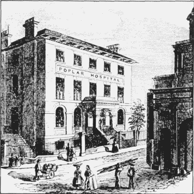
Poplar Hospital, East India Dock Road, south front in 1858. Demolished
In 1850 the building was a 'Depot for 'migrants'. (fn. 8) In 1854, however, a committee for establishing a hospital and dispensary approached the dock company and was granted a lease. (fn. 9)
The hospital opened in 1855, under the patronage of Samuel Gurney, MP, and others, chiefly to treat victims of accidents at the docks. There had been no complete rebuilding of the tavern, although the top storey may have been, as the porch probably was, an addition (fig. 43). (fn. 10) Disregarding this, the front was a five-bay lateGeorgian composition, with round-headed ground-floor windows in round-headed recesses linked by a continuous impost-band, and the first-floor level marked by a bandcourse which served as a sill-band to the straight-headed first-floor windows.
The decline of dock business was reflected in 1870 in a fall in the number of casualties needing treatment, and some medical cases were admitted. (fn. 11) In 1874, however, it was thought necessary to gain more accommodation within the hospital by renting an adjacent house to provide 'dormitories' for nursing staff. (fn. 12) The first major extension, projected in 1875, was realized in 1880–1, when a wing, mainly for out-patients' use, was added on the west side at a cost of about £2,500. The work was done by a builder nearby, Joseph Holland, to designs by the architects Manning & Baynes. (fn. 13) The five-bay East India Dock Road front was extended westward by two bays composed on the same late-Georgian pattern. Perhaps it was at this time that the overhanging eaves of the old building were replaced by battlements extending over the two new bays. (fn. 14)
In 1886 the freehold of the site was bought by the hospital from the East and West India Dock Company for £2,500 and in 1890 two houses were bought in East India Dock Road. (fn. 15) By then the land east and north of the hospital was becoming densely populated and the committee, acting for the governors (among whom local working men were well represented), was aware of the need for expansion. A ward for women casualties seemed particularly necessary. In 1890 the committee asked for plans from Rowland Plumbe (1838–1919), architect to the London Hospital, (fn. 16) but funds were insufficient, and the administration and staffing of the hospital seem not to have inspired confidence. A new approach was needed and this came about in 1891 when Sydney Holland, later 2nd Viscount Knutsford, visited the hospital as a director of the East and West India Dock Company. He disliked what he saw and had himself put in charge of a committee of enquiry. He turned out the old nursing staff, became chairman of the hospital and, by his skill in attracting contributions from the 'West End', launched a building programme for which the old committee had in truth partly prepared the ground. (fn. 17)
Between 1891 and 1894 a new wing with three floors of wards was added on the east side of the hospital, where the curtilage now extended over the former Nos 305–309 East India Dock Road. This was to designs by the committee's prospective architect, Plumbe, executed by the Limehouse builders Harris & Wardrop. A closely detailed but sober four-storeyed brick building, it had an out-patients' department in the basement and gave some provision for women (as well as children) in the wards. The old building was adapted mainly for staff residence and a conservatory erected over the porch. (fn. 18) The cost of it all was upward of £22,300. (fn. 19)
In 1892 Queen Victoria herself had become an annual subscriber and life-governor, and the great increase in contributions (£7,706 in 1889 and 1890, £32,275 in 1899 and 1900) funded further extension. (fn. 20) An isolation block was built at the back (fn. 21) and in 1899 Plumbe designed a further large eastward wing of wards on the site of Nos 311–315 East India Dock Road, purchased with £4,200 given by the Drapers' Company, which also contributed £10,000 towards the cost of building (Plate 23b). (fn. 22) The builders in 1900–2 were perhaps Harris & Wardrop (as they continued to work for the hospital). At the junction with the 1891–4 block the new brick-and-stone wing rose five-and-a-half storeys to a curved and broken gable, while at its east end a polygonal tower finished in a flat railed roof under a quirky open pavilion pierced by a chimneystack. (fn. 23)
Various further works were done or planned before the First World War. (Two contrasting aspects of the age reflected in calls on the hospital's resources in 1910 were children's dental care newly undertaken for the LCC, and the treatment of 345 accidents occasioned by the building of the Thunderer, a Dreadnought-class battleship at the Thames Iron Works.) (fn. 24)
After the war rebuilding took place in two phases, in 1922–9 and 1934–5, and was chiefly on the Brunswick Road frontage and at the rear, where the curtilage was extended to take in the sites of Nos 33–41 (odd) Athol Street.
In 1922–9 the westernmost two-bay wing erected in 1880–1 was rebuilt, a new mortuary and a large nurses' hostel erected at the rear (both by Harris & Wardrop), and a new children's ward created — the last, at least, designed by the hospital's architect, J. G. Oakley. The children's ward was largely paid for by the estate of the deceased daughter of Charles Hack, who had been a local builder and developer (and who, with his father William, had overcharged the East and West India Dock Company for contractor's work in 1852–61 to the extent of some £12,200) (see page 260). (fn. 25). The total cost of all this expansion was said to be £80,000. (fn. 26) In 1929 a new operating theatre replaced one 30 years old. (fn. 27)
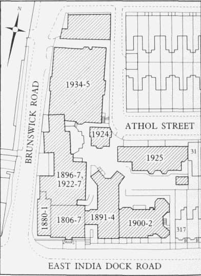
Poplar Hospital, East India Dock Road. Site planshowing the main phases of development. Based on theOrdnance Survey of 1937
In 1934–5 a large out-patients' department, half the cost of which was paid by the trustees of the cigarette millionaire, Bernard Baron, was built extending northward along the Brunswick Road frontage. The design, in a rather curt modern Georgian, was by Oakley and the builders were Walter Lawrence & Son at a contract price of £22,159. (fn. 28) By 1936–7 these changes had added a storey to the 1891–4 wing and had supplied the original building with brick-and-stone segmental-headed features to its crowning parapet. (fn. 29)
The hospital suffered a direct hit in May 1941, was closed in 1975, and demolished in 1981–2.
Nos 305–479 (demolished)
The houses built east of Poplar Hospital, none of which survives on the road frontage, were notable for their uniformity in a large development that took 20 years to complete under two distinct ownerships. The architectural expression was, in a minimalist way, regular and orderly. The hinterland northward, called the Bromley Marsh or Bromley Hall estate, extended north-eastward of Brunswick Road to what became the Poplar gasworks and also west of Brunswick Road: it was completed over an even greater span of years, and was even more uniform.
The whole area northward from the East India Dock Road had been bought in 1813 by the contractor and excavator, Hugh McIntosh, from the East India Dock Company, his main employers. (fn. 30) Except for a crescent of four pairs of semi-detached houses built on the north side of the road near the Iron Bridge about 1824–6 (fn. 31) called Lea Place (and omitted from the 1871 enumeration of East India Dock Road), this area for many years remained in agricultural use, with the extensive buildings of McIntosh's farm at the northern end of McIntosh's Lane, (fn. 32) and one or two humbler cottages nearer the road. (fn. 33) McIntosh's son David, civil engineer and contractor, of Bloomsbury, was perhaps mindful of prospective developments eastward as well as westward of the Lea, and had sufficient thought of building here in 1849 to have a clause inserted in the Commercial Roads Continuation Act requiring the trustees of the road to widen it by three feet on the north side if he did so. (fn. 34) It was, however, only with Hugh McIntosh's grandson David that development of this property in streets of houses began about 1861, when a demand for workers' houses was created by the docks and factories of Canning Town as well as of Poplar.
On the East India Dock Road frontage the Iron Bridge Tavern had been built opposite Orchard (later Leamouth) Road (at the later No. 447 East India Dock Road) under a lease from the elder David McIntosh in 1852. (fn. 35) But house-building began, under leases from his son, at No. 305, only in 1864, and had reached No. 375 by about 1872. (fn. 36) In 1873 McIntosh sold his property eastward to a manufacturing chemist John Abbott, of the firm of Forbes & Abbott, whose works were at the Iceland Wharf Works, Old Ford Road. (fn. 37) Abbott carried the houses eastward (except for one or two houses and the Iron Bridge Tavern already built by the McIntoshes) to No. 479 by about 1885, (fn. 38) with some slight changes in their planning but essentially unaltered elevations. Development of the hinterland went on for some years afterwards. (fn. 39)
McIntosh had made some mortgages of all or large parts of his property, some at least to a banker in Lombard Street, R. B. Lloyd, (fn. 40) but the closest connection was evidently with a firm of solicitors in Old Broad Street, T. Paine & T. E. Layton, who under McIntosh's will became trustees for his estate on his death in 1881. (fn. 41)
The leases of Nos 305–355 were made variously to building tradesmen and 'laymen', the latter mostly not intending occupants. The former, all of Poplar, Limehouse or Bromley in 1864–5, included George Jackson, a joiner, Henry Shepherd, plasterer and glazier, and G. J. Tanner, builder. (fn. 42) Eastward of Aberfeldy Street, the tavern on the corner (Nos 357–359) and Nos 361– 375 were all constructed about 1866–71 under long lease by G. J. Watts, builder, who himself occupied No. 375. (fn. 43) (He later, as a 'gentleman', moved to Bromley in Kent: he had enough confidence in his handiwork and its future to buy the freehold of Nos 357–375 in 1882, subject to or merging with his own long leases, for £1,810 from McIntosh's trustees.) (fn. 44)
The McIntoshes' ground rents from Nos 305–375 amounted to £167 10s per annum. (fn. 45) David McIntosh's leases give an impression of conventional regularity. They contained the usual covenants regarding the avoidance of nuisance, and in at least one instance, in a back street of the estate, were accompanied by detailed if unremarkable specifications respecting construction. (fn. 46) They were for 90 (or very occasionally 99) years from Midsummer 1857 or 1866. In the hinterland some leases were from 1872. There, in Brunswick Road and in Aberfeldy, Athol and Culloden Streets and, west of Brunswick Road, in Dewberry, Spey, Teviot and Wyvis Streets, many building tradesmen were given leases: one 'layman' who took a number of leases here was an estate agent, Samuel Mayes of Fenchurch Street, who acquired premises at No. 307 East India Dock Road as manager of the Richard Green Building and Investment Society, which interested itself in the McIntosh property. (fn. 47)
One or two premises in East India Dock Road were purpose-built for non-residential use, such as the dining-rooms at No. 305 and coffee-rooms at No. 361 (fig. 45c–d). (fn. 48) Adjacent to the latter, the Aberfeldy Tavern at Nos 357–359 was built by G. J. Watts in 1865– 6: its old-fashioned plan contained a bar, bar parlour and taproom (fig. 45b). (fn. 49) The boom in tavern-business is reflected in the £5,500 paid by the publican for the freehold in 1892. (fn. 50)
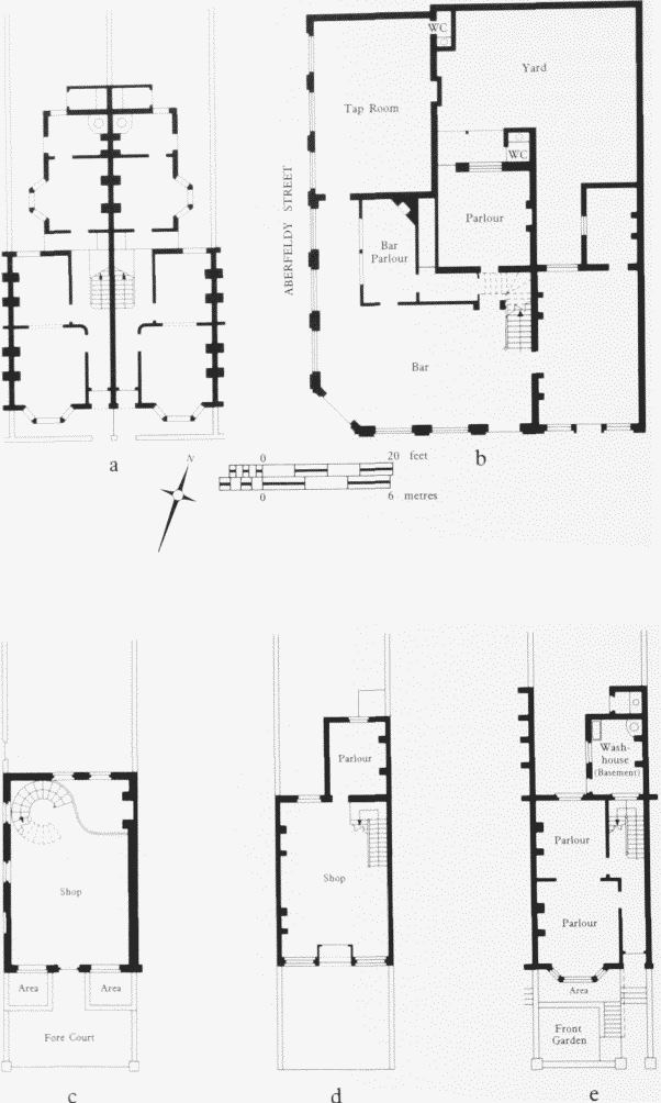
Ground-floor plans of buildings erected on the McIntosh Estate, East India Dock Road, 1864–71. All demolished Key: a Nos 51–53 (odd) Culloden Street: b The Aberfeldy Tavern, Nos 357–359 (odd) East India Dock Road: c No. 305 East India Dock Road: d No. 361 East India Dock Road: e No. 343 East India Dock Road
Mostly, however, these were small terraced houses, the arrangement of which was conventional, modified only by the unusually high elevation of East India Dock Road above the natural ground level of old Bromley Marsh. At each house a shallow forecourt contained steps up to the ground floor, where there was a front and back parlour to one side of the staircase corridor (fig. 45e). Steps down into an area gave access to the basement, which at the rear ran out into ground-level wash-houses and water closets. (fn. 51) This arrangement was repeated, not mirrored, in adjacent houses, all the houses having their front doors and rear extensions on the east.
In the hinterland the streets were more on a level with the natural surface. The terraced houses there, of mirrored plans, were without basements, and the three principal rooms on their ground floors included a relatively good-sized kitchen (fig. 45a). (fn. 52) If the overall dimensions had been greater this disposal of rooms, when in single occupation, would have had a certain amplitude to it. (fn. 2)
The architect or surveyor who supervised the estate is not known, although his formulae were followed over all the area immediately northward from this part of East India Dock Road for many years. In the later stages of the work, for John Abbott, from 1878 until 1914, the supervision was in the hands of Charles Dunch, an architect in the City, who in the 1850s had been District Surveyor for Limehouse, and his architect son of the same name, who died in 1935. (fn. 53) Perhaps the elder Dunch had originated the architectural scheme, but his name does not occur in connection with McIntosh's leases. Whoever the architect was, his elevations to East India Dock Road were rather pleasingly simple — perhaps merely by default, however, to save costs. (fn. 54) The twostoreyed stock-brick fronts, uninterrupted by any indications of the party walls, had canted bays, containing unmoulded window-openings, projecting under shallow roofs from the ground floor, and unmoulded door-openings under concave, bracketed, door-hoods. On the first floor were regularly spaced windows in plainly moulded architraves. Drain-pipes punctuated the front, which was finished by the long unbroken line of a block cornice and parapet. This did not conceal the mansard roof, the front slope of which contained a central, segmental-headed dormer to each house. The mansard shape was emphasized by the conformity to it of the party walls which rose above the roof line. This simple scheme was carried through the 600 yards of this stretch of road, modified only by the introduction, east of No. 413, of mirrored plans.
John Abbott, on acquiring David McIntosh's estate in 1873, immediately sold part of it next to the Lea to the Commercial Gas Company, (fn. 54) which built its Poplar gasworks there, adding to the demand for workers' houses (if damaging their amenities). In about 1875–7 Abbott was leasing house-plots in this hinterland for 99 years from Midsummer 1874. (fn. 56) In this hinterland two recurrent lessees were W. F. James, a rent-collector of Forest Hill, and the House Property & Investment Company in the City.
In 1878 Abbott took up the continuation of the East India Dock Road frontage eastward, when Charles Dunch applied to have houses built at Nos 379–405. (fn. 57) On Abbott's estate the use of one builder for each run of houses was evidently favoured and here John Saunders of South Hackney was the builder, being party to the grants of leases to others in 1880–1. (fn. 58) These houses were probably of essentially the same plan as their predecessors, all the entrance passages being on the east.
On either side of Benledi Street were some houses already built under McIntosh, but eastward Nos 415 445 were built in about 1881 by Charles H. Stewart of Chigwell. (fn. 59) The individual plans were similar to those previously used, but one change was introduced — perhaps for reasons related to the fact that houses were now extending beyond those adumbrated on McIntosh's first application in 1864. Hitherto the plans were repetitive, but from No. 415 eastward they were mirrored. The front elevations necessarily reflected this but were otherwise unaltered.
No. 445 was evidently purpose-built for occupation as a 'carman's' office, with stables behind. (fn. 60) East of this was All Hallows church (see below) not built as an 'estate' church, but nevertheless a project to which John Abbott gave £500 and provided the site for purchase.
Eastward again the Iron Bridge Tavern, of about 1852, (fn. 61) was much extended for the publican in 1883 at a tendered price of £2,264, to designs by the architect George T. Tribe, who lived at No. 403. (fn. 62) It was rebuilt for Messrs Taylor, Walker in 1934–5 to designs by the architect S. A. S. Yeo, with no fewer than six bars and an off-licence at the back. (fn. 63) Again rebuilt, it was in 1990 the Inner London Hotel.
The houses at Nos 449–479 were built in 1885, again by a single building concern, W. Hudson & D. T. Baker, whose premises were adjacent in Abbott Road (Plate 29d). The architect G. T. Tribe made the building and drainage applications. (fn. 64) In 1882 it had been proposed to build one-storey shops in front of all of these houses, (fn. 65) but in the end the established formula was modified only to accommodate purpose-built shops at No. 449 (a ham and beef shop) and Nos 471–479 at the corner of Abbott Road. (fn. 66) These houses east of the Iron Bridge public house were demolished and the forecourt of the public house and the churchyard of All Hallows reduced in extent by the LCC in 1912 to widen the road. (fn. 67)
All Hallows Church (demolished)
The origins of this church were in a mission curacy established by Winchester College in 1876 within the parish of St Michael and All Angels. This was a part of the ancient parish of Bromley St Leonard's that had greatly increased its population — from 8,000 to 20,000 in the last ten years, it was said — largely through the house-building activities of David McIntosh and John Abbott nearby. It was an entirely working-class area — 'seafaring men, dock labourers, gas makers' — and included some 2,000 of 'the poorest classes, living from day to day as best they can'. All Hallows was thus very different in its sponsorship from the 'estate church' of a 'residential' area, although the freeholder, John Abbott, did give £500 towards the cost of a parsonage. (fn. 68)
Abbott sold the site for £2,700 in June 1878 to Sir E. H. Currie, a large local employer, and Dr Redding, the headmaster of Winchester, who in 1879 handed it on, less the parsonage site, to the Ecclesiastical Commissioners. (fn. 69) The new parish, containing about 10,000 inhabitants, was constituted that summer, and in November the foundation stone was laid by Lord Selborne. (fn. 70) The church was consecrated by the suffragan Bishop of Bedford on Michaelmas Day 1880. (fn. 71) The cost, less the site, was £11,600, of which £9,000 was provided out of the proceeds of the sale of the site of All Hallows, Bread Street, in the City. (fn. 72)
Dr Redding would have liked the church to have been designed by Winchester College's architect, William Butterfield, who had already made a 'ground plan' of the church — 'he is so good and careful' — but the Ecclesiastical Commissioners went ahead with their own architect, Ewan Christian (1814–95). (fn. 73) (fn. 3) His builder was George Shaw of Westminster.
The site of the church was (and is) noticeably sunken below the level of the roadway. Christian placed the building well back from the road to give better light and less noise, but encountered problems with the foundations, which were 'the worst description of Thames mud' and which he identified as 'the old foreshore'. This increased the cost by £1,847. (fn. 74)
The church measured 111ft by 63ft and was 51ft high internally, accommodating 900 worshippers, all sittings being free (Plate 22b, c). (fn. 75) It was in an Early English style and the plain exterior was faced with ragstone (brick would have been only £174 cheaper). The arrangement presented a nave, broad south aisle, chancel, south vestry, and low, pyramidal-capped, south-west tower (fig. 46). The two entrances, north and south, were at the west end, that from East India Dock Road giving access to the south aisle through the base of the tower, and that from Dunkeld Street directly to the nave. The latter was divided from the south aisle by an arcade springing from low circular piers. There was no north aisle, that side of the nave being rather forbiddingly bounded, like the south aisle, by high plain walling with large coupled windows above: this was to permit the construction of a school (never in fact built there) on the north side of the church. (fn. 76) The chancel extended one bay into the nave, from which it was separated by a step but not by any chancel arch or screen. The altar was raised three steps above the sanctuary. A timber hammerbeam roof extended over nave and chancel. The sanctuary was walled-off on its south side from a vestry. The organ was placed at the east end of the south aisle, and (in an old fashion) there was a gallery across the west ends of the nave and aisle. The large east window was filled with rather harsh geometrical tracery. The west windows were lancets. (fn. 77) All Hallows was not perhaps a graceful or very interesting building but it was cited quite prominently among Christian's large oeuvre at his death. (fn. 78)
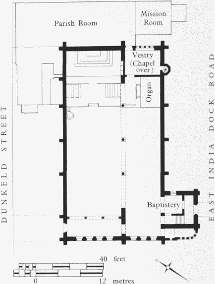
All Hallows Church, East India Dock Road, plan in 1895. Ewan Christian, architect, 1879–80
Several fittings were from the demolished church of All Hallows, Bread Street, including the pulpit, set against the north wall of the nave, some wooden panelling and carving, (fn. 79) the organ, rebuilt in 1892 under the supervision of the architect E. P. Warren (1856–1937) by Messrs Kirkland of Holloway at a tendered price of £555, (fn. 80) and the great wooden segmental-headed Corinthian reredos, probably installed in 1902. (fn. 81) In 1887 an oak reredos had been erected behind the altar to Warren's designs, and carved by a Mr Godbold of Harlestone (Northamptonshire), with figure-panels painted by C. F. M. Cleverly. The walls and roof of the sanctuary were painted by A. Gibbon of Clapham. (fn. 82) Perhaps about this time the chancel and sanctuary were raised. Warren supervised decoration of the chancel and nave walls by H. A. Bernard Smith between 1889 and 1892. (fn. 83) A wooden side altar designed by F. Bacon of Clapham, architect, was set up in 1902 at the east end of the south aisle against the west side of the organ case. (fn. 84)
In 1912–13 a chapel was formed over the apartment on the south side of the sanctuary, to designs by the architect J. Harold Gibbons (builders Ashby Brothers). An elaborate composition in timber, it set the southfacing altar against a retable and a reredos which rose to a canopy and was continued forward in wings stopped by square piers surmounted by carved figures. The central panel of the reredos was carved in low relief by Dorothy Rope. Some panelling and carving from Bread Street was also incorporated. (fn. 85)
The gaunt north and south walls were decorated in 1925 by paintings in fresco on the south wall, by Miss E. Dodgson, and oil on canvas on the north wall, by Daphne Pollen née Baring. This initiative of the vicar's was supported by Henry Tonks, Slade Professor of Fine Art, who was particularly keen on the use of fresco as 'undoubtedly the finest medium for wall decoration', but was not entirely welcomed by the congregation. The painting on the south wall was 'strongly criticized by most people' and that on the south side was apparently regarded as 'more bizarre and unsuitable than the other'. (fn. 86) By 1921 it had, however, been possible for one of the worshippers to say that All Hallows had been 'gradually progressing under each succeeding vicar until . . . they really and truly had given to them the Catholic Faith in all its fullness and beauty', and by 1934 the Sunday services included 'High Mass'. (fn. 87)
The parish room and mission room eastward of the church were built in 1884–5 to designs by J. D. Sedding (1839–91), (fn. 88) but the vicarage or clergy-house was built west of the church only in 1911 (architects, Heazell & Sons of Nottingham: builder, J. W. Jerram of West Ham, who tendered at £1,975). This was an old-fashioned building with big pitched roof and gablet. (fn. 89)
The church was badly damaged in the Second World War and was demolished in 1952. (fn. 90) A short length of iron railings and the steps down from East India Dock Road survived in 1993. It was thereafter represented by the church of St Nicholas and All Hallows in Aberfeldy Street, opened in 1955 (fn. 91) and by 1990 itself closed.