Survey of London: Volumes 43 and 44, Poplar, Blackwall and Isle of Dogs. Originally published by London County Council, London, 1994.
This free content was digitised by double rekeying. All rights reserved.
'Poplar New Town: Introduction', in Survey of London: Volumes 43 and 44, Poplar, Blackwall and Isle of Dogs, ed. Hermione Hobhouse (London, 1994), British History Online https://www.british-history.ac.uk/survey-london/vols43-4/pp200-202 [accessed 30 April 2025].
'Poplar New Town: Introduction', in Survey of London: Volumes 43 and 44, Poplar, Blackwall and Isle of Dogs. Edited by Hermione Hobhouse (London, 1994), British History Online, accessed April 30, 2025, https://www.british-history.ac.uk/survey-london/vols43-4/pp200-202.
"Poplar New Town: Introduction". Survey of London: Volumes 43 and 44, Poplar, Blackwall and Isle of Dogs. Ed. Hermione Hobhouse (London, 1994), British History Online. Web. 30 April 2025. https://www.british-history.ac.uk/survey-london/vols43-4/pp200-202.
CHAPTER VIII - Poplar New Town
The part of the parish north of the East India Dock Road was commonly known as Poplar Fields until it was renamed Poplar New Town in the 1830s. In the early nineteenth century the land was largely given over to market gardening and pasture, (fn. 2) apart from a potash manufactory between Upper North Street and the 'common sewer' which drained the area. Development of the district east of the sewer began during the 1820s, but the major phase followed the release of the remainder of the area for building from the mid-1840s. In 1856 it was said that 'within the last three or four years ... buildings have been carried on with rapidity, equalled, perhaps, by no suburban district of the metropolis'. (fn. 3) The whole area was developed by the 1870s. The name 'New Town' was in use by 1836 (fn. 4) and was applied generally to all the developments north of the East India Dock Road, but also, more specifically, to those streets within the ecclesiastical district of St Saviour's (fig. 71). (fn. 5)
Upper North Street coincided with property boundaries for much of its length. There were five ownerships along its west side by the mid-1840s.
At the southern end John W. Perry Watlington, the nephew and heir of John Perry, laid out Margaret Street (from 1876 Swale Street) in 1851, and two dozen houses were built there within the next few years (see page 132). (fn. 6)
To the north of Perry's land lay an area acquired by the brothers Oliver and George Evan Evans, and enfranchised by them in 1845. They set out Evans Street, and divided the land between them in 1846. (fn. 7) Building continued until the mid-1850s. (fn. 8) The street initially extended for 550ft to the western boundary of the Evans' land, but it was extended c1858 when Pekin Street, together with Nankin Street, was laid out by Stephen Redman and the other owners of the adjoining ground, giving Evans Street access to East India Dock Road (see page 131). (fn. 9) The whole street was renamed Pekin Street in 1887.
The Elim chapel was erected on the west side of Pekin Street in 1883 by the builder W. Howard of Canning Town for a Strict Baptist congregation from Waterloo Street in Limehouse. (fn. 10) The building could seat 300, but by 1902 attendances at services filled less than a third of the places. (fn. 11) In 1927 arrangements were made to sell the site, and the chapel was replaced by the Beulah Gospel Hall and the Excelsior Works of Ernest Perrett Ltd, flagmakers, both of which were badly bomb-damaged in the Second World War. (fn. 12)
There may have been some collaboration between the Evans brothers and James Gates, the owner of the ground on the Evans' north side, for he enfranchised his land there on the same day as they did. (fn. 13) Moreover, a short street, Randall's Buildings, was set out to connect their two streets. Gates auctioned building lots in Gates Street in 1846 and had sold all those along its southern side by 1847, when he began to dispose of those on its north side. (fn. 14) By 1850 there were 37 houses in the street and by 1855 there were 54 houses, a public house, and the Roman Catholic church of SS Mary and Joseph. (fn. 15) The street continued westward into Canton Street on the Conant estate, and the whole length was designated Canton Street in 1873.
Gates was a contractor who had operated in Poplar for many years in partnership with Thomas Horne, who owned four acres on the north side of Gates's land. Horne died in 1846, and his widow subsequently married Andrew Hind, a local grocer. Horne's death may have delayed the development of his estate slightly, but by the end of 1848 the necessary arrangements had been made. The first of at least 125 building lots on the newly set out Thomas and Hind Streets, and along Upper North Street, were being sold in 1849. (fn. 16) Building was slow, with only 26 houses completed in Thomas Street by 1855 and 37 by 1863, while the housing in Hind Street was not begun until 1854, and there were only 17 houses by 1863. Eventually, there were 116 houses in Thomas Street (renamed Gough Street, the name of its western extension), Hind Street and that part of Upper North Street owned by the Hinds, and nine in Paris Terrace, which marked the western boundary of the estate. (fn. 17) In addition, the Poplar Poor Law Guardians took a plot in Thomas Street for an infirmary. Andrew Hind attempted to develop parts of the estate himself, but not very successfully, continuing to operate as a grocer, cheesemonger and tea-dealer, moving first to Limehouse, then to Pentonville, and by 1857, when he was declared bankrupt, to Stoke Newington. (fn. 18)
The remainder of the land to the north, as far as the Limehouse Cut, was part of the estate of Richard Redfearn Goodlad, who had inherited the freehold on the death of his father, Richard Goodlad, in 1821. It had come to Richard in 1780 as a bequest from his mother's uncle, Rear-Admiral Roger Martin of Droxford, Hampshire. (fn. 19) By the early twentieth century the estate, together with the lands at Droxford, had passed to one Major W. A. Daubeney. (fn. 20)
Although R. R. Goodlad was empowered by the terms of his father's will to grant building and repairing leases, it was not until 1850 that development began, when the land to the east of Upper North Street was acquired by Onesiphorus Randall (see page 207). The land to the west of the street was disposed of on 99-year leases in 1854 to William Wicks, a builder of Forest Gate near Stratford – who took that part of it which lay in Sussex Street, Suffolk Street and the south side of Northumberland Street – and Arthur Antoine Walter, a Limehouse solicitor, who bought all of the land to the north, except a strip close to the Limehouse Cut acquired by a James Flowers in 1850. (fn. 21)
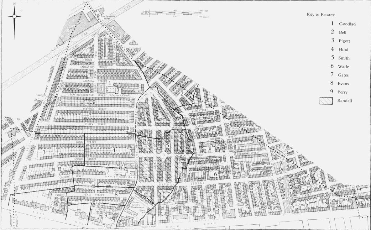
Poplar New Town. Plan based on the Ordnance Survey of 1894–6 showing division into family estates
Building in these streets proceeded fairly rapidly, both developers using a number of builders. There were c200 houses on this part of the estate by 1859 and c400 by 1868, with c550 by the end of the century. (fn. 22) (fn. 1) The estate also contained St Saviour's church and schools.
The other area west of Upper North Street developed during this period was that part of the Conant estate which lay north of East India Dock Road. The estate straddled the boundary with Limehouse, almost five acres of it being within Poplar. The development of the hinterland coincided with that of the frontages on the north side of East India Dock Road (see page 127). Stainsby Road and three streets off its eastern side were set out in the late 1840s, (fn. 24) but building along them progressed only slowly. In 1855 there were 178 building plots in Canton, Gough and Painton Streets, but only nine had been built upon, and there were 27 houses in Stainsby Road. (fn. 25) By 1864 the number of houses in the four streets had risen to 120 and by 1873 the frontages were full, with 218 houses. (fn. 26)
That part of Stainsby Road close to the East India Dock Road had some detached houses and several pairs of comfortable semi-detached villas. The remainder of the housing on the Conant estate, as upon the others, consisted of terraces of small flat-fronted brick houses, standing directly behind the pavements, generally of two and three storeys, and some with basements. There were seven public houses, comparatively few for the size of the area, and most of the shops were in Upper North Street and Stainsby Road. (fn. 27)
By the late nineteenth and early twentieth centuries parts of the district had developed a distinctly grim character. The area around St Saviour's in the north was thought to be 'the poorest part of Poplar' with 'rows of mean and small houses of that dreary sameness so usual in the East End'. (fn. 28) This was regarded as a 'very poor neighbourhood', although the streets further south were more highly thought of, with Lindfield (formerly Sussex) Street a 'fair class' street, Hind and Gough Streets of 'a good class' and Pekin and Canton Streets categorised as 'fairly comfortable', perhaps even 'very good class streets'. (fn. 29)