A History of the County of Cambridge and the Isle of Ely: Volume 8. Originally published by Victoria County History, London, 1982.
This free content was digitised by double rekeying. All rights reserved.
A P Baggs, S M Keeling, C A F Meekings, 'Thriplow hundred', in A History of the County of Cambridge and the Isle of Ely: Volume 8, ed. A P M Wright (London, 1982), British History Online https://www.british-history.ac.uk/vch/cambs/vol8/pp152-154 [accessed 30 April 2025].
A P Baggs, S M Keeling, C A F Meekings, 'Thriplow hundred', in A History of the County of Cambridge and the Isle of Ely: Volume 8. Edited by A P M Wright (London, 1982), British History Online, accessed April 30, 2025, https://www.british-history.ac.uk/vch/cambs/vol8/pp152-154.
A P Baggs, S M Keeling, C A F Meekings. "Thriplow hundred". A History of the County of Cambridge and the Isle of Ely: Volume 8. Ed. A P M Wright (London, 1982), British History Online. Web. 30 April 2025. https://www.british-history.ac.uk/vch/cambs/vol8/pp152-154.
THRIPLOW HUNDRED
The hundred of Thriplow stretches along the east bank of the river Cam or Rhee. To the south-west it is bounded by the Bran or Heydon ditch and the former Essex border, (fn. 1) where it touches one branch of the Icknield Way. In the north it crosses the river Cam or Granta, which falls into the Rhee 5 km. south of Cambridge, to extend as far as a former Roman road running south-east across the northern slope of the Gog Magog Hills. In 1066 the hundred included eight vills: Shelford, rated at 20 hides, Trumpington at 12, the eponymous Thriplow at 8, and the others, Fowlmere, Foxton, Harston, Hauxton, and Stapleford, at 10 each, making 90 hides in all. (fn. 2)
Harston and Hauxton, and the smaller village of Newton established south-east of them by the 10th century, long had their open-field land intermingled, and shared rights of intercommoning, which suggests that those three parishes, eventually distinct, were created by dividing a single, ancient unit. Newton, indeed, although it had a chapel of its own by 1150, remained attached to Hauxton ecclesiastically until 1930. It was not until 1800 that precise boundaries were defined between those three parishes and their eastern neighbour, Little Shelford. The latter, also with its own church by 1086, had been created by dividing Shelford along the line of the Granta. The names of Great and Little Shelford were recorded from 1200. (fn. 3) The separation may in both cases have been promoted by the abbot of Ely's possession, from the 10th century, of demesne manors at Great Shelford, and Hauxton and Newton. All the villages, including Newton, were treated as having separate parishes for civil purposes from the 16th century. In 1912 Trumpington was partly, and from 1934 almost entirely, absorbed into the city of Cambridge. (fn. 4)
The hundred may have taken its name, by which it was known in 1066, from a meeting place at Thriplow, perhaps on the Heath there. Later in the Middle Ages the 'accustomed place' (fn. 5) for its court to meet was probably in the more centrally sited vill of Newton: the name of 'Mutlowe' was recorded there from the 13th century. (fn. 6) Like the other Cambridgeshire hundreds Thriplow remained in the king's hands. (fn. 7) In the 13th century it was farmed under the sheriff by a bailiff who also farmed Wetherley hundred to the north-west. (fn. 8) It remained linked with Wetherley administratively in the 16th and 17th centuries. (fn. 9) In the late 13th century the bishop of Ely had view of frankpledge, with the assize of bread and of ale and a gallows, at Great Shelford and Thriplow; the prior of Ely enjoyed similar rights at Hauxton and Newton and at Stapleford, and the abbess of Chatteris, through the bishop's liberty, at Foxton. The bishop claimed also vee de naam and the return of writs. Tenants of the honor of Richmond at Foxton and Harston were drawn to that honor's general tourn for its south Cambridgeshire manors. Leet jurisdiction and the assize of bread and of ale were also enjoyed at Great Shelford and Thriplow by one other lord besides the bishop in each, and in four other parishes by one in each, and at Trumpington by two. Those two exercised their jurisdiction only in the presence of the hundred bailiff and subject to payments to him. (fn. 10)
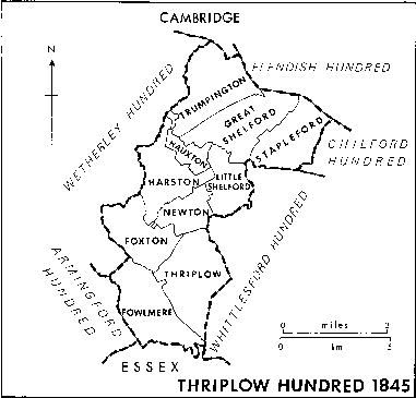
Thriplow Hundred 1845
The hundred lies mostly upon chalk, with gravel deposits along the rivers. (fn. 11) In the far south the land declines gently northward from the downs along the Icknield Way. At the north end it rises suddenly to the Gogmagog Hills, where the outer ramparts of an Iron Age hill fort survive. At those two extremities much open heathland survived until after 1800. The ground between is mostly level and low-lying, occasionally swelling into low hills. It was little wooded in historic times, but well watered. Several streams flow northwards to join the rivers, and marshland near the southwestern end was not drained until the 19th century. The area has proved well suited to arable farming. Much evidence of prehistoric and Roman habitation has been found, especially near the rivers, and also pagan Anglo-Saxon cemeteries. The villages, of which the hamlet at Newton was presumably the latest, are all nucleated. The four more southerly villages are sited near the middle of their parishes close to watercourses, beside which their main streets run. Thriplow has three parallel streets. Further north the villages mostly stand close to a river crossing, approached by a sidestreet leading from a main street roughly parallel to the river. The space between street and river is often occupied by the church and manorial homesteads.
The arable around the villages was being cultivated on a triennial rotation by the 13th century. In most villages, by the 14th century if not earlier, the furlongs or doles were grouped into three large open fields. Among the corn crops barley predominated over wheat and rye. The water meadows along the river margins permitted many milking cattle to be kept, and there were large flocks of sheep, belonging from the 16th century mainly to the manorial farms. Saffron was widely grown in the 16th and 17th centuries. In several parishes clover and grass seeds were introduced into the open-field sowings even before inclosure. Five of the six more northerly parishes were inclosed between 1800 and 1815. The sixth, Great Shelford, and the four parishes further south were inclosed after 1830, Newton, where open fields nominally survived longest, being inclosed in 1854. The area remained mainly devoted to growing corn. Sheep farming declined in the 20th century, when in some places sugar beet, vegetables, and fruit-growing were introduced.
By 1086 the two rivers were turning at least one water-mill in each parish. Sometimes used also for fulling in the later Middle Ages, the mills mostly survived as corn mills into the 19th century. The last, at Hauxton bridge, where a small settlement had grown up by the 14th century, closed in 1975. It and Great Shelford mill had flourished around 1800, grinding oilseed for animal feed. Except for woolworking at Fowlmere, ropemaking at Little Shelford recorded from the late 18th century, and a few breweries and builders' yards, the villages had few manufactures before 1900. Printing was started at Foxton in 1908 and some light engineering at Fowlmere and Great Shelford in the mid 20th century. Larger-scale works then established near Hauxton and at Harston produced agrochemicals and animal feed, while agricultural research institutions were installed at Trumpington and Newton.
The area shared in the national growth of population in the early 19th century. A decline starting in the 1850s was halted for a time, as coprolite digging in the riverine parishes from the 1860s to the 1880s provided enough employment to dissuade many labourers from emigrating. From the late 19th century the northern parishes were affected by the expansion of Cambridge. New housing first occupied the northern parts of Trumpington, then spread by ribbon building through that village and Great Shelford to submerge Stapleford from the 1960s. The numerous newcomers who swelled the population in those places mostly worked in Cambridge. Further south numbers remained stable at the lower level reached after the late Victorian decline until after 1950 when new housing estates began to be built.