A History of the County of Essex: Volume 10, Lexden Hundred (Part) Including Dedham, Earls Colne and Wivenhoe. Originally published by Victoria County History, London, 2001.
This free content was digitised by double rekeying. All rights reserved.
'East Donyland: Introduction', in A History of the County of Essex: Volume 10, Lexden Hundred (Part) Including Dedham, Earls Colne and Wivenhoe, ed. Janet Cooper (London, 2001), British History Online https://www.british-history.ac.uk/vch/essex/vol10/pp186-191 [accessed 30 April 2025].
'East Donyland: Introduction', in A History of the County of Essex: Volume 10, Lexden Hundred (Part) Including Dedham, Earls Colne and Wivenhoe. Edited by Janet Cooper (London, 2001), British History Online, accessed April 30, 2025, https://www.british-history.ac.uk/vch/essex/vol10/pp186-191.
"East Donyland: Introduction". A History of the County of Essex: Volume 10, Lexden Hundred (Part) Including Dedham, Earls Colne and Wivenhoe. Ed. Janet Cooper (London, 2001), British History Online. Web. 30 April 2025. https://www.british-history.ac.uk/vch/essex/vol10/pp186-191.
In this section
EAST DONYLAND
EAST DONYLAND lies on the west bank of the River Colne immediately south-east of Colchester borough, into which it was taken in 1974. The small, roughly rectangular, parish (1,052 a. or 426 ha.) was bounded by the Colne on the east, Roman river on the south, and Birch brook on much of the north, and the Mersea road on much of the west. (fn. 1) The village of Rowhedge stands on the bank of the Colne. A claim in the 1690s that Colchester castle bailey and the adjoining Sheepshead field were in East Donyland failed, as did the rector's attempt c. 1749 to claim tithe from Bourne pond in Colchester. (fn. 2) In 1889 two detached parts of Fingringhoe, 301 a. at Blackheath west of the Mersea road and 23 a. east of the road, were transferred to East Donyland. (fn. 3) Blackheath and a small area north of Birch brook, totalling 166 a., were transferred to Colchester in 1934. (fn. 4) In 1946 the part of Langenhoe (85 a.) north of Roman river was transferred to East Donyland. (fn. 5) In 1981 7 ha. south-west of Rowhedge Road and north of Birch brook was transferred from St. Giles's, Colchester, to East Donyland. (fn. 6)
The soil is glacial gravel and sand, with bands of alluvium and London clay along the Colne and Roman rivers, and of London clay along Birch brook. (fn. 7) Much of the alluvium is marsh, and in the centre of the parish 30 a. remained heathland in the 19th century. The land rises from below 8 m. in the river valleys and along the eastern part of Birch brook to over 30 m. at the top of Roman Hill in the north-west corner of the parish. (fn. 8)
Until 1900 the route from Colchester to Rowhedge was by Mersea Road and Weir Lane. The extension of the army firing ranges that year partially closed Weir Lane, and the road through Old Heath and Battleswick, made between 1846 and 1876, was improved to replace it. (fn. 9)
The Fingringhoe road crossed Roman river by a bridge called Millbridge in 1610 when its repair was the responsibility of the two parishes. The county repaired it in 1645, and maintained it regularly from 1664. The wooden bridge built in 1814 survived until 1923 when it was replaced by a concrete one. (fn. 10) A ferry over the Colne between Rowhedge and Wivenhoe operated from 1718 or earlier; by the 1990s it ran at summer weekends only. (fn. 11)
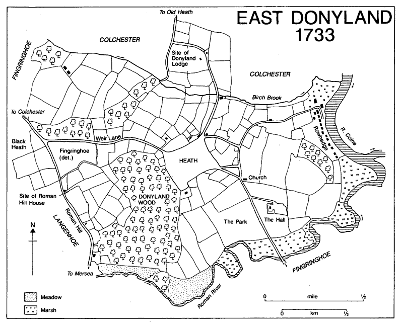
East Donyland 1733
East Donyland was outside the Iron-Age Camulodunum, but trackways with associated enclosures, seen as crop marks on the high ground in the centre and north of the parish, indicate prehistoric settlement in the area. (fn. 12) A mound in woodland east of the site of the medieval church and north-north-east of Donyland Hall might be a barrow, but is more probably part of an 18th-century garden scheme. (fn. 13)
In the late 10th century the large estate centred on Colchester which had been held by the ealdormen of Essex was broken up, and East Donyland was separated from the rest of Donyland (Dunna's or Dunning's land), which became part of Colchester. (fn. 14) In 1066 it had a recorded population of 15, presumably heads of households. (fn. 15) In 1319 and 1327 it was one of the smallest or poorest parishes in Lexden hundred, and its population and wealth were still below average for the hundred in 1525. (fn. 16)
Early medieval settlement was scattered, the most important site probably being the manorhouse and church which lay c. 474 yd. apart on the east side of the Fingringhoe road. By the 14th century a village was developing at Rowhedge (rough enclosure) on the river bank, first recorded in 1346 and certainly a settlement by 1394. (fn. 17) Rowhedge grew in the earlier 16th century, probably as its port developed, and the parish was sometimes called Much or Great Donyland (fn. 18) in contrast with the smaller Berechurch and Old Heath in West Donyland. In 1538-9 there were at least 32 houses and cottages in East Donyland. (fn. 19) In 1671 there were 51 houses in the parish, 2 of them newly built and 7 empty, (fn. 20) and in 1723 the rector reported a population of c. 50 families. (fn. 21) In 1733, of c. 40 separate buildings in the parish, 27 were in Rowhedge. (fn. 22) Although successive rectors described East Donyland as unhealthy, and funerals outnumbered baptisms in the 1730s, the early 1740s, 1754, 1768, 1780, and 1781, the population grew throughout the 18th century. (fn. 23) By 1801 it was 370. It rose steadily to 1,582, in an area which included the developing hamlet of Blackheath, in 1891. It was almost unchanged in 1901, and had fallen to 1,301 in a slightly smaller area by 1931 as yachting and shipbuilding, which were the main sources of employment, declined. The addition of land formerly in Langenhoe helped raise the population to 1,803 in 1951, but it fell again to 1,486 in 1961. As Colchester expanded and Rowhedge became almost a suburb of the town, its population rose to 1,731 in 1971 and to 2,284 (in a slightly larger area) in 1991. (fn. 24)
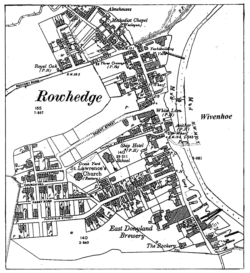
Rowhedge street plan, 1897
Rowhedge (fn. 25) consisted of a single High Street along the river bank until 1837 when the new church was built behind the river frontage. By 1840 there were five houses on the newly laid out Church Street. (fn. 26) By 1876 houses had been built in Head Street, West Street, and Chapel Street to the north of High Street, in Albion Street running west from High Street, and in the later Church Hill and Paget Road west of the church. Further streets west of High Street were developed in the late 19th century; in the 20th century the built-up area was extended along both sides of Rectory Road, between the north end of High Street and the heath. (fn. 27)
Parts of three or more substantial 16th-century houses survive along the waterfront. The south end of nos. 14-16 High Street is a 16th-century cross wing, which was originally jettied towards the quay and still has part of a crown-post roof and a rebuilt side chimney stack. To the north, presumably in place of the main range of the early house, are two 17th-century cottages, and the whole range is unified by an 18th-century brick front and roof. The central section of the Three Crowns, High Street, appears to have been a small open hall which had a hipped roof at its north end. The hip was removed in the late 16th century or the early 17th when an attic floor was put into the hall and a two-storeyed cross wing built against it. The hall range was extended southwards by a two-storeyed block in the 18th century. The southern part of Timbers, Marsh Crescent, now the centre of a row of cottages, is a 16th-century cross wing with a crown-post roof and evidence of a jetty towards the quay. Part of the much restored hall range survives to the north. Among other early houses is one on the corner of High Street and Dark House Lane, refronted in brick in the 18th century with a Doric porch. The house, which was part of Rowhedge Ironworks, may have been the Marsh House recorded from 1707; it belonged to the Tabor family and then passed, as four tenements, to the shipbuilders Samuel Cook and Daniel Cole. (fn. 28) In Chapel Street and the roads leading west from High Street are several mid or late 19th-century terraces of small brick houses, which with the older buildings were said in 1970 to give that part of the village considerable charm and character. (fn. 29) In 1976 the waterfront on High Street was laid out as a small park, and a large orbital sundial was set up there in 1978. (fn. 30)
On the western edge of the parish is the 18th-century Roman Hill Farm, formerly in Fingringhoe. A medieval brick kiln is said to have been found in the grounds of the nearby Roman Hill House. There was a building there in 1733 and a house by 1774. (fn. 31) The surviving white-brick house, of two storeys with attics, was built in 1822. (fn. 32) The nearby barn is of the later 18th century. In the 20th century the house has been occupied by senior army officers, in 1906 and 1908 by Brig.-Gen. E. H. H. Allenby who became commander of the British forces in Palestine in the First World War and was created Viscount Allenby in 1919. (fn. 33) From 1948 to 1995 it was the official residence of the general officer commanding Colchester garrison. (fn. 34)
Donyland Lodge, a two-storeyed house of painted brick with a hipped slate roof, stands on the northern boundary of the parish; it was probably built by Jacob Verlander of Colchester, its owner in 1827, or his successor, the Revd. J. J. Holroyd, on the site of an earlier farmhouse. (fn. 35)
A settlement developed at Blackheath, then in Fingringhoe parish, in the mid 19th century. In 1851 there were 18 houses there, and by 1891 c. 30, almost all on Mersea Road. The area was transferred to Colchester in 1934. Between 1977 and 1990 the former Cherry Tree army camp, in the north-west corner of East Donyland civil parish (formerly in Fingringhoe) was redeveloped as a civilian housing estate with c. 200 houses and a primary school. (fn. 36)
Middlewick farm, Colchester, bought by the War Office as a rifle range and drill ground in 1856, extended into the north-west corner of East Donyland. From 1873 the War Office leased an adjoining 62 a. which it bought in 1889. Despite local opposition, c. 443 a. in the western half of the parish, including Donyland Heath and Wood and Donyland Place farm, was bought in 1898 and 1899. The large, probably 19th-century Donyland Place was demolished, and the extended rifle range was opened in 1900. (fn. 37) It was still in use in 1994.
There were two or more victuallers in the parish in 1608, and in 1644 the parish constables tried unsuccessfully to close the Swan alehouse. (fn. 38) By 1758 there were three alehouses, the Three Crowns, the White Lion, and the Ship, (fn. 39) and the same three were recorded throughout the later 18th century and the 19th. A fourth was recorded in 1848, and in 1866 there were five, all but one in High Street on the waterfront. (fn. 40) Others opened c. 1906 and c. 1937, but two, including the Ship, closed in 1914. (fn. 41) Only three pubs, the Albion, the Anchor, and the Freemason's Arms, were open in 1994. The beer retailer recorded west of Rowhedge from 1870 was probably at the Ipswich Arms, which was still open, as the Walnut Tree, in 1994. (fn. 42)
Carriers' carts ran from Rowhedge to Colchester by 1848. A motor bus service started in 1920, and the Colchester bus routes were extended to Rowhedge in 1984. (fn. 43) The Colchester Gas Co. extended its supply to Rowhedge in 1910, and Colchester corporation provided electricity to Blackheath from 1930 and to Rowhedge from 1931. (fn. 44) Water was supplied from wells until 1902 when a borehole was sunk and a water tower with a 40,000 gallon tank built on high ground in Parkfield Street to provide a piped supply. (fn. 45) The parish council opposed plans for a sewerage system in 1897, and objected to drainage and sewerage proposals made by the Local Government Board and the Medical Officer of Health in the years before 1914, but it agreed to support a scheme in 1933. (fn. 46) There was a post office from 1878. (fn. 47)
A friendly society, called the Society of Brotherly Love in 1794, met at the Three Crowns from 1793 until 1831 or later; in 1828 its numbers were limited to 60. The Three Crowns slate club, whose 252 members were entitled to sick pay, death benefit, and an annual share-out, continued in 1902. The Ship benefit club closed in 1898, but the Albion slate club, with 133 members, and the Royal Oak slate club continued in 1910. (fn. 48) The Mariners lodge of the Oddfellows was founded at Rowhedge in 1891 and had closed by 1947. (fn. 49)
The Colchester rowing club was holding its annual regatta at Rowhedge by 1896. (fn. 50) A regatta, held in alternate years at Rowhedge and Wivenhoe by 1902, continued until 1913. (fn. 51) Rowhedge Regatta was held again from 1962 to 1979. (fn. 52) The Rowhedge Star football club was founded before 1896, and a string band and a Horticultural Society c. 1900. (fn. 53) A cricket club and a quoits club had started by 1922. (fn. 54) The War Office agreed in 1892 to provide a parish recreation ground in exchange for part of Donyland Heath, but the 7½-a. recreation ground, on the south-west edge of the village, was not opened until 1928. (fn. 55) The design of a Community Centre built there between 1982 and 1987 was commended by the Prince of Wales. (fn. 56)
Tides 26 ft. above normal spring tides caused serious flooding to low-lying areas of Rowhedge in 1906. (fn. 57) The village escaped serious damage in 1953, although there was flooding in High Street and salt water contaminated the water supply. (fn. 58) A barrier across the Colne to protect Rowhedge as well as Wivenhoe and Colchester was completed in 1994. (fn. 59)
MANOR.
Aethelflaed, widow of King Edmund and daughter of Ealdorman Aelfgar of Essex, held an 8-hide estate at Donyland which, probably between 975 and 991, she devised to four men. (fn. 60) The estate had been further divided by 1066 when Edric held 1½ hide and a freeman ½ hide, both of which were held by Eustace of Boulogne in 1086, (fn. 61) and which later formed the manor of EAST DONYLAND. The manor descended with the honor of Boulogne until between 1148 and 1152 when Maud, wife of King Stephen, exchanged it with St. John's abbey, Colchester, for the church of Lillechurch, Kent. (fn. 62)
Part of the manor, probably the ½-hide estate, was then held of Maud by Henry de Merk and of him by Geoffrey de Tregoz. In the early 13th century John de Merk held a knight's fee in East Donyland and Witham, which had passed to Andrew Blunt by 1253 when the demesne tenant was Oliver son of Ellis of Colchester. (fn. 63) By 1302, when Jordan son of Oliver conveyed it to St. John's, the land in East Donyland was held directly of the abbey. (fn. 64)
The abbey held East Donyland until the Dissolution when it escheated to the Crown. The Crown retained the manor, leasing the site to Edward Cole in 1542, (fn. 65) until 1560 when it was granted to the lessee, Sir Francis Jobson of Monkwick in Colchester. (fn. 66) Jobson died in 1573, devising East Donyland to his younger son Edward who, having reached a settlement with his elder brother John, held the manor until his death in 1590. (fn. 67) He was succeeded by his daughters Elizabeth, who died in 1601, and Mary who married George Brooke. (fn. 68)
Mary and George Brooke sold the manor between 1630 and 1634 to Sir John Tunstall of Addiscombe (Surr.), who was succeeded by his son Henry (d. 1650). (fn. 69) Henry's son John sold the manor to Edmund Thurston of Colchester in 1668. (fn. 70) Thurston died in 1669 and was succeeded by his son (d. 1690) and grandson, both called Joseph Thurston. (fn. 71) The second Joseph, who married Mary daughter of Sir Isaac Rebow of Colchester, died in 1714, and in 1718 East Donyland was sold by Edmund Raynham to Daniel Bayley of Colchester, Mary Thurston's steward. Joseph's son, a third Joseph Thurston, challenged the sale, and by 1725 had recovered at least an interest in the manor which he agreed in 1730 to sell to David Gansel of Leyton. The sale was completed in 1735 by his brother and heir Thomas Thurston and Daniel Bayley. (fn. 72)
East Donyland descended from David (d. 1753) to his son Col., later Lt.-Gen., William Gansel, who died insolvent in 1774. (fn. 73) He had devised East Donyland to Elizabeth Bowman for life with remainder to his nephew David Jebb, who held the manor in 1781, but his will was successfully challenged and in 1783 his sister Anne and her husband John Jebb released East Donyland to Nicholas Caesar Corsellis, who had acquired the mortgage interest in the manor. Corsellis agreed in 1787 to sell the manor to James Ashwell, but Ashwell had not completed the purchase when he died in 1794, and his trustees sold East Donyland that year to Philip Havens. (fn. 74) Havens held the manor until his death in 1856 when he was succeeded by his son, Philip (d. 1874). (fn. 75) Philip was followed by his son W. R. Havens (d. 1887), and his grandson E. J. Havens, both known locally for their eccentricity. (fn. 76) E. J. Havens or his trustees apparently sold the manor in 1924 to G. F. Beaumont whose trustees sold it in 1954 to W. A. Foyle. (fn. 77)
East Donyland Hall was recorded in 1463 and in 1499, but a lease in 1522 referred only to a dairy and a barn. (fn. 78) By 1542 the tenant, Edmund Troman, had erected buildings which in 1560 included a dovecot. (fn. 79) The surviving Hall abuts the western side of a large rectangular moat, but no part appears to be structurally earlier than the early 17th century, when it had a hall and cross-wing plan; it was probably built for William Gray, husband of Edward Jobson's widow Mary, who lived at East Donyland until his death in 1612. (fn. 80) The house was assessed on 17 hearths in 1662. (fn. 81) Between 1730 and 1733 the timber-framed walls were encased in brick and the space between the wings on the west side was filled in to give a continuous elevation; the work was carried out for, and probably to the plans of, the new owner David Gansel, an amateur architect. During the 18th century the central room was converted into a stair hall and much of the house was refitted. Later in the century a ballroom or drawing room was added on the north. In 1794 the house contained four parlours and a drawing room or ballroom 38 ft. by 21 ft. on the ground floor, nine bedrooms on the first floor, and servants' quarters in the attic. (fn. 82) The ballroom was demolished c. 1900. The house and outbuildings were restored in the later 1940s; the work included removing a high parapet which hid the dormer windows, and extending the east elevation by building screen walls, that to the north concealing a kitchen.
The eastern side of the moat has been filled in. Beyond its line three 18th-century outbuildings present pedimented gables to the house. Three hundred metres to the north-east an 18th-century gazebo, now in ruins, stood on a small rise, looking towards the house. In 1733 the house stood near the north-east corner of a 50-a. park, (fn. 83) but by 1839 the area west of the Fingringhoe road had been converted to arable. (fn. 84) David Gansel created a short-lived landscape park to the north of the house, incorporating the gazebo and perhaps a mound east of the medieval church. (fn. 85)