A History of the County of Essex: Volume 8. Originally published by Victoria County History, London, 1983.
This free content was digitised by double rekeying. All rights reserved.
'Parishes: Grays Thurrock', in A History of the County of Essex: Volume 8, ed. W R Powell, Beryl A Board, Nancy Briggs, J L Fisher, Vanessa A Harding, Joan Hasler, Norma Knight, Margaret Parsons( London, 1983), British History Online https://www.british-history.ac.uk/vch/essex/vol8/pp35-56 [accessed 27 July 2024].
'Parishes: Grays Thurrock', in A History of the County of Essex: Volume 8. Edited by W R Powell, Beryl A Board, Nancy Briggs, J L Fisher, Vanessa A Harding, Joan Hasler, Norma Knight, Margaret Parsons( London, 1983), British History Online, accessed July 27, 2024, https://www.british-history.ac.uk/vch/essex/vol8/pp35-56.
"Parishes: Grays Thurrock". A History of the County of Essex: Volume 8. Ed. W R Powell, Beryl A Board, Nancy Briggs, J L Fisher, Vanessa A Harding, Joan Hasler, Norma Knight, Margaret Parsons(London, 1983), , British History Online. Web. 27 July 2024. https://www.british-history.ac.uk/vch/essex/vol8/pp35-56.
In this section
GRAYS THURROCK
Grays Thurrock, usually known simply as Grays, is the main centre of the borough of Thurrock, lying beside the Thames 34 km. east of London. (fn. 1) It was formerly a small port, with chalk quarries, brickworks, and a brewery. Those occupations declined after the First World War, but have been replaced by light engineering, plastics, and packaging. The ancient parish comprised 1,382 a. (559.3 ha.), bounded north and west by Stifford and east by Little Thurrock. (fn. 2) A local board, later urban district council, was formed for the parish in 1886. In 1936 Grays Thurrock urban district was merged in the new urban district of Thurrock, which in 1974 became the borough of Thurrock. (fn. 3)
From the alluvial marshes by the river the land rises to about 25 m. above sea-level in the north of the parish. Underlying the alluvium are successive strata of Brickearth, Thanet Beds, and Upper Chalk. (fn. 4) Extensive quarrying, mainly in the 19th century, has altered the natural landscape, as well as influencing the pattern of settlement.
In 1086 Grays was a small rural manor with a recorded population of 28. (fn. 5) Twenty-four Grays men were assessed to the lay subsidy in 1327. (fn. 6) In Chafford hundred only South Weald and Aveley had more taxpayers. West Thurrock, a parish much larger in area, had the same number. This suggests that Grays was becoming urbanized by the early 14th century, but during the next three centuries it seems to have grown relatively little. The 1523 lay subsidy contains only 34 Grays names, and in 1670 there were only 38 houses in the parish. (fn. 7) At both those dates Grays was outranked by 7 parishes in the hundred. By 1801, however, it had risen to fourth place, with a population of 677. It grew steadily to 2,806 in 1871, and then more rapidly to 13, 543 in 1901, and 18, 173 in 1931, the last year for which there are separate census figures for the parish. The parish figures do not fully reflect the growth of the town of Grays, which by c. 1900 had begun to spread eastwards into Little Thurrock. In 1931 Little Thurrock had 4,428 inhabitants. In 1971 Grays and Little Thurrock wards together contained 22,815 inhabitants. (fn. 8)
The Pleistocene gravels at Grays have yielded a remarkable series of mammalian remains, including those of the wild cat, spotted hyena, wolf, bear, bison, hippopotamus, rhinoceros, and mammoth. (fn. 9) Remains of human occupation from the Palaeolithic to the Roman period have been found in the parish, (fn. 10) the Bronze Age being especially well represented. (fn. 11) Roman finds, including burials, are sufficient to suggest a substantial settlement. (fn. 12)
Medieval Grays grew up along the narrow High Street which ran north from the Thames to join the road from Purfleet to West Tilbury (now Orsett Road). As late as 1777 the built-up area of the town extended no farther north than the church. (fn. 13) Bridge Road and Argent Street already existed, though not so called. Farther east was Gipsy (now Whitehall) Lane. Hogg Lane ran north towards Stifford. Grays Hall, on the site of the ancient manor house, lay in the angle of Orsett Road and Bridge Road. By 1777 it had been succeeded as principal house in the parish by Sherfield House, which stood east of the High Street, at the southern end of town. (fn. 14)
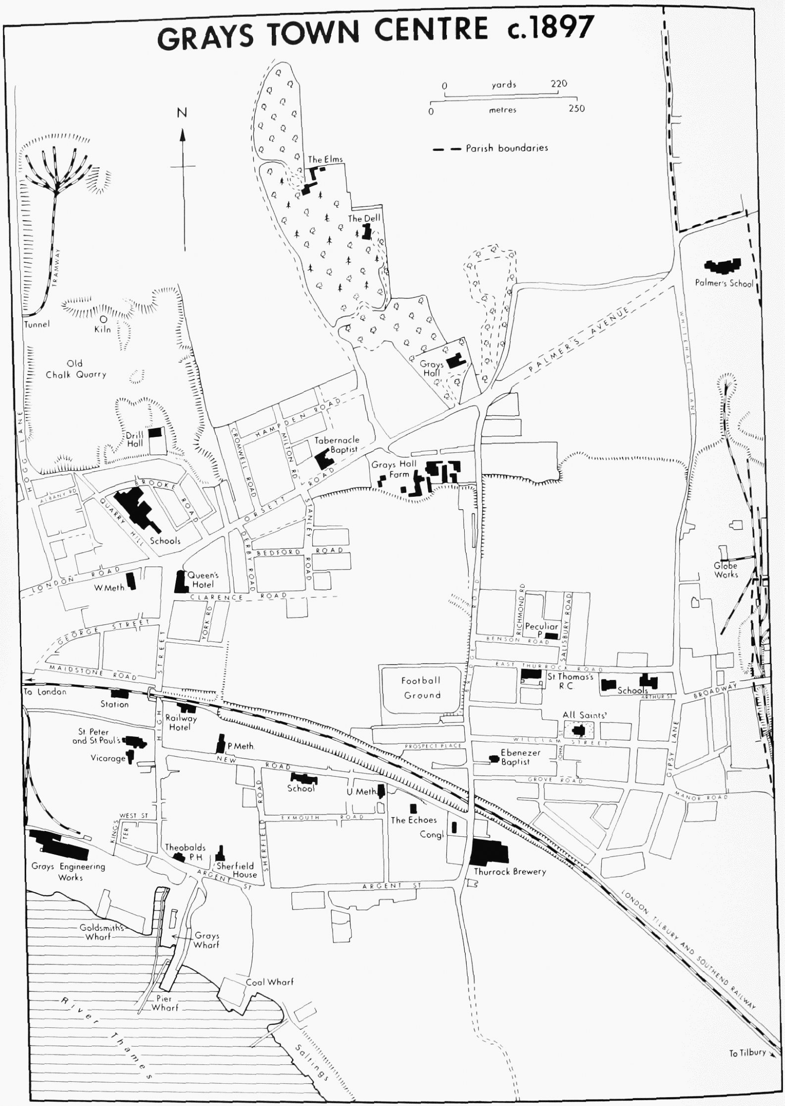
GRAYS TOWN CENTRE c. 1897
By 1843 a few terraces of cottages had been built in Orsett Road, London Road, and Argent Street for the workers in the chalk quarries and brickworks. (fn. 15) The old town was beginning to creep northwards, but most of it still lay south of the church, and it seems that most of the new inhabitants, since the 17th century, had crowded into tenements built or converted for the purpose in and behind High Street. (fn. 16) The slums thus created included some 'back-to-backs' which were not removed until c. 1928. (fn. 17) Two large houses had been built in the parish between 1777 and 1843: Belmont Castle and Duvals, both near the northern boundary.
Between 1871 and 1901 the town burst out of its ancient shell, expanding north, east, and west. Growth was stimulated by the coming of the railway, the continuing development of local industries, the opening of the neighbouring Tilbury docks, and the financial needs of the lord of the manor, James Theobald, who succeeded his father in 1871. Between 1871 and 1893 over 1,000 houses were built in the town under leases granted by Theobald. (fn. 18) Building was most rapid between 1882 and 1890. By 1895 the whole of High Street, and the adjoining areas of Orsett Road and London Road, had been built up. (fn. 19) Farther north, beyond Orsett Road, Brooke Road and Quarry Hill were complete, and building had started in Cromwell, Milton, and Hampden Roads. George Street and Maidstone Road had been laid out to the west of High Street. The main thrust of growth, however, was eastwards. Most of the area between the railway and Argent Street had been built up, including New Road and Exmouth Road. Farther east the All Saints district had sprung up as a separate township in and around East Thurrock Road, William Street, and Grove Road. Between the railway and Orsett Road there was still some open land. Until a few years earlier it had been occupied by brickfields, with a network of tramways leading to the riverside wharfs. (fn. 20) In 1895 the western end of Clarence Road already existed, and beyond Bridge Road there were a few houses in Benson, Richmond, and Salisbury Roads. By c. 1914 much of the area had been built up, thus linking the town more directly with the All Saints district. (fn. 21) Development has only partly obscured the scars on the landscape left by the brickfields. That is most obvious at the southern end of Bridge Road, which has a steep escarpment on each side.
In 1903 the town contained 2,507 houses, mostly cottages and small villas. (fn. 22) There was then great demand for working class dwellings, and they were being built at the rate of 100 a year. In the five years up to March 1905 a total of 435 new houses were certified for occupation. The pace of growth then fell sharply. By 1908 there were 200 unoccupied houses in the town, and in the 9 years up to March 1914 only 272 new ones were certified.
After the First World War the U.D.C. bought 100 a. of the Grays Hall estate, north of Orsett Road, and between 1920 and 1930 built over 500 houses. During the same period over 400 houses were erected by private builders. One of the largest private developments was the Lodge estate, north of the town. That was at first left with unmade roads and cesspool drainage, but by 1934, after pressure from the council, had been brought up to standard. By 1939, when building was again halted by war, the town had climbed northwards as far as Long Lane, and included the south-east fringe of Stifford, as well as most of Little Thurrock parish. (fn. 23)
With its valuable mineral deposits Grays might well have grown faster if it had had better communications, but until the 19th century it remained a remote marshland township. The coastal east-west road, now London Road, was in the 18th century only a local road, linking Purfleet, West Thurrock, Grays, and West Tilbury. (fn. 24) It became more important in the early 19th century, as part of the road from London via Aveley and West Thurrock to Tilbury Fort. (fn. 25) Communications in the north of the parish were not much improved until the 1920s, when the London-Southend arterial road was built, including a new section running east through Stifford to join Lodge Lane. (fn. 26) The arterial road is approached from the west by London Road and Hogg Lane, and from the east by Orsett Road, Palmers Avenue, and Southend Road. Palmers Avenue was laid out c. 1890 to bypass a section of the old road with an awkward right angled bend, and to provide a grand approach to the town. (fn. 27)
The port of Grays, with its wharfs and ferries, is described elsewhere. (fn. 28) As early as 1637 there were regular boat services between Grays and London. (fn. 29) In 1838 travellers to London could use the Gravesend river steamers, 'hailed by a boat put off Grays'. (fn. 30) From c. 1841, when Grays pier was built, the steamers called there, and by 1848 there were services five times a day. (fn. 31) In 1810 Grays was served by a coach plying between Romford and Tilbury Fort. (fn. 32) In 1838 the coach between London and Horndon-on-the-Hill passed through daily. (fn. 33) The London, Tilbury, and Southend railway was opened in 1854 as far as Tilbury, with a station at Grays, and was extended to Southend in 1856. The line passed through Grays immediately north of the town, with a level crossing in High Street. The branch from Grays to Romford was opened as far as Upminster in 1892, and in 1893 was extended to Romford, where it linked with the main line of the Great Eastern railway. (fn. 34) Grays railway station was badly damaged by bombing during the Second World War, and the 'up' (south) side was rebuilt in 1954. (fn. 35)
Grays had a postal receiving house, served from Romford, by 1838. (fn. 36) There was a telegraph office by 1874. The post office was in the High Street in the 1880s, but by 1890 had been transferred to New Road, where it remained until a new office was built in George Street c. 1930. (fn. 37)
A visitor in 1876 found 'nothing to be said for the beauty, and not much for the picturesqueness of the town. It is old, irregular, and, like all these small Thames ports, lazy-looking and dirty. (fn. 38) Few of the buildings visible in 1876 still remain. The High Street then contained several timberframed buildings of the 17th and 18th centuries, which survived until c. 1970. (fn. 39) A notable brick building there was the Dutch House, which probably dated from the late 17th or the early 18th century, and was demolished in 1950. (fn. 40) East of High Street, at the far end of New Road, was the Echoes, built c. 1869, which was for long the home of Charles Seabrooke the brewer. It was demolished in 1966. (fn. 41) In Orsett Road, opposite the site of the present central library, stood Reed Row, a long, squalid terrace of cottages, probably of the early 19th century, with a blank rear wall facing the road. (fn. 42) In 1843 it belonged to Meeson & Errington, brickmakers. (fn. 43) It was demolished in 1893. (fn. 44)
North-west of the town, on the hill above Meeson's Lane, was Belmont Castle, built c. 1795 by Zachariah Button, owner of the neighbouring chalk quarry. (fn. 45) It was designed to resemble a medieval castle, with battlements and a central tower, and stood in a park extending for ½ mile down to London Road. (fn. 46) The southern edge of the park was built over c. 1900. (fn. 47) Edward R. Parker, who lived at Belmont Castle c. 1880– 1900, was chairman of the local board. (fn. 48) The house was demolished during the Second World War. (fn. 49) Farther east, and also perched high on the hill, was Duvals, built as a farmhouse in the early 19th century. (fn. 50) It was put up for sale with 109 a. in 1837. (fn. 51) Then or soon after it was acquired by John Meeson (d. 1858) who was already quarrying chalk in the neighbourhood. (fn. 52) The Meesons lived there until c. 1880. From c. 1880 until 1928 Duvals was the home of Edmund W. Brooks, cement manufacturer, who enlarged the house in 1896. (fn. 53) In 1979 it was a hostel for old men, under the South Ockendon hospital management committee. North-east of the town, in 1876, were three big houses, all recently built: the new Grays Hall, (fn. 54) Orsett Road, and the Dell (fn. 55) and the Elms, both in Dell Road. The first two survived in 1979. The Elms, built c. 1850 in 'a fairy land, with its deep and picturesque ravine', (fn. 56) had been demolished by 1979, when the site was occupied by Treetops school.
Some visitors in the later 19th century were struck by the large number of public houses. In 1866 one even remarked that Grays 'for its size contains more than any other town in England'. (fn. 57) That may have been an exaggeration, but it is true that in 1866 there were at least 9 wellestablished public houses, i.e. one for every 122 inhabitants of the parish. It reflected the rough character of the town. As late as 1883 a newcomer found Grays a 'pretty hot shop', where revellers on 5 November rolled lighted tar barrels down High Street. (fn. 58) Eight of the public houses existing in 1866 can be traced from the 18th century or earlier. The Anchor and Hope, Old High Street, was previously the George, recorded from 1727 or earlier. (fn. 59) It was closed in 1960 and demolished c. 1970. (fn. 60) The Bull, Old High Street, was recorded from 1679. (fn. 61) The building, which dated from the late 17th century, was refronted c. 1850, when an 18th-century window removed from the market house was inserted above the carriageway of the inn. (fn. 62) In 1970, when the Bull was demolished, the date of the original structure was confirmed by excavation. (fn. 63) The King's Arms, the Rising Sun, the Sailor's Return (or Jolly Sailor, later Wharf), the White Hart, all in Old High Street, and the Green Man (or Man and Bell), at the corner of Orsett Road and High Street, and the Theobald Arms, Argent Street, formerly the Hoy, were all recorded from the 18th century. (fn. 64) The Castle, Argent Street, was recorded from 1854, (fn. 65) and the Railway hotel, High Street, from 1863. (fn. 66) By 1979 all the public houses mentioned above had disappeared except the Theobald Arms and the Railway hotel, which retained their 19th-century buildings, and the White Hart, which continued in modern buildings, now in King's Walk. The Queen's hotel, High Street, for long the largest public house in Grays, was gutted by fire in 1890, when still new, and was rebuilt. It was closed in 1979. (fn. 67)
Most of the houses built in the town between 1876 and 1914 were artisans' cottages in terraces, as can still be seen, e.g. in Clarence Road. After 1918 there was more variety, with middle-class houses in the Bradleigh Avenue and Lodge Lane areas balancing the Grays Hall council estate. New public buildings of the early 20th century included the modest public library (1903) in Orsett Road, (fn. 68) and the police station (1930) commanding the junction of High Street, London Road, and Orsett Road. (fn. 69)
By a plan of 1965, revised in 1969, Thurrock U.D.C., in association with Ravenseft Properties Ltd., undertook to redevelop the town centre of Grays. (fn. 70) The main part of the work, in the area bounded by New Road, Bridge Road, Argent Street, and High Street, had been completed by 1973 (fn. 71), but building was still in progress in 1979. Most of the existing buildings, including all the ancient ones apart from the church, were demolished. The southern end of High Street became King's Walk, and the other street lines were altered. The whole area was redeveloped with dwellings in grey roughcast towers, and in blocks and terraces of pink brick with white weatherboarding. Between the buildings were planted patches of grass, rosebeds, and trees on mounds. The scheme took advantage of the view across the Thames, and provided for maximum exposure to the sun. A covered shopping precinct, surmounted by a multi-storey car park, was built between Clarence Road and the railway, on a site provided by the demolition of York Road. Part of High Street west of the precinct was closed to form an additional shopping area for pedestrians. Traffic going southwards over the railway was provided with a new bridge between Derby Road and New Road. The main public building erected in the town since the Second World War is the library in Orsett Road, completed in 1972. The civic hall and swimming pool (1964) are in Blackshots Lane, Little Thurrock.
The following ships, moored off Grays, have trained poor boys for service in the navy or the merchant marine. (fn. 72) The Goliath, a naval 2nd rate built in 1835, was opened in 1870 by the Forest Gate school district, for the poor law unions of Whitechapel, Hackney, and Poplar. (fn. 73) She was destroyed by fire in 1875, when an officer and 18 boys died. (fn. 74) The first Exmouth, a naval 2nd rate built in 1840, was opened in 1876 by the Metropolitan Asylums board, and served until 1905, when the London County Council replaced her with a newly built ship of the same name. The second Exmouth served at Grays until 1939. (fn. 75) The Shaftesbury, opened in 1877 by the London school board, had been built in 1854 as the Peninsular & Oriental liner Nubia. She was closed in 1905. The Warspite, built in 1893 as the light cruiser Hermione, was opened by the Marine Society at Greenhithe (Kent) in 1923, and was moved to Grays in 1929. She was closed in 1939. The Joseph Hertz, built in 1920 as the steam yacht Cutty Sark, came to Grays in 1947 as a training ship for Jewish orphans, some of whom had been in a German concentration camp. She was closed in 1948.
The Empire theatre, High Street, built in 1910, was primarily a cinema, but was sometimes used also for stage performances. (fn. 76) It was closed in 1942. The Regal, New Road (1930), and the State, George Street (1938), were 'super' cinemas, both built by Fredericks Electric Theatres Ltd. to the design of F. G. M. Chancellor of Frank Matcham & Co. (fn. 77) The Ritz cimena, Quarry Hill (1940), was built by a rival company, but was taken over by Fredericks in 1941. After the Second World War the Regal became a bowling alley before being demolished. (fn. 78) In 1979 the State survived as a cinema and the Ritz as the Mecca social club (bingo). The new public library in Orsett Road includes the small Thameside theatre.
The Thurrock Orchestral society, formed in 1946, traces its origins to the work and inspiration of Alfred Russell, a music-teacher who c. 1922 founded an orchestra at Grays consisting mainly of his own pupils, and gave concerts in the local nonconformist churches. (fn. 79) At the same period another music-teacher, William Fraser, conducted the Grays Choral society. (fn. 80) The Grays Philharmonic orchestra, and the Methodist Festival choir, both formed in 1933, worked closely together. In 1946 the Grays Philharmonic was renamed the Thurrock Philharmonic orchestra, and the Thurrock Orchestral society was formed to promote it as a large symphony orchestra of local amateurs with visiting professionals. The orchestra was re-formed in 1950 as the Essex Philharmonic. The society survived in 1979, but its future was uncertain. (fn. 81) The Thurrock Male Voice choir was formed at Grays in 1938. Since the Second World War it has won many competitions, has often broadcast, and has raised large sums for charity. (fn. 82) In 1979 there were at least 86 cultural and recreational societies in Grays, besides those connected with churches. (fn. 83)
Alfred Russel Wallace (1823–1913), naturalist and joint discoverer, with Darwin, of the theory of natural selection, came to Grays in 1871 and built the Dell (1872) on the heights above the overgrown chalk quarry north-east of the town. It was a fitting home for a naturalist, and he laid out 4 a. of gardens, but he stayed there only until 1876. In 1979 the house, built of concrete with a curious central tower, was an annexe of the adjoining convent of La Sainte Union, College Avenue. (fn. 84)
Manor.
In 1066 Ailmar held 3 hides and 42 a. in Thurrock, to which manor belonged also 9 sokemen holding 3 hides. (fn. 85) In 1086 the manor was held in demesne by William Peverel (of Nottingham). It included 5 sokemen with 1½ hides. Gilbert, a man of Odo, bishop of Bayeux, held 1½ hide less 10 a. That tenement was also recorded under Stifford, where it was said to be held of Odo by Gilbert's successor Ralf, son of Turold of Rochester. (fn. 86) It presumably represented the lands of the other 4 sokemen of 1066. It was also stated in 1086 that 20 a. which had belonged to the manor before the Conquest were held by Anschetil, a man of the bishop of London, whose main holding was in Little Thurrock. (fn. 87)
William Peverel's holding became the manor of GRAYS THURROCK, which comprised most of the parish. The tenancy-in-chief descended through the Peverels to the Ferrers family, earls of Derby, later to the dukes of Lancaster, and finally to the Crown. (fn. 88) In 1141 the Empress Maud gave it to Aubrey de Vere, earl of Oxford, but the grant was evidently abortive. (fn. 89)
In 1190 the demesne tenancy was held by Isaac son of Josce the Rabbi, a Jew, who had bought it from the Ferrers family. (fn. 90) By 1194 it was in the king's hand, having been seized from Josce, son of Isaac. (fn. 91) In 1195 the king confirmed it to Henry de Grey, who had bought it from Josce. (fn. 92) The Grey family, from whom the manor took its prefix, retained possession until the early 16th century. (fn. 93) Sir Henry de Grey (d. 1308), greatgrandson of the purchaser, became the first Lord Grey of Codnor. Henry de Grey, the 7th lord, died childless in 1496. By a previous settlement the manor of Grays Thurrock passed for life to his widow Catherine. (fn. 94) About 1497 she caused a sensation at court by marrying Lord William de la Pole (d. 1539), a penniless youth 30 years younger. (fn. 95) De la Pole was holding the manor in 1499 and 1500. (fn. 96) In 1502 he was imprisoned on suspicion of treason, and apparently spent the rest of his life in the Tower. Grays Thurrock seems to have been seized by the Crown, which was holding it in 1511. (fn. 97) Whether it was ever restored to de la Pole or his wife is not clear. It was listed among Catherine's lands at her death in 1521, when the heirs of her first husband were said to be Sir Thomas Cornwell and John Newport. (fn. 98) Cornwell and Newport, who were descendants of the 4th lord Grey, seem to have come into the possession of the manor by 1527, when it was conveyed to Cornwell alone. (fn. 99) Cornwell died in 1537, leaving Richard his son and heir. (fn. 100) Other descendants of the 4th lord appear, however, to have pressed their claims to a share in the lands of the 7th lord, and by 1540 one of them, George Zouche, had acquired Grays Thurrock. (fn. 101)
Sir John Zouche, who was holding the manor in 1563, sold it in 1567 to Thomas Kighley. (fn. 102) Thomas Kighley was still holding it in 1583, but in 1585 or 1586 was succeeded by his son, also Thomas, who died in 1617, leaving Grays Thurrock to his second son Edward, in trust to pay the income for life to Edward's elder brother Thomas, a Roman Catholic priest. (fn. 103) Edward Kighley sold the manor in 1637 to Edward Palmer. (fn. 104) In 1638 Palmer leased it back to Kighley for 99 years. Palmer died in the same year, leaving as heir William, his infant son. (fn. 105)
William Palmer (d. 1710) devised the manor to Joshua Palmer, a London lawyer, who was no relation but was chosen to preserve the surname. (fn. 106) Joshua's son Ashley Palmer succeeded to the manor by 1746, and in 1754 sold it to James Theobald. Theobald, by his will dated 1802, devised it for life to his wife Jane (fl. 1815), then to Thomas Poole, who by 1817 was holding the manor and had taken the surname of Theobald. (fn. 107) In 1843 Thomas Theobald owned 800 a. in Grays Thurrock, including Grays Hall and Lodge farms and the chalk quarries. (fn. 108) The manor passed to his son James Theobald (d. 1871), from whom it descended to his son James Theobald (d. 1894), M.P. for Romford. (fn. 109)
Between 1871 and 1893 the last James Theobald raised mortgages of over £92,000 on the estate. (fn. 110) At the same time he was granting many building leases in the town. In 1893, a few months before his death, he sold the freehold reversions of most of the leases to Sir Julian Goldsmid, Bt. (d. 1896). Theobald left no issue, and in 1896 the remainder of his Essex estates, including some 437 a. in Grays, was broken up and sold. Goldsmid's freeholds were sold in 1899. Grays Hall and the manorial rights were acquired by Charles Seabrooke, who held them from c. 1898 to c. 1912. They later passed to his son Major Charles H. Seabrooke.
The old Grays Hall, demolished in 1901, stood south of Orsett Road, on the site of the present park. (fn. 111) It had two storeys and attics, with a threebay front, probably of c. 1725. The new Grays Hall was built c. 1869 on the north side of Orsett Road, farther east. It is an imposing house, used in 1979 as a Youth Employment exchange. (fn. 112)
Sherfield House, Argent Street, which is thought to have been the residence of William Palmer, lord of the manor, during his residence at Grays from c. 1685 to c. 1706, was a fine threestorey house of five bays, probably of the late 17th or early 18th century. (fn. 113) It was demolished shortly before 1928.
Economic History.
Most of the parish remained agricultural until the 19th century, but from the Middle Ages onwards a small town and port developed on its southern edge, and parts of the upland were quarried for chalk. In area Grays Thurrock was one of the smallest parishes in the hundred, but in population and wealth it ranked higher.
In 1086 the arable land on William Peverel's manor of (Grays) Thurrock was being cultivated by 7 ploughs (2 on the demesne and 5 belonging to the tenants) compared with 6 in 1066 (2 demesne and 4 tenants). (fn. 114) The livestock comprised 5 cows, 4 calves, 85 sheep, and 8 swine as against 58 sheep and one rouncey in 1066. (fn. 115) There were pastures for 100 sheep, and a fishery. The value of the manor, which had been £6 in 1066, had risen by 1086 to £12 plus an ounce of gold. (fn. 116) The recorded population of Peverel's manor had increased from 15 in 1066 (2 villeins, 11 bordars, 2 serfs) to 23 in 1086 (3, 18, 2). In 1066 the manor had also included 9 sokemen, but by 1086 there were only 5.
The Domesday figures indicate considerable economic growth, especially in sheep farming, during the 20 years after the Conquest. By 1086 the marshland sheep pastures were being grazed almost to capacity: at that period sheep were reared in Essex mainly for milk and cheese. The rise of over 100 per cent in the value of the manor seems to have been due mainly to restocking, but partly also to the increase in arable. The arrival of 8 new families suggests some pioneering enterprise not otherwise reflected in the Domesday figures. Perhaps it was forest clearance. (fn. 117) If so it must have been complete by 1086, for no woodland was then recorded. Conveyances of the 14th, 15th, and 16th centuries show a predominance of arable over meadow or pasture, and very little woodland. (fn. 118) In 1841 the parish was estimated to contain 874 a. arable, 325 a. meadow or pasture, 47 a. woodland, and 30 a. chalk pits. (fn. 119) In 1916 there were only 346 a. of farmland, comprising 300 a. under crops and 46 a. permanent grass. (fn. 120)
The ancient parish boundary between Grays and Little Thurrock, (fn. 121) with its pattern of interlocking strips, suggests that there were once open fields there, common to both parishes, but no evidence has been found of 'leazes' or common marshes like those in some neighbouring parishes. The marshes of Grays, which are described below, formed a narrow coastal strip of about 250 a. They were used primarily by graziers, but from early times also attracted other users. Parts of them were occupied by the town, with its wharfs and warehouses. Other parts were brought under the plough. In 1861 there were no less than 156 a. of arable in the marshes, out of a total area of 252 a. (fn. 122) By that time, also, the first factory had been built in the marshes.
In 1843 there were 4 farms of more than 100 a., and 2 others of over 50 a. (fn. 123) The largest was Grays Hall, with 477 a. In 1906 there were 4 farms over 50 a., including one of over 300 a. (fn. 124) There were also 5 holdings between 5 a. and 50 a. In 1926 there were 2 farms over 50 a., and 4 holdings between 5 a. and 50 a. (fn. 125) The figures reflect a change from cereals to fruit and vegetables as well as a reduction in the amount of farm land. Vegetables were being grown in small quantities as early as 1309, when manorial produce included white peas, black peas, and beans as well as larger quantities of barley, wheat, oats, and rye. (fn. 126) In 1801 vegetables comprised 178 a. out of 568 a. of crops returned. (fn. 127) There were 113 a. turnips and rape, 60 a. peas, and 5 a. potatoes. Cereals were still the main crops, including 208 a. wheat, 131 a. barley, 26 a. rye, and 25 a. oats. There are a few references in the early 19th century to hopgrounds, but there is no evidence that they were ever extensive. (fn. 128) In 1866 a total of 324 a. were returned as vegetables, mainly peas, turnips, and potatoes, but also including beans, cabbages, and carrots. Cereals were returned as 327 a., mainly wheat and barley. There were also 105 a. clover and 107 a. permanent pasture. In 1906 cereals were returned as 279 a., mainly wheat and barley, and vegetables and fruit as 207 a., mainly potatoes, peas, and beans. There were 263 a. permanent grass and 70 a. temporary grass. In 1926 vegetables and fruit were returned as 172 a., mainly potatoes, peas, and forage crops, and cereals as 146 a., mainly oats, barley, and wheat. There were 246 a. permanent grass and 4 a. temporary grass. (fn. 129)
The chalk uplands of the parish, as well as the marshes, were suitable for sheep. In 1309 the livestock on the manor included 8 rams, 200 ewes, and 15 lambs, with 18 oxen, 6 cart horses, and 6 stots. (fn. 130) The continuing importance of sheep is shown by a parochial charity, existing by 1593, which was endowed with a flock of sheep. (fn. 131) In 1685 36 ewes and 7 lambs were stolen from the lord of the manor, William Palmer. (fn. 132) The returns of 1866 list 1,664 sheep, 166 pigs, 30 cows, and 17 other cattle. In those for 1906 there were 27 horses, 5 cows, 39 other cattle, 24 pigs, but no sheep. The 1926 returns include 169 sheep, 58 cows and a bull, 40 pigs, and 39 horses. (fn. 133)
In 1228 Richard de Grey, lord of the manor, had a mill 'near the bridge towards the Thames'. (fn. 134) It may have been identical with the watermill on the manor, mentioned in 1308 and 1335. (fn. 135) In 1624 Edward Kighley, lord of the manor, sold a windmill on the west side of the marshes to Sir Edward Barrett of Belhus, in Aveley, who was authorized to remove it. (fn. 136) A rapeseed mill, which had also belonged to Edward Kighley, was in 1647 still working, but out of repair. (fn. 137) Windmill field, mentioned in 1843, was roughly where Langthorne Crescent is now. (fn. 138) In the 1860s there was a windmill east of Gipsy (now Whitehall) Lane. (fn. 139)
In 1221 the king granted Richard de Grey the right to hold a weekly market on Friday on his manor of (Grays) Thurrock, until he came of age. (fn. 140) The grant was made permanent in 1239, when Richard de Grey was also empowered to hold an annual fair on 28 and 29 June. (fn. 141) The rights of market and fair passed with the manor until the 19th century. By 1616 or earlier market day had been changed to Thursday. (fn. 142) In 1636 the profit of the market amounted to £26 13s. 10½d. (fn. 143) Between 1655 and 1703 the market was let on a series of long leases, at a rent of £50 a year, plus two fat capons at Christmas. (fn. 144) It continued to be held until c. 1820, but had ceased by 1848. (fn. 145) An attempt to restore it, some years before 1871, was unsuccessful. (fn. 146) By 1906, however, it had revived spontaneously. In that year Grays U.D.C. appointed a market inspector to regulate the hawkers, including some from London, who had been obstructing the streets. (fn. 147) Since then the market has been controlled by the local council.
The ancient market place lay near the south end of High Street, at right angles to the street. (fn. 148) Its western arm, containing the market house or town hall, became West Street. There was also a livestock market farther north in High Street, opposite the church, on a site which by 1843 was a timber yard. (fn. 149) In 1636 the market place contained 13 shops, 3 standings, and an unspecified number of stalls. (fn. 150) John Lambert, to whom the market was leased in 1655, was empowered to lengthen the market place by 25 yd., and undertook to demolish the market house as far as the lower floor, and then rebuild it. (fn. 151) The market house was again rebuilt in 1774 by James Theobald, lord of the manor. (fn. 152) It was a twostorey building, on columns, with open ground floor and court house above. (fn. 153) It was used as a Congregational church from 1824 until c. 1852, when it was demolished. (fn. 154) An elegant three-light window saved from the house was inserted above the entrance to the Bull inn, High Street. When the Bull itself was demolished in 1970 the window was transferred to Thurrock local history museum. (fn. 155) After the revival of the market in the present century a new market-place was formed on the east side of High Street, opposite the churchyard. (fn. 156) In 1976 the market was transferred to the new shopping centre in Clarence Road. The market days were then Thursday, Friday, and Saturday. (fn. 157)
It was stated in 1640 that fairs were held at Grays on 12 and 13 May, 29 June, and 9 and 10 October. (fn. 158) By a royal grant of 1685 the lord of the manor was licensed to hold fairs on Monday, Tuesday, and Wednesday in Whit week, and from 6 to 11 October. (fn. 159) In 1773 the lord of the manor was still claiming those rights. (fn. 160) According to other 18th-century statements a fair was held only on 23 May. (fn. 161) In 1848 there were fairs on 23 May and 20 October, (fn. 162) but both were abolished by government order in 1876. (fn. 163)
Grays Thurrock, like Stifford, is among the parishes in the area containing the primitive chalk-pits called deneholes, some of which date from the Middle Ages. (fn. 164) Chalk quarrying on a larger scale, for lime-burning, had begun by 1688, when William Palmer, lord of the manor, leased to John Fookes of Greenwich (Kent), a chalk-pit and two limekilns in the Slade, near Palmer's house. (fn. 165) Later leases of the property have survived up to 1771. The pit was still being worked in 1787, when the owner, James Theobald, was urged by his agent to build a new kiln and expand production, in order to meet competition from the neighbouring pit of Zachariah Button. (fn. 166) Theobald's pit was probably the one, about ½ mile north-east of the town, shown on a map of 1777. (fn. 167) In 1843 the site was part of Grays Hall farm, owned by Thomas Theobald. (fn. 168) A country house, the Elms, was built there soon after. (fn. 169)
Zachariah Button's pit was probably the one on Duvals farm, west of Hogg Lane. Button's estate in Grays Thurrock had been bought from Sir John van Hattem, heir of the Davall (Duval) family. (fn. 170) In 1712 the Davalls owned a limekiln in Grays Thurrock. (fn. 171) The wharf which they built about that time was probably used for shipping lime. (fn. 172) In 1801 Zachariah Button owned both a chalk-pit and a wharf. (fn. 173) Much of his estate appears to have passed to John Meeson, who in 1843 owned Duvals farm, with its large chalk-pit and limekilns linked to the wharf by a tramway. (fn. 174) Meeson had acquired most of the farm c. 1837, but he had been working the limekilns as early as 1829. (fn. 175) As Meeson and Hinton, and later successively as Meeson and Errington and Richard Meeson & Co., the firm prospered, and established a depot at Stratford, in West Ham. (fn. 176) By 1843 it was working not only the Duvals pit but also the smaller Titan pit, which lay north of Orsett Road, behind the site of the present Central library. (fn. 177) In 1852 it was said to supply much of the chalk whiting used in the English building trade, and was also exporting to America. (fn. 178) In 1863 it was reconstituted as the Grays Chalk Quarries Co. (fn. 179) An associated firm, the South Essex Waterworks Co., had been formed in 1861 to sell the copious supplies of water flooding the chalk-pits. (fn. 180) By 1866 the two pits had been linked by a tunnel under Hogg Lane, (fn. 181) and in 1876 they were said to provide much of the town's trade. (fn. 182) The Grays Chalk Quarries Co. produced lime, bricks, and coke as well as whiting. (fn. 183) In 1929 their works covered over 250 a., with 20 miles of railway, and a 300-ft. jetty on the Thames. (fn. 184) The company was dissolved in 1954. (fn. 185) By 1976 the old Duvals pit had been disused for many years, and the Titan pit had also ceased production. (fn. 186)
The blue clay deposits east of the town were suitable for brickmaking. In 1789 James Burn of Grays and his son of the same name went into partnership as brickmakers, and in 1791 they leased from James Theobald a brickfield of 4½ a. west of the lane (Bridge Road) from Grays Hall to Theobald's wharf. (fn. 187) The industry was stimulated by the Napoleonic War: in 1808 about 500 men at Grays were making bricks for martello towers. (fn. 188) In 1810 the population included about 150 migrants who worked in the brickfield in the summer. (fn. 189) It was stated in 1823 that the inhabitants, during the summer, were chiefly employed in making bricks, which were shipped to London in barges. (fn. 190) By 1843 there were three brickmakers in Grays: Henry Hemming, Meeson & Errington, and William Longbourn, who together occupied much of the area from the town east to the parish boundary. (fn. 191) Hemming had been trading at least since 1829. (fn. 192) Brickmaking continued in that part of the town until the end of the 19th century. About 1890 the brickfields of the Grays Chalk Quarries Co. extended from Bridge Road to the site of the present York Road. (fn. 193) At that period there were other brickfields in the Arthur Street, Kent Road, and Salisbury Road areas. (fn. 194) From the 1890s the town expanded eastwards and the brickworks disappeared. The Globe Works, Whitehall Lane, was possibly the last survivor. It had been opened before 1878, by the Globe Cement, Brick &c. Co., and by 1898 had been taken over by Charles Wall Ltd., whose business as a builder and contractor appears to have included brickmaking up to c. 1906. (fn. 195)
The Thurrock brewery of Seabrooke & Sons was founded c. 1800 by Thomas Seabrooke, in High Street. (fn. 196) In 1819 he bought premises at the south end of Bridge Road. The new site provided plenty of room for expansion, and good communications. In 1885 the brewery bought the Congregational church, adjoining on the north side, (fn. 197) and by 1899 it had also built an extension on the west side of Bridge Road. (fn. 198) By 1929 the brewery covered 6½ a., and was employing 180. It had its own railway sidings, linked both to the London, Tilbury, and Southend line, and to a wharf on the Thames. (fn. 199) Seabrooke & Sons, still in the same family, had recently taken over the Baddow brewery, and owned some 120 public houses, including the Victoria hotel, Grays. In 1929, however, they were themselves taken over by Charrington & Co., which closed the Thurrock brewery. The main premises, later used by the Grays Co-operative Society, were demolished in 1969. (fn. 200)
In the 1860s. the Ulmate of Ammonia Co. had a large factory on the Thames, near the present Wharf Road. (fn. 201) It closed c. 1866, after the failure of Overend, Gurney & Co., the bankers. (fn. 202) About 1870 the building was reopened as a Portland cement factory by Brooks, Shoobridge & Co. (fn. 203) Associated Portland Cement Manufacturers Ltd., successors to Brooks, Shoobridge, closed the works c. 1920. (fn. 204)
The history of the port of Grays is treated below. In the later 19th century, when the coastal trade of the town was at its peak, barges were being built as well as repaired there. Jesse Thompson, who was a barge builder from c. 1866 to c. 1882 later concentrated on house building. (fn. 205) Clark & Stanfield, later Stanfield & Son, had an engineering and shipbuilding yard, from c. 1885 to c. 1898. (fn. 206) E. J. & W. Goldsmith, the town's leading lightermen, built many barges for themselves and other firms between c. 1897 and c. 1904. (fn. 207) They were still building and repairing small vessels at Grays in 1957. (fn. 208) That also had ceased by 1979, when Goldsmith was engaged in engineering and packaging. (fn. 209)
With the expansion of the town, and the decline of brickmaking, new industries arose. The mineral water factory of John Bates was opened c. 1886 behind Plassey House, at the corner of George Street and High Street. It was taken over c. 1906 by Ambrose Bros., who later moved to Crown Road, and were still trading in 1957. (fn. 210) Knowles & Tampkins, also mineral water manufacturers, were in Crown Road from c. 1898 to c. 1929. (fn. 211) The Rock Manufacturing Co., makers of patent plaster and cement, built a factory in Thames Road c. 1900. (fn. 212) Shortly before the First World War the building was acquired by a Russian firm to make plywood. That factory was closed in 1914, (fn. 213) but during the war was reopened by the government. In 1920 it was bought by N. Kilvert & Sons, lard refiners, who enlarged it. In 1926 it was taken over by Drums Ltd., manufacturers of steel drums.
After the First World War the Globe Works, Whitehall Lane, site of the old brickfield, was developed by the owners, Charles Wall Ltd., as an industrial estate. In the 1930s it housed factories making vinegar, whiting, soda, and other products, and a paper warehouse. (fn. 214) Many new factories were built there after the Second World War. (fn. 215) Their products have included cellular concrete, corrugated packaging, fibreglass car bodies, wooden cases, ladies' dresses, tarpaulins, toilet requisites, and mineral water. Other firms on the Globe estate have engaged in welding, engineering, wholesale distribution, or road haulage. The Manor Way industrial estate, owned by Thurrock borough council, was under development in 1978. (fn. 216) The former Titan chalkpit, Titan Road, has been occupied since 1933 or earlier by Thomas W. Ward, Ltd., who in 1979 had contractors' plant reconditioning workshops there. (fn. 217) Since the Second World War the riverside wharfs of Grays have also been redeveloped with such industries as engineering, plastics, and packaging. (fn. 218)
Among retail firms of long standing are Perrings Ltd., formerly Horncastle's, and the London (formerly Grays) Co-operative Society. Horncastle's was founded c. 1850 by Arthur Horncastle (1825–94), whose father and grandfather had both been masters of Palmer's school. His first shop was on the corner of High Street and New Road. In 1872 he bought Sun Yard, High St., and opened larger premises there. He traded first as a clothier, and later also as an upholsterer and furniture dealer. The business was further extended in 1920, when a new shop was opened on the site of the old vicarage garden, High Street. It remained in the Horncastle family until 1958. (fn. 219)
The Grays Co-Operative Society was founded in 1866 by workers from the chalk quarries. The first shop was opened in 1867 in the Dutch House, High Street. A permanent site, also in High Street, was secured in 1871, and new buildings, including a reading room and library, were opened there in 1884. The Tilbury branch, opened in 1893, was the first of many, in an area which eventually extended along the Thames from Dagenham to Pitsea, and inland as far as Basildon. By 1957 the membership of the society was nearing 90,000. New central premises, named Congress House, were opened in Orsett Road in 1958. In 1967 the society merged in the London Co-operative Society. (fn. 220)
The Port.
Grays Thurrock owed much of its early development to its position on a creek of the Thames, which was navigable by hoys and other small vessels. (fn. 221) The earliest reference to the coastal trade of the town was in 1228, when the lord of the manor, Richard de Grey, was involved in a dispute with the Knights Hospitallers, owners of the rectory, over lading rights. The dispute ended in Grey's concession that the Hospitallers might lade their tithe corn free of tolls, but only in their own ships. (fn. 222) Until the 18th century all the legitimate coastal trade of Grays seems to have continued to pass through the manorial wharf, which lay on the creek. The wharf was rebuilt in 1657. It passed with the manor until the end of the 19th century. (fn. 223) It was known in 1777 as Theobald's wharf, and from the 19th century as Grays or the Town wharf. (fn. 224) In the 18th century the goods handled there included coal, iron, bricks, timber, beer, wine, spirits, and fruit. In 1756, during the Seven Years' War, a toll of £2 2s. was to be charged for a regiment of soldiers with their baggage. (fn. 225)
Davall's wharf was built by Sir Thomas Davall, who succeeded his father in 1712, and died in 1714; in 1717 it was in the possession of his widow Lydia Catherine. (fn. 226) It was about ½ mile west of Grays wharf, and was probably built for shipping lime. (fn. 227) Between 1717 and 1790 the manor court repeatedly ordered its removal, but it remained, and passed with the rectory and advowson to Sir John van Hattem, who in 1777 sold it to Zachariah Button. (fn. 228) It appears later to have descended with the associated limekilns and chalk-pit to the firm of John Meeson, later the Grays Chalk Quarries Co. (fn. 229)
The Stone wharf, later known successively as Seabrooke's (or Coal) wharf and as Kilvert's wharf, was 200 yd. east of the Town wharf. It was built c. 1730 by Nathaniel Hyder, lessee of the Grays estate of the Pinnock charities of Gravesend (Kent). (fn. 230) It was bought from the charities in 1891 by Seabrooke & Sons, brewers and coal merchants, who had been leasing it since 1841. In 1936 it was acquired by Thurrock U.D.C. Adjoining it to the west was Pier wharf, which originated in or soon after 1841 as the town pier, built for the steamboats carrying passengers to and from London. (fn. 231) It was 400 ft. long and cost £2,500. With the coming of the railway it ceased to be used for passengers, and in 1855 the lessee was authorized to demolish about half of it, retaining the rest as a wharf. (fn. 232) Goldsmith's wharf, west of the Town wharf, was built between c. 1840 and c. 1866. (fn. 233) It takes its name from the firm of barge-owners mentioned below. (fn. 234) By 1885 there were at least two other wharfs, one used by Seabrooke's brewery, the other by the training ship Exmouth. (fn. 235)
Grays ferry, belonging to the manor, was recorded from 1308. (fn. 236) From the 16th century it was usually leased out by the lords of the manor. (fn. 237) In 1602 it was said to run to Gravesend and to 'Old Beanford', which was probably at or near Greenhithe (Kent). (fn. 238) The last known reference to the ferry was in 1843, when it was leased for 21 years along with Grays wharf. (fn. 239)
The port reached its heyday just before the First World War, when it was the home of the largest fleet of sailing barges ever recorded, that of E. J. & W. Goldsmith. (fn. 240) At that period Goldsmith's vessels traded coastwise as far as Cornwall and Yorkshire, and crossed to the continent. Two of them, ketch rigged, even sailed to South America. Goldsmith's was founded in 1848. By 1949 only two of their sailing barges remained. For a few more years the firm continued to work with motor barges, but by 1957 those also had been sold. Goldsmith's boatbuilding and repair business is treated elsewhere. (fn. 241) At least two other firms owned sailing barges to carry their own goods. Cole & Lecquire, who c. 1890 took over the corn merchants' business of Leonard W. Landfield, worked barges from Pier wharf until 1922 or later. (fn. 242) The Grays Chalk Quarries Co. had a fleet of stumpies. Many barges were also owned by families or individuals. By 1961 no barges remained at Grays. In 1979 most of the riverside at Grays was occupied by industry, but Thurrock Yacht club had its moorings and clubhouse immediately west of the Beach recreation ground.
Marshes and Sea Defences.
The marshes of Grays Thurrock skirt the Thames for about 3.5 km., between those of West Thurrock and Little Thurrock. (fn. 243) On the western side, near the town, they extend inland for only 800 m. Farther east, along Northfleet Hope, they form part of a deeper belt of marshes extending as far as East Tilbury. The alignment of Northfleet Hope, from north-west to south-east, protects the shore from the worst storms driving up the river, and the Grays marshes, unlike those to the east and west, seem rarely to have suffered from serious floods.
In the later 16th century the marshes were under the jurisdiction of a court of sewers whose authority extended from West Ham to Mucking. (fn. 244) In 1563 they comprised a total of 216 a. The greater part, 151 a., lay in Mucking 'level', which extended east from Grays bridge. The remainder, west of the bridge, was in Aveley 'level'. The main landowner in the marshes was then Sir John Zouche, lord of the manor, who held 146 a., and was responsible for maintaining 579 rods (2911. 9 m.) of the sea wall. Thomas Farnell, who held 38 a., maintained 102 rods (513 m.), and Thomas Philip, with only 4 a., maintained 42 rods (211.2 m.). Five other landowners had no responsibility for the wall. (fn. 245)
About 1680 Aveley level was combined with Mucking level to form Rainham level. (fn. 246) In the 19th century Grays Thurrock, Little Thurrock, and Chadwell together formed a division of Rainham level. In 1836 the Grays marshes comprised 334 a., including roads and drains. There were 20 landowners, of whom Thomas Theobald, the lord of the manor, held 190 a. By 1861 the total area under the court of sewers had been reduced to 252 a., including 149 a. belonging to James Theobald. (fn. 247) The area of Little Thurrock and Chadwell marshes had also been reduced. In 1931 Rainham level, including Grays, came under the control of the Essex Rivers catchment board, which in 1952 was merged in the Essex Rivers board. (fn. 248)
Grays was affected by the floods of 1897, when the railway to the west was put out of action for three months, and by those of 1938, when High Street was 3 ft. under water. (fn. 249) In 1953 the railway was again flooded, and Thurrock U.D.C.'s sewage works was put out of action for several days. (fn. 250) The town suffered little flooding, and was able to serve as a base for rescue and relief work. (fn. 251)
Local Government.
One court roll survives for the manor of Grays Thurrock, covering the periods 1495–1502, 1540–50, and 1563– 1600. (fn. 252) There is also a court book for 1715– 1815. (fn. 253) It was stated in 1550 that some of the records of the manor had been destroyed by fire. (fn. 254) Until 1550 the manor court baron seems to have met twice a year, usually in April and October. Frankpledge was viewed at the autumn court, and occasionally also at the spring court. From 1563 to 1600 the courts leet and baron were usually held once, and sometimes twice a year. Both continued until 1815, but after 1717 they met irregularly and infrequently. The leet was usually attended by 12–14 jurors. Its principal officers were 2 constables, (fn. 255) 2 aleconners, and 2 affeerers. Two headboroughs were appointed in 1596, and a meat-taster in 1715–17. The hayward, appointed from 1773 to 1815, was gamekeeper to the lord of the manor. (fn. 256) In the later 16th century the two churchwardens of Grays Thurrock were listed in the court roll as free tenants of the manor and essoinees of the common fine. (fn. 257)
Thurrock Borough Council.
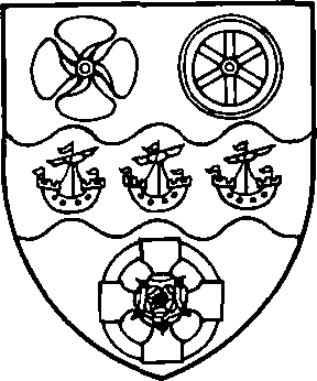
Argent on a fess wavy between in chief a ship's screw and a wheel azure and in base a Celtic cross also azure charged in the centre with a Tudor rose proper three lymphads argent.
[Granted 1957, regranted 1977]
[Granted 1957, regranted 1977]
In the 15th and 16th centuries the courts leet often fined offenders against the assize of bread and ale, those committing nuisances, and those causing affrays. In 1595 a man who had struck the lord of the manor, Thomas Kighley, with a sword, was fined 3s. 4d. In the later 16th century fines were also imposed on persons harbouring strangers. The manorial stocks were used to punish a man who had stolen materials from the sea wall (1567), a night prowler (1593), and a scold (1593). In 1573 the court sentenced a scold to a ducking, and ordered a stool for the purpose. Offenders expelled from the manor included a bigamist and her consort (1583). In 1577 it was reported that one of the constables had failed to raise the hue and cry after a felony; since he had been fined by the magistrates for his negligence the manor court remitted further punishment. Among administrative matters dealt with by the court between 1495 and 1600 were the regulation of pasture, woodland, and waste, the repair of roads and of copyhold houses, waifs and strays, and the salvage of wrecks. Between 1567 and 1600 the court was much concerned with the maintenance of the sea walls and ditches.
By 1715 the manor court was obsolescent, and during the following years its proceedings became increasingly formal, sometimes even antiquarian. Its main practical concern was the regulation of markets, fairs, and the manorial wharf. Its commercial monopoly had, however, been broken by the building of a rival wharf which the court had been unable to prevent or remove. James Theobald, who bought the manor in 1754, seems to have attempted to revive the court. He provided new stocks in 1757 and rebuilt the market house in 1774. A perambulation of the manor was carried out in 1792.
Surviving parish records include vestry minutes for the period 1724–1807, and poor rate books 1829–31, and 1833–5. The annual number of vestry meetings averaged 3.5 up to 1790, and afterwards 7.5. The meeting-place, when mentioned, was always the parish church, except occasionally when meetings were adjourned to a public house. In 1770 it was agreed that a fireplace should be provided in the vestry room. The numbers signing the minutes averaged 8.2 up to 1790 and afterwards 11.5. The largest number of signatures was 28 on 1 April 1771, when the repair of the church was under discussion. Dr. Robert Maxwell, vicar 1724–63, attended for the first time at Easter 1727. At that meeting the vestry approved a list of rules for parish business. One rule limited expenditure to 10s. at the Easter vestry and 5s. at 'private' vestries. Maxwell attended the Easter vestry regularly up to 1763, and often also 'private' meetings. His successor, James Adams, usually attended the Easter vestry from 1768, but hardly ever 'private' meetings. Adams's two successors, John Prince, 1785–93, and Thomas Percy, 1793–7 attended only one meeting each. Matthew Wilson, 1797–1822, often attended between 1798 and 1802, but not afterwards up to 1807. In the vicar's absence one of the churchwardens usually signed first. (fn. 258)
With the exceptions noted below there were always 2 churchwardens, 2 constables, 2 overseers of the poor, and 2 surveyors of highways. By 1725 or earlier one churchwarden was appointed by the vicar. The office of churchwarden was held by a very small circle of men, some of whom served for long periods. In nominating the constables, up to 1790, the vestry nearly always selected those chosen by the court leet, if that had met in the same year. (fn. 259) From 1791, however, the nominations of the two bodies never completely coincided. In 1791–1800 the leet was nominating 4 or 5 constables, not more than one of whom appeared in a contemporary vestry list. How many were actually confirmed by the magistrates is not clear. Some may have been special constables, like the 10 nominated by the vestry in 1803, who had agreed to serve in the event of a French invasion. In the earlier 18th century the overseers rarely served for more than two years at a time. Between 1740 and 1790 periods of 3 or 4 years were not uncommon. The list of surveyors of highways is incomplete, and no nominations are recorded after 1766.
Between 1763 and 1768, in the absence of the vicar, parish government was controlled, somewhat irregularly, by a group even more exclusive than usual. John Button, who had been joint warden with Robert Cornwell in 1760 and 1762–4, was sole warden in 1764–6, and joint warden with William Cornwell 1766–70. William Cornwell was sole overseer 1764–6. Edward Burrus was sole overseer 1766–8, and joint overseeer in 1768. John Button and William Cornwell were joint surveyors of highways 1763–6. From 1768 there were once again 2 wardens and 2 overseers, but Button and Burrus continued to dominate the vestry for many years. They were joint wardens 1770–93, and during that period each served several times as an overseer. Two salaried officers of the vestry are mentioned: the night watchman or bellman (1729) and the church clerk (1798).
Between 1725 and 1732 the annual cost of poor relief averaged £64. In the two years 1759–60 the average was £177. It fell to £154 in the period 1762–79, but rose again to £192 in the years 1780–99, and to £729 in 1800–17. (fn. 260) The poor rate produced £700 in 1830, £447 in 1833, and £335 in 1834. (fn. 261) The relative stability of the figures between 1760 and 1800 is remarkable when compared with those for some other south Essex parishes. (fn. 262) Even at Rainham, a neighbouring Thames port with no special problem of poverty, the average annual costs of relief rose much more sharply. (fn. 263) The figures for Grays Thurrock show virtually no increase in costs between 1762 and 1794. That was almost exactly the period during which John Button and Edward Burrus ruled the parish, and suggests that they enforced strict economy. The subsequent increases, from £158 in 1794 to £601 in 1800, were mainly the result of the French war, but may also reflect a milder regime. After 1800 costs were again kept fairly well under control, possibly by means of the new workhouse.
The first reference to a poorhouse was in 1774, when a building was leased for the purpose. Before that date the vestry minutes contain references only to out-relief, in the usual forms of weekly doles, rent allowances, cash grants for stock in trade, and medical care, with apprenticeships for children. A parish doctor was first employed on a regular contract in 1742. Another contract was signed in 1761, when smallpox was rife in the parish. In 1799 the vestry appointed a committee of six, under the chairmanship of the vicar, to set up a workhouse, and later agreed to take a 21-year lease of the existing poorhouse, which belonged to one of the committee. (fn. 264) In 1835 Grays Thurrock became part of Orsett poor law union.
A local board of 9 members was set up for the parish in 1886. John Howell was chairman 1886–8, and Edward R. Parker, of Belmont Castle, 1888–94. The board appointed a local solicitor, Charles Hatten, as part-time clerk and met at his offices in High Street. His firm, later Hatten & Asplin, held the clerkship of the board and U.D.C. until 1936. The board also appointed a full-time surveyor, a part-time medical officer, a rate-collector, and later a sanitary inspector. (fn. 265) The council carried out main drainage and also built a fire station for a voluntary brigade.
Under the Local Government Act, 1894, the local board was succeeded, in 1895, by an urban district council of 12 members. (fn. 266) Herbert E. Brooks, son-in-law of E. R. Parker, was chairman 1895–1914. Later chairmen held office for much shorter periods. The U.D.C. was at first dominated by business men, but a Labour member was returned as early as 1904, and in 1909 it was thought likely that there would soon be a Labour majority. (fn. 267) After some reverses, and the electoral truce during the First World War, Labour gained control at last in 1920, and held it until 1931. There was a Conservative majority from 1931 to 1935; in the year 1935–6 there were 6 Conservative and 6 Labour members.
The U.D.C. in its early years took over the cemetery and the fire brigade, opened an electricity undertaking, and joined with Tilbury and West Thurrock in a regional sewerage scheme. In providing parks and libraries they received substantial help from private benefactors. The council also built 25 workmen's houses, completed in 1902. Such houses were badly needed at Grays, but there as elsewhere municipal rents were too high for the poorer workers. In August 1909 more than half the council houses were unoccupied. The rents were then reduced by 1s. a week, and by November all were let. No more council houses were built before the First World War. A survey of 1919 showed that nearly half the houses in the town were occupied by two or more families. The council then began to build steadily, and by 1930 had completed some 600 houses. Under the leadership of Dr. W. G. T. Boul, medical officer from 1925, the public health department was greatly expanded. Dr. Boul eventually became medical officer also to the urban districts of Tilbury and Purfleet, and the rural district of Orsett. He was thus well placed to direct the health department of the enlarged Thurrock U.D.C., which he served as medical officer until 1961. (fn. 268)
Thurrock Urban District and Borough. Thurrock urban district, formed in 1936 from the urban districts of Grays, Tilbury, and Purfleet, and Orsett rural district, was divided into 13 wards, with 36 councillors, and from 1954 into 11 wards with 39 councillors. (fn. 269) In 1938 parts of Little Warley, Childerditch, West Horndon, and Dunton were transferred to Thurrock from Billericay urban district. (fn. 270) Thus enlarged Thurrock had an area of 40, 552 a., and a population of over 60,000. (fn. 271) In 1936 the Labour party had only 7 seats on a council consisting mainly of Independents, but they won seats at every election up to the war, and in 1946 gained control, which they held until 1978. In 1979 Labour had 18 seats, Conservatives 15, and Independents 6. (fn. 272)
By 1937 there were 4,500 council houses in the district. (fn. 273) After the Second World War the district embarked on a large-scale building programme, and by 1978 owned 15,000 dwellings. (fn. 274) Over 5,000 more dwellings were built in the district by the London county council. (fn. 275) By 1974, with a population of about 126,000, Thurrock was one of the largest urban districts in the country, both in population and area. (fn. 276) Among the public buildings erected by the U.D.C. were the swimming-pool and civic hall in Blackshots Lane (1964), (fn. 277) and the central library, museum, and theatre (1969–72). (fn. 278) In 1953, when parts of the district were devastated by floods, the council, in collaboration with the police, soon 'had the whole situation completely in hand'. (fn. 279)
Under the local government reorganization of 1974 Thurrock opted to become a borough, with 39 councillors, representing 11 wards. (fn. 280) A new shopping centre, with multi-storey car park above, was opened in Clarence Road, Grays, in 1975. (fn. 281) Since 1936 the main offices of the council have been in Whitehall Lane, Grays, in a converted house previously called Farley, and adjoining buildings. (fn. 282)
Publuic Services.
The Grays Thurrock Gas Co., later the Grays and Tilbury Gas Co., was incorporated in 1853. It confined its service to Grays and Tilbury until 1913, when it took over the undertakings at Laindon, Stanford-leHope, Billericay, and Rayleigh, and linked them to the Grays works, thus supplying the wide agricultural area from Rainham to Rayleigh. In 1930 the Grays and Tilbury Gas Co. was itself taken over by the Gas Light and Coke Co., which in 1931 closed the works in Southend Road, Grays. (fn. 283)
Grays Thurrock U.D.C. opened electricity works in Maidstone Road in 1901. (fn. 284) The under taking passed to Thurrock U.D.C., and in 1948 to the Eastern Electricity board. (fn. 285)
The South Essex Waterworks Co. was formed in 1861 to exploit the copious springs of pure water revealed by recent chalk quarrying at Grays. (fn. 286) Until 1891 the wells at Grays, with an elevated reservoir at Brentwood, supplied the whole of the company's area from Grays to Barking. (fn. 287)
In 1890, after pressure from the government, Grays local board agreed to carry out a main drainage scheme, to serve Little Thurrock and Tilbury as well its own district. The works, at Lodge farm, Grays, were completed in 1894. (fn. 288) In 1912 a joint sewerage board was formed for the urban districts of Grays and Tilbury and the parishes of West Thurrock, Stifford, and Little Thurrock. (fn. 289) The board's main work, completed in 1922, was a trunk sewer from Purfleet to Tilbury, with an outfall at West Tilbury. (fn. 290)
The Park, Orsett Road, was given by the squire, James Theobald, to the newly formed local board in 1887. (fn. 291) It was extended to the north in 1904. (fn. 292) The Beach recreation ground, Thames Road, was opened in 1906, partly as the gift of William Williams, another local landowner. (fn. 293) It comprised an artificial beach of fine sand laid on the river bank, with a raised walk and shelters. In 1979 the sand was grass-grown, but the small park and boating pool north of it were well tended. By 1971 Thurrock U.D.C. had 627 a. in 41 parks, including over 138 a. in 13 parks in Grays and Little Thurrock. (fn. 294) The Blackshots recreation area, Blackshots Lane, Little Thurrock, covers 60 a., and includes a civic hall and a swimming-pool, opened in 1964. (fn. 295)
A burial board of 9 members was formed for Grays in or shortly before 1878. (fn. 296) It bought land in Chadwell Road, Little Thurrock, part of which was consecrated as a cemetery in 1888. (fn. 297) The cemetery was taken over by the local board in 1894, and in 1919 Grays U.D.C. opened a new cemetery, adjoining the old one. (fn. 298) In 1957 Thurrock U.D.C. joined with Hornchurch U.D.C. and Romford B.C. to open the South Essex crematorium at Corbets Tey, Upminster. (fn. 299)
Grays volunteer fire brigade was formed in 1886. (fn. 300) The local board paid for most of its equipment and in 1893 built a fire station in Orsett Road. (fn. 301) Grays U.D.C. took over the brigade in 1903. A new fire station, in Hogg Lane, was built by Essex county council in 1954. (fn. 302)
Thurrock hospital, Long Lane, Little Thurrock, was built by Orsett R.D.C. in 1893 as an isolation hospital for the district. (fn. 303) In 1900 it was agreed that Grays U.D.C. should share the management. (fn. 304) In 1936, when the hospital was taken over by Thurrock U.D.C., it had 90 infectious beds and 18 sanatorium beds. (fn. 305) In 1978 it was mainly a geriatric hospital. (fn. 306)
Thurrock public libraries, up to 1956, have been described in a previous volume. (fn. 307) More recent events have included the building of 6 new branches, the reconstruction of the museum at Tilbury, and the opening in 1969–72 of a new central library, incorporating the Thameside theatre and local history museum, in Orsett Road Grays, on the site of the original free library. (fn. 308)
Parliamentary Representation.
In 1945 Thurrock, previously part of the South East Essex constituency, became a separate county constituency, conterminous with the urban district. It became a parliamentary borough in 1971. From 1945 up to and including 1979 it returned a Labour member. (fn. 309)
Churches.
The church of Grays Thurrock was given to the Knights Hospitallers in the later 12th century by William de Ferrers, earl of Derby. (fn. 310) The grant was confirmed c. 1190 by Richard FitzNeal, bishop of London, who at the same time licensed the appropriation of the church, and ordained a vicarage. (fn. 311) The date of the confirmation shows that the donor must have been the third earl (d. 1190) or his son of the same name (d. 1247). The rectory and the advowson of the vicarage remained with the Hospitallers until the Dissolution. (fn. 312) In 1544 they were granted by the Crown to William Riggs and Leonard Browne, who sold them in the same year to John Osborne. (fn. 313) Osborne sold them in 1569 to Thomas Farnell and Thomas Russell. (fn. 314) Farnell's half remained in his family until 1586, when Simon Farnell sold it to John Hill. (fn. 315) Hill, who presented to the vicarage in 1588, sold half of the rectory and advowson in 1590 to Thomas Newman. (fn. 316) John Russell, heir of Thomas, was holding the other half at least until 1586. (fn. 317) Thomas Newman evidently acquired that also, for in 1601, shortly before his death, he settled the whole rectory on his son Matthew. (fn. 318)
Matthew Newman sold the rectory and advowson in 1618 to Robert Johnson, who sold them in 1623 to John Babington the elder and John Babington the younger. (fn. 319) In 1650 the owner was John Babington, clerk, who had leased the rectory to John Ludlow and John Lambert. (fn. 320) John Babington, gentleman, sold the rectory and advowson in 1671 to George Townsend, who presented in 1682. (fn. 321) By his will dated 1682 Townsend endowed scholarships at Pembroke College, Oxford, and directed that scholars from his foundation should be presented to the vicarage of Grays Thurrock on the nomination of his sonin-law William Kenwrick, and after Kenwrick's death by Townsend's grandson James Silverlock. (fn. 322) James Silverlock was the patron and impropriator of Grays in 1685. (fn. 323) In 1692 he sold the rectory and advowson to William Kenwrick. (fn. 324) That William Kenwrick, who may have been the son of the previous William, died in 1706, leaving the rectory and advowson to his niece Anne, wife of Richard Anderson, pretending baronet, of Stifford. In 1707 Richard and Anne Anderson sold them to Sir Thomas Davall (d. 1712). (fn. 325) The rectory and advowson thus passed out of the hands of George Townsend's descendants, and no scholar of Pembroke College was ever presented to the living.
Sir Thomas Davall, son of the previous Sir Thomas, died in 1714, leaving a widow, Lydia Catherine, and an infant son Thomas. After the death of the young Thomas in 1718 there was a Chancery suit (1719–22), which left Lydia Catherine with most of her husband's estates, including the rectory and advowson of Grays Thurrock. She married James Brydges (d. 1744), duke of Chandos, in 1736, and died in 1750. She was succeeded by her nephew Sir John van Hattem, who sold the rectory and advowson in 1777 to Zachariah Button. (fn. 326)
From the early 19th century the rectory and the advowson descended separately. John Button presented up to 1819. (fn. 327) The advowson later passed to the Revd. H. S. Hele, who successively presented his two sons, in 1828 and 1837. (fn. 328) James Theobald, lord of the manor, presented his son Charles in 1856 and William H. Richards in 1862. (fn. 329) In 1871 Richards sold the advowson to Jeremiah Long, whose family held it until c. 1922, when it was conveyed to the bishop of Chelmsford. (fn. 330)
The rectory belonged in 1843 to Richard Lake and John Curtis, both of London. (fn. 331) They owned all the great tithes except those of three farms, comprising about a quarter of the parish, where the great tithes had been merged in the freehold. By 1848 the great tithes had passed to the Errington family, which retained them until 1937 or later. (fn. 332)
The rectory was valued at 30 marks in 1254, £10 in 1338, £7 6s. 8d. in 1535, and £46 in 1650. The vicarage was valued at 2 (formerly 5) marks in 1254, £5 os. 8d. in 1535, and £27 in 1650. (fn. 333) In 1843 the impropriate great tithes were commuted for £220. There was then no rectorial glebe. The small tithes were commuted at the same time for £250; the vicar's glebe comprised only ½ a. around his house. (fn. 334)
The Vicarage house was described in 1650 as a small cottage. (fn. 335) In 1685 the vicar intended to pull it down and build a new one. (fn. 336) In 1810 the Vicarage, which adjoined the church, was of brick, weatherboarding, lath and plaster, partly tiled and partly thatched. (fn. 337) It was rebuilt in 1826 by the patron, H. S. Hele. (fn. 338) In 1921 II ford House, High View Avenue, was bought as the Vicarage. (fn. 339) The old Vicarage was sold to Horncastle's to extend their furniture store; it was demolished in 1973. (fn. 340)
The poverty of the living and the remoteness of this marshland parish were evidently unattractive to the clergy. Before the 19th century few vicars are known to have stayed as long as 10 years, and most vacancies occurred by resignation. (fn. 341) John Williams, instituted in 1578, was in the same year charged with seditious preaching and may have been removed. (fn. 342) Daniel Jones, vicar in 1650, was said to be 'negligent and of bad life and conversation'. (fn. 343) He had at least three successors before 1662, and there were six more vicars before 1700. (fn. 344) Robert Maxwell, D.D., vicar 1724–63, lived in the parish, but his successors up to 1826 seem usually to have been absentees, and they employed assistant curates. (fn. 345) George Hele, vicar 1828–37, resigned the living because of his 'bilious constitution and the insalubrity of the climate'. (fn. 346) His brother Henry, 1837–56, rebuilt the church. An outstanding vicar in the present century was Arthur H. W. Seally, 1905–33. (fn. 347)
The church of ST. PETER AND ST. PAUL, High Street, is of ragstone and flint rubble with limestone dressings, and has chancel with crossing, north Lady Chapel with tower above, south organ chamber (formerly chapel), nave, north aisle, north and south porches, north and south vestries. (fn. 348) It was largely rebuilt in the 19th century.
The chancel, nave, and crossing were probably built in the 12th century, and a doorway of that period, formerly in the north wall of the nave, is now in the north porch. A central tower may originally have been planned, but about 1230 a tower was built north of the crossing, and the south chapel was added opposite c. 1280–90. From the 17th to the 19th century the chapel was regarded as the property of the lord of the manor. There seem to have been no major alterations to the church between the 13th and the 18th centuries. In 1685 the archdeacon ordered emergency repairs to the tower. (fn. 349) About 1722 the spire, being old and decayed, was taken down. (fn. 350) The church was 'beautified' and the west end repaired in 1725. (fn. 351) The upper part of the tower was blown down in 1770, and was crudely restored in timber, lath and plaster. (fn. 352) The tower needed urgent repairs again in 1796, and by 1846 was rotten and unsafe. (fn. 353)
A major restoration in 1846 obliterated most of the ancient features of the church. The top stage of the tower was rebuilt and crowned with a broach spire. The nave was largely rebuilt, and probably also the south porch. (fn. 354) In 1867 the nave was extended westwards, and a north aisle and south vestry were added, to the designs of Henry Stock. (fn. 355) Between the two world wars the north (choir) vestry was added, the south (clergy) vestry was extended, the organ was moved to the south chapel, and the ground-stage of the tower became the Lady Chapel. (fn. 356) The north porch was built as a war memorial in 1958, incorporating the 12th-century north doorway, which had been removed in 1867, but had been preserved in the garden of Duvals, Meesons Lane.
The church has three bells, all of 1883. (fn. 357) They replaced a pair dating from c. 1510 and 1685. The plate includes a cup of 1663 and patens of 1628 and 1685, all of silver. (fn. 358) The 1685 paten was given by William Palmer, and in 1956 Palmer's schools gave a matching cup of modern silver. (fn. 359)
The octagonal font dates from c. 1500. (fn. 360) The early 16th-century screen, which in 1871 enclosed the chancel, had by 1923 been moved to its present position between the crossing and Lady Chapel. (fn. 361) The stained glass in the windows of the nave and aisle, designed by Philippa Heskett, was given by various donors between 1973 and 1977. A charity board, dated 1725, hangs in the nave. In the chancel are two carved armchairs, possibly of the later 17th century, and a helm, with gauntlet and sword, attributed to the late 16th century. On the south vestry floors are some glazed medieval tiles, found on the site of a cottage north of the church.
The monuments in the chancel include one to Anne Cox (d. 1796), by Charles Regnart, (fn. 362) and the remains of a brass of c. 1520, originally depicting a civilian, his two wives, son, and six daughters, but now showing only the wives and daughters. (fn. 363) In the nave is a monument by Druitt of Mile End (Lond.), to the schoolmaster and boys who died in the burning of the training ship Goliath. There are tablets in the aisle to various members of the Seabrooke family, 1791–1916. Fixed to the west wall of the nave and aisle are tablets commemorating those whose gravestones were disturbed when the church was enlarged in 1867.
It was stated in 1650 that two houses called the King's Head and the Anchor and Hope rightly belonged to the church, but had been detained from it. (fn. 364) There is no evidence that the church recovered those properties.
The church of ALL SAINTS, Grays Thurrock, John Street, originated in 1886, when the Grove mission district was formed. An iron church was built in William Street in 1887 at the expense of James Theobald. The mission later included a hall in the Broadway, and for some years also an institute in William Street. Frederick Hasluck was curate-in-charge until his death in 1906. All Saints was then placed under the vicar of Grays, who had charge of it until 1921, when it again became a mission district. A separate parish, taken from Grays Thurrock and Little Thurrock, was formed in 1926, the advowson being vested in the bishop. A permanent church, designed by Sir Charles Nicholson, was opened in 1927. (fn. 365)
The iron church of ST. MARY, South Stifford, Moore Avenue, originated in 1920 as a mission in Stifford parish, under a lay reader. (fn. 366) It was placed under Grays Thurrock for administrative purposes c. 1954, and in 1959 was formally transferred, with its mission district, to that parish. (fn. 367)
Roman Catholicism.
A temporary chapel in Argent Street was in use by 1878. (fn. 368) The permanent church of ST. THOMAS OF CANTERBURY, East Thurrock Road, was opened in 1886. (fn. 369) The convent of La Sainte Union des Sacrés Coeurs, College Avenue, was founded in 1899, when the sisters of this teaching order took premises in Orsett Road. The original buildings in College Avenue were opened in 1906. (fn. 370)
Protestant Nonconformity.
In 1701 John Hurman registered the house of Robert Dalzell for Independent worship. (fn. 371) No more is known of that congregation, and in 1766 there were said to be no dissenters in the parish. (fn. 372) At the beginning of the 19th century Grays attracted missionaries from all the main dissenting bodies. In 1810 there was a small Wesleyan society which had licensed a house about 10 years earlier and was served by preachers from London. (fn. 373) It may have been the meeting, described as Independent, which J. S. Smith registered in 1797. (fn. 374) Itinerant preachers of the Essex Baptist association were visiting Grays in 1815. (fn. 375) A house was registered for Baptists in 1831 by James Wigg, a labourer. (fn. 376) All these efforts seem to have been abortive, and it was left to the Congregationalists to found the first permanent church in the town.
Christ Church United Reformed church, Bradleigh Avenue, originated in mission work launched in 1799 by the Essex Congregational union. (fn. 377) The union's agent J. F. Cover, based at Horndon-on-the-Hill, was preaching at Grays up to 1803. When he left the district in that year the union arranged for a visiting preacher to come from Purfleet. Progress was slow. There was no regular meeting-place, and several Grays Congregationalists became members of the South Ockendon church. (fn. 378) One of them, John Blaker, hired the old market house in West Street, Grays, and registered it for worship in 1824. (fn. 379) By 1829 the attendance was about 150, under George Johnson of Horndon-on-the-Hill, another agent of the E.C.U. (fn. 380) In 1836 Grays Congregational church was formally established, with Johnson as pastor. The market house was still being used in 1851, (fn. 381) but it was pulled down about 1852 to make room for redevelopment. (fn. 382) The congregation struggled on in makeshift meeting-places until 1858, when A. Griffin became pastor. In the same year a site was given in Bridge Road, on which a small flint and brick church was built, modelled on Griffin's previous church at Watton (Norf.).
During the ministry of James Merchant, 1860–91, membership grew. In 1885 the church site was sold to the adjoining Seabrooke's brewery, and a new building, opened in 1886, was erected at the corner of New and Bridge Roads. In 1941 the church was gutted by incendiary bombs. The members moved to St. John's mission, College Road, Little Thurrock, where they remained until 1950, when a temporary hall was built on a new site in Bradleigh Avenue. (fn. 383) A permanent church, designed by Alan Cook in honey-coloured brick and stone, was opened in 1956. The interior has exposed ornamental brickwork, stone, and light oak panelling, furniture, and fittings. Above the altar is a stained-glass rose window of c. 1926, designed by a former minister, A. E. Fox, and preserved from the old church. In 1972 Christ Church joined the United Reformed Church. There were 104 members in 1979. (fn. 384)
There were three Methodist churches at Grays at the union of 1932: New Road (United), New Road (Primitive), and London Road (Wesleyan). In 1935, after the closure of New Road (U), the two surviving churches became part of the new Grays circuit. (fn. 385)
New Road Methodist (U) church seems to have originated in a Wesleyan society which in the early 1840s was meeting in a cottage in High Street. (fn. 386) A small church was built in 1847 at the corner of Prospect Place and Bridge Road. (fn. 387) By 1851, under the leadership of William Harvey, it had joined the Wesleyan Reform connexion, being included in the Third and Eighth London circuit. (fn. 388) It was later in the Fifth London (Stratford) circuit of the United Methodist Free Church, which became the London (Forest Gate) circuit of the United Methodist Church. (fn. 389) In 1873 a larger church was built in New Road, and a hall seating 500 was added in 1887. Both buildings were the work of a local builder, H. J. Carter, who was also a church member. The debt incurred in erecting them was not cleared until 1904, when a grant was obtained from Andrew Carnegie. There were 102 members in 1928, (fn. 390) but the church became redundant in 1932 and was sold in 1934.
New Road Methodist (P) church originated c. 1850, in cottage meetings led by Thomas Hills in London Road and James Snell in Argent Street. (fn. 391) In 1851 Hills, Snell, and their wives formed a society of four members, attached to the mission at Aveley. Meeting rooms were registered in Bond Street in 1857, (fn. 392) and a church was built in New Road in 1870. Missionaries from Grays founded a church at Romford, (fn. 393) and in 1877 the Grays and Romford circuit was formed, with New Road at its head. (fn. 394) The church was damaged by bombs in 1940, (fn. 395) and with falling membership was closed in 1948.
London Road Methodist (W) church originated in the late 1870s, when a small society in the Gravesend circuit began meeting in Quarry Hill board school. (fn. 396) The church, opened in London Road in 1885, was then the largest free church in Grays, costing over £3,000. (fn. 397) In 1895 the Grays circuit was formed. (fn. 398) The church was damaged by bombing in 1940. (fn. 399) It is a massive brown brick building with a pedimented portico.
Lodge Lane Methodist church was opened in 1939 to serve a new housing area, in the Grays circuit. It stands in a hollow, screened by trees. The cost of the building was met partly by the sale of the former New Road (U) church. (fn. 400)
Ebenezer Strict Baptist church, Grove Road, originated c. 1854 with open-air meetings held by John Whitmore, followed by cottage meetings. (fn. 401) A church was formed in 1878, and Ebenezer was built in 1879. (fn. 402)
Grays Baptist Tabernacle, Orsett Road, originated in 1884 when the Essex Baptist association started meetings in Chapel Villa, London Road. (fn. 403) An open communion church was formed in 1885, and an iron church was built in the same year in Dell Road. In 1894 the Tabernacle was built in Orsett Road. It supported missions at Tilbury, opened in 1894, and Purfleet. In 1936 there were 236 members. During the Second World War the church was wrecked by bombing, losing most of its records. From 1944 services were held in the Sunday school. (fn. 404) The Tabernacle was reopened in 1948. In 1979 there were 119 members.
Socketts Heath Baptist church, Premier Avenue, Little Thurrock, originated in 1890, with meetings at a house in New Road. (fn. 405) In 1891 a church was formed in connexion with the Old Baptist Union, and supported by the union's church at Battersea (Lond.). Meetings were held at Quarry Hill school and later at the Masonic Hall. J. J. Winser was pastor 1895–1936. (fn. 406) A church was built in Clarence Road in 1898. A mission was opened in 1900 in College Road, Little Thurrock, and another at Stifford. In 1903 Clarence Road and other churches left the Old Baptist Union and formed a Christian Union under Winser's chairmanship. When that was dissolved in 1913 Clarence Road joined the Baptist Union. In 1933 a new church was built at Socketts Heath, where mission work, sponsored by the Essex Baptist association, had been in progress for some years. The Clarence Road building was sold to the Salvation Army. In 1979 Socketts Heath had 69 members. (fn. 407)
The Evangelical (formerly Peculiar People's) church, Salisbury Road, may have originated as early as 1871, when there were said to be Peculiar People at Grays. (fn. 408) By 1886 regular meetings were being held in Quarry Hill school. (fn. 409) The church was built in 1892. (fn. 410) It was designated as Evangelical in 1956. (fn. 411) Grange Road Peculiar People's chapel was built in 1901, (fn. 412) probably by seceders from Salisbury Road. The new chapel's elder was H. H. Carter, formerly leader of the Salisbury Road Sunday school. (fn. 413) In 1906 a child died of diphtheria after its father, supported by Carter, had refused medical aid; both the father and Carter were imprisoned for manslaughter. Carter remained elder until his death in 1921. (fn. 414) The chapel seems to have closed before 1933. (fn. 415)
The Salvation Army citadel, Clarence Road, seems to have originated in 1883, when a mission was held in a converted travelling theatre. (fn. 416) An 'outpost station' at Quarry Hill school was registered in 1884. (fn. 417) Later that year it was reported that roughs were attacking the Salvationists' open-air meetings. (fn. 418) In 1896 the corps moved first to Bridge Road and then to a large iron hall in High Street. (fn. 419) They moved again in 1904, to an iron hall in Globe Terrace, at the bottom of Old High Street. (fn. 420) In 1934 they bought the old Baptist church in Clarence Road. (fn. 421) The citadel was restored and refronted in 1973. (fn. 422)
The Friends' meeting, London Road, Grays, originated in private meetings which were already well established in 1896. In 1906, with help from the Friends' home mission and extension committee, a shop was converted into a mission room and opened for public worship, within the Ratcliff and Barking monthly meeting. During the 1920s the membership reached a peak of about 70, but by 1953 it had declined to 2, and the meeting was then closed. (fn. 423)
A Plymouth Brethrens chapel, location not stated, was listed from 1885 to 1890. (fn. 424) In 1898 Brethren were meeting at a coffee-house in High Street. (fn. 425) Before 1914 Exclusive Brethren built a small hall in York Road. It still survived in 1957, but had been demolished by 1973. (fn. 426) Open Brethren registered an iron hall in Victoria Avenue in 1938. (fn. 427) It closed in 1970. (fn. 428) The Pentecostal church of the Assemblies of God, Bridge Road, originated c. 1926 as a mission in Clarence Road. (fn. 429) The present church, called Clarence hall, was opened in 1937. (fn. 430) The Lodge Full Gospel Assembly Pentecostal church, Chestnut Avenue, was built c. 1935. (fn. 431)
Sikhs.
In 1978 there was a Sikh Temple in a converted building in Maidstone Road. (fn. 432)
Education.
A charity school, which survives as Palmer's college, was founded in 1706. From 1876 it was providing secondary education for boys and girls. A Church school, opened c. 1857, was maintained with difficulty because many inhabitants were nonconformists. (fn. 433) A school board, at first dominated by nonconformists, was formed for Grays in 1882. (fn. 434) It built two elementary schools, in 1884 and 1888, and an upper-standard school in 1898. Two of these schools were later rebuilt by the county council, which also built a central, later technical, school, an infant school, 3 special schools, and a technical college. Roman Catholics opened an elementary school in 1885 and a secondary girls school in 1906. In 1971 the secondary schools were reorganized as comprehensive, with a sixth-form college.
Palmer's college, Chadwell Road, Little Thurrock. (fn. 435) Palmer's charity school founded 1706, has been briefly described elsewhere. (fn. 436) There were 4 successive masters between 1709 and 1781, when John Horncastle was appointed. In 1844 the school was managed solely by William Horncastle, master 1815–48, who did not teach Latin according to the trust. A new school was built in 1849 next to the master's house. In 1856 it was enlarged and a Chancery order permitted admission of paying pupils. In 1874 a new school was opened in Palmer's Avenue for 100 day boys and 40 boarders. A school for 50 day girls and 25 boarders was opened on the same site in 1876. The schools were enlarged in 1894, 1895, 1898, 1906, and 1913. They were united under one headmaster in the period 1906–18. In 1931 a new school in Chadwell Road, with a boarding hostel, was completed for 400 girls. By 1937 buildings in Palmer's Avenue had been reconstructed for the boys. In 1939 the boarding hostels were closed; the boys hostel reopened in 1947 when Palmer's schools were granted Voluntary Controlled status. (fn. 437) An open-air theatre was built at the girls school in 1954, partly with funds from the William Palmer education trust; in 1964 the school was enlarged. (fn. 438) In 1971 both schools were reorganized as a Voluntary Controlled mixed sixth-form college. (fn. 439) The boys boarding hostel closed in 1973. (fn. 440) In 1977 the college moved to the altered and enlarged buildings of the former girls school in Chadwell Road. (fn. 441)
Grays National school, New Road. (fn. 442) In the early 19th century Churchmen made intermittent attempts to establish a school. A National day and Sunday school, listed in 1817, seems to have survived in 1819 only as a Sunday school. (fn. 443) A new Sunday school, opened in 1824, had 162 children in 1833 and still existed in 1846, when there was also a day and Sunday school for infants. (fn. 444) About 1857 a National girls and infant school, under a trained teacher, was opened in a rented house by the vicar, Charles Theobald. That school, in High Street, seems to have survived in 1866, (fn. 445) but had closed by 1870, because its building had become 'too weak for such hard wear'. (fn. 446) A new National school, for boys, girls, and infants, was opened by 1871, when it was receiving a government grant. (fn. 447) Permanent buildings, with places for 420, were built in 1873 by subscription and grants, on land in New Road given by James Theobald. (fn. 448) In 1883 the National school rejected the proposal that it should be taken over by the newly formed school board, but in 1884 it was forced to close for want of funds. It was reopened in the same year under a new trust deed which disqualified members of the board from chairmanship of the National school management committee. (fn. 449) James Theobald continued to support the school until his death in 1894. (fn. 450) After further financial difficulties it finally closed in 1910.
Quarry Hill county junior and infant schools, Bradleigh Avenue and Dell Road, were opened in 1884 as a board school for 640 on Quarry Hill. (fn. 451) The school received annual government grants from its opening. (fn. 452) It was enlarged in 1885 for 973 children. In 1898 it became a junior school. Seniors were again admitted from 1910. (fn. 453) Evening classes for adults were held there in the period 1898–1908. (fn. 454) In 1936 the school was reorganized for juniors and infants. The junior school moved in 1969 to new buildings in Bradleigh Avenue. The infants moved in 1973 to new buildings in Dell Road. (fn. 455) The old school was demolished in 1977.
St. Thomas of Canterbury Roman Catholic junior and infant school, Ward Avenue. (fn. 456) A Catholic school existed in 1863 (fn. 457) but the first permanent school was opened in 1885 at Argent Street chapel, originally for the children of Irish labourers building Tilbury docks. In 1886 it moved to rooms under the new church in East Thurrock Road. It received annual government grants from 1887. (fn. 458) Attendance increased from 60 in 1885 to 101 in 1888. In 1939 the school had 300 children. In 1947 the seniors were transferred to St. Mary's school, Tilbury. The school was granted Aided status in 1951. (fn. 459) New buildings in Ward Avenue for 240 juniors and 120 infants were opened in phases between 1963 and 1969, when the old school was closed.
Thameside junior school, Manor Road and Arthur Street, originated as Arthur Street board school, opened in 1888 for 680. (fn. 460) It was enlarged in 1892 for 1,040 and by 1911 was attended by 995. (fn. 461) In 1898 it became a junior school. (fn. 462) Seniors were again admitted from 1910. (fn. 463) Arthur Street was reorganized in 1936 for juniors and infants. It was renamed in 1957. The juniors moved to new buildings in Manor Road in 1973. (fn. 464) In 1977 the infants remained in their original building. (fn. 465)
Bridge Road board school was opened in 1898 as an upper-standard school for 600 seniors from existing schools. (fn. 466) It was enlarged in 1906 for 840. (fn. 467) In 1910 it was reorganized as an elementary school, taking infants and juniors from the National school and the council schools at Quarry Hill and Arthur Street. (fn. 468) In 1912 an infants school was added. (fn. 469) In 1925 the boys were transferred to other schools, (fn. 470) and the infants building was taken over by the John Henry Burrows central school. The girls and infants remained in the former boys and girls buildings until 1936 when the school was closed and the buildings were taken over by Park senior council school. (fn. 471)
Grays convent high school, College Avenue. In 1906 the sisters of La Sainte Union des Sacrés Coeurs moved to College Avenue and opened a school in the convent there. (fn. 472) In 1934 new buildings for 220 girls were opened next to the convent. (fn. 473) The school was bombed in the Second World War, and in the 1950s the damaged part was rebuilt and the school enlarged. In 1969 it was granted Aided status and reorganized as a secondary comprehensive school. It was enlarged 1972, (fn. 474) and in 1977 was attended by 666.
Grays school, Hathaway Road, originated in 1925 when the county council opened the John Henry Burrows central school for 300 in the former Bridge Road infants school. (fn. 475) In 1931 it moved to new buildings for 360 in Hathaway Road. (fn. 476) It became a secondary technical school in 1945. (fn. 477) In 1968 it was amalgamated with Aveley technical school as Aveley and Grays technical high school. In 1971, when the school was reorganized, part of it became Grays comprehensive school and moved to the remodelled and enlarged buildings in Hathaway Road. (fn. 478)
Park senior council school, Bridge Road, opened in 1936 for 960 in the buildings of the former elementary school. It became a secondary modern school in 1945. The boys and girls departments were amalgamated in 1958. The school was closed in 1971. (fn. 479)
Thurrock technical college, Woodview, was opened in 1952 as a technical institute in Dell Road. Buildings at Grays Hall and Hathaway Road school were used in the period 1954–7. New buildings at Woodview, completed in three phases, were officially opened in 1960. (fn. 480) In 1977 the former Aveley school in Back Lane and Love Lane was taken over by the college's department of management and business studies.
Bridge Road special school was built in 1913 for 72 mentally deficient children from Grays, Aveley, Stifford, and West Thurrock. It was closed in 1936. (fn. 481) Quarry Hill partially blind council school was opened in 1928 and closed in 1940. (fn. 482) Treetops school, Dell Road, was opened in 1930 as Grays Thurrock open-air school for 60 delicate children. It was renamed in 1964 and rebuilt for 160 in 1968. (fn. 483)
In 1808 there were three private day schools with about 34 girls; there was also a boarding school for about 40 girls which still survived in 1827. (fn. 484) Mary Ann Woolnough (later Horncastle) kept a preparatory school from c. 1848 until c. 1866. (fn. 485) In 1906 three of the four private schools in Grays were preparatory schools; the fourth, Thornton girls school, seems to have been established by 1886 and closed by 1937. (fn. 486)
Charities for the Poor. (fn. 487)
The Unknown's charity. By 1593 the origin of a gift to the poor of the profits from a flock of 40 sheep was forgotten. The income was then given to the poor in bread, cheese, and beer in Rogation week. In 1599 the parishioners complained that the sheep had been taken and no profits paid to the churchwarden. A charity commission's decree of 1605 ordered replacement of the sheep, the taking of a bond from those who had them, and payment of the profits as formerly. The profits were distributed accordingly but no bonds were taken. Part of the gift was lost c. 1623 when a churchwarden claimed 10 sheep in settlement of the parish's debt of £4; the rest of the income was paid out in money. In 1626 the profits were not distributed, and the parishioners again complained. (fn. 488) By the early 18th century the gift had been commuted for £20, probably by Joseph Brandon (fl. 1680), to whom the charity was ascribed in 1786. (fn. 489) By 1785 the capital was £14 producing 14s. yearly, which from that time was given out in bread regularly by the churchwardens. (fn. 490) A Scheme of 1938 regulates use of the 11s. income from £22 stock for the general benefit of residents of the ancient parish.
Palmer's charity for bread and coals. William Palmer, whose foundation of Grays school is described above, charged his trustees, by deed of 1706, yearly to clothe 4 poor children for not more than £8, to buy 5 chaldrons of coal for the poor, and to pay the parish officers £1 for monthly and annual bread doles. By 1837 the trustees were spending £9 yearly on clothing, and the churchwardens gave out bread and 4 chaldrons of coal, leaving one for the school. Surviving accounts of the 1860s suggest that less was given in bread and more in coal at that time. (fn. 491) A Charity Commission order of 1906 established a charity separate from the original one with £400 stock to provide £10 yearly for bread and coals. A Scheme of 1938 regulates its use for the general benefit of the ancient parish.
William Hansworth (d. 1759) (fn. 492) by his will gave a rent charge to the poor from four houses in Grays. Its receipt, often in arrears, and its distribution are recorded between 1778 and 1806. (fn. 493) From 1834 the owner of the houses refused payment, claiming that the legacy was void by the Statute of Mortmain.
The Webb charity was founded in 1961 by Mrs. A. J. Smith (née Webb) who gave £100 stock to provide Christmas gifts to widows and the aged living in Grays. (fn. 494)
The Umfreville Memorial charity was founded in 1969 by D. E. Umfreville. The income from a small investment with contributions from the Umfreville family is given to charitable organizations at the trustees' discretion. (fn. 495)