A History of the County of Essex: Volume 9, the Borough of Colchester. Originally published by Victoria County History, London, 1994.
This free content was digitised by double rekeying. All rights reserved.
A P Baggs, Beryl Board, Philip Crummy, Claude Dove, Shirley Durgan, N R Goose, R B Pugh, Pamela Studd, C C Thornton, 'Tudor and Stuart Colchester: Topography', in A History of the County of Essex: Volume 9, the Borough of Colchester, ed. Janet Cooper, C R Elrington (London, 1994), British History Online https://www.british-history.ac.uk/vch/essex/vol9/pp102-110 [accessed 30 April 2025].
A P Baggs, Beryl Board, Philip Crummy, Claude Dove, Shirley Durgan, N R Goose, R B Pugh, Pamela Studd, C C Thornton, 'Tudor and Stuart Colchester: Topography', in A History of the County of Essex: Volume 9, the Borough of Colchester. Edited by Janet Cooper, C R Elrington (London, 1994), British History Online, accessed April 30, 2025, https://www.british-history.ac.uk/vch/essex/vol9/pp102-110.
A P Baggs, Beryl Board, Philip Crummy, Claude Dove, Shirley Durgan, N R Goose, R B Pugh, Pamela Studd, C C Thornton. "Tudor and Stuart Colchester: Topography". A History of the County of Essex: Volume 9, the Borough of Colchester. Ed. Janet Cooper, C R Elrington (London, 1994), British History Online. Web. 30 April 2025. https://www.british-history.ac.uk/vch/essex/vol9/pp102-110.
In this section
TOPOGRAPHY
The Town to 1640
By c. 1500 houses extended well beyond the town walls in ribbon developments along the major roads, notably East Hill and East Street, Middleborough and North Street, and Magdalen Street, and in more compact suburbs outside South gate and Head gate. The settlement at the Hythe was still separated from the town by fields. Within the walls large areas of open ground remained, notably at Bury field in the south-east quarter, around the castle in the north-east, and between the wall and Head Street and North Hill in the west. Even in the main streets a decline in population in the later Middle Ages had reduced the pressure on space, and most houses had gardens or yards. Physical decay, particularly in the northern and southeastern suburbs, seems to have become noticeable by the 1520s and 1530s, and the dissolution of the monasteries hastened the decline of the south-eastern suburb, which had been dominated by St. John's abbey and St. Botolph's priory.
By 1535 four cottages in Magdalen Street had fallen down, and an empty house site in the same street was recorded in 1538. (fn. 1) By 1539, of the houses owing rents to St. John's abbey, two in Stanwell Street and two in Lodder's Lane (Abbeygate Street) were 'decayed', and another, possibly in East Stockwell Street, had been knocked down, but the total of five houses was relatively insignificant in a rental of c. 163. (fn. 2) A house and three 'rents', small houses or cottages, at the Hythe were made into one house before 1542. (fn. 3) Before 1543 a total of 29 houses in Head ward, at least nine of them within the walls, had either been taken down or were 'sore decayed', (fn. 4) but not all were necessarily dwellings. As many as 13 houses formerly belonging to St. John's south and east of the walls had fallen down or been destroyed by c. 1550: 2 in Magdalen Street, 1 in Stanwell Street, 4 in Lodders Lane, at least 3 on St. John's green, 2 in East Street, and 1 in Holy Trinity parish, probably outside Scheregate. Another 34 were in need of repair. Not all the 'decay' was recent; three houses in Lodders Lane had been 'badly devastated' for 16 years, and that in Holy Trinity parish had been totally destroyed 'for a long time'. The decay of a house in East Street and of the Lamb or New inn on St. John's green was attributed to the attainder of the abbey in 1539. (fn. 5)
Two houses beyond North bridge had been made into one by 1534, and two in Wyre Street were similarly joined in 1540. Buildings on a plot in Stockwell Street, apparently developed late in the Middle Ages, had fallen down by 1541. (fn. 6) A house called Hell, on the south side of Culver Street, seems to have been demolished between 1540 and 1543. (fn. 7) In 1548-9 the borough chamberlain was unable to collect rents from unoccupied houses outside Ryegate, in Bere Lane (Vineyard Street), and next to Holy Trinity church, while a house in East Street had fallen down. (fn. 8) There were still at least 2 empty plots, formerly house sites, in Stanwell Street, 1 in Lodders Lane, and 3 on St. John's green in 1581. (fn. 9)
Elsewhere there is evidence for increased occupancy and some new building or rebuilding. A house in St. Botolph's parish, divided in 1503, remained so in 1549, and ownership of part of a house there was disputed c. 1530. (fn. 10) Part of a large house in St. Peter's parish was sold in 1543, and Thomas Whitbread (d. c. 1520) divided a house in Headgate into two. A large house in West Stockwell Street seems to have been divided in 1532. (fn. 11) In 1542 the former St. Botolph's priory barn near the corner of St. Botolph's Street and Magdalen Street was converted into houses, and other parts of the St. Botolph's site developed. (fn. 12) In 1548-9 the chamberlain collected rents from 'newly built' shops and solars in front of the Red Lion inn and from 'new' buildings in Maidenburgh Street behind the George inn. (fn. 13)
When the economy began to recover in the 1550s or 1560s, (fn. 14) physical repair and expansion soon followed. In 1578 the borough required the tenant of a house west of the moot hall to rebuild the parts of it which had fallen down. (fn. 15) In 1580 alderman Robert Mott sold a house 'lately waste and recently built' in St. Martin's parish. At least one plot of land taken from Bury field had been 'lately' built on in 1581. A newly built house on the corner of North Street and Sheepen Lane was sold in 1594. (fn. 16) In 1610 the borough granted a building lease of a piece of waste in St. James's parish, and licensed building on the waste in East Stockwell Street. (fn. 17) Another building lease, of land at the Hythe, was granted in 1608, and in 1609 Henry Barrington agreed to build a new millhouse there with a cellar, a brick chimney, and two fireplaces. In 1623 the water bailiff was instructed to demolish and rebuild the warehouses on the waterfront. (fn. 18) Two new houses were built next to a house in All Saints' parish between 1559 and 1621. By 1634 the adjoining barn had been made into a cottage, and that too was divided in 1635. (fn. 19) The former no. 11 Sir Isaac's Walk may also have been converted to a dwelling-house from a barn at that time. It stands well back from the street frontage, and its plan, with three rooms on each floor and a large internal stack, is like that of a farmhouse. Before 1625 two 'rents' and a house were built in Dovehouse field on the west side of the road beyond North bridge, and the borough granted a building lease of a large plot outside Headgate in 1619. (fn. 20)
Division of houses continued: a house called the Crown, on the south side of High Street next to the Red Lion inn, had been divided into two before 1555, and in 1597 it was occupied by four households. (fn. 21) William Ingram in 1601 and 1603 sold two separate parcels of his house in Wyre Street, which itself seems once to have been part of the neighbouring house. By 1622 a house in All Saints' parish was divided between three or four tenants, some apparently occupying only one room. (fn. 22) Other divided houses were large; in 1609 one in St. Mary's parish, probably in Headgate, comprised three low rooms or chambers, one of them a shop on the street frontage, the kitchen, buttery, bakehouse, and storehouse on the ground floor, with seven chambers on the first floor. (fn. 23)
There were no clearly-defined industrial or craft areas in the town, but most mariners, not surprisingly, lived at the Hythe. So did many merchants, 10 out of the 13 whose addresses were recorded between 1500 and 1619. Clothmakers tended to live and work to the east, north, and south of the walls, where water was readily available; about two thirds of the known clothiers and baymakers between 1500 and 1619 lived in St. Peter's or St. James's parish. (fn. 24) The clothmaker Nicholas Maynard had water piped to his East Street house and workshops from the Colne at East mill in 1549. By 1571 a tenter yard and a tenter garden adjoined the house and workshops, which seem to have survived as a large group of buildings at the bottom of East Hill in 1748. (fn. 25) In 1535 and 1545 the clothier Henry Webb had permission to bring water, presumably from Chiswell, to his house in North Street, (fn. 26) probably the early 16th-century building later the Marquis of Granby inn. A beam in its east wing bears a shield with the initials HW. (fn. 27) A clothier's house beyond North bridge included a 'folding shop' and a tenter yard in 1604, and there were other tenters in a field in North Street in 1606. Other clothworkers lived near Losebrook, outside South or St. Botolph's gate, in 1511 and 1525. (fn. 28) Many butchers lived in East and West Stockwell Streets, near the shambles, and as late as 1580 had slaughter-houses there. (fn. 29)
The few borough buildings were in the western half of High Street. The moot hall, near the corner with West Stockwell Street, apparently remained substantially unchanged from 1373-4 until its demolition in 1843. At the west end of the street was the corn market, stalls or galleries erected against the building known as St. Peter's 'rents' in 1546, the Red Row by 1549. The 'rents' were apparently rebuilt by the prior of the Crutched friars before 1517. They were sold before the Dissolution, and passed through several hands before being acquired by the borough. (fn. 30) The borough repaired or rebuilt the corn market between 1627 and 1629, and by 1631 the rooms above the Red Row formed the Dutch Bay Hall. (fn. 31) West of St. Runwald's church, a market cross with an open ground floor and a room above replaced the medieval butter market or stall c. 1590. The town butchers' shambles, which stood in the middle of the street east of St. Runwald's, were rebuilt in 1583-4 as a substantial, two-storeyed structure. The fish market, in front of the Red Lion inn and its adjoining houses, was held in privately owned stalls. (fn. 32) When in 1557 the clerk of the market was appointed to oversee the maintenance and repair of buildings belonging to the town, only the bridges and mills were specifically mentioned; even the moot hall was included among 'other buildings'. (fn. 33) The borough repaired the 'ruinous' North and East bridges in 1631. Little attempt was made to maintain the town walls, or even, apparently, the gates. (fn. 34)
The castle, which had dominated the medieval town, was allowed to fall into decay in the 15th and 16th centuries. The bailey buildings fell down, and by 1622 much of the bailey wall had also gone, and houses were encroaching onto the site of its ditch. St. Giles's church was remodelled, and given a south porch and a new north chapel in the early 16th century. The tower of All Saints' church was rebuilt c. 1500, that of St. Mary's-at-the-Walls c. 1534, and north vestries were added to St. Leonard's and St. Peter's about the same time, (fn. 35) but no work seems to have been done after the Reformation. The tall, 'stately contrived' water house and works in Windmill field west of the town were built in 1620 by alderman Thomas Thurston. (fn. 36)
The Civil War and Siege
At the start of the Civil War in 1642 the town defences were improved, ramparts being built behind lost or weakened sections of the wall. By 1643 'forts', perhaps including an outwork on the north-east corner of the walls, had been added. The siege of 1648 caused extensive destruction, particularly in the suburbs, which were burnt by both sides to deprive the enemy of cover and to open up lines of fire. Sir John Lucas's house at St. John's Abbey, Sir Harbottle Grimston's at the Crutched Friars, and Henry Barrington's in the fields south-east of the town were among those destroyed. (fn. 37)
Eyewitnesses at the end of the siege described 'many fair houses' and 'fair streets ... of stately houses' burnt to ashes. (fn. 38) In March 1649 at least 193 tax-paying houses were still derelict having been burnt or pulled down during the siege: 53 in St. Botolph's, 51 in St. Mary's-at-the-Walls, 35 in St. James's (including the rectory house), 32 in Holy Trinity, 17 in St. Giles's, and 5 in St. Martin's. (fn. 39) Many poorer houses and cottages, particularly in St. Mary Magdalen's, were also destroyed. A tax assessment made in July 1649 confirms that the worst damage was in St. Botolph's, St. Giles's, and St. Mary's-at-the-Walls parishes, which were each granted a reduction of over a third in their tax. St. Peter's, St. James's, St. Leonard's, and St. Runwald's were each granted a reduction of between a quarter and a third, while the assessments of the remaining intramural parishes were reduced by between 15 and 24 per cent. (fn. 40)
Most private houses were quickly rebuilt or repaired; several were already under repair in December 1648. (fn. 41) The borough granted building leases of two plots of land 'in', presumably by, the postern, perhaps the sites of houses near St. Mary's-at-the-Walls destroyed in the siege, in 1651. Elsewhere, the sites of three burnt houses in St. Botolph's Street, by the priory entrance, were still tofts or parcels of ground in 1654. (fn. 42) The suburbs were said to be under repair in 1656, but sites in Crouch Street and Priory Street were still vacant then and in 1659. (fn. 43) The site of two burnt houses at the north end of North bridge seems to have remained empty for several years, although new houses had been built by 1683. (fn. 44) As late as 1698 Magdalen Street apparently still bore marks of the siege. (fn. 45) Henry Barrington's house had been rebuilt by 1656, but the Lucas house at St. John's and Sir Harbottle Grimston's Crutched Friars never recovered from the siege. (fn. 46) Three churches were 'ruined': St. Botolph's, St. Giles's, and St. Mary's-at-theWalls; St. Martin's and St. Mary Magdalen's were 'decayed' in 1650, presumably as a result of the fighting. (fn. 47) All five churches remained unrepaired throughout the later 17th century; St. Runwald's was also out of repair for much of the century, and St. Nicholas's was extensively damaged by the fall of its tower c. 1700. Their ruins gave an aura of decay to the otherwise rebuilt town. Daniel Defoe in 1722 reported that the town 'still mourns in the ruins of a civil war' and referred to its 'battered walls, breaches in the turrets, and ruined churches'. (fn. 48)
The Later 17 th Century
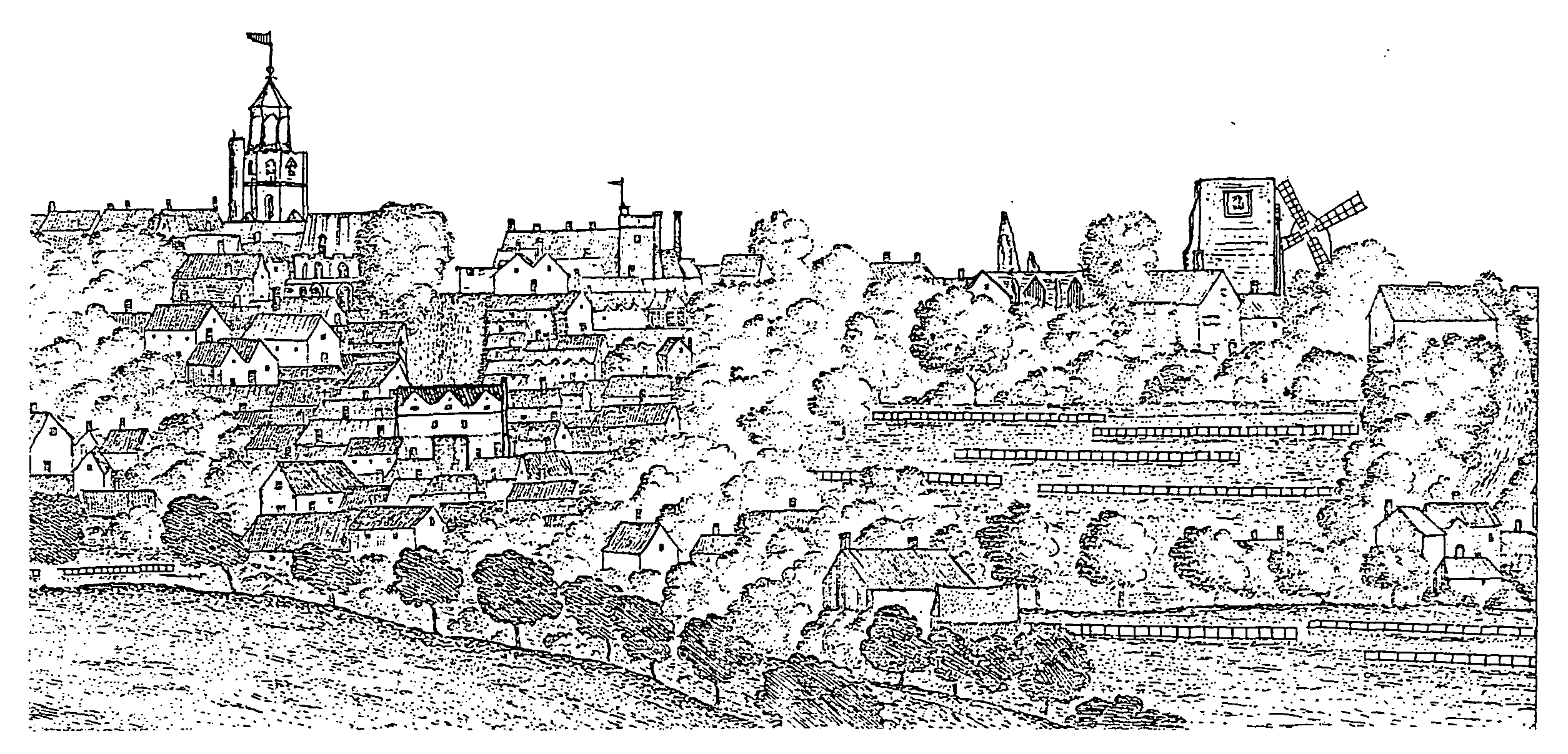
Part of a prospect of Colchester from the north, 1697 showing the tower of St. Peter's church on the left, the roofless tower of St. Mary's on the right with the windmill beside it, and tender grounds in the foreground to the right
The built-up area continued to expand, particularly in Moor Elms Lane (Priory Street) where houses were being built on the waste in 1658 and before 1672, and another house had been divided into four by 1683. (fn. 49) Building leases were granted in 1681 for land at Knaves Acre in the Hythe and for a two-storeyed house with two rooms on each floor, 'well tiled, glazed, and finished', in the postern in St. Peter's parish. (fn. 50) A house built after the siege on the site of Botolph's barn outside South gate had been divided by 1683. (fn. 51) In the central area, division of large houses continued: ten rooms, including the hall, shop, and kitchen, with four chambers above them, had been separated from the rest of the former King's Arms or Sun inn in High Street by 1682. A messuage sold in 1684 was clearly composed of rooms once part of one or two houses; it comprised the passage from the street to the yard, the low room next to the street with the chamber over it, a chamber over part of an adjoining building, a staircase leading to the two chambers, a shop, and a back buttery. (fn. 52) Other divided houses were recorded regularly in the 1680s and 1690s. (fn. 53) When a house in St. James's parish was divided in 1706, one occupant was required to build a new brick wall between the two portions. (fn. 54) By then demand for houses had eased. A 'newly built' house near North bridge was empty in 1708, and a house outside the walls in St. Mary's-at-the-Walls parish which fell down between 1673 and 1709 was not rebuilt. (fn. 55)
The market place was reorganized in 1659 and 1660, the fish market being moved from High Street to St. Nicholas's Street, and the country butchers' stalls demolished. The town butchers' shambles remained east of St. Runwald's church, but fewer butchers seem to have lived in East and West Stockwell Streets than in the 16th century and the early 17th. (fn. 56) The earlier concentrations of clothworkers near the river declined in the 17th century, but by the end of the century there was a large group of possibly industrial buildings in Ostrich Yard outside Ryegate besides that at the bottom of East Hill. (fn. 57) Fewer merchants were recorded in St. Leonard's at the Hythe, only 7 out of the 20 known to have lived in the town between 1619 and 1700, and the relative wealth of that parish declined. (fn. 58) Nevertheless in 1692 John Barrington was accused of building a warehouse on land there which should have contained no more than a fence, and by 1689 there was a 'new building' and a coalyard beside Hythe mill. (fn. 59) Improvements made to the navigation of the Colne under an Act of 1698, (fn. 60) presumably encouraged further commercial development in the early 18th century.
Despite the relative prosperity of the later 17th-century town, little public building was done. Indeed, the top storey of the castle was blown off with gunpowder in the 1690s and the reorganization of the market place seems to have involved more demolition than building. (fn. 61) The Red Row or Bay Hall was still in 1698 'a long building like stalls' on which the bays were exposed for sale. The streets, however, were then broad and well pitched. (fn. 62) The borough maintained North, East, and Hythe bridges, using stone from the partially demolished castle in 1696 and 1698, and borrowing £350 for the repair of the bridges, moot hall, and part of High Street in 1701. The town wall between Head gate and Scheregate was level with the ground c. 1700; part of East gate fell down in 1652, and more was pulled down in 1676. (fn. 63) The provision of piped water, from Chiswell, was again undertaken by individuals, not the borough; the first attempt in 1687 failed, and the waterworks did not operate until 1707. (fn. 64)
The Buildings
Most houses were timber-framed and plastered, with tiled roofs. Except in High Street and at the top of North Hill where there were three-storeyed houses, they were of two storeys with attics. Celia Fiennes observed in 1698 that 'the fashion of the country lies much in long roofs and great cantilevers and peaks'. (fn. 65) As the single-storeyed halls were rebuilt to provide more accommodation, especially when they were on the street frontage, so jettied construction, which had been usual on cross wings, became common along the whole length of frontages. The jettied northern part of no. 30 East Stockwell Street occupies the site of the medieval hall, while the southern half of the west side of Trinity Street appears to be a uniform range of jettied buildings of the 16th century. The fashion for jettying continued into the later 17th century, the latest certain example being nos. 83-84 High Street, dated 1680. Whereas the early brackets were thin and had a simple curve, the later ones were broad and often incorporated a scroll. With the fashion for long jetties and heavy brackets went one for large gables rising off the eaves. Structurally the gables are secondary to the main ridge, which is normally parallel to the street, and they are sometimes jettied like the floor below. Nos. 29-32 West Stockwell Street has jetties and large gables on a house whose three-roomed plan with a large internal stack is of a characteristically rural type.
Houses varied in size from the large town houses of the duke of Norfolk and Thomas Audley, which became the Red Lion and the King's Head inns respectively, to merchants' houses with warehouses round a courtyard, like Winsleys at the eastern end of High Street, and to two-roomed cottages or 'rents'. (fn. 66) Headgate House, the former King's Head inn, is arranged around the east, north, and west sides of a courtyard off the west side of Head Street. The tall west range has walls of brick which incorporate at the south end a doorway with four-centred head and a large first-floor fireplace of similar form, perhaps part of Audley's house or that of his successor Richard Duke, clerk of the court of Augmentations. (fn. 67) A range was added to the back in the earlier 18th century to form an assembly room for the inn. The north range is timber-framed, and probably 17th-century; the east range, which incorporates the carriageway to the street, is also timber-framed. Tymperleys off Trinity Street, claimed as the house of William Gilberd (d. 1603), incorporates the 15th-century timber-framed parlour range of a house of which the hall was probably immediately to the east and parallel to the street. The range preserved in the house to the south was probably adjacent to the service end of the hall. The hall was demolished in the 16th or 17th century, and a linking range built between the parlour and the street range of the house. The parlour range was extended westwards on more than one occasion.
Tile was used for roofs of quite modest houses by the mid 16th century, (fn. 68) and brick was used in grand houses such as the former King's Head inn and for chimneys early in the century. A borough lease of 1617 required a new house to have a tiled roof and a brick chimney, and similar leases of 1619 and 1629 prohibited the use of thatch. (fn. 69) The borough was erecting a brick building in 1618, and an L-shaped brick house of c. 1620 survived in Northgate Street in the early 20th century. Brick warehouses were built at the Hythe in 1623. (fn. 70) Nevertheless brick houses were still sufficiently unusual in the 1680s for one outside Scheregate and one in St. Mary's-at-the-Walls to be so named, and brick-built houses were so described in 1702 and 1703. (fn. 71) Before 1698 wealthy Quakers, perhaps members of the Furley family in Holy Trinity parish, had built a few brick houses 'in the London mode'. (fn. 72) The houses may have been only brick fronted, and may indeed have been those at the north end of Trinity Street whose mid 17th-century façade of orange brick decorated with a plinth and pilasters survived, encased in a later building, in the 1980s. (fn. 73) Such refronting became more general later in the century. (fn. 74) Encroachment in front of houses in Holy Trinity parish in 1696 and in All Saints' in 1697 may have been infillings under overhanging first floors. So may that of the owner of the house next to the Red Lion, who in 1703 was encroaching on the road to enlarge his shop. (fn. 75)
Most houses in the main streets had shops on at least part of their street frontage, often with a parlour or hall on the street or immediately behind it. Other buildings, including warehouses, were grouped round courtyards entered by a great gate. (fn. 76) In the later 17th century the plaster of outer walls, particularly on gables, was often decorated with pargetting, described by a French visitor in 1698 as 'all raised into ornaments stamped upon the plaster, as we impress a seal upon wax; heads of beasts, festoons, cartridges, animals, and compartments, etc. all wretchedly designed and worse executed.' An early surviving example on the gable of no. 37 North Hill is dated 1666. (fn. 77) By the late 16th century merchants had glass in their windows and wainscot in their halls and parlours. (fn. 78) Re-used heraldic glass in the Siege House in East Street in 1922, apparently from another Colchester house, contained the date 1546 and the initials ws, perhaps for William Strachey, merchant, bailiff in 1555. (fn. 79) A clothier's house beyond East bridge in 1630 had a wainscoted hall with a parlour opening off it and another room opening off the parlour. A saymaker's house in St. Botolph's parish also had wainscoting and glass windows in 1638. (fn. 80) An elaborate, early 17th-century plaster ceiling survived in a house in Maidenburgh Street in 1922. (fn. 81)
Many inns stood near the town gates, like the Maidenhead on the corner of Crouch Street and Maldon Road, recorded from 1554 until its licence was revoked for disorders in 1698. (fn. 82) Others like the Crown, where plays were performed in 1566, were at the Hythe, (fn. 83) but the main inns, like other large houses, were concentrated in Head Street, North Hill, and High Street.
The Bell, the Crown, and the New inn or the White (later the Red) Lion, stood side by side on the south side of High Street in 1522. (fn. 84) The White Lion had been built as a town house for John Howard, Lord Howard, later duke of Norfolk, in 1481 or 1482, and seems to have become an inn between 1501 and 1515 when it was the New inn, with a sign on the street. (fn. 85) It was one of three inns appointed as wine taverns in 1604. (fn. 86) The Bell and the Crown were private houses by 1597. (fn. 87) The George, presumably the surviving inn on the north side of High Street, was recorded in 1551 and 1566. (fn. 88) In 1617 a total of 331 free burgesses ate an election dinner there in the gatehouse chamber, the rose chamber, the cock chamber, the George chamber, the lower parlour, the kitchen chamber, the street parlour, the hall, and the cellar. (fn. 89) The White Hart on the south side of High Street in St. Peter's parish, another of the licensed wine taverns of 1604, was an inn in 1539 and was still one in 1705. It accommodated 156 people for an election dinner in 1579. (fn. 90) The Angel, the third licensed wine tavern in 1604, was an L-shaped building on the corner of High Street and West Stockwell Street, probably with a hall parallel to High Street. First recorded by that name in 1517, it was an inn or at least an alehouse in 1585. (fn. 91)
The King's Head, in Head Street near Head gate, was an inn in the 1550s, and in 1565 its innholder was licensed to keep a 'tennis play' as recreation for gentlemen and 'other fit persons'. (fn. 92) As many as 232 freemen ate an election dinner there in 1600, occupying 'Mr. bailiffs chamber', the little building, the lower great building, the other lower building, the street parlour, the roof parlour, Michelle's chamber, and the hall. (fn. 93) The inn was probably the house in St. Mary's parish assessed on 22 hearths in 1671, the greatest number of hearths in any house in the town. (fn. 94)