A History of the County of Gloucester: Volume 10, Westbury and Whitstone Hundreds. Originally published by Victoria County History, London, 1972.
This free content was digitised by double rekeying. All rights reserved.
Kathleen Morgan, Brian S Smith, 'Churcham: Introduction', in A History of the County of Gloucester: Volume 10, Westbury and Whitstone Hundreds, ed. C R Elrington, N M Herbert, R B Pugh (London, 1972), British History Online https://www.british-history.ac.uk/vch/glos/vol10/pp11-17 [accessed 30 April 2025].
Kathleen Morgan, Brian S Smith, 'Churcham: Introduction', in A History of the County of Gloucester: Volume 10, Westbury and Whitstone Hundreds. Edited by C R Elrington, N M Herbert, R B Pugh (London, 1972), British History Online, accessed April 30, 2025, https://www.british-history.ac.uk/vch/glos/vol10/pp11-17.
Kathleen Morgan, Brian S Smith. "Churcham: Introduction". A History of the County of Gloucester: Volume 10, Westbury and Whitstone Hundreds. Ed. C R Elrington, N M Herbert, R B Pugh (London, 1972), British History Online. Web. 30 April 2025. https://www.british-history.ac.uk/vch/glos/vol10/pp11-17.
CHURCHAM
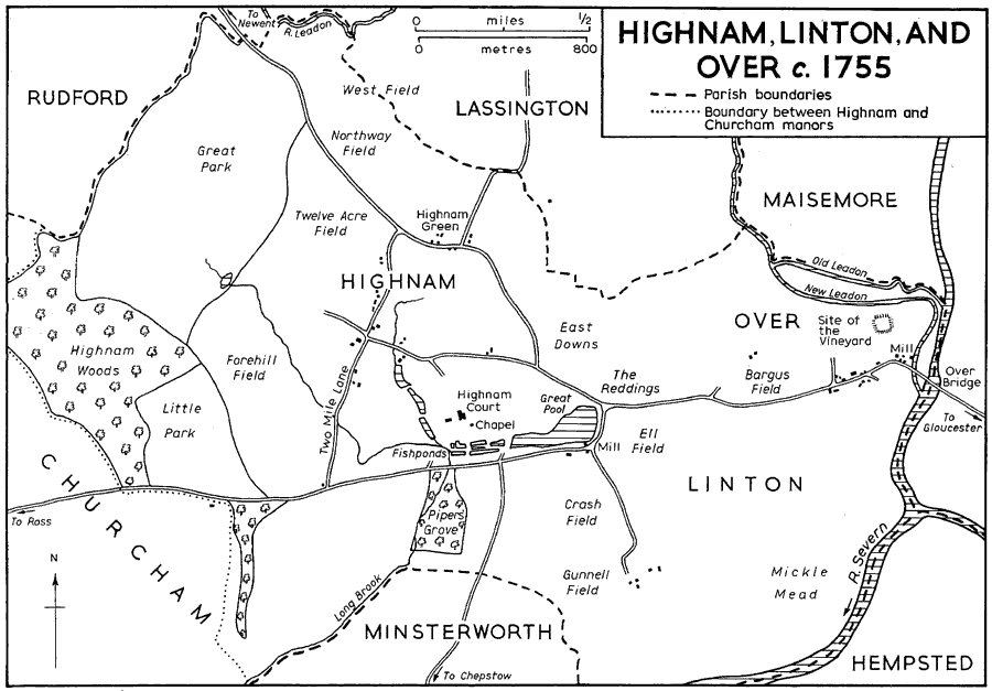
THE ANCIENT PARISH of Churcham, which included the hamlets of Highnam, Linton, and Over, lay immediately west of Gloucester and covered 4,264 a. (fn. 1) Bounded by the Severn on the east, by the Ley and Long brooks on the south, and by the River Leadon on parts of the north-east and north, the parish was elongated in shape with a large indentation on the north-west side formed by Bulley parish, (fn. 2) which has remained linked ecclesiastically with Churcham from an early period. (fn. 3) The parish of Churcham was formerly divided between two manors, Churcham in the west and Highnam, comprising the hamlets of Highnam, Linton, and Over, in the east. In 1086 the western manor, described as lying between the wood and the plain, was known as Ham and Morton, and the eastern manor was also known as Ham. (fn. 4) By 1100, however, the western manor was distinguished as Churcham, a church having been built there, and the eastern as Highnam, (fn. 5) the prefix referring to its ownership by the monks of Gloucester Abbey. (fn. 6) The name Morton, which evidently related to an area in the west part of Churcham manor, continued in use until the 14th century or later. (fn. 7) Although both manors were in the same ownership, that of Gloucester Abbey, from before the Conquest until the Dissolution, (fn. 8) they remained separate entities for the purposes of agricultural organization and manorial and parish government, (fn. 9) the distinction being further emphasized by the creation of a separate ecclesiastical parish of Highnam in 1851. (fn. 10) In 1935 Churcham was united with Bulley to form a new civil parish of Churcham, while Highnam, Linton, and Over were united with Lassington to form the civil parish of Highnam; (fn. 11) the boundary adopted between the new parishes followed that which had divided the two ancient manors. (fn. 12) Earlier, in 1882, Highnam, Linton, and Over had gained small parcels of land from Rudford and the North Hamlet division of Gloucester City. (fn. 13)
The land of the parish is fairly flat and lies mainly at under 100 ft., but there is a spur of higher ground at Rodway Hill and Highnam Woods in the centre of the parish. The Churcham division of the parish lies on the Keuper Marl, while the eastern half of the parish is formed mainly by the Lower Lias with an area of alluvium bordering the Severn. (fn. 14) A considerable area of the land was anciently woodland. In 1086 Highnam manor was said to have sufficient wood; in Churcham manor there was a wood one league long by half a league wide, and Gloucester Abbey had the hunting rights in three inclosures of woodland (haiae) there. (fn. 15) The wood of Churcham manor was presumably Birdwood, lying at its western end; it was recorded by that name from c. 1267 when the tenants of the manor were liable to woodward service. (fn. 16) The office of woodward of Birdwood was let on a long lease in 1519, (fn. 17) and there was a salaried woodward on the manor in 1779. (fn. 18) After the Dissolution Birdwood was divided between the manors of Churcham and Highnam. A part of the wood, lying south of the main Gloucester-Ross road and later known as Birdwood Coppice, descended with Highnam manor; it contained 116 a. in 1607 (fn. 19) and 110 a. in 1803. (fn. 20) The rest of the wood, mostly lying north of the main road, remained part of Churcham manor. It was evidently still well wooded in 1649, (fn. 21) but in later years it was cleared and partly settled with cottages and became known as Birdwood Common. When inclosed in 1803 the common covered 289 a. and was mostly confined to the area north of the Gloucester-Ross road and west of the lane leading north from the Birdwood cross-roads, although there were small areas of the common beyond those limits. (fn. 22) In 1803 the Dean and Chapter of Gloucester as lords of Churcham manor had 44 a. of woodland in Dean's Wood adjoining Highnam Woods on the eastern boundary of the manor. (fn. 23)
The main woodland of Highnam manor lay in the north-west part of the manor, in Highnam Woods. It may have been in that area that Gloucester Abbey was allowed to impark 80 a. in 1332, (fn. 24) and in 1607 Highnam manor included 182 a. of woodland described as lying in the park and the new park. (fn. 25) In the mid 18th century 240 a. lying in the Rodway Hill area between the open fields and the manor boundary were included in the Great Park while the Little Park further south by the Gloucester-Ross road contained 60 a.; the parks then contained only a few scattered trees but Highnam Woods, lying between and to the west of the parks and covering 93 a., were thickly wooded. (fn. 26) Considerable planting took place in the parks at the end of the 18th century, including 15,000 ash and several thousand oaks in 1798 and 1799, and larches, firs, beeches, and chestnuts in 1800; (fn. 27) by 1841 much of the Little Park was thickly wooded and a strip of woodland extended down the centre of the Great Park, other parts of which had been turned to arable fields. (fn. 28) Highnam Woods contain a pinetum, a collection of conifers which was begun by Thomas Gambier Parry in 1844 and included over 300 species by 1863. (fn. 29) A lodge in the woods, which was in existence by 1770, (fn. 30) was rebuilt in rustic style by Gambier Parry in 1868. (fn. 31) There was a smaller wood at Piper's Grove south of the main road opposite the grounds of the manor-house, Highnam Court; it was recorded from 1300 (fn. 32) and covered 21 a. in 1607. (fn. 33) Ash, sycamores, and oaks were planted there in the 1790's. (fn. 34) In the mid 18th century there was an avenue of trees to ornament the view from Highnam Court, running east of Piper's Grove to the parish boundary; it had been felled by 1841. (fn. 35).
Much of the land of the parish was formerly in open fields; inclosure of those on Churcham manor was completed by Act of Parliament in 1803, while those of Highnam manor were inclosed by a more gradual process by the mid 19th century. Highnam manor also contained a large tract of meadow land bordering the Severn in the south-east. (fn. 36) Highnam and Churcham manors were said to lie within the ancient bounds of the Forest of Dean by the earliest perambulations of the forest, in 1228 and 1282, but they were among the vills whose exclusion was sought in 1300 on the grounds that they had been afforested only in King John's reign. (fn. 37)
The River Leadon, which meets the Severn at Over at the east end of the parish, was formerly in two streams there. The surviving stream was evidently the original one, being known as the Old Leadon in 1607. The other branch, leaving the Old Leadon at the parish boundary east of Lassington Wood and taking a more southerly course to join the Severn south of Over Bridge, was called the New Leadon in 1607 (fn. 38) and was created before the mid 13th century to drive a mill at Over. (fn. 39) The New Leadon was carrying most of the water of the river in 1861 when a commission was appointed to find means of preventing the serious flooding which took place in the lower part of the Leadon valley. The works completed by the commissioners in 1867, with the object of hastening the descent of the flood water down the river, included diverting' the main flow back into the Old Leadon and building up its banks for some distance above its confluence with the Severn. (fn. 40) Subsequently the New Leadon silted up and eventually disappeared altogether, although parts of its former course were still visible in 1970. A number of small streams flow through the parish, of which the most significant has been that running west and south of Highnam Court which was used to form fishponds and ornamental lakes and to drive a mill. (fn. 41)
The parish is divided longitudinally by the main road from Gloucester to Ross and Hereford which was formerly a Roman road leading to the settlement at Ariconium near Weston under Penyard (Herefs.). East of Birdwood another Roman road branched out of it and led south of Birdwood Coppice and by way of Little London to Mitcheldean. (fn. 42) The section of the latter road in Churcham parish was still in use in 1607 when it was described as the highway from Gloucester to Mitcheldean; (fn. 43) in 1970 it survived only as a rough track or a footpath.
The Churcham division of the parish has scattered farmsteads and cottages mostly situated on lanes leading north and south from the Gloucester-Ross road. The church was built south of the main road before 1100 on a lane which became known as Church Lane, and near-by there was a manor-house at Churcham Court by the early 13th century. (fn. 44) Church Lane Farm at the north end of the lane comprises two ranges at right angles to one another, both originally timber-framed. The northern wing has been much altered at various periods but is probably of 15th-century origin; a moulded timber in the west wall is apparently the base of a cruckblade which once formed part of the central truss of an open hall. The cross-wing at the south dates from the 17th century and is of two bays with a large central chimney; the walls are mainly faced with brick or stone but close-studded timber-framing is exposed in the east gable-end. In the east bay there is a large open fireplace with a baking oven, and the fireplace in the west bay has an elaborate late Jacobean chimney-piece, perhaps brought from elsewhere. (fn. 45) In 1812 the house was called Stone End (Stoning) Farm, (fn. 46) and it may have been occupied by a husbandman of Stone End recorded in 1608. (fn. 47) By 1882, however, the name Stone End was applied to a farm-house at a small settlement on the main road to the east; (fn. 48) it consists of a two-storied brick range, apparently a rebuilding of the earlier 19th century, and an eastern cross-wing of the 17th century with exposed timber-framing. A few cottages stand near-by, including one with a 17thcentury timber frame and others of brick with decorative gables and lattice windows which were built by Thomas Gambier Parry of Highnam after he bought Stone End farm in 1871. (fn. 49) A house standing by itself further east was formerly called Cursleys Farm, its name being changed to Beauchamp House in the early 19th century. (fn. 50) There was a house on the site by 1516 (fn. 51) and perhaps by c. 1267 when William de Corsliche was one of the tenants of Churcham manor. (fn. 52) The house was rebuilt shortly before 1740 (fn. 53) as a two-storied brick building with a central gabled projection; the sash windows and the round-headed window in the central projection may have been added later.
Oakle Street is a settlement of scattered houses along a lane running south from the main road. In 1803 it contained six farm-houses and several cottages. (fn. 54) Most of the houses there were rebuilt in brick later in the 19th century. The Oakle Street Hotel north of the railway bridge had opened by 1884. (fn. 55) Churcham House, formerly Cold Comfort Farm, (fn. 56) to the north of the main road comprises a small brick cottage to which a stuccoed villa with a front of five bays and an elaborate ironwork verandah was added in the early 19th century. A field by a stream to the south-west of the house, called Upper Moat in 1803, was apparently the site of the copyhold messuage called Baron's Court or the Moat in 1649; (fn. 57) it may originally have been the site of the house of the large freehold estate held by Ralph Brown c. 1267. (fn. 58) West of the drive to Churcham House there are some brick cottages of c. 1800 on the south side of the main road and a few detached houses built on the north side of the road in the mid 20th century.
There was evidently some settlement around Birdwood in the west part of Churcham by 1439 when the tenants of Birdwoodside were mentioned. (fn. 59) Six cottages had been built on the waste of Birdwood Common by 1721 (fn. 60) and three more were added c. 1757. (fn. 61) Only one house of any antiquity survives in the Birdwood area, however, a farmhouse which stands on the lane leading south into Westbury parish and has some exposed timberframing. The other houses in the area are mainly brick buildings of the late 18th and early 19th centuries. By 1803 there were eight or nine houses, some since demolished, scattered to the east of the lane leading north from Birdwood to Bulley; they included Birdwood House by the cross-roads, a three-storey brick building with a dentil cornice, stone quoins, and splayed stone window-heads. There were then also about six houses south of the cross-roads, including Wood Farm and Birdwood Farm. There were then no houses on the main road west of the cross-roads where a few cottages were built later in the 19th century. On the main part of Birdwood Common north of the main road and west of the lane to Bulley there were about 18 scattered cottages by the time of inclosure in 1803. (fn. 62) Seven of them, all allotted at inclosure to the Dean and Chapter of Gloucester as lords of the manor, had been demolished by 1882; (fn. 63) they included a small settlement of four by a stream in the centre of the common where the only traces of habitation in 1970 were some ancient apple-trees from the orchards. The main surviving settlement of cottages on the former common, in the south-west part close to the parish boundary, was augmented by several bungalows in the mid 20th century, and a more compact group of bungalows was built in the northwest angle of the Birdwood cross-roads at the same period. By 1870 Birdwood was served by the Bell Inn at a house on the north side of the main road near the parish boundary; (fn. 64) it had closed by 1891, by which time, however, the 'King's Head' had opened near-by on the south side of the road. (fn. 65)
The settlements in the eastern half of the parish were more compact, the largest being Highnam village. Highnam Court, the manor-house of Highnam manor, (fn. 66) and its grounds lay within the fork made by two main roads, the Gloucester-Ross road on the south and on the north-east the Newent road, which was recorded as the great road from Gloucester to Newent in 1228. (fn. 67) The main village lay along the lane that linked the two roads west of Highnam Court; that lane was known as Buttington's Lane in 1607, (fn. 68) but by 1841 as Two Mile Lane. (fn. 69) At its junction with the Gloucester-Ross road at the south end there formerly stood a wayside cross, recorded in 1532 and 1607, (fn. 70) and a small cottage in the north-west angle of the junction was apparently a medieval chapel. (fn. 71) Another lane, known in its western part as Bleachfield Lane (fn. 72) and its eastern as Slade's Lane, (fn. 73) led out of the open fields west of the village crossing Two Mile Lane to join the Newent road. In 1607 there were 23 houses on or near Two Mile Lane, most of them concentrated on the north west side. Most of the tenants then held two or three houses (fn. 74) and some of the redundant houses had apparently been demolished by c. 1710 when the whole of Highnam village was said to contain only 20 houses. (fn. 75) The surviving houses in Two Mile Lane include two 17th-century timber-framed cottages, another house with a timber-framed wing, and Home Farm and Highnam Farm, two early-19thcentury brick farm-houses. In 1607 two houses stood on Slade's Lane by the pond called Shoell Pool, (fn. 76) and there were four cottages in that area in 1843, (fn. 77) later demolished. Another part of Highnam village, comprising 7 houses in 1607, was situated at Highnam Green on the Newent road by the Lassington turning, (fn. 78) where three 17th-century timberframed cottages survive with some later brick cottages.
Highnam, Linton and Over c. 1755
Highnam village was given a new focus in the early 1850s when Thomas Gambier Parry built a church, school, and glebe house (fn. 79) on the Newent road at its junction with Slade's Lane; a turreted lodge, or sacristan's house, of stone in the Gothic style, matches the other buildings and is presumably contemporary with them, and a Council House, or parish hall, was added to the group by Sir Hubert Parry in 1904. (fn. 80) In 1849, when the church was being built, the Newent road, which formerly made a westward bend to run near the site of the church, was diverted further east; the old course of the road with its steep banks was still clearly evident in 1970, its northern part being the footpath to the church. (fn. 81) Thomas Gambier Parry also built or rebuilt a number of cottages in the village. They are of brick with rustic details such as lattice windows, dormers, tall chimneys, and decorative barge-boards; Beauchamp Lodge on the Ross road, Rodwayhill Lodge on the Newent road, and another cottage at the junction of the two roads, have upper stories of mock timber-framing. A group of three by Home Farm in Two Mile Lane was designed by Jacques of Gloucester, and a pair built at Highnam Green c. 1887 were the work of Thomas's son Sidney Gambier Parry. (fn. 82) From the mid 20th century the main concentration of houses at Highnam has been sited east of the Newent road in the large Maidenhall private development; the estate was planned as a garden suburb for Gloucester in the mid 1930s (fn. 83) but only a few houses were built before the Second World War, a much greater number being added in the 1950s.
The hamlet of Over grew up in the east end of the parish by the Severn crossing at Over Bridge. There was evidently a number of houses there by the mid 13th century, (fn. 84) and a large moated mansion called the Vineyard had been built north of the main road there by the late 14th century. (fn. 85) By 1607 Over contained 21 houses scattered along the main road leading from the bridge, with the greater number on the north side of the road. (fn. 86) Only 12 houses, however, were recorded in the hamlet c. 1710. (fn. 87) The surviving cottages are all brick buildings of the late 18th and the 19th centuries; several, including two pairs with lattice windows with dripmoulds on the north side of the road, were built by Thomas Gambier Parry in the middle years of the 19th century. The Dog Inn, on the north side of the road, had opened by 1760 (fn. 88) and in the 18th century was known alternatively as the 'Talbot'; (fn. 89) parts of the building survive from the 18th century, but the inn was largely rebuilt by Gambier Parry (fn. 90) who gave it gables with decorative barge-boards. There were gallows at Over in 1754. (fn. 91) A hospital, originally the Gloucester hospital for infectious diseases, was built near the site of the Vineyard c. 1896. (fn. 92) Over Farm, a brick building some way to the west of the main hamlet, was one of the chief farms on the Highnam estate from the mid 18th century. (fn. 93) Another farmhouse south-west of the hamlet was demolished soon after 1843. (fn. 94) In 1970 Over had a considerable population living in caravans parked among the cottages.
There was a small settlement at Linton, the third hamlet of Highnam manor, by c. 1267 (fn. 95) and in 1607 the hamlet had about eight houses including the farm-houses of five of the larger copyhold estates. (fn. 96) Five houses were recorded at Linton c. 1710, (fn. 97) and c. 1755 three of the six largest farms on the manor had farm-houses at the south end of the lane leading from the Gloucester-Ross road towards the Severn. (fn. 98) By 1843 only Linton Cottages survived there, (fn. 99) a pair of late-18th- or early-19th-century brick cottages which were empty and derelict in 1970. Linton Farm, a large rectangular brick farmhouse of the early 19th century situated at the north end of the lane, may have been the new house at Linton which was under construction in 1822. (fn. 100)
There was evidently a bridge over the western branch of the Severn at Over from ancient times; it formed the end of the causeway and series of bridges which carried the main road from Gloucester to the west over the various branches of the Severn and the intervening low-lying meadows. The bridge at Over, or perhaps the bridge and causeway, was presumably the 'long bridge' which gave its name to the hundred in which Highnam manor lay in 1086, (fn. 101) and it was probably the bridge west of Gloucester which was given as the north-eastern bound of the Forest of Dean in 1228. (fn. 102) Henry 'of bridge-end' was a tenant of Highnam manor c. 1267. (fn. 103) Over Bridge was apparently being rebuilt c. 1540 when it was described as a bridge of eight arches not yet completed. (fn. 104) Repair of the bridge was the responsibility of the county, and a surveyor of the bridge had been appointed by the magistrates by 1672; (fn. 105) he was receiving a salary in 1690. (fn. 106) In the early 19th century the bridge was irregular in shape and had evidently undergone much repair. It still had eight arches, which were of varying spans, ranging between 11 and 18 ft., but five of the arches had been rebuilt in brick while the remainder were stone; the abutments to the piers were of varying shapes and sizes. (fn. 107) The rebuilding of all or some of the brick arches had evidently been carried out during major repairs in 1742. (fn. 108) In 1818 the bridge was reported to be in a bad state of repair, having been badly damaged by ice carried down river in the previous hard winter. (fn. 109) The smallness of the arches and the many thick piers also made it a hindrance to navigation. (fn. 110)
In 1825 the magistrates commissioned Thomas Telford to draw up plans for a new bridge; he submitted plans for structures of both stone and cast-iron, the plan for the stone bridge being adopted. The new bridge was situated about 100 yards above the old one and necessitated the diversion of the main road in Over and the construction of a new section of causeway on the eastern bank. The works were begun in 1826 and completed in 1829. (fn. 111) The design for the new bridge was based on a single arch of the bridge built over the Seine at Neuilly by the French engineer Perronet in 1768; it consists of a single stone arch with a span of 150 ft. and a rise of 35 ft., the angles of the underside of the arch being chamfered to cut down water resistance. (fn. 112) Soon after the completion of the bridge subsidence occurred in the eastern abutment causing joints in the masonry to open; Telford, although at the time expressing full confidence in the design and workmanship, later blamed himself for omitting to put piling as a foundation beneath the wing-wall adjoining the eastern abutment. (fn. 113) Work to repair the damage was carried out in 1830 and 1832, (fn. 114) and it was apparently not until the latter year that the traffic was turned across the new bridge. (fn. 115) A contract for the demolition of the old bridge was made in 1834 but it was not completely removed until 1836 or later. (fn. 116) The subsidence of the new bridge has continued to give concern; works to arrest it were carried out in 1857 (fn. 117) and 1881, (fn. 118) and in 1970 it was planned to demolish and replace the bridge within a few years. (fn. 119)
A short way west of the old Over Bridge the main road crossed the New Leadon by a small bridge recorded from 1525. (fn. 120) Just over the boundary of Churcham manor the Gloucester-Ross road crossed a stream by Cursley's Bridge recorded in 1522, (fn. 121) and it crossed a stream east of Birdwood by a wooden bridge in 1675. (fn. 122) The Gloucester-Ross road and the roads branching from it at Highnam northwards to Newent and southwards to Chepstow were turnpiked in 1725-6. (fn. 123) The Herefordshire and Gloucestershire canal crossing the east end of the parish was opened from Gloucester to Newent in 1795 and as far as Ledbury in 1798; in 1881 it was closed and converted into a railway which opened in 1885. (fn. 124) The railway was closed to passenger traffic in 1959 and closed completely in 1964. (fn. 125) The canal had run north and east of the site of the Vineyard and entered the Severn above Over Bridge at the point where a brick lock-keeper's cottage survives; (fn. 126) the railway left its course to run west of the site of the Vineyard to join the main South Wales line. The South Wales line was opened in 1851, the stretch of it which passes through the parish being built by the Gloucester and Dean Forest company; (fn. 127) the bridge carrying it over the Severn, designed by I. K. Brunel, was replaced by a new girder bridge in 1953. (fn. 128)
Highnam manor apparently supported the larger population of the two manors in the Middle Ages. In 1086 34 people were recorded on Highnam manor but only 9 on Churcham manor, (fn. 129) and c. 1267 97 tenants of Highnam manor were named as against 52 in Churcham. (fn. 130) By the end of the medieval period, however, the population of the parish was apparently more equally distributed between the two manors: a muster of 1539 enumerated 39 men in Highnam, Linton, and Over and 34 in Churcham. (fn. 131) In 1551 there were said to be c. 340 communicants in Churcham parish with Bulley, (fn. 132) and in 1563 50 households in Churcham parish alone. (fn. 133) About 1710 the population of the parish was estimated at c. 340; the balance of population had apparently by then shifted to Churcham manor, which was said to have 40 houses compared with 37 in the three eastern hamlets. (fn. 134) About 1775 the population of the parish was estimated at c. 309 and the accuracy of the estimate of c. 1710 was queried, (fn. 135) but by 1801 the population had risen to 529, distributed as 327 people in 74 houses in Churcham and 202 in 52 houses in Highnam, Linton, and Over. The population of the Churcham division of the parish rose to 610 by 1851; there was then a decline and it was 391 at the union with Bulley in 1935. The population of the new civil parish of Churcham was 678 in 1951, rising to 739 by 1961. The population of the three eastern hamlets had risen to 337 by 1841, distributed as 192 in Highnam, 114 in Over, and 31 in Linton; the population of the hamlets then fluctuated between c. 270 and 400 until their union with Lassington in 1935 when it was 288. In 1951 the population of the new civil parish of Highnam was 514, which the growth of the Maidenhall estate had increased to 607 by 1961. (fn. 136)
In February 1643 a large royalist force of Welshmen advanced through the Forest of Dean against Gloucester and encamped at Highnam Court, throwing up entrenchments to command the junction of the Ross, Newent, and Chepstow roads. They remained there for several weeks although harassed by Governor Massey from the Vineyard at Over. Eventually at the end of March the royalists surrendered to a combined attack delivered by Massey and a force under Sir William Waller which had crossed the Severn at Framilode after taking Malmesbury; 1,444 common soldiers and c. 150 royalist officers were taken prisoner. (fn. 137)
Some notable members of the Arnold, Cooke, Guise, and Gambier Parry families, who have in turn been resident lords of Highnam manor, are mentioned below. Jane (nee Danvers), the wife of the poet George Herbert and later of Sir Robert Cooke, (fn. 138) died at Highnam in 1662. (fn. 139)