A History of the County of Gloucester: Volume 10, Westbury and Whitstone Hundreds. Originally published by Victoria County History, London, 1972.
This free content was digitised by double rekeying. All rights reserved.
Kathleen Morgan, Brian S Smith, 'Tidenham including Lancaut: Introduction', in A History of the County of Gloucester: Volume 10, Westbury and Whitstone Hundreds, ed. C R Elrington, N M Herbert, R B Pugh (London, 1972), British History Online https://www.british-history.ac.uk/vch/glos/vol10/pp50-62 [accessed 30 April 2025].
Kathleen Morgan, Brian S Smith, 'Tidenham including Lancaut: Introduction', in A History of the County of Gloucester: Volume 10, Westbury and Whitstone Hundreds. Edited by C R Elrington, N M Herbert, R B Pugh (London, 1972), British History Online, accessed April 30, 2025, https://www.british-history.ac.uk/vch/glos/vol10/pp50-62.
Kathleen Morgan, Brian S Smith. "Tidenham including Lancaut: Introduction". A History of the County of Gloucester: Volume 10, Westbury and Whitstone Hundreds. Ed. C R Elrington, N M Herbert, R B Pugh (London, 1972), British History Online. Web. 30 April 2025. https://www.british-history.ac.uk/vch/glos/vol10/pp50-62.
TIDENHAM INCLUDING LANCAUT
TIDENHAM lies on the boundary of Gloucestershire and Monmouthshire to the east of Chepstow. The parish forms a roughly wedge-shaped area between the broad estuary of the Severn on the east and the meandering course of the Wye on the west, tapering towards the south into a narrow peninsula at the confluence of the two rivers. Crossing points of the rivers, notably the Severn passage at Beachley, played an important part in the development of settlement, and fisheries were a major factor in the economy of Tidenham from late Saxon times when it was a large royal manor. Tidenham later became part of the Marcher lordship of Striguil whose lords created a hunting chase in the manor.
Offa's Dyke, once marking the boundary between the lands of the English and Welsh, runs down the western side of the parish but excludes two areas, the peninsula of Lancaut formed by a meander of the Wye, and the Beachley peninsula on the south. Lancaut evidently remained in Welsh occupation in the 8th century when the dyke was built, but by 956 it was part of the English king's manor of Tidenham. (fn. 1) Nevertheless it retained its separate identity within the manor; (fn. 2) in the Middle Ages it was a separate ecclesiastical parish, (fn. 3) and in the later 19th century it was accorded the status of a civil parish, amounting to 218 a., being merged in Tidenham parish in 1935. (fn. 4) Beachley was also part of Tidenham manor by 956 and was apparently the area described in a Saxon survey of the manor made then or later as lying 'outside the inclosed land' and let in part to Welsh sailors; (fn. 5) it has been suggested that the small seaport existed at the time of the building of the dyke and was excluded by it in order to leave both sides of the mouth of the Wye, and the Severn crossing at Beachley, under Welsh control. (fn. 6) In 956 the bounds of Tidenham manor followed the Severn on the east and the Wye on the west while the northern and north-eastern boundary between the two rivers followed a series of landmarks some of which can be identified. (fn. 7) The boundary began at Yewtree Headland, the neck of land on the Wye opposite Tintern where the woods still contained many yews in 1969, ran on to the Stone Row, and then to White Hollow (Hwitan Heal), a name which survives in Whitewalls, a house east of Oakhill Wood; (fn. 8) it then passed through Yew Valley, Broad Moor, and Twyford, where the Piccadilly and Black brooks join at the main Gloucester-Chepstow road, (fn. 9) and came to a pill on the Severn later called Horse Pill. (fn. 10) Those bounds took no account of Madgett, an area of 311 a. lying within the northern boundary of the parish. (fn. 11) In 956 Madgett was probably already detached from Tidenham manor, for the manor was extended at 30 hides (fn. 12) as it was in 1066 when Madgett was certainly no longer part of it, being held with one of the Woolaston manors; (fn. 13) Madgett remained part of Woolaston parish until 1882 when it was merged with Tidenham. (fn. 14) The original boundary on the north-east presumably ran from Park Hill through Mereway Grove and down the Piccadilly brook to Twyford, but later an irregular arm of Woolaston parish extended into Tidenham as far as Ashwell Grange and a small detached piece of Tidenham survived within that arm near Ashwell Grove. (fn. 15) The irregular boundary appears to have resulted from allotments of tithes to the respective parishes at the inclosure by Tintern Abbey of the Ashwell Grange estate from the waste in the early Middle Ages; (fn. 16) much of the 119 a. of assarts made by the abbey in Tidenham before 1282 (fn. 17) probably lay in that area. The detached piece of Tidenham was merged with Woolaston in 1882, (fn. 18) and the boundary in that area was rationalized in 1935 when 113 a. of Tidenham between Ashwell Grange and the Piccadilly brook were transferred to Woolaston. (fn. 19) The account given here relates to Tidenham parish as it existed before the boundary changes (an area of 6,065 a., excluding river foreshore) (fn. 20) and to Lancaut; the history of Madgett is given under Woolaston.
The east and south parts of the parish are lowlying, mainly at under 100 ft., and the land is formed chiefly by the Keuper Marl. East of Sedbury, however, the Lower Lias overlying the Rhaetic beds forms an area of higher ground terminating in Sedbury Cliffs (fn. 21) which rise to c. 150 ft. above the Severn. North of Pill House a stretch of flat meadow land bordering the Severn is formed by alluvial deposits. (fn. 22) Sea-walls to defend that part against the river were being maintained in the late 13th century, (fn. 23) but in 1969 they were no longer kept up and survived only in short stretches, for in recent years a considerable area of land had been gained from the river and planted with grass; the river's action has also added land to the bank further south, in Beachley Bay. (fn. 24) In the late 17th and early 18th centuries the Tidenham manor court was concerned with the upkeep of sea-walls along the Wye on the west side of the Beachley peninsula. (fn. 25) To the northwest of the main Gloucester-Chepstow road the land rises steeply to c. 550 ft. before levelling off to form a wide plateau; on the west side the land falls even more steeply to the Wye, in places forming bare rock cliffs at 200-300 ft. above the wooded banks of the river. In the north-western part the land is formed mainly by the Carboniferous Limestone, although a strip of the Old Red Sandstone intervenes on the hill slopes to the east, and there are two considerable areas of Millstone Grit on the northern plateau and patches of Dolomitic Conglomerate on the west. (fn. 26) In 1292 the reeve of the manor sold 316½ horse-loads of coal from Tidenham Chase in the north of the parish; (fn. 27) the tenants reported that coals could be found on the chase in 1584, (fn. 28) and the lord of the manor was negotiating with miners for the exploitation of the deposits there in 1677. (fn. 29) The limestone of the parish has been extensively quarried both for local building purposes and for export from the parish. (fn. 30)
The whole parish of Tidenham lay at one time within the Forest of Dean, but by the early 13th century the lords of the manor had appropriated a great hunting chase extending across both Tidenham and Woolaston, and the exclusion of the two parishes from the jurisdiction of the forest had been established by the end of the century. The earliest record found of Tidenham Chase was in 1228 when it was said to have existed from antiquity, (fn. 31) but other jurors in the 13th century attributed its creation to William Marshal (d. 1219). (fn. 32) In the 1270s the chase was said to stretch from Chepstow Bridge to the Cone brook on the Woolaston- Alvington boundary; on the north it was presumably confined by the original Woolaston-Hewelsfield boundary, for the lord of Tidenham was reported to have extended its bounds into Hewelsfield during Henry III's reign. (fn. 33) The jurors perambulating the Forest of Dean in 1228 regarded the chase as still being part of the forest, as did those of 1282 who gave the confluence of Severn and Wye as the forest's southern boundary; (fn. 34) in 1267, however, the Cone brook had been stated to form the boundary between the forest and the Earl of Norfolk's lordship. (fn. 35) The distinction was made again in other evidence given in 1282, when it was complained that the earl's riding forester in the chase and others were accustomed to make poaching expeditions into the forest and then return to the chase where they could not be attached because it lay outside the county. (fn. 36) The exclusion of Tidenham and Woolaston from the forest was confirmed by a perambulation of 1300. (fn. 37)
The creation of the chase meant that the greater part of the parish lying north-west of the main Gloucester-Chepstow road long remained woodland and waste. Considerable encroachment on that area had evidently taken place by 1282 when various people were reported to have assarted in recent years a total of 267 a. in Tidenham, all of it being used for tillage, (fn. 38) but the available evidence suggests that at that period the open-field arable was still mainly concentrated south-east of the main road close to the Severn. By the end of the 16th century, when presumably further clearance had taken place, the open fields were mainly in the central area of the parish on the hill slopes north-east of the road. (fn. 39) A wood two leagues long and half a league wide was recorded in the parish in 1066, (fn. 40) and the thick woodlands bordering the Wye in the north-west and those on the northern boundary are evidently an ancient feature of the landscape. They were apparently once within the chase, for in 1584 the tenants of Tidenham manor complained that East Wood, Oakhill Wood, Cowshill Wood (apparently that west of Oakhill Wood), Caswell Wood, Shorn Cliff, Plumweir Cliff (later Plumweir Grove), Wallweir Wood (later the Slade), Dymwall (possibly Dennelhill) Wood, and Studdlepoll (perhaps Stowl Grove which lay east of Woodcroft) had all like the chase once been common to them, but the greater part had since been inclosed by the lord of the manor; most of the inclosure complained of had apparently taken place in the previous ten years. In 1769 the whole stretch of woods from Dennelhill round to East Wood, a total of c. 730 a., belonged in severalty to the lord of the manor. (fn. 41) At least one large wood remained within the chase, however: it was described c. 1775 as the common wood of 128 a. extending from Wallweir Wood to Madgett, and it evidently included High Wood. (fn. 42) There was probably also at one time a continuous belt of woodland on the hill slopes east of the chase: by the early 19th century as in 1969 that area had only scattered copses, but a number of the intervening fields had names which contained 'redding', denoting a clearing, while the field-names Rudgeley, Kinley, Dunley, and Mopley occurred further south-west. (fn. 43) Chapelhouse Wood (then 34 a.) bordering the Wye near Tutshill and Coombesbury Wood (15 a.) near the church also belonged to the Tidenham manor estate in 1769, (fn. 44) and there was considerable woodland further south in Sedbury tithing; in 1770 the Mead estate had 77 a. of woodland bordering the Severn there, including Millfield Grove, Cumberland Wood, and Baker's Wood, (fn. 45) and another 50 a. or more, most of it in Great Grove north of Offa's Dyke, was included in Sedbury Park at its creation in 1797. (fn. 46)
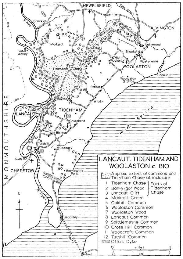
Lancaut, Tidenham and Woolaston c. 1810
By 1810 Tidenham Chase was virtually confined to the high northern plateau of the parish and covered c. 1,000 a.: its eastern boundary roughly followed the 450 ft. contour (although a number of small encroachments lay within its limits), while it was bounded on the south by Boughspring, on the west by Offa's Dyke, and on the north by the Madgett inclosures. Two detached areas, Ban-y-Gor Rocks and Lancaut Cliff, extending along the Wye respectively north and south of the Lancaut peninsula, were still regarded as part of the chase, and there were other considerable areas of waste near-by in the commons of Lancaut, Spittlemesne, and Woodcroft. The chase and the smaller commons, with Woolaston Common (evidently the remnant of the chase in that parish), a total of 1,600 a., were inclosed in 1815; by that time the open fields of Tidenham had all been inclosed by private agreement. (fn. 47) Some parts of the former chase, on the Chase Farm estate to the west, had been turned to arable by 1832, but in 1969 the portion that was farmed, like almost all the remainder of the parish, was pasture. Other parts of the chase have been used for plantations: 95 a. of the Chase Farm estate, including High Wood and Ash Grove, were planted or replanted c. 1825, (fn. 48) and in 1929 the Forestry Commission acquired Parson's Allotment and planted it with pines. (fn. 49) In 1969, however, one part, the Poor's Allotment to the east, still remained a common covered with bracken and gorse, a reminder of the former appearance of much of the north part of Tidenham parish.
Besides the chase the medieval lords of the manor had a park at Tidenham. It lay south of Tidenham village adjoining the main road on the north-west, and in the late 13th century it extended as far eastwards as the Severn. (fn. 50) It was evidently well timbered in the 1290s when bark -in one year 50 horse-loads - and wood from it were sold; (fn. 51) it may have included Park Grove on the south, which belonged to the lord of the manor in 1769. (fn. 52) The provision of new palings around the park and repairs to a building at its gateway were items of its maintenance in the late 13th century. (fn. 53) There was a parker to keep the park by 1280, (fn. 54) and in 1306, when the park contained wild beasts, he held ½ yardland by that service. (fn. 55) By 1584 the park had been divided into several parcels and was apparently leased for agriculture. (fn. 56)
The strategic position of the parish at the crossingpoints of Wye and Severn of important routes between England and Wales has left it fairly rich in ancient remains. Offa's Dyke is the major archaeological monument. In the northern part of its course through Tidenham, following the contours on the crest of the steep slopes above the Wye, it is a substantial continuous structure with a height of over 20 ft. on the river side. At the angle of a turn in the dyke is a short pillar of rock which was known as the Devil's Pulpit by 1769. (fn. 57) South of Dennelhill Wood the dyke survives only in broken and much less well-defined stretches; in some places it may have been destroyed by quarrying while in others the steep cliffs were perhaps thought to be sufficient boundary. An earlier promontory fort facing eastwards and stretching from one steep cliff edge to the other was adopted as the course of the dyke across the neck of the Lancaut peninsula. At its southern end the dyke cuts across the Beachley peninsula from Tallard's Marsh on the west, where it incorporates a small defensive work apparently made to guard a landing-place, to Sedbury Cliffs on the east; the most substantial portion of that stretch is Buttington Tump at the point where the road to Beachley cuts the dyke. (fn. 58) Several other earthworks have been identified on the hill slopes in the centre of the parish. There is a camp in Coombesbury Wood by Tidenham church and a smaller earthwork, possibly the site of an early manor-house, lies north of it. (fn. 59) The remains of another small camp lie at a place called Dinnegar just within the parish boundary south of Ashwell Grange. (fn. 60) An Iron Age fort gave its name to Oldbury field east of Garston, but its remains were mostly ploughed out in the mid 19th century. (fn. 61) Excavation at a tumulus on Tidenham Chase south of Chase Farm has revealed traces of Mesolithic and Early Bronze Age occupation. (fn. 62) A prehistoric trackway passing close to the last three sites has been traced across the parish from the Broad Stone on the Severn, which probably marked the terminal of an ancient passage of the river, to the Wye crossing at Brockweir. (fn. 63) The Broad Stone, so called by 1270, (fn. 64) is an irregularly shaped slab of stone, c. 9 ft. high, set upright in a shallow depression not far from the river bank. From it the trackway apparently ran to Stroat hamlet and then climbed the steep slopes towards the chase on the line of the footpath from Stroat Farm to Rosemary Lane; a line of large stones placed at intervals marks the course of the track for a considerable part of that section. (fn. 65) The track then followed the line of Rosemary Lane up the hill passing close to the site of the modern chapel of ease and then crossed the chase by the existing track to Beech Farm. Where it passed out of the parish on its way down Madgett Hill to Brockweir it may once have been bordered by another row of stones, providing the boundarymark of Tidenham manor in 956, (fn. 66) and the Chase Gate of a 16th-century statement of the bounds was evidently on the same part of the track; that part of the track was recorded as the horse-way from Madgett to Brockweir in 1683. (fn. 67) The Gloucester- Chepstow road crossing the parish was a Roman one, although at Tutshill its line deviated from the present road and took a more northerly course to make a crossing higher up the Wye (fn. 68) at a point where remains, thought to be of an ancient bridge, have been observed. (fn. 69) A Roman altar was found in a mound in Parson's Allotment in 1825, but excavation of the site in the 1950s revealed only traces of a building occupied at the beginning of the 18th century, and it was concluded that the altar had been brought from elsewhere. (fn. 70) It may have come from a Roman site not far away north of Boughspring which was discovered in the 1960s. (fn. 71) In 1860 George Ormerod, the local antiquary, found Roman pottery and other remains at a site in Sedbury Park, (fn. 72) and Roman coins have been found in Tidenham churchyard. (fn. 73) A monument of a much later date, a tall and narrow stone which was hauled up from the bank of the Severn and erected to commemorate the Jubilee of 1897, stands on the chase at the junction of the rides through the plantation on Parson's Allotment. (fn. 74)
The passage of the Severn between Aust and Beachley, sometimes called the Old Passage to distinguish it from the New Passage downstream, was probably in use from antiquity and was long the chief route between south-west England and Wales. It was recorded in the earlier 12th century when the de Clares, lords of Tidenham, granted quittance of the passage to the monks of Tintern, (fn. 75) and was evidently much used in 1405 when great numbers of the English and Welsh were said to resort to the near-by chapel of St. Twrog. (fn. 76) The passage was regarded as of considerable strategic importance during the Civil War, (fn. 77) and c. 1775 it was said to be much frequented by travellers between Bristol and South Wales. (fn. 78) The passage, a distance of over a mile at a point where the tides run swiftly, was a dangerous one, and its reputation, the roughness of the water, and the smallness of the passage boats deterred Defoe and his companions from making the crossing from the Aust side early in the 18th century; (fn. 79) in 1839 one of the sailing-boats used at the passage foundered, drowning all its occupants, (fn. 80) and another boat was lost with most of its passengers in 1855. (fn. 81)
The passage, as the grant to Tintern indicates, belonged at one time to the lords of Tidenham manor, who retained rights in it until the 19th century. In 1584 the lord of Tidenham was receiving a 'port rent' of 10s. from Aust and 10s. from Beachley for the passage; (fn. 82) in 1704, however, the rents were 11s., paid by the tenants of the passage from the Beachley side and by the lord of Aust manor from the other side. (fn. 83) The rents were still being paid to Tidenham manor by the partners in the ferry company in 1841. (fn. 84) The rent paid from Beachley was presumably in return for a grant of the rights belonging to that side made by the lord of Tidenham to the lord of Beachley manor, for in 1656 all those rights, which were divided into 9 equal shares, belonged to or were held from Beachley manor: 5½ shares were freeholds of the manor and were divided among four owners, 2½ shares were held on lease, and the remaining share was evidently in the lord's hands; (fn. 85) the Lewis family, lords of Beachley manor, retained its 3½ shares in 1785. (fn. 86) The division of ownership into 9 shares evidently dated from before 1414 when John Crook of Olveston held 1/9 of the passage. That share together with a house at Beachley called Crook's Place passed in the 1420s to William Philpot, (fn. 87) and was retained by his descendants who had acquired another share by 1592. (fn. 88) The Philpot family sold its two shares to Sir Samuel Astry of Henbury in 1702, (fn. 89) and another share, apparently that owned by Francis Price in 1656, was acquired by the Astry family before 1728. (fn. 90) Those three shares had passed by 1751 to Richard Chester, (fn. 91) whose family retained them in 1783. (fn. 92) Another 1½ shares of the passage were owned by William Higgins in 1656 and by William Higgins and Thomas Hitchings in 1667; (fn. 93) they descended in the Hitchings family until the mid 18th century when they were acquired by Samuel Hill (d. c. 1779). (fn. 94) The remaining 1/9 share was owned by Alexander James in 1656 and evidently descended with his Tidenham estate, being owned by Charles Williams c. 1775. (fn. 95)
An inn at Beachley called the 'Green Dragon' belonged to the Philpots in 1651 (fn. 96) and descended with their portion of the passage; by 1728 its name had been changed to the 'Ostrich' (fn. 97) and by 1783 it was known as the Beachley passage house. (fn. 98) It stood by the river to the south of Beachley village (fn. 99) where an approach was possible for the boats between two projecting shelves of rock, and c. 1800 it was a large building with a projecting bay at the front standing above a stone embankment which incorporated a short slipway to the water's edge. (fn. 100) Another inn at Beachley called the 'George' also belonged to the Astrys in 1728, (fn. 101) and the two inns with their three shares in the passage and passage boats were leased by the Chesters to Thomas Hitchings in 1751, and to Samuel Hill in 1766 (fn. 102) who by virtue of his possession of half the shares apparently operated the passage. In 1767 Hill advertised that he had provided a movable landing-stage from which horsemen could ride on board the passage boats, and he kept postchaises and a post-coach for hire; travellers on the Aust bank could summon a boat from Beachley by a smoke signal. (fn. 103)
In 1825 a new era opened for the passage with the formation of the Old Passage Ferry Association by James Jenkins of Chepstow, Richard Jenkins of Beachley, and Oliver Chapman of Chepstow. (fn. 104) James Jenkins had presumably succeeded to the ownership of the lord of Beachley's 3½ shares and also of the passage house which Samuel Jenkins had owned in 1815; (fn. 105) the other owners of the rights on the Beachley side and the owners on the Aust side were presumably bought out. The Duke of Beaufort, lord of Tidenham manor, apparently sponsored the venture. The company built new stone piers on both banks, the Beachley one some way further south than the old landing-place below the passage house, and commissioned a steamboat which began to ply in 1827. (fn. 106) By virtue of those improvements the company achieved the transfer of most of the cross-Severn mail routes from the rival New Passage downstream at St. Pierre, and c. 1830 traffic over the Old Passage was said to have greatly increased with stage-coaches passing through Beachley six times a day. (fn. 107) It apparently did not achieve immediate financial success, however, for in 1830 the Tidenham vestry, in view of the importance of the passage to the parish, postponed rating the improvements until the company had overcome its 'present difficulties'. (fn. 108) A second steamboat was acquired in 1832 although a number of sailing boats continued to be used in addition. (fn. 109) The advent of railways, in particular the opening of the South Wales railway in 1852, brought a sharp decrease in the traffic at the passage; one of the steamboats was sold c. 1854 and the other made only occasional crossings until it was scrapped in 1860. Eventually the passage was closed altogether. It gained a new lease of life, however, with the growth of motor traffic: it was re-opened in 1926, and a limited company operated it with diesel carferries from 1931 until the opening of the Severn Bridge in 1966.
The idea of replacing the Old Passage with a bridge was apparently first advanced by Telford in 1824 and the scheme was revived several times during the 19th and earlier 20th centuries. (fn. 110) The Severn Bridge was built between 1961 and 1966 to carry the M4 motorway into South Wales. It is a great steel suspension bridge with slender towers rising to 400 ft. above the river and a central span of 3,240 ft.; it was designed under the direction of Sir Gilbert Roberts by Freeman, Fox & Partners and Mott, Hay & Anderson. (fn. 111) The bridge dominates the landscape of the south part of Tidenham parish but otherwise has affected the parish little as there is no access to it from Beachley, the roadway continuing by a viaduct over the Beachley peninsula and by a smaller bridge across the Wye into Monmouthshire.
The survey of Tidenham made in the later 10th or earlier 11th century extended the manor at 30 hides lying in six divisions: there were 12 hides at Stroat, 5 at Milton, 6 at Kingston, 3 at Bishton, and 3 at Lancaut, while the remaining hide, the area described as lying 'outside the enclosed land', was apparently at Beachley. (fn. 112) If, as seems possible, the hide at Tidenham contained c. 100 a., (fn. 113) the survey included only c. 3,000 a. or roughly half the parish, presumably the land under cultivation lying mainly in the south and east. If that was the case, however, the Lancaut division was larger than the 218 a. later confined within the boundary of Lancaut parish, which ran across the neck of the peninsula at about its narrowest point. (fn. 114) Of the other divisions Stroat, a name apparently deriving from the Roman road, (fn. 115) survived as the name of a settlement on that road and of the north-eastern tithing of the parish, and Bishton survived as the name of the western tithing of the parish although as a settlement-name it was confined to a small group of houses near the centre of the tithing. Milton evidently included the central area of the parish extending between Wye and Severn which was later comprised in the tithings of Churchend and Wibdon, the former centred on the settlement at the church and the latter on farmsteads on the main road to the north-east; the name Milton remained in use for that division of Tidenham manor in 1584, (fn. 116) although Wibdon was being used as a settlement-name by 1306 (fn. 117) and Churchend by 1560. (fn. 118) Kingston, with fisheries on the Severn and Wye and including one hide lying 'above the dyke', was evidently the later tithing of Sedbury. The name Sedbury was used for a settlement there by 1448 (fn. 119) and for the tithing by 1584; (fn. 120) its usual form until the early 19th century was 'Sudbury' and its derivation ('south fortification') (fn. 121) may be taken from either Offa's Dyke or the Roman settlement in Sedbury Park. The name Beachley was in use for the settlement in the sixth tithing of the parish by 1289. (fn. 122)
In Saxon and medieval times the settlements other than Lancaut were evidently concentrated in the east and south of Tidenham parish and are represented by the farmsteads lying scattered along the Gloucester-Chepstow road and the road leading southwards from it towards Beachley; the settlement around the passage at Beachley probably constituted the only nucleated hamlet. In the 17th and 18th centuries small settlements grew up in the centre of the parish on the fringes of the chase, notably at Boughspring, and in the west around the commons at Spittlemesne, Woodcroft, and Tutshill, but it was not until the 19th century that the pattern of settlement was seriously altered by the growth of large compact hamlets at Tutshill and Woodcroft. The concentration of houses in the west of the parish was intensified in the early and mid 20th century with developments at Beachley, Sedbury, and Tutshill and more scattered building north of Woodcroft, while the ancient eastern settlements were little altered. Few houses of any antiquity survive in the parish. There are a few 17th-century farm-houses but most of the farm-houses and cottages were built or rebuilt in the 18th and 19th centuries and almost all are in the local dark grey stone; only one or two houses which showed signs of having been originally timber-framed structures were found in 1969.
Churchend hamlet lying north-west of the main Gloucester-Chepstow road roughly at the centre of the parish was presumably one of the earliest settlements. The parish church was built there before 1071 (fn. 123) and a manor-house apparently existed there earlier. (fn. 124) Three houses at Churchend were mentioned in 1614. (fn. 125) Day House Farm adjoining the main road is probably on the site of the medieval manor dairy; (fn. 126) it was recorded by that name in 1743, (fn. 127) but the present two-storied house of rough-cast stone dates, like most of the farm-houses of the Tidenham manor estate, from a rebuilding in the late 18th or early 19th century. A pair of stone cottages to the south-west were built by the Marling estate in 1902. (fn. 128) An inn called the 'Sugar Loaf' had been opened at a cottage on the main road east of Churchend by 1746 (fn. 129) and continued in business until 1863 or later. (fn. 130) Tippets, a house further along the road, was recorded as a farm-house on the manor estate from 1769, (fn. 131) but the house, which in 1813 was of stone partly tiled and partly thatched, (fn. 132) had been demolished by 1969 and only a barn remained at the site. Philpots Court, a farm-house of c. 1800 to the north, may be on the site of a house occupied by a family of the name c. 1560. (fn. 133) Pill House Farm, which stands above an inlet of the Severn, was evidently the Pill Farm on the manor estate mentioned in 1584, (fn. 134) and was described as a large old farm-house in 1813; (fn. 135) the present stone house with sash windows presumably dates from a rebuilding shortly afterwards.
A number of small settlements grew up in the north part of Churchend tithing. There were six or seven cottages at Cross Hill, north of the church, by 1815, when a small roadside common there was inclosed; (fn. 136) other houses were added in the mid 20th century. There was a house at Netherhope by 1655, (fn. 137) and a stone house and a cottage stood there by the mouth of the railway tunnel in 1969. Boughspring, known until the early 19th century as Bowels Green, (fn. 138) originated as a squatter settlement on the southern edge of Tidenham Chase; three cottages built on the chase which were presented in the manor court in 1712 were perhaps in that area. (fn. 139) A house called Caine's Hill House had been built there by 1670 east of the lane leading from Wibdon, (fn. 140) and by 1815 there were c. 10 cottages scattered around the junction of the lanes at Boughspring. (fn. 141) Caine's Hill House had been demolished by 1969 and on the opposite side of the road a pair of cottages and a Wesleyan chapel were replaced in the 1960s by new houses. (fn. 142) Boughspring House, in the southwest angle of the junction where there was a house by 1815, was rebuilt as a large residential house of stone in Tudor style c. 1900. Wallhope Farm to the west was rebuilt at about the same period. (fn. 143) In the mid 20th century several houses were built along the lane leading from Boughspring past Wallhope Farm. At the beginning of the 18th century 18 families were recorded in Churchend tithing, (fn. 144) and only two more were enumerated c. 1775; (fn. 145) the growth of the settlements in the north had caused a considerable rise in the population of the tithing by 1841 when there were 253 inhabitants in 43 houses. (fn. 146)
A group of farms on the main road evidently represents the earliest settlement in Wibdon tithing. In 1614 eight houses were recorded at Wibdon held from Waldings manor, (fn. 147) in which much of the tithing was included from the 13th century, and most probably stood on or near the road. Either Wibdon Farm or High Hall opposite may occupy the site of the chief house of Waldings manor. (fn. 148) Hanley House near-by was presumably the farmhouse called Hanleys recorded from 1618, (fn. 149) but it was rebuilt as a gabled stone house by Thomas Morgan of Tidenham House in 1866. (fn. 150) A few 18thor early-19th-century cottages also stand along the road; the pair opposite High Hall was recorded in 1804. (fn. 151) Sixteen families were enumerated in Wibdon tithing c. 1710, (fn. 152) but 26 families c. 1775. (fn. 153) The increase was probably accountable in part to the building of cottages on Rosemary Lane (fn. 154) leading from High Hall up to Tidenham Chase, its northern part on the line of a very ancient route; (fn. 155) it was presumably the lane from Wibdon to the chase on which an inn called the 'White Hart' stood in 1584. (fn. 156) A house called Garston on Rosemary Lane was recorded in 1764, (fn. 157) and by 1815 there was a scattering of stone cottages higher up the lane. (fn. 158) A new farmstead, Chase Farm (later Chase House), and a few cottages were built on the chase soon after its inclosure in 1815, (fn. 159) and more cottages, in a fairly compact settlement east of Chase Farm, were added in the middle and later years of the 19th century. (fn. 160) The settlement developed around the southern end of the track called Madgett Road which led northward from the Chepstow-Coleford road to join the line of the prehistoric trackway, while another track, called Abbey Road in 1815, (fn. 161) branched out of Madgett Road towards the ferry at Tintern, (fn. 162) crossing Offa's Dyke near the Devil's Pulpit, presumably at the place that was called Abbey Gate in 1755; (fn. 163) the southern stretch of Madgett Road, the only part of the two routes surviving to become a metalled road, was later called Miss Grace's Lane after the occupant of Chase House during the earlier 20th century. (fn. 164) By 1841 the settlements in the north part of Wibdon tithing had increased its population to 176 in 33 houses; (fn. 165) a school was built to serve the settlement in the chase area c. 1850 (fn. 166) and a chapel of ease in 1888. (fn. 167)
The settlement at Stroat grew up where the main Gloucester-Chepstow road was crossed by the ancient trackway from the Severn; in the earlier 18th century a track, variously described as a highway and a horse-path, still linked Stroat to the river (fn. 168) and the landing-places and fisheries at the two inlets known by the 16th century as Horse Pill and Walden Pill. (fn. 169) The hamlet was linked to Churchend by an alternative route running through the fields to the north of the main road by Garston and Philpots Court; it was known as Hoball Lane in 1630 and was described as the way from Stroat to Tidenham church. (fn. 170) Most of the seven customary tenants holding land at Stroat from Tidenham manor in 1584 (fn. 171) and the 14 families recorded in the tithing c. 1775 (fn. 172) evidently lived in houses on the main road. The settlement there has remained a small one. There are only two houses of any size, the 17th-century Stroat Farm on the north-west of the road and the 18th-century Stroat House (fn. 173) on the opposite side, and there are a number of 18th- or early-19th-century cottages. A cottage opposite Stroat House was the George Inn from at least 1744 and was for many years the meeting-place of the Tidenham manor court. (fn. 174) The inn, which in the later 19th century was known as the 'George and Dragon', was closed c. 1900. (fn. 175) At Clap-y-Atts between Stroat and Woolaston a pair of stone cottages with mock timber-framing in the gables was built by Sir Percival Marling in 1905 to house disabled soldiers of his regiment. (fn. 176) The population of Stroat tithing had risen to 176 in 37 houses by 1841, (fn. 177) apparently the result of scattered building both on the main road and in the north part of the tithing after inclosure of the chase. Only one house had apparently existed before the 19th century in the chase area of the tithing, the Chase House, a stone cottage faced in plaster standing by the Coleford road, which had been built by 1769. (fn. 178) It was an inn in the early 19th century, (fn. 179) but in 1920 the forester on the Marling estate lived there while the estate carpenter and mason occupied a pair of stone cottages further north (fn. 180) built by Sir William Marling in 1898. (fn. 181)
In the medieval period most of the houses of Sedbury tithing appear to have been in the north part of the tithing where Sedbury Lane, branching towards Beachley out of the Gloucester-Chepstow road, met a road leading from the Severn at Pighole Pill (fn. 182) and probably continuing across Sedbury to Chepstow Bridge. The latter road was evidently connected with the river passage from Shepherdine on the east bank of the Severn, which was recorded in 1563 (fn. 183) and was still in regular use by people going to market at Chepstow in the mid 19th century when, depending on the state of wind and tide, either Pighole Pill or Slimeroad Pill, south of Sedbury Cliffs, was used as the western terminal. (fn. 184) The road to Pighole Pill was presumable the highway from Sedbury to the Severn recorded in 1666, (fn. 185) and in 1712 it was known as Bird's Lane. (fn. 186) In 1815 another track existed running south along the bank from Pighole Pill, connecting it with Slimeroad Pill and the road to Beachley. (fn. 187) There was a village cross at the junction of Sedbury Lane and Bird's Lane in 1499 and at least three houses then stood north-east of the junction where in 1969 were Tump Farm and some rough-cast cottages of the late 18th or early 19th century. By 1499 there was also a house at Anwards on Bird's Lane, (fn. 188) where the ruins of a stone house remained in 1969. Lowcroft House mentioned in 1583 evidently stood further north near Lowcroft Barn. (fn. 189) A house to the south of the junction, later called Old Sedbury, was recorded from 1638, (fn. 190) and was rebuilt as a pair of stone cottages by George Ormerod of Sedbury Park in 1866. (fn. 191) Sedbury Farm to the west of Sedbury Lane was one of the farm-houses on the Tidenham manor estate in 1769. (fn. 192) The Mead further north was rebuilt c. 1770 when it was the centre of a considerable estate. (fn. 193)
An early settlement further south was at Badams Court where the manor-house of Beachley manor, which once included much of Sedbury tithing, was located in the early 14th century. (fn. 194) The south part of the tithing was formerly known as Barnes, a name which sometimes appears as 'Barons' (fn. 195) and was apparently an allusion to the baronial status claimed by John ap Adam, lord of Beachley manor. (fn. 196) A house at Barnes standing near the junction of Sedbury Lane and the road from Tutshill was recorded in 1638, (fn. 197) and Barnes Farm, to the southeast of the junction, from the early 18th century. (fn. 198) Buttington Cottage further south near Offa's Dyke belonged to the Hitchings family in 1716, (fn. 199) and later served as one of the lodges of Sedbury Park, (fn. 200) the large mansion to the east which was the chief house at Sedbury from the beginning of the 19th century. (fn. 201) A house had been built at Pennsylvania, west of Buttington Tump, by 1748 (fn. 202) and was rebuilt as a gabled stone building by George Ormerod in 1851. (fn. 203) In 1746 there was an inn called the 'Cock' at Bunker's Hill on the road from Tutshill. (fn. 204) Sedbury tithing with 26 families was the most populous of the six tithings of the parish c. 1710, (fn. 205) but there had been a fall in population by the 1770s when 19 families were enumerated; (fn. 206) in 1841, however, the tithing had a population of 173 in 32 houses. (fn. 207)
During the 20th century the western part of Sedbury tithing has been transformed. A prisonerof-war camp was built north-east of the road to Tutshill in the First World War, and at the end of the war a semi-circle of houses in terraces of varying sizes, known as Pennsylvania Village, was built on Offa's Dyke to house workers at a ship-building yard at Beachley. (fn. 208) Council and private housing development followed and by 1969 the area between Pennsylvania Village and the camp was occupied by a large modern settlement with a public house, school and shops.
The village of Beachley in the southern peninsula of the parish grew up around the Severn passage and most of its inhabitants formerly gained a living by the passage and the several inns which served its users, or by other callings connected with the river. The road leading through the village was recorded as the highway leading to the passage in 1429; (fn. 209) it followed a fairly straight course along the river bank to the passage house until 1893 when it was diverted from the east to the west side of a large house called Beachley Lodge. (fn. 210) Beachley was evidently a fairly compact settlement by 1624 when the road was called Beachley village street, (fn. 211) and in 1675 it was described as a small village with two very good inns. (fn. 212) One of the inns was evidently the passage house, then called the 'Green Dragon', and the other either the 'George', (fn. 213) or the 'Ship' which existed in addition to the other two inns in 1728. (fn. 214) Beachley tithing contained 20 families c. 1710 (fn. 215) but there had been a decline in population by c. 1775 when only 11 families were enumerated. (fn. 216) The village expanded in the late 18th and early 19th century, however, and by 1841 the tithing contained 224 inhabitants in 39 houses, (fn. 217) and a chapel and school had been built. (fn. 218) The most substantial surviving house, Beachley Farm, a rectangular building of two stories and attics with sash windows, dates from the early 19th century. Beachley Lodge was also built at the same period and was known as the New House in 1815; it was then occupied by Richard Jenkins (d. 1834) (fn. 219) who was one of the founders of the Old Passage Ferry Association, (fn. 220) and after c. 1850 it was the home of Robert Castle Jenkins and his successors in the Beachley manor estate. (fn. 221) By 1815 an outlying group of two or three cottages had been built on the road to the north of the village, and in 1824 they included the Salmon Inn. (fn. 222)
The expansion of the village in the early 19th century was evidently due in part to the improvements at the passage in the 1820s, and c. 1830 the success of that venture encouraged the promotion of a scheme, never realized, to develop Beachley as a watering-place with a promenade and dwellinghouses extending round Beachley Point. (fn. 223) During the earlier 19th century customs officers occupied a cottage in the village (fn. 224) (still known as the Custom House in 1969) and manned a look-out post on Beachley Point; (fn. 225) shipping bound up river to Gloucester put in to Beachley Bay to be searched. (fn. 226) In 1841 a tide-surveyor, a mail-inspector, and an engineer (who presumably worked the passage steam-boats) were also living in the village, (fn. 227) while other inhabitants connected with the river and its trade in the 19th century were mariners, pilots, shipwrights, and fishermen. (fn. 228) An annual regatta was held off Beachley from 1839. (fn. 229) A small stone building with pedimented windows facing down the ferry pier, and apparently built at the same time, (fn. 230) was the Beachley Coffee Rooms in the late 19th century. (fn. 231) During the First World War a large national ship-building yard was established to the west of Beachley village and the inhabitants were temporarily evicted from their homes; the shipyard never completed a vessel and the scheme was abandoned soon after the war. (fn. 232) By 1927 the site had been taken over by the Army Apprentices College, (fn. 233) the extensive buildings of which dwarfed the village in 1969. Several of the older houses of the village have been demolished, including four cottages which stood south of the ferry pier, (fn. 234) the old passage house, and Beachley Lodge; Beachley has been further altered in character by a line of bungalows almost linking it with Sedbury and by the dominating structure of the Severn Bridge.
The original settlement in Bishton tithing was apparently the small group of houses lying around the junction of three lanes, Rye Lane (fn. 235) coming from Cross Hill, Cambridge Lane (fn. 236) leading from the Chepstow-Coleford road in the west, and a lane running north from the Gloucester-Chepstow road. In 1769 the houses there included Bishton Farm to the west of the junction, Rye Farm to the east, and another farm-house to the south. (fn. 237) In 1813 all three were stone houses with tiled roofs, as Bishton and Rye Farms remained in 1969, although faced with rough-cast; the third farm-house was in ruins in 1813 (fn. 238) and was later demolished. Another farmhouse standing some way to the west on Cambridge Lane was known as Old Bishton Farm in 1830. (fn. 239) Wirewood's Green to the south-west was apparently an early settlement: Roger of Wirewood was reeve of Tidenham manor in 1270, (fn. 240) and in 1306 a number of tenants of the manor had that surname. (fn. 241) A house at Wirewood's Green was recorded in 1565, (fn. 242) and was described as a mansion house in 1677. (fn. 243) The present house, which consists of a central block flanked by gabled wings, may be basically of the 16th century, but apart from massive chimneys on the outer wall of each wing there are now no features remaining which clearly date from before the 18th century. In 1769 the house had a long avenue of trees leading southwards to a gate on the main road (fn. 244) but only part of the avenue survived in 1969 because of the recent construction of an approach road for a new housing estate. The only house near the crossroads at Tutshill before the 19th century was apparently Tutshill Farm (fn. 245) recorded from 1655. (fn. 246) Chapel House Farm, which stood further west in 1769 on the old road down to Chepstow Bridge, (fn. 247) may have been the house belonging to the near-by chapel of St. David in 1530. (fn. 248) A house had been built on the common adjoining the Sedbury road south of Tutshill by 1712, (fn. 249) and there were two or three there by 1815, including Severn Lodge, (fn. 250) a three-storied house with a front of three bays and a central pedimented doorway. There were only a few houses in the north of the tithing scattered along the road to Coleford before the 19th century. They included a house called Penmoil and another called Dunley House, both recorded in 1655 and standing west of the road at Woodcroft, one at Broadrock further north mentioned in 1719, (fn. 251) and one built by 1762 on Spittlemesne Common, (fn. 252) perhaps the house there which was the inn called the 'Travellers' Rest' by 1815. (fn. 253) Powder House Farm standing east of the road between Tutshill and Woodcroft was one of the farm-houses on the Tidenham manor estate in 1769 (fn. 254) and was a stone house with a thatched roof in 1813. (fn. 255) At least one cottage had been built on the common east of the road at Woodcroft by 1712, (fn. 256) and by 1815 there was a small settlement of six or seven cottages there. (fn. 257)
Bishton tithing had 16 families c. 1710 (fn. 258) and 19 c. 1775; (fn. 259) by 1841, however, it was easily the most populous of the tithings with 425 inhabitants in 85 houses and there were also 21 empty houses, presumably just built. (fn. 260) By the middle of the century the tithing's new population required a chapel of ease and a school, which were built on the road between its two growing centres at Tutshill and Woodcroft. (fn. 261) The expansion of Tutshill had begun by 1828 when building-plots north-east of the cross-roads there were sold, (fn. 262) and by 1843 there were houses extending along the roads to the north and east with the Cross Keys Inn at the corner. (fn. 263) The houses built there included Gloucester House on the east, a small two-storied stuccoed villa with shutters to the ground-floor windows and an ironwork verandah, and Ty-Gwilym on the north, a similar house with architraves to the windows and a more elaborate verandah. There was another period of expansion in the late 19th century and early years of the 20th when the southern side of the Gloucester-Chepstow road east of the cross-roads was developed with detached and semi-detached houses, a row of houses in pairs or terraces was built on the north of the road to Tutshill railway halt, and other houses were built around the minor roadjunction to the north of the cross-roads; many of the houses of that period are in the local stone but brick was also being used for the first time in quantity. By 1856 Tutshill was already a minor centre with two public-houses, a shop, a post office, a solicitor's office, and a private school, (fn. 264) and in 1894 22 private residents and 6 lodging-houses at Tutshill were listed. (fn. 265) Expansion continued during the 20th century and there was a major increase in the population in the middle years of the century with new housing-estates on the road to Tutshill railway halt, between the cross-roads and Wirewood's Green, and to the south on the Beachley road. There is a small group of houses by the Wye below Tutshill: it includes Wyecliffe House by Chepstow Bridge, a three-storied late 18th-century house with sash windows and a ground-floor verandah, and, on the promontory to the west, a row of brick houses said to have been built c. 1900 with the product of the near-by brickyard, (fn. 266) and some modern bungalows. During the 19th century there was also steady development at Woodcroft which had become a sizable hamlet by the end of the century with cottages, although still reasonably scattered, covering much of the area of the former common, and some more widely spaced along the road to the north. Most of the single and paired cottages there are faced in rough-cast and most are presumably built of stone as are two larger terraces. In the mid 20th century numbers of detached houses were built along the road running northwards from Woodcroft and up onto the former chase, their owners attracted by the views over the Severn to the east and the dramatic Wye scenery on the west.
A feature of the western part of the parish is the number of large residential houses set in spacious grounds, most of them built in the earlier 19th century. The house formerly called Tutshill House (fn. 267) but in 1969 St. John's-on-the-Hill, standing southwest of the cross-roads at Tutshill, was in an unfinished state in 1806 when a builder contracted with Sir George Bolton for its completion. (fn. 268) It is a two-story stone house having a front with flanking bay windows and an ironwork balcony at first-floor level; a contemporary stable-block with an arcaded front stands near-by. In 1969 the house was a boys' preparatory school. Castleford, further west commanding a view across to Chepstow castle, was built before 1879; (fn. 269) it comprises a Gothic house built of red and blue brick, to which a stone garden front in Jacobean style was added by the owner, W. R. Lysaght, in 1912. (fn. 270) Other additions were made c. 1960 when the house became a sales and service depot for a lawn-mower company. (fn. 271) Tutshill Lodge on the south of Tutshill had been built by 1843; (fn. 272) it is a square two-storied stuccoed house with a three-bay front with a central doorway and flanking windows set in arched recesses. At Penmoil, west of Woodcroft, there was a house called Penmoil Cottage in 1815, (fn. 273) perhaps on the same site as that recorded in 1655, (fn. 274) and in 1890 Penmoil was a fairly large two-story house with bay windows. (fn. 275) It was rebuilt early in the 20th century (fn. 276) as an ornate house of stone with mock timber-framed gables and a Gothic porch. There was a house at Eastcliff south of Penmoil by 1815, (fn. 277) and it was apparently rebuilt or remodelled c. 1830; (fn. 278) Eastcliff was again rebuilt in the 1920s (fn. 279) as a two-story stone building in Queen Anne style. Dennel Hill, a stone house of two stories perched on the cliffs above the Wye, had been built by 1840, (fn. 280) and East Vaga, further north, by 1856. (fn. 281)
The parish of Lancaut, which apparently had a church from Saxon times, (fn. 282) was evidently once a settlement of some size. In 1306 Tidenham manor had 10 tenants at Lancaut. (fn. 283) In 1551 the parish had c. 19 communicants, (fn. 284) and in 1563 there were 5 households there. (fn. 285) There were four families living at Lancaut c. 1710 (fn. 286) and by 1750 it had only two inhabited houses. (fn. 287) One of the houses belonged to Mr. Jones and was evidently the farm-house standing on the north side of the road there which belonged to the Tidenham House estate in 1815; (fn. 288) the present house there is a 19th-century stone cottage. The other house in 1750 belonged to Mr. Stevens, of a family who were recorded at Lancaut from 1559, (fn. 289) and was apparently Lancaut Farm standing south of the road. It comprises a twostory range of rough-cast stone with diagonally-set stone chimneys and sash windows to the garden front; it apparently dates mainly from the 18th century although there is some evidence of an earlier timber-framed structure at the south end of the house. The only other house in the peninsula in 1815 was a building, described as a cottage and fish-house, on the river bank south of the church; (fn. 290) it was apparently unoccupied in 1839 (fn. 291) and only a few stone ruins remained in 1969.
The Gloucester-Chepstow road was the chief highway through the parish and the one most often recorded as needing repair; in 1668 the inhabitants of Bishton were required to repair a stone bridge on the road, and a causeway on another part was to be repaired by the adjoining tithings in 1697. (fn. 292) The road was turnpiked in 1757-8 together with the road leading out of it at Tutshill to the Beachley passage. (fn. 293) Turnpike houses were built at the Tutshill crossroads and north of Beachley village. In 1769 the main road to Chepstow made a sharp turn to the south just beyond Tutshill and led directly down the hill to Chepstow Bridge, (fn. 294) but by 1815 an easier route curving round to the west had been substituted. (fn. 295) The old road, a steep descent between high stone walls, was later closed to traffic.
Chepstow Bridge, carrying the main road across the Wye, was recorded from 1228. (fn. 296) About 1540 the bridge, a timber one, was described as ruinous; (fn. 297) it may have been rebuilt in the 1540s. (fn. 298) In 1576, however, it was described as a great wooden bridge in great decay when an Act was passed making Gloucestershire and Monmouthshire responsible for the repair of their respective halves of the bridge. (fn. 299) Neglect continued, however, and in 1606 the bridge was said to have fallen down and been carried away; the earlier Act was then replaced by another which included a provision for penalties on the magistrates for failure to levy rates for the repairs. (fn. 300) By 1673 maintenance of the Gloucestershire side of the bridge was in the hands of salaried surveyors who carried out considerable repairs between then and 1681; (fn. 301) in 1676 the surveyors were empowered to build a house in which timber and other materials could be stored, (fn. 302) and in 1703 they had the use of a warehouse and a boat. During the 18th century individuals contracted with the county to maintain the bridge for terms of years. (fn. 303) At the beginning of the 18th century the bridge comprised a wooden decking carried by a central stone pier and five piers on either side each formed by a number of timber piles; the height of the piers was considerable, to allow for the high rise of the tides. (fn. 304) The Monmouthshire half of the bridge was rebuilt as four stone arches in 1785, but the Gloucestershire half remained timber until 1815 when a complete rebuilding of the bridge was begun to the designs of John Rennie. The new bridge, opened the next year, comprises five cast-iron arches carried on stone piers and has a central span of 112 ft. (fn. 305)
The South Wales Railway through the parish was opened as far as a temporary station near Churchend in 1851 pending the completion of the bridge to carry the line over the Wye. The bridge was opened to two-way traffic in 1853. Designed by I. K. Brunel, it is a tubular suspension bridge with a span of 300 ft. from the cliff-top on the Tutshill side to the first pier on the much lower Chepstow bank, and three further land spans each of 100 ft. (fn. 306) In 1876 the Wye Valley Railway was completed, branching out of the South Wales Railway at Sedbury and passing through a tunnel 1,188 yards long from Netherhope to the banks of the Wye below Dennel Hill. (fn. 307) There was a station near Churchend and halts at Tutshill and Netherhope, which were closed in 1959. The Wye Valley line then ceased to carry passenger traffic, (fn. 308) and by 1969 the rails had been taken up along the river bank and the line was already much overgrown, but the southern part of the line was still used by the quarries at the north end of the tunnel and at Coombesbury Wood to take stone to the main line. A temporary line connecting the Beachley shipyard with the main line existed for a period after the First World War. (fn. 309)
Forty-eight tenants of Tidenham manor were recorded in 1066 and by 1086 the number had increased by 12. (fn. 310) Over 160 tenants were recorded in Tidenham and Lancaut in 1306. (fn. 311) There were said to be c. 260 communicants in Tidenham parish in 1551, (fn. 312) and 40 households in 1563. (fn. 313) In 1650 the population of Tidenham was estimated at 100 families. (fn. 314) About 1710 there were said to be c. 600 inhabitants in Tidenham and Lancaut and about estimate or the second an underestimate as both writers give a total of c. 110 families in the various tithings; the figures given for the families in the tithings, if accurate, indicate that during the earlier 18th century the growth of population in new settlements in Wibdon, Churchend, and Bishton was offset by the decline in population in the older settlements at Sedbury and Beachley. (fn. 315) There was apparently some increase in the later part of the century, however, and in 1801 Tidenham parish had a population of 696 in 138 houses. There was then a steady if gradual rise in population to 1,736 by 1891; there had been little change by 1911, but by 1921, partly because of the Beachley shipyard, the population had risen to 2,248. There was then a steady rise to 3,147 in 1931 and 4,195 in 1961. (fn. 316)
From the time of William FitzOsbern in the 11th century Tidenham had close tenurial connexions with the neighbouring Monmouthshire town of Chepstow, which also dominated the parish economically as a market and port; from the mid 19th century the western part of the parish has been increasingly developed as a residential area for Chepstow. The manor of Tidenham continued to be administered with the Duke of Beaufort's Monmouthshire estates until the 19th century, and the dukes, although usually acting through agents, were influential in the parish. The second most important estate, comprising Beachley and Waldings manors, was also connected tenurially with Monmouthshire, being held for many years by the Lewis family of St. Pierre. (fn. 317) Tidenham also had close connexions with Bristol to which it was linked by way of the Beachley passage; the James family (fn. 318) were only the most notable of a number of inhabitants of Bristol holding land in the parish during the 17th and 18th centuries. (fn. 319) In the 19th century there were several families who took the lead in providing education, places of worship, and social welfare, including landowners such as the Ormerods of Sedbury Park (fn. 320) and the Jenkinses of Beachley, (fn. 321) and the owners of Eastcliff, (fn. 322) Penmoil, (fn. 323) and the other large houses in the west of the parish. The Morgan family of Tidenham House was particularly active: in the 1870s Evangelical services were organized and coffee supplied at a building in Woodcroft by Sophia Morgan, partly in an attempt to combat drunkenness among the Irish labourers building the Wye Valley railway; (fn. 324) the Memorial Temperance Hall, a two-story stone building erected at Woodcroft by Christiana Morgan in 1887 in memory of her husband T. H. Morgan was used for religious services, coffee rooms, and reading rooms, (fn. 325) and similar activities took place at the Stroat Mission built by her daughter Emily Morgan in 1888. (fn. 326) A number of male and female friendly societies were started in the parish in the 1830s and 1840s, (fn. 327) and there was a social club and institute at Tutshill by 1889. (fn. 328)
The Beachley passage, described in 1644 as the key to Wales, (fn. 329) was of considerable strategic importance in the Civil War as a link between the king's forces in Wales and the south-west. In September 1644 Prince Rupert sent a force of 500 horse and foot to secure the passage, who fortified a position across the Beachley peninsula. A few days later the force was attacked and defeated by Governor Massey, who took advantage of low water when the guns of the royalist ships in the rivers could not command the peninsula. (fn. 330) In October the peninsula was again occupied by royalists in similar strength under Sir John Winter who in their turn were attacked and defeated by Massey who took 220 prisoners and killed 30, although Winter himself escaped; (fn. 331) a parliamentary garrison remained in Tidenham a month later. (fn. 332) Winter was again active in the area in late February or early March of 1645 when he broke out from his house at Lydney and led a force to Lancaut in an attempt to fortify a crossing-point over the Wye, but he was again defeated and forced to make his escape. (fn. 333) Winter's successful evasion of the parliamentary forces after the battle at Beachley (or conceivably after the battle at Lancaut) gave rise to the tradition that he had leapt his horse down the precipitous Lancaut Cliff, part of which became known as Winter's Leap. (fn. 334)
Attempts have been made to identify Buttington Tump in the Beachley peninsula with the place on the Severn where Alfred's forces besieged the Danes in 893, (fn. 335) but that engagement almost certainly took place at Buttington in Montgomeryshire. (fn. 336)
At least one native of Lancaut parish achieved a position of note; he was Henry of Lancaut who, apparently in the 13th century, was abbot of De Voto, Tintern Abbey's daughter house in Ireland. (fn. 337) Arthur Bedford (1668-1745), a writer on miscellaneous subjects, was born at Tidenham, (fn. 338) and was perhaps the son of Richard Bedford, vicar there from c. 1660 until his death in 1708. (fn. 339) George Ormerod, the antiquary, author of a history of Cheshire and a number of essays on the history of Tidenham and the locality, was resident at Sedbury Park from the 1820s until his death in 1873. His daughter Eleanor (1828-1901) became a distinguished entomologist. (fn. 340)