A History of the County of Gloucester: Volume 11, Bisley and Longtree Hundreds. Originally published by Victoria County History, London, 1976.
This free content was digitised by double rekeying. All rights reserved.
A P Baggs, A R J Jurica, W J Sheils, 'Rodborough: Introduction', in A History of the County of Gloucester: Volume 11, Bisley and Longtree Hundreds, ed. N M Herbert, R B Pugh (London, 1976), British History Online https://www.british-history.ac.uk/vch/glos/vol11/pp218-221 [accessed 30 April 2025].
A P Baggs, A R J Jurica, W J Sheils, 'Rodborough: Introduction', in A History of the County of Gloucester: Volume 11, Bisley and Longtree Hundreds. Edited by N M Herbert, R B Pugh (London, 1976), British History Online, accessed April 30, 2025, https://www.british-history.ac.uk/vch/glos/vol11/pp218-221.
A P Baggs, A R J Jurica, W J Sheils. "Rodborough: Introduction". A History of the County of Gloucester: Volume 11, Bisley and Longtree Hundreds. Ed. N M Herbert, R B Pugh (London, 1976), British History Online. Web. 30 April 2025. https://www.british-history.ac.uk/vch/glos/vol11/pp218-221.
RODBOROUGH
The small but industrialized parish of Rodborough lies immediately south of Stroud town, occupying the end of a spur of land which rises to over 600 ft. and is bounded on the north and north-east by the river Frome and on the west by the Nailsworth stream. (fn. 1) The boundaries, which included 1,317 a., remained unchanged until 1936 when the northern and most heavily developed part of the parish, comprising 358 a., was transferred to the Stroud urban district. (fn. 2) The account that follows deals with the pre-1936 parish but includes the whole of the industrial hamlet of Dudbridge, which impinged to varying degrees on the neighbouring parishes of Stroud, Stonehouse, and King's Stanley.
The name of the parish, originally that of an Iron Age earthwork on Rodborough common, is recorded from the 8th century; (fn. 3) the derivation of the first part of the name is uncertain, (fn. 4) but it may derive from a clearing in the woodland which anciently covered much of Minchinhampton and Rodborough commons. (fn. 5) The parish developed at a fairly late stage, owing its separate identity at first to a group of freehold estates on Minchinhampton manor; its church, not apparently built until late in the Middle Ages, long remained dependent on Minchinhampton. Nevertheless its several important cloth-mills enabled Rodborough to support separate civil parish functions, and from the mid 19th century it became industrialized and was developed as a suburban area of Stroud.
The valleys on the boundaries of the parish are formed of marlstone, the hill slopes of the Upper Lias, and the high ground of the Inferior Oolite. (fn. 6) The high ground is occupied by Rodborough common, which covered 297 a. in 1805; (fn. 7) described as the custom wood in 1615, (fn. 8) it evidently represented the woodland recorded at Rodborough in the Middle Ages. (fn. 9) The common was acquired by the National Trust in 1937. (fn. 10) A few small pieces of woodland, totalling 95 a. in 1839, (fn. 11) survive below the rim of the common.
The ancient highway running across the common and down Rodborough hill was apparently important at first as part of a route between London and the Severn passages at Framilode and Arlingham; (fn. 12) later, however, and particularly after being turnpiked in 1752, (fn. 13) it provided the principal link between London and the Stroud cloth-producing region, and Rodborough became a centre of the carrying trade. (fn. 14) A branch road leading down steeply from the common through Butter Row to the river-crossing at Bowbridge linked the London road and the eastern end of Stroud town. In 1825 it was replaced by a new turnpike, following a longer but less steep route, (fn. 15) and a toll-house with a restored charges-board survives at Butter Row. (fn. 16) In 1780 the new Bath Gloucester road was built along the Nailsworth valley to Dudbridge, (fn. 17) and a branch from Lightpill to Stroud, roughly on the line of a temporary way made for a visit of George III in 1788, was built in 1800. (fn. 18) The road up the hill by Rodborough Manor, linking the new Bath road to the London turnpike, was either built or improved under the 1780 Act. (fn. 19) The Nailsworth railway line, opened in 1867, (fn. 20) had a station at Dudbridge, and a short branch from Dudbridge into Stroud was built in 1886. (fn. 21) The lines were closed to passenger traffic in 1947 and closed entirely in 1966. (fn. 22)
The crossing of the Frome at Dudbridge presumably owed its ancient importance to the route to the Severn passages, but later it was on the road from Stroud and Paganhill which ran up to Selsley village and forked for Dursley and Nailsworth. The new road of 1780 put Dudbridge on routes from Bath to Gloucester and Cheltenham until they were diverted through Stroud town in the early years of the next century. The bridge there was recorded from the late 12th century, (fn. 23) and in 1368 it had three arches, Stonehouse, Bisley, and Minchinhampton each being held responsible for the maintenance of one of them. (fn. 24) In 1750 the bridge was swept away by a flood and rebuilt at the joint expense of Stonehouse, Stroud, and Rodborough parishes, although the county later took responsibility for the cost. (fn. 25)
Settlement in Rodborough originally comprised scattered mills along the boundaries and a few farmsteads on the lower slopes, such as Spillmans Court, Stringer's Court, and Achards. (fn. 26) In so far as it had a focal point it was probably at the Butts where the road down Rodborough hill forked for Dudbridge and for Stroud town. Some 17th-century cottages survive there with some 18th-century weavers' cottages, and the latter are scattered up the hill as far as the entrance to Rodborough common, where the old parish pound survives. (fn. 27) The church, which was built on the road running westwards from the Butts towards Dudbridge, attracted only a few buildings around it, including the church house and charity school and the workhouse. (fn. 28) The main development of 18th-century weavers' cottages occurred on the road running south-eastwards along the hillside from the Butts, forming a straggling hamlet at Butter Row and smaller hamlets at Bagpath and Swellshill. Butter Row, where settlement had begun by 1638, (fn. 29) later became a more continuous settlement as a result of infilling, which included a row of semidetached brick houses of 1900 and some 20thcentury council housing. A few weavers' cottages were also built on the western slopes of the parish at Little London and at King's Court, which apparently took its name from the Kings, a family of fullers and dyers, who lived there in the early 17th century. (fn. 30)
The large houses of the clothiers played the dominant role in the life of the parish; among them were the houses adjoining the mills, (fn. 31) and Hill House (later Rodborough Manor), which became the manor-house in the 19th century. (fn. 32) At Bownhams in the south-east corner of the parish there was a dwelling by 1638 (fn. 33) but a new house was built c. 1775 by the clothier James Winchcombe, who was succeeded before 1782 by his nephew Nathaniel Winchcombe. (fn. 34) The house was demolished in the 1960s and the site used for a private housing development, leaving only 18th-century gate piers, an early-19th-century stable, and part of an office wing. Further north, the Road House, known as Bownham Grange in 1973, was long the home of the Tanners, a family of carriers. (fn. 35) Originally a small house in traditional style, probably built in the late 17th century, it was refitted internally and enlarged at the north end in the 18th century, and further enlarged and remodelled in the early 19th; further additions were made on the south-west c. 1910, and the house was reduced in size and replanned in the mid 20th century. Stanfields, on the road from Rodborough church to King's Court, was built in 1649 by the lecturer of Rodborough, James Stanfield. (fn. 36) It is a symmetrically planned, multigabled range, which retains most of its original internal fittings. It was later divided into cottages but was being restored as a single house in 1973. A substantial 17th-century house called Bowl Hill, apparently occupied by one of the Halliday family c. 1710, stood at King's Court until demolished in 1958. (fn. 37) Montserrat House, south of Butter Row, (fn. 38) was sold by John Cooper of Woodchester, clothier, in 1797, and by 1807 was tenanted by the carrier A. K. Baylis, who later bought it, conveying it to trustees for the benefit of his creditors in 1844. (fn. 39) It was demolished c. 1940. (fn. 40)
The inhabited folly on the top of Rodborough hill, originally called Fort George but later Rodborough Fort, was built in or shortly before 1764 by George Hawker (fn. 41) (d. c. 1786), (fn. 42) and ownership subsequently passed through a succession of prominent Stroud businessmen, including from 1802 to 1842 Joseph Grazebrook. Alexander Halcombe, who acquired the fort in 1868, (fn. 43) rebuilt it on a grander scale. (fn. 44) Mount Vernon, a Gothic-style residence above Butter Row, was built shortly before 1824 (fn. 45) by the dyer Joseph Partridge, (fn. 46) who lived there until he bought the nearby Woodhouse estate in 1853. (fn. 47) The last big house to be put up in the parish was Rodborough Court, which was built near the church, on the site of a house called the Hawthorns, (fn. 48) by the millowner Alfred Apperly in 1888; it was designed in Tudor style by Alfred Bucknall of Clifton and was heightened and extended to the east by P. Morley Horder in 1899. (fn. 49) In 1973 it housed the offices of a firm of chartered accountants.
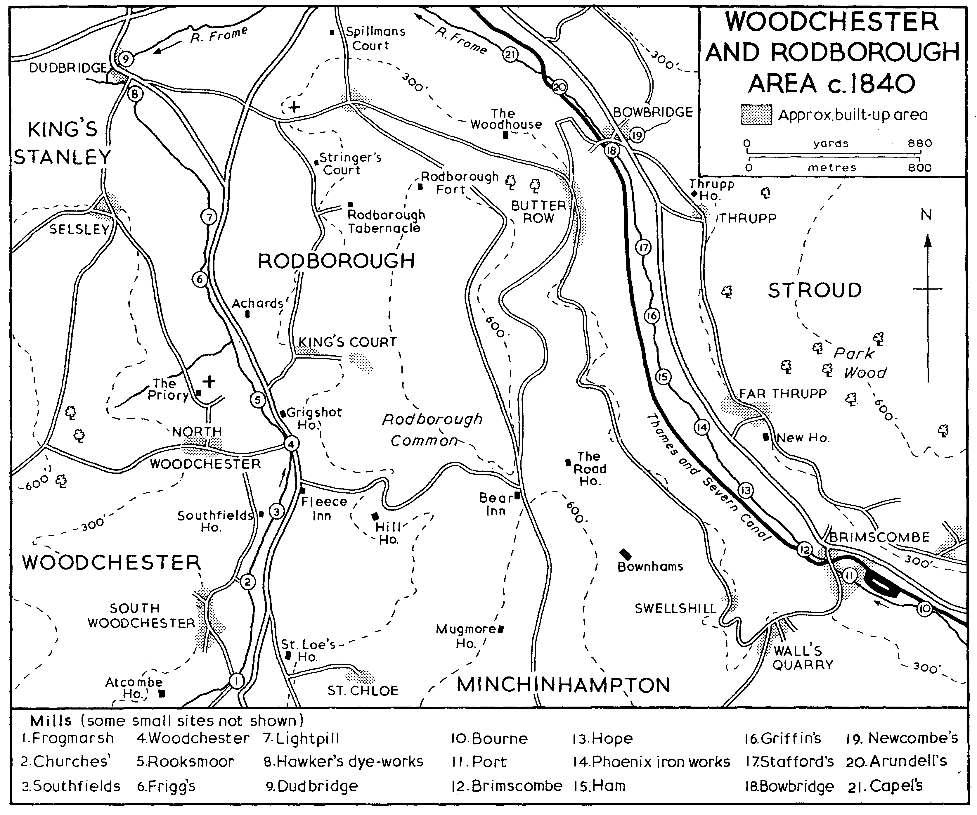
Woodchester And Rodborough Area c. 1840
The modern development of the parish began in the late 19th century with the building of terraced and semi-detached houses in brick along Bath Road (the road from Stroud towards Lightpill), up Rodborough Hill (the old London road) to the Butts, and across the hillside in between the two. That process was considerably advanced by 1882 (fn. 50) and continued apace during the rest of the century and the beginning of the next. By 1936 an estate of council houses had been built on the slopes above Lightpill and another east of Dudbridge, (fn. 51) and council and private building continued in the postwar period on the slopes of the northern part of the parish, stimulated by its inclusion in Stroud U.D. In the 1950s an estate of private houses in Cotswold style was built on land adjoining the south side of the common. (fn. 52)
Twenty-one inhabitants of Rodborough were assessed for the subsidy in 1327, (fn. 53) and 62 for the poll tax in 1381. (fn. 54) There were said to be c. 240 communicants in the parish in 1551 (fn. 55) and 50 households in 1563. (fn. 56) An estimate of 170 families was made in 1650, (fn. 57) of about 750 inhabitants in 160 houses c. 1710, (fn. 58) and of 1,481 inhabitants in 1756. (fn. 59) In 1801 there were 1,658 inhabitants, and the population rose gradually to 2,208 by 1851; it then remained fairly stable until the 1870s when the suburban development of Stroud began, and the population had risen to 2,759 by 1881, 3,378 by 1901, and 3,748 by 1931. (fn. 60) The extension of Stroud U.D. in 1936 took 2,277 people from the parish, (fn. 61) which had 1,414 people in 1951 and 1,485 in 1961. (fn. 62)
Two alehouse-keepers were recorded in the parish in 1664. (fn. 63) During the 18th century the number of inns was comparatively small, apparently due largely to the efforts of the vestry, which threatened action against unlicensed sellers of liquor in 1744 (fn. 64) and in 1788 petitioned the magistrates to reduce the number of alehouses in the parish from four to two. The two they wished to retain were the Bear and the Fleece which stood on the turnpike roads and provided valuable acccommodation. (fn. 65) The Bear had opened by 1751 (fn. 66) on the common beside the Stroud-Cirencester turnpike; it includes a small 17th-century range to which large additions were made c. 1920 to provide hotel accommodation. (fn. 67) The Fleece, opened in 1783 on the new Bath road, was built by Sir George Paul and a group of local gentry with the intention of providing a posting-house between Petty France and Gloucester. (fn. 68) It became a favoured place for meetings and was used in particular for the periodic gatherings of the Gloucestershire clothiers. (fn. 69) The inn, which stood at the junction with the road up to Hill House, (fn. 70) had closed by 1853 and became a residence called Hillgrove House. (fn. 71) Before 1870, however, two other inns both calling themselves the Fleece had opened further along the road, one at Lightpill and the other at Rooksmoor, (fn. 72) and the Rooksmoor one was shortly afterwards distinguished as the Old Fleece. (fn. 73)
The two inns which the vestry sought to close in 1788 were the New Inn, which has not been found recorded later, and the Anchor, (fn. 74) near Wallbridge, (fn. 75) which nevertheless continued as a public house. By 1805 there was also the Woolpack at the south end of Butter Row, which moved to a new site at the central road junction in the hamlet before 1839. (fn. 76) In 1838 the parish had three public houses and 16 beershops (fn. 77) and there were 21 public houses in 1891. (fn. 78) The Bear Hotel, the Fleece at Lightpill, the Old Fleece, the Anchor, and the Woolpack remained open, with four other public houses, in 1973.
Sir Leonard Halliday, lord mayor of London in 1605, was born in Rodborough, (fn. 79) one of a prominent local clothier family. Richard Clutterbuck, who was born in the parish in 1638 and went blind in boyhood, nevertheless became known for his extraordinary abilities as a mechanic and maker of musical instruments. (fn. 80) Other natives of the parish have included John Perry (1670-1732), civil engineer and traveller, (fn. 81) and the architect Benjamin Bucknall (1833-95), who translated the works of his friend, the French architect Viollet-le-Duc. (fn. 82) George III and Queen Charlotte breakfasted with Sir George Paul at Hill House on their visit to the area in 1788. (fn. 83)