A History of the County of Gloucester: Volume 12. Originally published by Boydell & Brewer for Victoria County History, Woodbridge, 2010.
This free content was digitised by double rekeying. All rights reserved.
'Huntley', in A History of the County of Gloucester: Volume 12, ed. A.R.J. Jurica( Woodbridge, 2010), British History Online https://www.british-history.ac.uk/vch/glos/vol12/174-196 [accessed 27 July 2024].
'Huntley', in A History of the County of Gloucester: Volume 12. Edited by A.R.J. Jurica( Woodbridge, 2010), British History Online, accessed July 27, 2024, https://www.british-history.ac.uk/vch/glos/vol12/174-196.
"Huntley". A History of the County of Gloucester: Volume 12. Ed. A.R.J. Jurica(Woodbridge, 2010), , British History Online. Web. 27 July 2024. https://www.british-history.ac.uk/vch/glos/vol12/174-196.
In this section
HUNTLEY
HUNTLEY is a small rural parish lying under May hill 11 km west of Gloucester. The parish, the suffix ley in its name denoting a woodland clearing, (fn. 1) came to cover 1,439 a. (fn. 2) (582 ha) in a compact area with its southern boundary following the Ley brook in the west and a Roman road leading westwards from Gloucester in the east. (fn. 3) North of that road Huntley's eastern boundary was the tract of land known in the 13th century as the wood of Birdwood (fn. 4) and beyond the main road from Gloucester to Rosson-Wye (Herefs.) it passed the place known by the late 18th century as Solomon's Tump. (fn. 5)
LANDSCAPE
From the eastern side of the parish, which is fairly flat and lies at just over 30 m, the land rises gradually before climbing steeply, under May hill, to 200 m on Huntley hill in the west and 170 m on Bright's hill in the north-west. Off the sandstone hills of the west (fn. 6) the land lies on the Keuper Marl and in places gravel terrace. (fn. 7) The south of the parish is drained by a stream flowing off May hill between Huntley and Bright's hills into a ravine known as Deep Filling and continuing south-eastwards past Woodend to join the Ley brook midway along the south boundary. Off the hills the stream was canalized in the mid 19th century and the lower of two ponds created high up between Huntley and Bright's hills at that time was adapted c.1900 as a reservoir to supply water to houses below. (fn. 8) On the north side of the parish a stream flowing eastwards from springs in the centre was known as Butterwall brook in the early 18th century. (fn. 9)
Map 9. Huntley 1840
The wood that according to Domesday Book measured two leagues by one on William son of Baderon's estate was a substantial remnant of ancient woodland that extended westwards into Longhope. (fn. 10) Felling of the wood in Huntley included clearances by Walter of Huntley in the mid 13th century, one alongside the main road to hinder the activities of robbers and another above his court house. (fn. 11) In early modern times a third of Huntley was partly wooded common or waste land. (fn. 12) Part of Huntley Wood common, which ran over Huntley and Bright's hills, was turned into a woodland nursery in the mid 18th century (fn. 13) and the summit of Huntley hill, called Elm Head hill on a map of 1777, (fn. 14) had a crown of one or more fir trees at the end of the century. (fn. 15) Huntley common, on the east side of the parish, was confined to 57 a. mostly on the north side of the Gloucester–Ross road when it was inclosed in the 1850s and Huntley Wood common covered 95 a. at its final inclosure in the 1870s. (fn. 16) The parish had a few small patches of waste land, including part of Gander's green behind Bright's hill, at the time of the Commons Registration Act of 1965. (fn. 17)
In 1841 there was an estimated 148 a. of woodland in the parish, most of it in the north in the Plantation (44 a.) and Rotterins (later Cherry) wood (44 a.) and smaller areas in the north-east and in Broomhill wood in the south-west. (fn. 18) In a redrawing of the boundaries of the northern woodland following exchanges of land in 1857 and 1866 (fn. 19) part of Rotterins wood was felled for farmland and land around the rectory house (Huntley Manor) to its south was imparked. (fn. 20) The park was extended eastwards following a road diversion in 1902 and 1903. (fn. 21) Much of the remaining open land on Bright's and Huntley hills was covered with woodland in the late 19th and early 20th century, most of the new planting there happening after 1905 when woodland accounted for 160 a. in Huntley and included small new woods in the south-east of the parish. (fn. 22) A golf course was created in the east of the parish in 1996. (fn. 23)
ROADS
The main road to Ross-on-Wye and Hereford, a branch off the Roman road from Gloucester, (fn. 24) crosses the middle of the parish from east to west, passing along the south side of Huntley common into the village's main street. West of the village the road formerly ran south-westwards to a fork near Woodend, from where the Monmouth road branched southwards on a curving course through cuttings up to Little London, in Longhope. The Ross road continued south of Woodend and climbed north-westwards through Deep Filling between Huntley and Bright's hills towards Dursley Cross, in Longhope. (fn. 25) In the mid or late 1820s it was diverted north of Woodend to take a more direct line at the start of its ascent west of the village (fn. 26) and a tollhouse opened at the junction near Woodend c.1770 (fn. 27) was replaced by a new building at the new junction with the Monmouth road. (fn. 28) The Ross road had been turnpiked through Huntley in 1726 and the Monmouth road in 1747; (fn. 29) they remained turnpikes until 1880. (fn. 30) In the later 17th century traffic from Gloucester also followed the Roman road along the south side of the parish. That route, which joined the Monmouth road east of Little London, (fn. 31) fell into disuse early in the turnpike era (fn. 32) and it survives mostly as a track or footpath.
Of the lanes leading from the crossroads at the east end of the village, that to the north ran along the side of Huntley common, from which there were early routes north-westwards towards Newent and northeastwards towards Tibberton. (fn. 33) In 1856, on the eve of the common's inclosure, the road was remade as the entrance (North Road) to a new road towards Tibberton. (fn. 34) The lane southwards from the crossroads, the beginning of which was once part of an ancient way to Huntley mill and Blaisdon, (fn. 35) is called Grange Court Lane. It leads to Upper Ley and Lower Ley in Westbury-on-Severn and was straightened in the south-east of Huntley in the late 1880s when it was a way to Grange Court railway station. (fn. 36)
Further west, out of a network of lanes north of the main road, (fn. 37) a road to Newent, described as a highway in 1584 (fn. 38) and making several sharp turns, (fn. 39) was straightened past Northend in 1902 and 1903, the diversion taking it further east away from Huntley Manor. (fn. 40) In the west of the parish Hinders Lane, running southwards from the Ross road at Deep Filling and across the Monmouth road into Blaisdon, and the road running northwards from the Ross road to Gander's green and Glasshouse hill were deemed ancient public rights of way at inclosure in 1872. (fn. 41)
POPULATION
Ten tenant households were recorded on the Huntley estate in 1086 (fn. 42) and seven men and women were assessed for tax in the parish in 1327. (fn. 43) A muster of 1542 named 31 men (fn. 44) and the parish had c.120 communicants in 1551 (fn. 45) and 40 households in 1563. (fn. 46) The number of communicants was put at 150 in 1603 (fn. 47) and the number of families at 50 in 1650. (fn. 48) The population, estimated at 240 c.1710 (fn. 49) and 269 c.1775, (fn. 50) stood at 313 in 1801 and grew to 555 in 1851. It then declined, particularly in the 1870s, before rising from 416 in 1881 to 445 in 1901. Another decline in the early 20th century was checked in the 1920s but the population did not recover fully until the later 20th century, when, as a result of new building in the village, it rose from 498 in 1961 to 1,161 in 1981. After that it dropped back slightly and in 2001 it was 1,023. (fn. 51)
SETTLEMENT
Early farmsteads in Huntley were scattered throughout the parish below the steeper slopes on its west side. The pattern of settlement was also determined by the survival until the later 19th century of extensive commons on both sides of the parish. Thus the parish church stands apart from the village, which grew up later on the fringes of Huntley common.
THE VILLAGE
The village of Huntley stands in the eastern half of the parish. It developed on a simple plan formed by the main Gloucester–Ross road and a line of encroachments to the north along the edge of Huntley common on what has become the west side of North Road. (fn. 52) Just off the main road east of North Road, opposite the junction of Grange Court Lane, is the base of a wayside cross. In the late 16th century a poorhouse stood nearby next to a horse pool and well. (fn. 53) There was also a pound on the edge of the common. (fn. 54) At the crossroads the Red Lion inn facing east to North Road was known as the George in the mid 17th century and had expanded onto the site of another inn, the Crown, by the 1730s. (fn. 55) To its north was a dwelling called the Pale or Paled House in the mid 17th century, (fn. 56) and one of the cottages standing on the edge of the common in the early 18th century survives in Ivydene House. (fn. 57) West of the crossroads Huntley Court, south of the main road, is a substantial house built, apparently in the mid 17th century, in the grounds of the White Hart inn, (fn. 58) where the manor court was held in the mid 18th century; (fn. 59) it was remodelled in the late 18th century as a landowner's residence. (fn. 60)
East of the crossroads a few houses were built south of the main road from the early 19th century and several villas were built further out in the 1860s and 1870s following the inclosure of Huntley common. (fn. 61) Forest Gate (formerly Pool House), at the west end of the village, occupies the large site of a farmhouse that was rebuilt as a residence for the Probyn family in the early 19th century (fn. 62) and became the rectory house in 1866. (fn. 63) To its west, beyond the former line of the Monmouth road, a polygonal toll house erected c.1830 (fn. 64) has an extension added in 1881 when it was a private house. (fn. 65) In the 20th century, and more particularly after the Second World War, the village was enlarged considerably by private and council development. While detached houses and bungalows were built on the main road and on Grange Court Lane, most of the new building took place north of the main road where several fields were covered with housing estates in the 1960s and 1970s. (fn. 66)
OUTLYING SETTLEMENT
The parish church stands off the Ross road 1 km west of the village. The Court House, a dwelling standing to its west (fn. 67) presumably on the site of Walter of Huntley's court house recorded in 1282, (fn. 68) was sold in 1725 to (Sir) Edmund Probyn (fn. 69) and was demolished, presumably by 1752 when the manor court was held elsewhere. (fn. 70) From that time the church stood on its own until the early 1840s (fn. 71) when a school and school house were built to its west. (fn. 72) On the hillside to the north, the 17th-century house of a farmstead called Littletons at the eastern corner of the plantation established in the mid 18th century (fn. 73) became a gamekeeper's cottage. (fn. 74) Lower down to its south-east is a rectangular moated site. (fn. 75) Huntley Manor, (fn. 76) further to the north-east, occupies the site of the early rectory house and dates from a rebuilding for Daniel Capper in 1862 and 1863. (fn. 77) A farmstead established by Capper north of the house close up to Rotterins wood (fn. 78) was known in 1861 as Exhibition Farm (fn. 79) and later, after its acquisition by Edmund Probyn in 1866, as Home Farm. (fn. 80)
42. Huntley church from the south-east: the school is on the left
North of Huntley common a cottage stood among a group of closes called the Billes in the mid 17th century (fn. 81) and a farmstead (Yew Tree Farm) was established nearby following the common's inclosure in 1857. (fn. 82) South of the main road a farmhouse on the parish boundary, known as Coppice Cottage in the 1880s, (fn. 83) dated probably from the 18th century. (fn. 84) The house at Frogland, on the lane leading north-westwards from Huntley common, (fn. 85) was recorded from 1637 (fn. 86) and demolished with its outbuildings in the mid 20th century, the lane having become a cul-de-sac (Frog Lane) by the mid 19th century. (fn. 87) Out on the Newent road at Northend, where there was at least one house in 1509, (fn. 88) the farmhouse occupied by William Hopton in 1673 (fn. 89) has been rebuilt. The cottage at Little Northend, a little higher up to the south, dates from the 17th century (fn. 90) and was known as Pain's Knapp in 1728. (fn. 91) A few houses stand further along the road, one being built on the parish boundary in the early 19th century. A house known as Alma Villa in 1891 (fn. 92) that became the property and residence of the Elton family (fn. 93) was converted as four flats by C.P. Ackers in 1946. (fn. 94)
In the west of the parish the farmstead at Woodend served the largest farm on the manor estate in the early 18th century. (fn. 95) Its house dates from the 17th century and among the outbuildings are substantial ranges provided in the late 1850s by Edmund Probyn. (fn. 96) In 2006, when the farmstead was the centre of a riding school, the house accommodated offices, a house, and rooms for eight students and the outbuildings included an indoor arena completed in 1979. (fn. 97) In 1936 the Huntley Manor estate built two log cabins north of the farmstead by the Ross road, one for offices and the other for an estate cottage. (fn. 98)
On the Monmouth road the Lower House, a copyhold standing east of the stream flowing southeastwards past Woodend, (fn. 99) was demolished in the 18th century. (fn. 100) Further along the road another farmhouse, low down beside the Blaisdon road, was called the Sheepscot in the early 18th century. (fn. 101) Known later as Hinders, (fn. 102) it was rebuilt on a larger scale in the late 19th century. In the same period two new houses were built nearby, on the north side of the Monmouth road. (fn. 103) Further along the road towards Little London, where there was a number of cottages in the late 18th century, (fn. 104) are several 20thcentury houses. (fn. 105)
Scattered settlement had begun on Huntley hill by the early 17th century, when a dwelling on its lower slopes was known as Wood House or Woods, (fn. 106) and had penetrated Smokey bottom, a dell high above Deep Filling, by the early 18th. (fn. 107) By that time there were several dwellings on or near the old Ross road in Deep Filling (fn. 108) and in the late 18th century one at the junction of the road with Hinders Lane was known as Roughcast House. Cottages were also built at and below Gander's green. (fn. 109) More dwellings, mostly small squatter cottages, were erected high up on the commons and in the dells in the early and mid 19th century. (fn. 110) Among the few built there after inclosure in the 1870s the Firs, above Hinders Lane, was for Albert Knight in 1903. (fn. 111) Many of the dwellings have been enlarged, one (Brook Villa) being rebuilt by Edmund Probyn as early as 1857, (fn. 112) and some of the earlier cottages have been abandoned. The Rest House overlooking the Ross road was erected c.1930 by Forest Products Ltd for tea rooms and had a wooden annex, higher up, with ten bedrooms. (fn. 113)
BUILDINGS
The only medieval fabric in Huntley appears in the church tower and as the base of a medieval cross near the junction of the main road and North Road, which serves as the centre of the village. Of the surviving timber-framed houses The Old Rectory, in the village just off North Road, was called Newhall in the mid 19th century (fn. 114) and appears to be the late 16th-century two-storeyed cross wing of a house of high status. It had oriel windows and close studding on its gable ends. (fn. 115) The other, smaller houses were built in the 17th century with their frames infilled with both wattle and daub and brick. They include the former farmhouse of Littletons and the cottage at Little Northend. (fn. 116) Ivydene House, one of the village's timber-framed houses, occupies an early encroachment on the edge of Huntley common. (fn. 117) The outbuildings north of the former farmhouse at Northend include an early 18th-century timberframed barn. (fn. 118)
The first extensive use of brick is found at Huntley Court (fn. 119) and at the two-storeyed Red Lion inn. The latter, built on an L plan in the late 17th or early 18th century when it was known as the George, (fn. 120) was extended by a range of farm buildings and later a western residential block was added.
During the 19th century cottages were enlarged, small stone and brick houses were built randomly on the commons and hills, and the appearance of the main road through the village was transformed by the building of terraced cottages and plain, threebayed red brick villas. The villas, then the smartest small houses in the parish, include a group of three on the south side, (fn. 121) one being larger and L-plan, and a later, more elaborately finished house dated 1888. The Laurels, further east, is one of three villas on a series of regular plots laid out on the north side of the road following the inclosure of Huntley common in 1857. (fn. 122)
Several major building projects were undertaken within the parish in the mid 19th century. In the late 1850s Edmund Probyn created at Woodend the largest and most systematically planned farmstead on his estates in the area. The existing farmhouse, screened on the south in the earlier 19th century by a longer brick range, was remodelled and enlarged and new buildings were placed to the north. The new outbuildings, designed by J. & J. Girdwood, (fn. 123) are of orange-red brick with slate roofs and form an E which opens to the south and has more elaborately treated outer façades. The east–west spine incorporates a hay barn, a two-storeyed granary and feed store that contained probably water-powered machinery for feed preparation, and stables that return as the west wing. The east wing has other stables and a trap house. The central range is a double cowhouse, its wide-span roof of composite timber and iron construction.
The rector Daniel Capper, who in 1862 and 1863 employed S.S. Teulon as the architect for a rebuilding of the church and the rectory house (later Huntley Manor) (fn. 124) as well as for his rebuilding of the village of Hunstanworth (Co. Dur.), (fn. 125) established Home Farm (in 1861 Exhibition Farm) north of the rectory and provided several other new buildings. Those at Home Farm, which Edmund Probyn acquired in 1866, (fn. 126) were arranged with an enclosed central courtyard for the house and an open-sided farmyard to the west. (fn. 127) Henry Miles, Capper's successor in 1866, adapted another house (later Forest Gate) as the rectory house (fn. 128) and rebuilt Capper's school, (fn. 129) which together with the new church formed a picturesque enclave in a parkland setting. (fn. 130)
After 1945 house building was concentrated in the village, where small brick houses and bungalows filled empty sites along the main road and covered the fields to the north. The first council houses, four pairs on North Road, were built in 1952 (fn. 131) and, about the same time, C.P. Ackers, owner of the Huntley Manor estate, built a row of six flat-fronted bungalows with generous gardens on the Tibberton road. (fn. 132) In the 1960s and 1970s small estates of modest houses were laid out, mainly in culs-de-sac, east and west of North Road (fn. 133) and the remaining plots along the main road were filled by individual detached houses and bungalows. Some building also took place on Grange Court Lane. Among the buildings in North Road, which became a focus for social activity, is a plain brick village hall opened in 1970. (fn. 134) C.P. Ackers's conversion of the former Alma Villa on the Newent road as four flats in 1946 was to provide accommodation for men training in forestry at Huntley Manor. (fn. 135)
MANOR AND ESTATES
Following the Norman Conquest Huntley, like neighbouring Longhope, was among the possessions of the lords of Monmouth that passed eventually to the dukes of Lancaster. Among early landholders under Huntley manor was Peter de Somervill, whom the Crown restored to his lands in 1322. (fn. 136) Later property owners included nine freeholders resident c.1710. (fn. 137) The Probyns of Newland, who were investing in land in Huntley by the late 17th century, continued to buy up land there after acquiring the manor in the mid 1720s (fn. 138) and among the few properties to be independent of them in the mid 19th century (fn. 139) was an estate created at Huntley Court in the late 18th century. On the break up of the Probyns' estate in 1884 much of their land was bought with the house called Huntley Manor by the Ackers family, whose descendants sold off parts of that land in the later 20th century.
HUNTLEY MANOR
In 1066 Alwin held an estate of two hides in Huntley from Archbishop Ealdred of York. In 1086 the estate belonged to William son of Baderon, (fn. 140) lord of Monmouth, and in 1144 William's son Baderon of Monmouth confirmed Huntley church to Monmouth priory, founded by Wihanoc of Monmouth in William I's reign. (fn. 141) Huntley descended to John of Monmouth (d. 1248) (fn. 142) and the overlordship of the manor, which owed the service of ½ knight's fee in the early 14th century, (fn. 143) passed with the lordship of Monmouth to the earls, later dukes, of Lancaster. (fn. 144)
Walter of Huntley, who acted for the Crown in 1255 as a seller of wood in the Forest of Dean, (fn. 145) had the manor in 1270 and 1282. (fn. 146) John of Huntley, son and heir of Thomas of Huntley, answered for the ½ knight's fee in 1303 and relinquished his right in the manor, in which Thomas's widow Ela had dower, to Robert de Sapy and his wife Aline by 1313. (fn. 147) Robert, under whom part of the manor was held by his father-in-law Nicholas of Bath, (fn. 148) was granted free warren on the demesne in 1317. (fn. 149) He added to his land in 1315 and 1320 (fn. 150) and, having for a time been deprived of the manor by Thomas of Huntley and his wife Iseult, (fn. 151) died c.1336. (fn. 152) Aline was patron of Huntley church in 1340 (fn. 153) and Thomas of Huntley's son Thomas quitclaimed the manor to Richard Talbot in 1344. (fn. 154)
Richard Talbot (d. 1356) was succeeded in the manor by his son Gilbert. (fn. 155) Following the latter's death in 1387 the manor descended with the Talbots' Longhope manor, (fn. 156) passing with it in the early 17th century to the Grey family, under which Huntley manor was being farmed in 1624 and 1628 by William Purefey and Benjamin Hale. (fn. 157) Sir Edmund Probyn of Newland bought both manors from Henry Grey, duke of Kent, in the mid 1720s (fn. 158) and added land in the adjoining part of Taynton to his estate. (fn. 159) His descendant Edmund Probyn, who became lord of Huntley in 1855, (fn. 160) took up residence in the parish and, having acquired it by exchange in 1866, moved into the new rectory house and renamed it Huntley Manor. (fn. 161) He sold most of the estate in 1884 (fn. 162) but remained lord of the manor until his death in 1890, (fn. 163) after which the manorial rights apparently passed to Wilmot Inglis Jones. (fn. 164)
HUNTLEY MANOR (ACKERS ESTATE)
At the sale of Edmund Probyn's estate in 1884 Huntley Manor was bought with 1,100 a. in Huntley and Taynton, much of it woodland, by Benjamin St John Ackers. (fn. 165) Benjamin, who was MP for West Gloucestershire in 1885, (fn. 166) died in 1915. His son Charles Penrhyn Ackers, (fn. 167) who had bought 700 a. of woodland near by in Newent before the First World War, (fn. 168) enlarged the estate to about 2,000 a. by the purchase of woodland in Blaisdon in the early 1930s. (fn. 169) After his death in 1960 (fn. 170) the estate passed to his daughter Torill. She married Michael Freeman and in 2006, with the sale of the estate's outlying parts and of land in Huntley, including in 1988 Huntley Manor, owned the farmland north of the Ross road with 1,200 a. of woodland in Huntley, Taynton, and Newent. Her sons had sold most of the farmland south of the Ross road. (fn. 171)
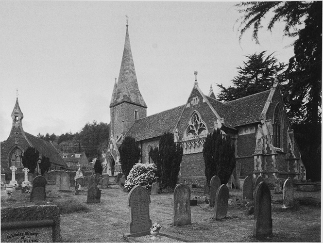
Huntley Manor was Revd Daniel Capper's rectory house built in 1862 and 1863. Designed as a small country house in a North French style by S.S. Teulon, (fn. 172) it had a broken skyline, diapered roof tiles, and iron balconies, finials, and lamps and its walls were of rendered brick. (fn. 173) The plan was rectangular, the rooms linked by a corridor around a small light well in which the main staircase rose on the east side. Very large rooms, including a library, were on the south and west and the main entrance was in a north-western projection that partly screened northern service rooms. The room closest to the front door served as a study. (fn. 174) The interior decoration included Minton tiles in the staircase hall and carved stone chimneypieces with marble jewels, work comparable with that in the contemporary church. Ornamental gardens lay south and west of the house and a large kitchen garden to the northwest. (fn. 175)
43. Huntley Manor in 1884
In the late 19th and early 20th century the house was enlarged, a single-storeyed north hall for servants and billiard and smoking rooms being among the additions. Changes to its interior decoration included the introduction of 18th-century chimneypieces and stained glass designed in 1923 to display the Ackers family coat of arms in the staircase window. In 1964 many of the additions were removed to return the house to its original size. (fn. 176) The house's park was enlarged in the early 20th century (fn. 177) and an east lodge designed by Walter B. Wood was built on the Huntley–Newent road in 1923 and 1924 (fn. 178) and was matched by a second lodge erected to its south in the late 1940s. (fn. 179) Mr Richard Gabriel, owner of the house from 1988, constructed an indoor swimming pool and a helicopter hangar in the grounds and sold the property in 2004 to Professor T. Congdon. (fn. 180)
HUNTLEY COURT
Huntley Court stands south of the main road in the grounds of the former White Hart inn, (fn. 181) which was kept by Giles White in 1657. (fn. 182) The house's compact double-pile plan (fn. 183) with central passage and its symmetrical elevations with crow-stepped gables suggest that it was built in the mid 17th century. There were four heated rooms on each of its two floors; a Mr White was taxed on 8 hearths in Huntley in 1672. (fn. 184) To the west a seven-bayed barn alongside the road has a series of cruck trusses evidently predating the house. (fn. 185) Thomas Blunt, a Mitcheldean surgeon, (fn. 186) bought the house with land in Huntley and Longhope from Edmund Probyn in 1794 (fn. 187) and gave it the name Huntley Court. (fn. 188) He died in 1811 and after the death of his widow Mary in 1828 (fn. 189) his lands passed to his daughter Harriet and the three sons of his late daughter Frances Nayler. (fn. 190) Harriet, who bought out her nephews' interests in Huntley Court in 1844, died in 1859 and the house and its land (25 a.), which she left to her nephew Revd Thomas Nayler, were sold in 1867 to Edmund Probyn. Charlotte Constance Blood bought them from him in 1884 and her son John Neptune Blood sold the house in 1925 to Spencer Shelley (fn. 191) (d. 1941). His son Spencer retained Huntley Court in 1975 (fn. 192) but its ownership changed hands several times in the late 20th and early 21st century. (fn. 193)
After acquiring the house in 1794, Thomas Blunt altered its façade by inserting sash windows, tripartite on the ground floor, and a pedimented doorcase, created a west staircase, and added a stable court and probably the east service wing. Later hoodmoulds were added to the sashes in the main façade and bay windows to the three main reception rooms. (fn. 194) In the mid 19th century the house was occupied by tenants and for a time accommodated a school. (fn. 195) In changes designed for Charlotte Blood by James Dolman in 1885 a new porch and mullioned windows were put on the north front, a porch was constructed to link the bay windows on the south garden front, the service accommodation was enlarged, and there was minor remodelling inside both house and stables. (fn. 196)
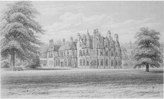
44. Huntley Court: the south front in 1924
ECONOMIC HISTORY
In Huntley's economy woodland management and crafts long played a central role alongside farming and orcharding.
AGRICULTURE
The Middle Ages
In 1086 William son of Baderon's estate in Huntley was worth 30s. compared with 40s. in 1066. In demesne it had one plough and one slave and its tenants were 4 villans and 6 bordars working a total of 3 ploughs. (fn. 197) In 1220 there were six ploughteams in Huntley. (fn. 198) In 1326 the estate that Nicholas of Bath had held from the lord of the manor included 80 a. of arable, 2 a. of meadow, 2 a. of pasture, and 3s. in rents of assize from three free tenants (fn. 199) and in 1337 the manor included 120 a. of arable, 6 a. of meadow, 40 a. of woodland pasture, and 30s. in rents of assize. (fn. 200)
The Early Modern Period
Most of the cultivated land was in old closes and paddocks. A block of closes south-east of the church was known as Church field and closes called Ginger's dole and Red dole in the south and Lady Furlong meadows and Day dole in the north, north-east of Northend, may formerly have been parts of early open fields and common meadows. (fn. 201) By the early 18th century large tracts of common woodland had been mostly cleared of trees and small inclosures, some growing potatoes, had encroached on them. (fn. 202) Huntley common covered 80 a. stretching eastwards from the village to the parish boundary (fn. 203) and Huntley Wood common, where trees had been felled in the early 1630s, (fn. 204) covered 346 a. on Huntley and Bright's hills in the west and was open to extensive common pastures in Longhope. (fn. 205) Piecemeal inclosure and cultivation on the western slopes was facilitated by the pragmatism of the Probyns, lords of the manor from the mid 1720s, in granting leases to cottagers (fn. 206) and a substantial part of Bright's hill was inclosed in the later 18th century to make a timber plantation. (fn. 207)
In 1717 the earl of Kent's manor had 18 tenants holding for lives by copy or lease, with heriots payable, and 2 tenants at will. The principal holding, the farm at Woodend, had 142 a.; seven tenants, including Edmund Probyn, had 39–64 a.; and the rest together with one holding in hand had 30 a. or less. Some of the tenants were among 21 persons owing rent to the manor as freeholders. (fn. 208) By 1763 the farm at Northend had absorbed a holding called Adams (fn. 209) and in 1794 the manor estate had nine farms ranging in size from 200 a. to 15 a. and six smaller holdings. The largest farms were those at Woodend and Northend and of the others two were based on the White Hart and the Red Lion and one included land in Taynton. Some Huntley land was farmed from Upper and Lower Ley, in Westbury-on-Severn. (fn. 210)
Pastoral farming was evidently important at the beginning of the period. A clothier lived in the parish in the early 17th century (fn. 211) and one farmhouse was known as the Sheepscot in the early 18th. (fn. 212) The farmhouse at Northend had a cheese vat in 1673. (fn. 213) In the late 18th century, when the commons were grazed by a few sheep and small cattle, (fn. 214) many of the principal farms had a greater proportion of arable land. (fn. 215) Four fifths of 278 a. reported as being cropped in 1801 were under corn, nearly all wheat of which more than usual had been sown, and very little barley. Scarcely any turnips were grown and potato cultivation included small patches adjoining the commons. (fn. 216) There were orchards for both apples and pears (fn. 217) and tithing customs in 1680 dealt with the collection of fruit tithes. (fn. 218) In the early 18th century Round hill, on the south side of the parish, was known as Honey Pear hill and there were several orchards next to the Court House, by the church. (fn. 219) Many if not all farms had cider mills in the 17th and 18th centuries. (fn. 220)
The Nineteenth and Twentieth Centuries
The land continued to be farmed in holdings that ranged from a few to several hundred acres well into the 20th century. In 1831 six out of ten farmers in Huntley did not employ labour and there were 57 agricultural labourers in the parish. (fn. 221) In 1851, when there was a resident farm bailiff, the principal farmers worked 245 a. (Woodend), 130 a. (Northend), 86 a. (the Red Lion), and 61 a. (Littletons). (fn. 222) Northend and Woodend farms were taken into the home farm of the Huntley Manor estate in the 1880s and 1900s respectively (fn. 223) and the number of agricultural occupiers in Huntley, most tenant farmers, fell from 35 in 1896 to 26 in 1926, when the agricultural workforce also included 31 labourers in regular employment. Apart from the home farm the farms in 1926 comprised one with between 100 and 150 a., two with between 50 and 100 a., five with between 20 and 50 a, and seventeen with less, some much less, than 20 a. (fn. 224) The estate took several more farms in hand in the following years (fn. 225) and its home farm covered more than 500 a. in 1956, when four other farms had between 50 and 100 a., two between 20 and 50 a., and nineteen less than 20 a. (fn. 226) In 1986 there were three farms of over 40 ha (c.100 a.) and six of under 10 ha (c.25 a.) among a total of ten holdings returned for the parish. The farms gave employment to 24 workers, including a manager, and the smaller farms were worked on a part-time basis. (fn. 227)
In 1838 Huntley contained 522 a. of arable and 545 a. of meadow and pasture. Much of the latter was planted with fruit trees and there were numerous small orchards on the sides of Huntley hill. Of the commons, then covering 110 a., (fn. 228) Huntley common was inclosed in 1857 at the expense of Edmund Probyn. He received 54 a., including, by exchange for an old inclosure, 3 a. that were allotted to the rector for the glebe, and two other landowners were given 1 a. each. The Poor's Land charity and 15 people, mostly cottagers, took even smaller allotments, some of only a few perches, and 15 others money payments of £1–£5 for their rights of common. Two pieces of land totalling 8 a. were assigned to the churchwardens and overseers as a recreation ground and as allotments for the labouring poor. (fn. 229) The remnants of Huntley Wood common were finally inclosed in 1872 under an award which also dealt with some old inclosures. Again Edmund Probyn was the main beneficiary, taking 85 a., including 5 a. for his manorial rights. The charity received 5 a. and 21 landholders, including the rector, minute allotments, of which 13, in all 3 a., were sold to Probyn. (fn. 230)
In 1866, when 56 a. was returned as fallow or uncultivated, the farmland again contained almost equal areas of arable and grassland, the area of permanent grass being 454 a., and wheat was the main crop in the rotation, which also included legumes, turnips, and grass leys. (fn. 231) The livestock reported that year were 110 cattle, including 38 dairy cows, 326 sheep, and 136 pigs. (fn. 232) In the later 19th century the dairy herds, a major feature of the principal farms, (fn. 233) increased and the area of arable decreased as more land was put permanently to grass. The livestock reported in 1896, when 872 a. was returned as permanent grassland, included 259 cattle, among them 97 dairy cows, 296 breeding ewes, and 32 breeding sows. Arable farming was restricted to 200–300 a. in the early 20th century and the livestock numbers reported in 1926 were similar to those of 1896. (fn. 234) C.P. Ackers started a herd of black pigs on the Huntley Manor estate's home farm and in the late 1920s he established a flock of sheep on it. (fn. 235) He also maintained a stud of percheron horses, a breed used by the Army, until the 1930s. (fn. 236)
A poultry farm recorded in 1910 was short lived. (fn. 237) Market gardening, one resident's main business by 1881, (fn. 238) was on a small scale and devoted to growing soft fruit, of which 2 a. was reported in 1896 and 6 a. in 1926. In the same period the reported area of orchards increased from 45 a. to 86 a. (fn. 239) Although more plum trees were being planted, (fn. 240) several farmers continued to make large quantities of cider and perry (fn. 241) and after the First World War a factory in Deep Filling, a business founded by Albert Knight in the late 19th century, took apples from local producers and from further afield and delivered cider in barrels and bottles to many parts of the county and to Ross-on-Wye. In the mid 20th century more land was turned to orchards and to blackcurrant and other soft fruit cultivation (fn. 242) and in 1956 272 a. of orchards and 79 a. of soft fruit were returned as opposed to 175 a. of rotated crops and 3 a. of fallow. Dairying and livestock farming remained well represented and 534 a. were returned as permanent grassland and 80 a. as rough grazing. (fn. 243)
More fields were planted with fruit trees and bushes in the 1960s and 1970s and the Huntley Manor estate employed a shepherd into the 1980s, (fn. 244) when sheep farming, fruit farming, and horticulture were each the speciality of one of the three principal farms. The totals returned for the parish in 1988 included, in addition to 100 ha (c.250 a.) of corn, 1,402 sheep and lambs, 95 ha (c.235 a.) of horticultural crops, 68 ha (c.168 a.) of orchards, mostly plums but also apples, pears, and cherries, and 27 ha (c.57 a.) of blackcurrants. (fn. 245) Fruit farming decreased in the late 20th century, many of the trees and bushes grubbed being in the east in the area laid down as a golf course in 1996. (fn. 246)
WOODLAND MANAGEMENT
Huntley contained extensive woodland in 1086. (fn. 247) Trees were felled when the woodland was in the hands of the Crown in the mid 13th century (fn. 248) and Walter of Huntley had made two clearings in his wood by 1282. (fn. 249) The manor included 40 a. of great timber and pasture in 1337. (fn. 250) The rector, whose glebe included half of a coppice acquired by exchange in the mid 17th century, was one of several coppice owners in the parish later that century (fn. 251) and he reserved all his woodland for himself when letting the glebe in the 1720s and 1730s. (fn. 252) In 1608 four charcoal burners, described as colliers, were listed in the parish (fn. 253) and the tithe customs of 1680 and 1698 included bark sold from coppice crops. (fn. 254)
In the early 18th century, when parts of Huntley Wood common including Broom hill in the southwest remained wooded, (fn. 255) the manor's unshared woodland comprised Rotterins (later Cherry) wood in the north and some small coppices in the northeast. Edmund Probyn, the leaseholder of those woods by 1719, (fn. 256) acquired them with the manor in the mid 1720s (fn. 257) and two small nurseries cultivating timber and fruit trees were recorded from 1732. (fn. 258) John Probyn included his Huntley woods in his charcoal concession of 1761 to the agent of the owner of the Flaxley ironworks (fn. 259) and about that time a large part of Huntley Wood common was inclosed for a timber nursery. (fn. 260) In 1794 Edmund Probyn's main woods were Rotterins (40 a.), the Plantation (30 a.) on Bright's hill, and Broomhill (15 a.) in the southwest. (fn. 261) They remained mostly oak plantations until the later 19th century, (fn. 262) when part of Rotterins wood was felled for farmland in the 1860s and 1870s and new areas of woodland, including coniferous plantations, were created on the Huntley Manor estate. (fn. 263) The estate employed up to five gamekeepers at the end of the century. (fn. 264)
C.P. Ackers, who began managing the estate's woodland before the First World War, increased its area considerably and came to run 2,000 a. of commercial woodland and nurseries in and around Huntley. His book Practical British Forestry, published in 1938, described his system of management. He first planted 30 a. of hilly scrub with fir and larch (fn. 265) and by the 1920s had covered much of Huntley hill with trees. (fn. 266) In the 1930s, when most new planting was of spruces, he irrigated and treated with farmyard manure 20 a. for growing willows for cricket bats. Other ventures included businesses to manufacture and sell woodland products (Forest Products Ltd) and to assist landowners in the development of their woodland (Woodland Improvement Ltd). For several years from 1946 Ackers ran a forestry school at Huntley Manor. (fn. 267) Following his death in 1960 some outlying woods were sold and Broomhill wood was bought by Cyril Hart, his former secretary, and in the early 1980s, when its policy was to fell 15 a. of conifers a year, the estate employed seven men in its woods. In 2006 the estate's woodland, 1,200 a. in Huntley, Newent, and Taynton mostly of conifers with some sweet chestnut coppice, supplied the building trade through a single dealer and a nursery in Huntley was run as a separate business. (fn. 268)
WOODLAND CRAFTS AND SAW MILLS
Cask and hoop makers supported at least two families in the late 17th and early 18th century (fn. 269) and a rake maker was recorded in 1771. (fn. 270) In the mid 19th century, when several men were employed as wood fellers and cutters, a smaller number, perhaps two or three, practised crafts such as lath cleaving and hoop and hurdle making. (fn. 271) A besom maker was among the few woodland craftsmen, all among the hill population, in 1881. (fn. 272) Under C.P. Ackers's management of the Huntley Manor woods in the early 20th century the crafts of making wattle hurdles and cleaving chestnut wood for fence pales were revived and Forest Products Ltd, founded in 1927, manufactured fences, gates, and garden furniture at a mill on the Ross road west of the village. (fn. 273) Following Ackers's death that business was sold and, for a few years, the Huntley Manor estate had a saw mill on the Newent road. (fn. 274) Forest Products, which had come to use mostly sawn wood, (fn. 275) opened a shop at its mill in 1987 (fn. 276) and continued to trade in 2006.
OTHER MILLS
Huntley mill, known as 'Stinderforthemilne' in the mid 13th century, stood midway along the parish's south boundary (fn. 277) where the Ley brook is joined by the stream flowing south-eastwards from May hill past Woodend. Part of the manor, it was being leased with Woodend farm in 1717 (fn. 278) and was demolished before the end of the 18th century. (fn. 279)
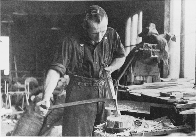
45. Making tent pegs at Forest Products Ltd in 1939
Elsewhere, the pond of a mill at Woodend had been filled and planted as a woodland nursery by 1732. (fn. 280)
OTHER INDUSTRY AND TRADE
A number of sandstone quarries have been opened on the west side of the parish. The largest workings were on the south side of Bright's hill (fn. 281) where quarrying continued in the early 20th century. (fn. 282)
A cinder deposit, identified by field names in use in the early 18th century, (fn. 283) points to ironworking in Roman and perhaps earlier times. In 1608, when some residents derived their livelihood from traffic along the main road, (fn. 284) a smith, a carpenter, a shoemaker, a tailor, and a coverlet weaver were included in a muster roll for Huntley. Joseph White, a leading parishioner at that time, (fn. 285) was a clothier (fn. 286) and weaving, the craft of a parishioner who made his will in 1547, (fn. 287) gave employment to a few men in the late 17th and early 18th century. (fn. 288) William Hopton, the farmer at Northend, was one of several tanners in the early 1670s. (fn. 289) The industry, in which Hopton's son had worked in 1666, was dependent on the bark trade and continued to employ Huntley men in the early 1680s. (fn. 290) Masons and other usual rural craftsmen were resident in the late 17th and early 18th century and there was a distiller in the mid 1680s. (fn. 291)
In 1851 Huntley's master craftsmen included 7 wheelwrights and carpenters, 2 blacksmiths, 2 masons, 3 shoemakers, a plumber and glazier, a tailor, and a hat maker. (fn. 292) Huntley had a saddler in 1863. (fn. 293) A farmer made agricultural implements in 1889 and an engineering business produced incubators and other poultry appliances in 1897. A basket maker was recorded from 1894. (fn. 294) The decline of traditional crafts outside the woodland economy included the closure of a saddlery in the early 1930s (fn. 295) and only a builder and a blacksmith were recorded in a trade directory of 1939. (fn. 296) In 2006 the main employers in Huntley were Forest Products and a plant nursery (fn. 297) and other local businesses included an equestrian centre and an agricultural engineering firm. Nearly half of the working population travelled to Gloucester for employment. (fn. 298)
Huntley's economic benefit from its position on main roads from Gloucester into Herefordshire and south Wales was evident before the turnpike era. It had at least one inn in the late 16th century (fn. 299) and three carriers, one an innkeeper's younger namesake, were recorded in 1608. (fn. 300) A carrier from Monmouth married at Huntley in 1682 (fn. 301) and the parish was a staging post for Herefordshire and Monmouthshire wagons and had several good inns for travellers in the early 18th century. (fn. 302) In the mid 18th century, when the White Hart hosted business meetings, (fn. 303) the Red Lion's keeper supplied grass for cattle and, in 1771, ran weekly carrying services to Gloucester and Ross-on-Wye. (fn. 304) In the mid 19th century, when an ostler lived at the Red Lion, (fn. 305) two Huntley men provided carrying services to Gloucester on market days. (fn. 306)
Two badgers were recorded in Huntley in the 1680s, one being licensed in 1689, and a chandler died in 1702. (fn. 307) Three shopkeepers were resident in 1851 (fn. 308) and a post office was open in 1856. (fn. 309) A machine owner, a castrator, a butcher, and several cattle dealers were among residents supplying agricultural services in 1851. (fn. 310) In the 20th century traffic on the main roads continued to support local businesses. A garage opened in the mid 1920s and Forest Products Ltd erected tea rooms and a lodging house overlooking the Ross road c.1930. Huntley had two garages, a bakery, a butchery, and three other shops, one also the post office, in 1939 (fn. 311) and it retained a post office, a butcher's shop, and two garages in 2004. (fn. 312)
LOCAL GOVERNMENT
MANORIAL GOVERNMENT
The lord of the manor had a court house in 1282 (fn. 313) and the business of the manor court, recorded in the mid 14th century, (fn. 314) apparently included some tenurial matters in Longhope in the late Middle Ages. (fn. 315) The Huntley court had leet jurisdiction and was held by the farmers of the manor in 1624 and 1628. (fn. 316) The Court House by the church was demolished in the 18th century (fn. 317) and the court met at the White Hart in 1752. (fn. 318)
PAROCHIAL GOVERNMENT
In 1576 Huntley's two churchwardens were censured for spending church money on other business. (fn. 319) A parish charity established by that time supported the poor and was later applied solely in poor relief, thus offsetting its cost to the parish; by 1726 it had given up part of a cottage for use as a parish poorhouse. (fn. 320) The amount spent by the parish on administering the poor law, £44 in 1776, rose considerably in the late 18th century and stood at £108 in 1803, when 16 people received regular and 22 occasional help. (fn. 321)
In the early 19th century the cost of relief was usually contained. The number of people receiving regular assistance was 12 in 1815 (fn. 322) and much the same in the mid 1820s when annual expenditure was often just over £130. Occasional payments were made to tramping poor. In the early 1830s the parish employed a salaried overseer and engaged a doctor on several occasions and in 1835, when it paid for accommodation in the Taynton workhouse and in a deaf and dumb institute at Edgbaston (Warws.), expenditure was at its highest (£210). (fn. 323) Huntley became part of the new Westbury-on-Severn poorlaw union later in 1835. (fn. 324)
The parish vestry's business in the later 18th century included annual nominations of men to serve as petty constable. In 1803 a petition from leading inhabitants secured the replacement of the constable on the grounds of age and infirmity. (fn. 325) The vestry remained active in the mid 19th century. In 1844 it chose an assistant overseer by tender and the following year reappointed him as a salaried officer. In 1851 it ordered a complete census of dogs to ensure that all were kept muzzled. In 1852 it required animals trespassing on the commons to be impounded and in 1857, the year Huntley common was inclosed, it set the tariff for keeping animals on the east side of the parish higher than that for animals on the west side. Following that inclosure the vestry oversaw the creation of the recreation ground and in 1868 it entrusted its management to the surveyor of the highways. In 1880 it appointed a salaried surveyor for the former turnpike roads but his immediate successors did not take a salary until 1884. The parish's improvement of the Grange Court road in late 1880s was partly funded by a loan from rector Henry Miles. (fn. 326)
A parish council was first elected in 1894. Its main business included the management of the allotment gardens and the recreation ground with the pound and the pond at its corner. (fn. 327) Stocks recorded from 1828 (fn. 328) stood north of the main road next to the pound (fn. 329) and were moved eastwards to the side of the recreation ground c.1970. (fn. 330)
A police constable lived in Huntley in 1901 (fn. 331) and a cottage there served as a police station after the First World War. (fn. 332)
SOCIAL HISTORY
SOCIAL STRUCTURE
Little is known of the division of landholding in Huntley in the Middle Ages. (fn. 333) In 1327, when Robert de Sapy, the lord of the manor, was assessed there for tax at 6s. 9d., Walter of Hauville was assessed for 8s. and Robert of Hauville for just over 3s. Three other men and one woman, Margery of Hauville, were also assessed, two at just over 2s. and two at just over 1s. (fn. 334) Later lords of the manor, the Talbots, (fn. 335) were nonresident.
In 1522 Huntley's wealthier inhabitants included members of the Bird family, relatives of Richard Bird who in 1470 had owned a holding called Awbery's. (fn. 336) John Bird of Northend, who had a servant, and Thomas Hyett each had goods worth £20. Of some thirty other inhabitants excluding the rector more than half had goods worth £3 or less and for several no valuation was provided. (fn. 337) The Bird family, of which William Bird became a woollen draper in Bristol and by will proved 1590 left part of his wealth to Huntley's poor and the repair of the road to Gloucester, (fn. 338) continued to farm in Huntley in 1608. None of the 42 men then deemed fit for militia service was described as a gentleman. The farming community was represented by 2 yeomen, 5 husbandmen, and 1 bailiff and there were 13 craftsmen and tradesmen as well as 7 labourers and 1 shepherd. Of the 9 servants named, 4 were employed by farmers, 1 by an innkeeper, and 4 by Joseph White, the constable (fn. 339) and a clothier. (fn. 340) The White family later held the White Hart inn (fn. 341) and in 1672 a member was assessed on eight hearths for the site with its new house (Huntley Court). The 45 other parishioners assessed all had fewer hearths, 21 of them only one each. (fn. 342)
The number of cottagers increased in the 18th and early 19th century as squatter development on the commons increased. (fn. 343) About 1710 the population included nine freeholders (fn. 344) and in the later 18th century among the leading tenant farmers were members of the Drinkwater family at Woodend, (fn. 345) of whom Richard kept the Red Lion inn by 1771 (fn. 346) and Ann became overseer of the poor in 1837. (fn. 347) Few members of the gentry were resident, notably William Ellis of Northend, who by will proved 1689 left moneys for rebuilding the parsonage and for the poor, (fn. 348) and Thomas Blunt, a Mitcheldean surgeon who made the house at Huntley Court his residence in the late 18th century. (fn. 349) Most rectors were resident, their house destroyed in the mid 17th century having been rebuilt in the early 18th, and the household of Daniel Capper, rector from 1839, (fn. 350) included half a dozen servants. (fn. 351) In 1817 the lessees of the tithes undertook collectively to provide free carriage for coal for the rector, John Morse. (fn. 352) The Probyns, lords of the manor from the 1720s, were non-resident but after they moved to Longhope in the early 19th century (fn. 353) the heir to the estate lived with his family and servants at Pool House in Huntley. (fn. 354) Edmund Probyn continued to occupy the house after he took over the estate in 1855 (fn. 355) and, following the departure of Daniel Capper in 1866, acquired and moved into the rectory house and renamed it Huntley Manor. (fn. 356) Capper had used part of his personal wealth in the early 1860s to rebuild both the house and the church. (fn. 357)
In the mid 19th century the working population was made up of farmers, many of them working only a few acres, craftsmen, and tradesmen. The principal farmers included the Drinkwater family at Woodend and the Red Lion. (fn. 358) Of the main houses, Huntley Manor retained a large resident staff, including 10 maids, under Benjamin St John Ackers in 1901. (fn. 359) Pool House was remodelled as the rectory house (fn. 360) and Henry Miles (d. 1906), who was a considerable benefactor to the parish, (fn. 361) and his successor George Baker (d. 1934) both employed resident staff. (fn. 362) Huntley Court, occasionally let as a gentleman's residence in the mid 19th century, (fn. 363) was occupied from 1884 by its new owner, Charlotte Constance Blood. (fn. 364) She was a manager of Huntley school alongside Miles and Ackers in 1890 (fn. 365) and with her son J.N. Blood, a barrister, employed three live-in servants in 1901. (fn. 366)
As owner of the Huntley Manor estate from 1915 C.P. Ackers was landlord as well as employer of many parishioners. (fn. 367) The Shelleys, owners of Huntley Court from 1925 with interests in a Sri Lanka tea plantation, (fn. 368) became one of the few other resident gentry families (fn. 369) and in the 1920s and 1930s the population continued to be made up mostly of farmers, craftsmen, and tradesmen. (fn. 370) In the early 1950s Ackers built six bungalows for estate workers (fn. 371) but after his death in 1960 the estate's influence was diluted, in part by the growth of population as houses were built on land that no longer belonged to the estate. (fn. 372) In the early 21st century parts of the enlarged village were a dormitory and nearly half of the working population travelled to Gloucester for employment. (fn. 373) Three of Ackers's six bungalows were occupied by estate workers in 2006. (fn. 374)
CHARITIES FOR THE POOR
By 1577 a cottage north of the main road on the edge of Huntley common and two small pieces of land in Huntley were vested in feoffees for the use of the parish poor and other charitable purposes. In 1656 commissioners set the number of feoffees at six and ordered that £20 given to the poor by Henry Woodward of Gloucester be laid out on land and added to the trust. Woodward's gift was put towards the acquisition of a small piece of land in 1663 and the feoffees' body included the rector from 1726. The trust became known as the Poor's Land charity. (fn. 375) The cottage was let to two tenants before 1683, when it was described as the church house, (fn. 376) and the trust income from rents was distributed among the poor at Christmas in the late 17th century. (fn. 377) In the early 18th century an income of £5 5s. benefited over a score of people and some payments were earmarked for clothes and rents. A prisoner was among recipients in the mid 1720s. (fn. 378) The parish used part of the cottage as a poorhouse (fn. 379) and the charity continued to let the other part after rebuilding it in the early 1760s. In 1770 15 people received cash doles (fn. 380) and in 1828 the charity was shared between up to 60 people regardless of whether or not they were in receipt of parish relief. (fn. 381) Under a Scheme of 1898, when its annual rental was £22 15s. 3d., (fn. 382) the charity gave cash to 45 or more people and from 1920 it had 28 or fewer recipients. (fn. 383) Its property was sold in 1928. (fn. 384)
William Ellis by will proved 1689 left £10 for the poor. (fn. 385) The charity as augmented by a gift of £2 from Lord Kennedy was distributed in bread at Christmas and, following the loss of £5 of the principal, it was vested in Thomas Wintle in 1729 and 7s. a year was given in bread to the recipients of the Poor's Land charity. John Wyman (d. 1721) of Gloucester gave £5 for a distribution of bread on the feast of St John the Evangelist (27 December). The charity, which had 20 recipients in 1727, was dispensed by his daughter Elizabeth Ashley, who in 1752, when wife of Thomas Hartland of Newent, gave £20, 5s. of the income to supplement the charity and the remainder to teach children to read. (fn. 386) Samuel Hawkins (d. 1805) by will gave £200, part of the income for a sermon charity, £1 1s. a year for sixpenny loaves for people attending the sermon service on New Year's Day, and any residue, in default of the kindred of John Belson of Huntley, to two poor householders. (fn. 387)
Among other charitable gifts to the poor were 5s. given by Anthony Grey, Lord Harold, and shared between 17 people at Christmas in 1722 (fn. 388) and a £1 legacy from John Purrock of Highnam that was shared between a similar number early in 1725. (fn. 389) In the later 19th century surplus income from the management of the parish's recreation ground was shared among the poor. (fn. 390)
Hawkins's charity and the other bread charities were distributed together in bread and cash on St Thomas's day (21 December) by 1864, when there were 18 recipients, (fn. 391) and Hawkins's charity paid for the bread until at least 1945. (fn. 392) The charities were amalgamated with the Poor's Land charity in 1975 to form the Huntley Relief in Need charity. After making fixed payments for the New Year's Day sermon, the new charity benefited the parish poor generally and individually. (fn. 393) Its income, though usually less than £100, was £150 in 2006. (fn. 394)
EDUCATION
Thomas Unwin, the rector, taught at least one local boy for several years c.1630. (fn. 395) About 1710 Huntley had a school in which ten children were taught at the expense of the rector, Abraham Morse, (fn. 396) and in 1752 Elizabeth Hartland assigned 15s. a year out of the income of a charitable gift to the teaching of two or more children to read. (fn. 397) There was a school house at Huntley Court in 1811 (fn. 398) and a day school teaching two children with the Hartland gift in 1818 (fn. 399) also taught eight children at their parents' expense in 1833. (fn. 400) Under Daniel Capper, rector from 1839, (fn. 401) a day school was supported in part by pence (fn. 402) and was housed from 1841 in a new building that included separate schoolrooms for the boys and the girls. There was an adjacent house for the master and mistress. That school, which was affiliated to the National Society and was almost entirely funded by Capper, taught 15 boys and 15 girls in 1847 and, having been enlarged in 1855, had an average attendance of 84, including infants, in 1860. (fn. 403) At that time the teachers were a scripture reader and his wife. (fn. 404) In 1863, when new teachers took charge, the school had mixed and infant departments and Capper's curate occasionally taught in it. (fn. 405) Elsewhere, a schoolmaster lived in the south-east of Huntley in 1851 (fn. 406) and Huntley Court accommodated a private girls' school in 1863. (fn. 407)
In 1874 Henry Miles, the rector, enlarged the National school in a substantial rebuilding (fn. 408) completed to designs by J.E. Jones of Gloucester in 1875. (fn. 409) The school was attended by children from May hill (fn. 410) and had average attendances in 1885 of 111 (fn. 411) and in 1904, when it was known as Huntley C. of E. school, of 149. (fn. 412) A private school, open in Huntley in the late 1870s, closed in 1887 (fn. 413) but one of its teachers ran her own school there in 1894 and until at least 1902. (fn. 414) The church school was enlarged in 1912 and 1913 (fn. 415) but the average attendance fell to 96 in 1922. (fn. 416) The older children were transferred to a new school in Abenhall in 1930 and a few children were later awarded scholarships to Newent grammar school. (fn. 417) Huntley school, where the average attendance fell to 57 in 1938, (fn. 418) acquired voluntary aided status after the Second World War (fn. 419) and as Huntley C. of E. Primary school had 85 children on its roll in 2005. (fn. 420) A library and other rooms were added to the main building in 1991 (fn. 421) and a classroom in 1998. (fn. 422) In 1906 the part of the Hartland charity devoted to education was made a separate fund (fn. 423) and in 2004 it had an income of c.£10. (fn. 424)
SOCIAL LIFE
In the later 16th century morris dancers attended local May Day revels presided over by a May lord and Huntley had at least one inn or alehouse. (fn. 425) An unlicensed alehouse was recorded in 1667. (fn. 426) An inn with the sign of the White Hart in 1657 stood on the south side of the main road and was used for business. (fn. 427) The manor court and turnpike trustees met there in the mid 18th century (fn. 428) but the inn had closed by the end of the century, the house in its grounds becoming known as Huntley Court. (fn. 429) The George and the Crown, recorded in 1654 and 1709 respectively, (fn. 430) stood next to each other north of the main road but by the early 1730s the Crown had been demolished and the George had taken the site for its yard and had been renamed the Red Lion. (fn. 431) It was used by friendly societies in the 19th century (fn. 432) and remained open in 2006. In the mid 19th century there were several other inns or beer and cider houses, one called the Mason's Arms being probably by the main road on Huntley common. (fn. 433) The Yew Tree in North Road, a beer house open in 1863, (fn. 434) was for sale in 1919. (fn. 435)
In 1803 a friendly society had 33 members. (fn. 436) In 1825 the parish kept a library for the use of the poor (fn. 437) and in 1885 Revd Henry Miles built a reading room for a working men's club on the south side of the village's main street. (fn. 438) At the inclosure of Huntley common in 1857 the part next to the village was reserved for a recreation ground and a smaller part further east for allotments. (fn. 439) A memorial to the dead of the First World War erected in the recreation area next to the main road took the form of a stone Calvary. (fn. 440) In 1927 a wooden building in North Road became the meeting place of a branch of the Women's Institute (fn. 441) and in 1970 a new village hall opened on the east side of the recreation ground. (fn. 442) The W.I. hut became the headquarters of a scout troop in 1959 and was replaced by a new building in 1975. (fn. 443) The reading room was demolished in the late 1970s. (fn. 444) A cricket ground was established in Grange Court Lane c.1960 (fn. 445) and its pavilion, replacing a temporary building, opened in 1969. (fn. 446)
RELIGIOUS HISTORY
EARLY HISTORY AND THE STATUS OF THE PARISH CHURCH
In the mid 12th century the church at Huntley was a chapel to Longhope church, which the lords of Monmouth had given to Monmouth priory. (fn. 447) Huntley was later a separate rectory, in the gift of John of Huntley in 1304. (fn. 448) The benefice included the May hill district of Taynton to the north from 1935 (fn. 449) and was united with Longhope in 1983. From 2003 the united benefice included Churcham and Bulley. (fn. 450)
PATRONAGE AND ENDOWMENT
The patronage of the rectory passed from John of Huntley to his successors in the manor and in 1336 John de Sapy evidently repeated a presentation made the preceding year by Robert de Sapy. (fn. 451) In 1477, when the lord was a minor, William Hastings, Lord Hastings, acted as patron (fn. 452) and in 1584 Thomas Hooper and John Fowle were patrons for a turn. (fn. 453) The advowson remained with the manor (fn. 454) until the duke of Kent sold it in 1725 or 1726 to Jackman Morse, (fn. 455) vicar of Awre. From Jackman (d. 1765) (fn. 456) it passed through his widow Anne to his son Revd John Morse (fn. 457) (d. 1797). The latter's widow Martha (d. 1826), (fn. 458) together with his daughters Martha, wife of John Morse of Newent, and Hannah, widow of Revd Richard Foley, was patron in 1817. (fn. 459) At the next vacancy, in 1839, Robert Capper of Cheltenham presented his son Daniel, (fn. 460) who was named as patron in 1863. (fn. 461) Henry Miles succeeded Daniel as rector on his own presentation in 1866 (fn. 462) and the patronage was later vested in his brother Philip Miles (d. 1909). In 1914 it belonged to Benjamin St John Ackers of Huntley Manor (fn. 463) and in the mid 1960s it passed from his son's executors to the bishop. (fn. 464)
The rectory was valued at £4 in 1291 (fn. 465) and £7 5s. 10d. in 1535. (fn. 466) Its glebe, made up of the parsonage closes and several detached pieces in 1584, (fn. 467) covered c.38 a. in 1692. (fn. 468) Comprising 45 a. around the rectory house in 1841, (fn. 469) it was enlarged slightly at the inclosure of Huntley common in the late 1850s (fn. 470) and Henry Miles exchanged it with Edmund Probyn in 1866 (fn. 471) for land elsewhere in Huntley and a farm in Westbury-on-Severn. (fn. 472) The farm was sold before the First World War. (fn. 473) All the tithes belonged to the rectory and in the late 17th century the only established moduses were those for gardens and milk. (fn. 474) The tithes, later lessened in value by the substitution of other fixed cash payments, (fn. 475) were commuted in 1841 for a corn rent charge of £250. (fn. 476) The living, which had been valued at £35 in 1650 (fn. 477) and at £60 in 1750 (fn. 478) and had been augmented by Queen Anne's Bounty on gifts from the rector, John Morse, in 1826, (fn. 479) was worth £242 in 1856. (fn. 480)
Rectory Houses, including Huntley Manor and Forest Gate
An early rectory house, part of which was a separate dwelling in 1584, (fn. 481) was destroyed by fire in the mid 17th century and was replaced in 1710 with the help of donations, the largest from the lord of the manor. (fn. 482) Standing some way north of the church, (fn. 483) it was rebuilt on a larger scale in 1862 and 1863 for Daniel Capper. (fn. 484) Following the exchange of 1866 mentioned above, Edmund Probyn made the house his residence and renamed it Huntley Manor (fn. 485) and Henry Miles remodelled and enlarged Pool House, on the main road west of the village, (fn. 486) as the rectory house. Huntley Manor, designed for Capper by S.S. Teulon, is described elsewhere in this account. (fn. 487)
Pool House, which has been renamed Forest Gate, is a plain red brick house with Bath stone dressings built for the Probyns in the early 19th century on a large site. The east front has three gables, the central one marking the entrance hall which is flanked by two receptions rooms. In its conversion as the rectory house Henry Miles employed the architect Thomas Fulljames and the main changes were on the south garden front in 1866. The south-east rooms were enlarged by a canted projection and the southwest portion of the house was replaced by a gabled block containing a staircase hall and a reception room with service accommodation to the west. (fn. 488) A timber porch was added to the east entrance later. The house, which was reduced in size by the demolition of a service wing in the late 1930s, remained the rectory house until 1952. Among its fittings is the bell for the Sunday school once held there. (fn. 489) Part of Miles's new establishment was an extensive collection of outbuildings, (fn. 490) of which a curved brick range incorporating trap house, stabling and pigsties survives.
Since 1952 three other houses have served in succession as the parsonage. (fn. 491)
RELIGIOUS LIFE
The Middle Ages
Huntley church bore its dedication to St John the Baptist by the end of the Middle Ages. (fn. 492) Its late medieval west tower, which is all that remains of the medieval church, (fn. 493) contains a bell dating from the early 15th century. (fn. 494)
Of its rectors, William de Rostele was licensed in 1310 to be non-resident for the purpose of study (fn. 495) and was later a deputy escheator. (fn. 496) In 1323 he was in a group accused of an assault at Gloucester and of forcible entry elsewhere and in 1327 his arrest was ordered for participation in an armed force that went to plunder Berkeley castle and refused to join the Crown's expedition against the Scots. (fn. 497) A new rector was instituted in 1328. (fn. 498) In 1397 both the rector and a chaplain, the latter living in Churcham, were said to lead uncelibate lives, (fn. 499) as was the rector in 1517. Robert Hemming, who was perhaps the rector instructed in 1518 to leave Churcham and serve the cure, was cited several times between 1522 and 1526 for incontinency and remained rector until his death. In 1509 it was revealed that two women had buried an unbaptized, perhaps stillborn, infant in the churchyard and afterwards had exhumed it. In 1517 another woman was accused of sorcery. (fn. 500)
From the Reformation to the Restoration
Richard Taylor, Robert Hemming's successor in 1548, (fn. 501) was unable to recite the Ten Commandments or prove the Apostles' Creed. (fn. 502) He resigned the living in 1556. Henry a Fowle, described as parson in 1557, came from a local family (fn. 503) and had been deprived of Blaisdon rectory in 1554. (fn. 504) Instituted as rector in 1559, (fn. 505) he was censured several times for haunting alehouses and playing cards and tables. Other complaints, some repeated in 1576, were that he studied the scriptures little, failed to preach quarterly sermons and teach the catechism, and admitted to the communion, held only once a year, immoral persons and others unable to say the Lord's Prayer and the Creed. In 1576 it was also reported that the church, while it lacked a psalter and the largest Bible, had a cope and other vestments, that a former churchwarden privately kept two mass books, that May Day revellers were allowed into the church, and that the churchwardens were not spending church money appropriately. (fn. 506) The church has a bell acquired in 1580 and another dated 1616. (fn. 507)
William a Fowle, Henry's son and successor as rector in 1584, (fn. 508) was a conformist and in 1593 was deemed a sufficient scholar but no preacher. (fn. 509) Under him and Thomas Unwin, his successor in 1613, (fn. 510) several parishioners regularly failed to attend church and to take communion. (fn. 511) Unwin, described as a preaching minister in 1650, (fn. 512) remained rector until his death in 1661, (fn. 513) the rectory house being burned down towards the end of his incumbency. (fn. 514)
The Established Church and Nonconformity after the Restoration
Isaac Hague was rector from 1661 until his death in 1688. (fn. 515) At that time the church, described as an entire aisle, had a plain interior with few if any wall monuments. (fn. 516) In 1680 it had a bowl, a flagon, and four bells, (fn. 517) of which the tenor was apparently acquired in 1670. (fn. 518) In 1672 Thomas Smith, the former vicar of Longhope, served a dissenting meeting in Huntley. (fn. 519) One nonconformist was recorded in the parish in 1676 (fn. 520) and 33 parishioners, some if not all dissenters, refused to pay church rates in 1687. (fn. 521)
The rectors between 1688 and 1797 represented three generations of the Morse family. (fn. 522) Abraham Morse, rector 1688–1726, built a new rectory house and lived in it in the early 18th century. (fn. 523) Richard Clark of Painswick was buried in the churchyard in 1717 and commemorated there as 'a zealous assertor of the Protestant Religion and of his Country's Liberties'. (fn. 524) Jackman Morse, rector 1727–65, lived at Awre, where he was vicar, (fn. 525) and employed a curate at Huntley, including on occasions one or other of his sons. (fn. 526) The curate provided one Sunday service, alternately in the morning and afternoon, (fn. 527) and in 1759 the rector led a perambulation of the parish bounds. (fn. 528) John Morse, rector 1765–97, held Blaisdon rectory from 1778 and employed a curate at least in his later years. (fn. 529)
The next three rectors, including Richard Foley (1800–13), held the living for a total of twenty years. John Morse (1817–39), (fn. 530) the last of his family to be rector, was also vicar of Oxenhall from 1824. (fn. 531) At Huntley a Sunday school was taught in his house (fn. 532) and in 1825 the Sunday service, alternating between the morning and the afternoon, was said to attract a congregation of over 100, particularly in the afternoon when the church, with most of its seating free, was filled to capacity. Psalms and hymns were sung to the music of John Nunn. (fn. 533) Under a sermon charity established by Samuel Hawkins (d. 1805) the singers were paid for singing the old 100th psalm on New Year's Day. (fn. 534) In 1825 there were 25 regular communicants and the parish maintained a library. (fn. 535)
Although local nonconformists registered houses in 1798 and 1822, (fn. 536) Huntley was said in 1825 to have no dissenters. (fn. 537) Another Huntley man registered his house in 1838 (fn. 538) and other houses were registered in 1847 and 1850, the latter by the Baptist minister of Longhope. (fn. 539) None of those meetings continued for long.
The Rebuilding of the Parish Church
The parish church, with a chancel, a nave with south porch, and a low west tower, (fn. 540) was described in the late 18th century as very small and having nothing of architectural or antiquarian interest. (fn. 541) Increasing the church's accommodation was the first concern of Daniel Capper, rector 1839–66, (fn. 542) and at the start of his ministry the church was enlarged to hold a north gallery facing the nave and pews were installed in the chancel and benches under an old west gallery and in the belfry at the base of the tower. (fn. 543) From 1844 Capper was assisted by a succession of curates (fn. 544) and in 1851 there were morning and afternoon services with attendances of 100 and 150 respectively. (fn. 545) In 1857 there were 56 regular communicants. (fn. 546) In 1862, after the vestry had accepted Capper's offer to pay for the building's repair and restoration, (fn. 547) the church was stripped of its wall monuments, erected in the later 18th and early 19th century to commemorate among others members of the Morse and Drinkwater families, and was demolished apart from the tower. In its place Capper built a larger church, its chancel as a memorial to his father Robert (d. 1851), and he added a broach spire to the tower. The churchyard was enlarged at the same time. (fn. 548)
The new church, completed in 1863, was designed by S.S. Teulon in the Decorated style and was lavishly furnished. Built of local sandstone with Painswick stone dressings, its chancel is flanked on the north by a chapel and a vestry and on the south by a transeptal organ chamber and it has a nave with a north aisle and south porch. The polychrome interior has biblical texts throughout and carvings by Thomas Earp, notably representations of the Evangelists in medallions on the nave arcade. The glass, by Lavers & Barraud, is richly coloured in the windows of the east end and the bottom of the tower. The other windows display biblical scenes picked out on monochrome glass. The fittings, of which the reredos, pulpit, lectern, and font are in alabaster and marble and by Earp, included a wooden sanctuary arch, an organ, and pendentive lamps, the last (of which those in the nave have been removed) by Francis Skidmore. (fn. 549) The displaced wall monuments were set up in the tower. (fn. 550) The plate comprises a chalice made in 1844 and other pieces made between 1858 and 1862. (fn. 551)
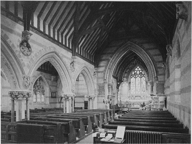
46. Huntley church: the interior looking east
From the Later Nineteenth Century
Henry Miles, rector 1866–1906 (fn. 552) was resident after he had established a new rectory house (fn. 553) and regularly employed a curate. His successor George Baker served in person (fn. 554) and died in 1934. (fn. 555) At the church the tenor bell was recast and a new bell added to the peal in 1878 and the peal was augmented to six in 1884. (fn. 556) A screen was inserted in the tower arch 1908. (fn. 557) The churchyard has two late 19th-century lampposts.
From the 1960s the rectory changed hands more frequently (fn. 558) but even as part of a united benefice Huntley continued to have a resident clergyman in the early 21st century. (fn. 559)