A History of the County of Gloucester: Volume 12. Originally published by Boydell & Brewer for Victoria County History, Woodbridge, 2010.
This free content was digitised by double rekeying. All rights reserved.
'Kempley', in A History of the County of Gloucester: Volume 12, ed. A.R.J. Jurica (Woodbridge, 2010), British History Online https://www.british-history.ac.uk/vch/glos/vol12/196-222 [accessed 30 April 2025].
'Kempley', in A History of the County of Gloucester: Volume 12. Edited by A.R.J. Jurica (Woodbridge, 2010), British History Online, accessed April 30, 2025, https://www.british-history.ac.uk/vch/glos/vol12/196-222.
"Kempley". A History of the County of Gloucester: Volume 12. Ed. A.R.J. Jurica (Woodbridge, 2010), British History Online. Web. 30 April 2025. https://www.british-history.ac.uk/vch/glos/vol12/196-222.
In this section
KEMPLEY
KEMPLEY is a small rural parish on the county boundary midway between Gloucester and Hereford and 9 km SSW of the town of Ledbury (Herefs.). The ancient parish was a slice of land hugging Dymock to its east and extending southwards to Kempley Green and Fishpool, the latter a hamlet in Upton Bishop (Herefs.). (fn. 1) A stretch of the long western boundary against Herefordshire followed the Upton Bishop–Much Marcle road, on which Wiggin's Ash was a landmark in the late 18th century. (fn. 2) Elsewhere the parish was defined by field boundaries and streams and after gaining a small area of Much Marcle (Herefs.) on its side of the Kempley brook below Chibler's hill in the south western corner in the later 19th century (fn. 3) it covered 644 ha (1,593 a.). (fn. 4) In 1965 it was enlarged to 680 ha by the addition from Upton Bishop of settled farmland to the south at Kempley Green and Fishpool. (fn. 5)
Map 10. Kempley 1880
LANDSCAPE
Kempley has rolling and gently undulating countryside save in the south-west where it rises more steeply on Chibler's hill. The Kempley brook flows northwards on the parish's west side before turning eastwards across its north end in a broad valley that is subject to flooding. The land, lying mostly at between 50 and 70 m, rises to 90 m at Kempley Green and to 100 m on Chibler's hill. The soil is a heavy clay mostly on the Old Red Sandstone and with gravelly deposits in the valley of the brook and a tributary joining it from the south below Chibler's hill. (fn. 6)
Although much of Kempley was under the plough at Domesday, more land was brought into cultivation through later woodland clearance. Kempley wood, in the southern end of the parish adjoining the ancient Teds wood in Upton Bishop, (fn. 7) was described as a foreign common wood in 1308. (fn. 8) Piecemeal clearance continued after most of it was inclosed in the mid 16th century (fn. 9) and, with the gradual inclosure of the adjoining waste, (fn. 10) only a remnant of the common of Kempley green was left. (fn. 11) The parish retained very little woodland and only 5 a. of common land in 1839. (fn. 12)
While most of the farmland was in early closes there were several medieval open fields. Their fullest extent is unknown. Orchards, planted locally in arable land, were being established by the mid 14th century and, together with meadows and pastures, accounted for more than half the parish in the 18th century. A park containing oak saplings in 1308 (fn. 13) overlooked the manor house (Kempley Court) from the hillside in the centre of the parish (fn. 14) and was laid down as 30 a. of farmland in the mid 17th century. (fn. 15) To preserve the remaining trees farming leases of Kempley Court in the early 18th century provided an allowance for the tenant to buy coal from the Forest of Dean as his fuel. (fn. 16)
Piecemeal planting begun in the later 19th century has increased the wooded area beyond the 43 a. recorded in 1905. (fn. 17) Most of the new woodland forms a block at the north end of the parish including Stone Redding, (fn. 18) once an ancient wood. (fn. 19) The number of orchards continued to grow in the 19th century but was reduced in the 20th century.
ROADS
Kempley is crossed by lanes and paths used mainly by local traffic. Even the principal lanes were muddy and impassable in winter in the mid 18th century, (fn. 20) as was a new road in 1791. (fn. 21) Only that crossing the north end of the parish from east to west, part of a route between the Gloucester–Ledbury road in Bromesberrow and the Ledbury–Ross-on-Wye road in Much Marcle, was turnpiked, from 1833 (fn. 22) to 1871. (fn. 23) The lane leading southwards past the medieval parish church and up, and along a ridge, to Kempley Green is a way to Newent. The road from Dymock to Ross-on-Wye runs from the east by way of Camomile green (fn. 24) to join the Newent road south of Matthew's Farm and continues its westerly course a short distance further south. At the north end of the parish a hollow lane, part of a highway leading southwards from a place called Broadstone's green, (fn. 25) was abandoned during the construction of Stone House c.1600. (fn. 26) Several lanes in the south, including a way to Ross-on-Wye from the Newent road north of Matthew's Farm, (fn. 27) were closed or abandoned after 1787 (fn. 28) and the course of the Ross road in the far south was diverted near Lower House in 1809. (fn. 29)
POPULATION
According to the Domesday survey there were 17 tenant households on Kempley manor in 1086. (fn. 30) Fifteen persons were assessed for tax in the parish in 1327. (fn. 31) A muster in 1542 named 31 Kempley men (fn. 32) and in 1563 the parish contained 20 households. (fn. 33) The number of communicants was given as c.80 in 1551 (fn. 34) and 60 in 1603. (fn. 35) There were 36 families in 1650 (fn. 36) and the population was estimated at 180 c.1710. (fn. 37) About 1775 the population was given as 257 (fn. 38) but that figure may have been too high, for in 1801 it was recorded as 218. In the first two decades of the 19th century it rose to 301 and, apart from a rise to 342 in 1841, the population remained just over 300 until the late 19th century when it fell to 210 in 1901. A partial revival in its size took place in the mid 20th century and in 1961 it stood at 255 with another 33 people living in those parts of Upton Bishop transferred to Kempley in 1965. The population of the enlarged parish remained the same in 2001. (fn. 39)
SETTLEMENT
Early settlement in Kempley took the form of scattered farmsteads and cottages with the medieval parish church and manor house standing apart in the north end of the parish on opposite sides of the Kempley brook. (fn. 40) The peripheral situation of some dwellings was underlined by the inclusion of the suffix end in their names. The settlement pattern, evident in much of the parish in the mid 14th century and modified by the abandonment of some farmsteads later, (fn. 41) is more intensive in the south where the clearance of woodland continued into the early modern period and a hamlet mostly of squatter dwellings formed on Kempley green. (fn. 42) The hamlet became the southern part of a long village, the northern end of which contains a church built in the early 20th century.
THE VILLAGE
The village straggles along the ridge beside the Newent road in the south of the parish. At its northern end Matthew's Farm belonged as a copyhold on the rectory estate of St Katherine's hospital, Ledbury, to the Edwyn family in the early 14th century (fn. 43) and was occupied by the Matthews or Phipps family by the early 16th. (fn. 44) To the south a cottage called Old Saycell's, a name recorded in 1532, (fn. 45) formed a row of four poorhouses in the early 19th century (fn. 46) and was demolished before the 1880s. (fn. 47) There were a few other early dwellings immediately to the south. One or two small cottages were thrown up on waste land at the junction of the Ross road c.1800 (fn. 48) but the development of the area as the north end of the village dates properly to the 1860s and 1870s when Earl Beauchamp built a schoolroom, a vicarage house (Kempley House), and a temporary church (the village hall) there. (fn. 49) A new church completed south of the junction of the Ross road in 1903 has become the parish church. (fn. 50) Little Adams, built east of the lane to Newent in the early 17th century, (fn. 51) served as a beerhouse in the later 19th century and has been rebuilt, first as a clubroom and later as a house (The Hollies). (fn. 52)
Building had begun higher up on Kempley green by the mid 17th century as part of the settlement of Kempley wood. (fn. 53) In the mid 18th century there were two farmsteads at the north-western end of the green or common (fn. 54) and a two-bayed farmhouse, owned by St Bartholomew's hospital in Gloucester, on its east side; (fn. 55) the last was known later as Folly Farm (Wood's Folly). (fn. 56) More cottages and small houses were built on the common in the later 18th and early 19th century (fn. 57) and the settlement had about 30 dwellings (fn. 58) when, in 1850, a nonconformist chapel was erected there. (fn. 59)
Two council house were built on the lane north of the village in 1934 and another two at Kempley Green in 1939. (fn. 60) Four more council houses were built at the green in 1949 (fn. 61) and another eight, including a row of four, further north at Wantridge, towards the northern end of the village, in 1953 and 1954. (fn. 62) In the later 20th century private building of bungalows and larger houses filled vacant spaces on the green to create a linear residential settlement. (fn. 63)
OUTLYING SETTLEMENT
The farmstead at Powellsend, just off the Dymock road north-east of the village, was formerly known as Powersend, (fn. 64) after a family living in Kempley in the 14th and 15th centuries. (fn. 65) Further along the lane at Camomile green was Upper House (Parsonage Farm), part of the rectory estate, (fn. 66) where some buildings were demolished before the mid 1430s. (fn. 67) The farmhouse was pulled down after its acquisition by Earl Beauchamp in 1869. A stone cottage built near by a few years earlier (fn. 68) was known in 1866 as Camomile cottage. (fn. 69) Further along the lane a farmhouse, on the site of a cottage called the Moors in 1614, (fn. 70) was replaced after it burned down in the 1960s. (fn. 71)
North of the Dymock road Brookland's (formerly Cake's) Farm (fn. 72) belonged to the Brooke family in the mid 17th century. (fn. 73) The Perry House, a farmstead recorded in 1532, stood immediately to the west. (fn. 74) After becoming part of the Brookes' farm (fn. 75) its house was demolished but the farm retained a barn there. (fn. 76) Hillfields Farm, to the north-east, was known until the early 20th century as Print House and sometimes as Turner's Farm. (fn. 77) Presumably a medieval farmstead, (fn. 78) it was taken, together with a farmstead called Lintons, into the manor estate in 1620 (fn. 79) and was sometimes called the Court House in the later 17th century. (fn. 80) Marshall's Farm, on the east side of the parish up against woodland in Dymock, (fn. 81) was on land owned in the Middle Ages by Flaxley abbey (fn. 82) and was possibly named after a family living in Kempley in the early 14th century. (fn. 83) The farmstead, occupied in the late 19th century by the gamekeeper on the Old Grange estate, (fn. 84) was abandoned in the 20th century and the ruins of its small brick house, dating perhaps from the 16th or 17th century, were demolished, apart from a chimney stack, c.1960. (fn. 85)
In the north end of the parish the 12th-century parish church, famed for its wall paintings, stands redundant and virtually solitary on the north bank of the Kempley brook. The only house near it was built for the vicarage in the late 18th century. (fn. 86) Kempley Court, across the brook some way from the church, occupies the site of the manor house used by the Grey family in the early 14th century. (fn. 87) Rebuilt as a gentleman's residence by Thomas Pyndar in the later 17th century, the Court was long a farmhouse. (fn. 88) Two bungalows have been built near by, one in the mid 1960s and the other in the mid 1980s, the latter immediately south of the Court serving as a new farmhouse. (fn. 89)
Friar's Court, some way north of the old church, was established as the main farm on the rectory estate of St Katherine's hospital by the mid 1430s. (fn. 90) Another farmstead belonging to the rectory, known as Woodward's after the family that occupied it from the later 14th century, (fn. 91) stood on the hillside northeast of the church. (fn. 92) Its house was converted as an oast house (fn. 93) soon after the lord of the manor erected a mansion called Stone House right next to it c.1600. (fn. 94) From the later 1720s the site centred on Stone House developed as the principal farmstead in the parish. (fn. 95) Further north, Bridges's Farm, part of the manor estate in the mid 17th century, (fn. 96) stands on the hillside facing north across the Much Marcle road perhaps in the place of Jack's, a farmstead sold to Henry Finch by Thomas Bridges of Sugwas (Herefs.) in 1592. (fn. 97) In the mid 1950s another house was built to the north-east. (fn. 98) North of the road an early farmstead called Tup House (fn. 99) was abandoned, and its buildings demolished, after 1720. (fn. 100)
Saycell's Farm, in the west of the parish, bears the name of a man with property in Kempley in the mid 13th century (fn. 101) and occupies the site of Saycell's Place owned in the early 15th century by the Walwyn family. (fn. 102) Further south a farmstead called Carter's Place in the mid 1430s belonged to the rectory estate. (fn. 103) It had been abandoned by the late 16th century (fn. 104) and its site, west of the Kempley brook, was cleared of buildings. (fn. 105)
In the south-west of the parish French House, on the Ross road below the village, was named presumably after John the French (fl. 1327). (fn. 106) The house, recorded from 1532, (fn. 107) has been replaced by a small brick farmhouse. The farmstead at Lower House, to the west, was known as Jenkins and belonged to the Baynham family in the early 16th century. (fn. 108) In the early 1820s it passed to Ephraim Blewett, a Ross-on-Wye builder who established brickworks nearby. (fn. 109) The farmhouse stands north of the lane opposite outbuildings, to the west of which a new house was built in 2002. Further west a group of cottages near the site of the brickworks includes two built in the early 19th century, one before the course of the Ross road was altered in 1809 and the other by the road from Upton Bishop to Much Marcle. (fn. 110) To the north-west Hill Brook Farm (formerly Bullocksend) stands above the Much Marcle road. (fn. 111) The site of the Bullock family's house called Hillend in 1529, (fn. 112) it was known both as Hill House and Wood's Farm in 1659 when it separated from the manor. (fn. 113)
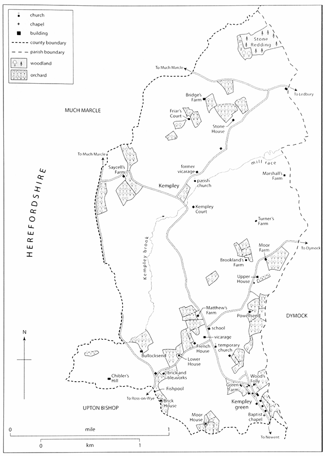
47. Barn at Friar's Court from the south-west
Further south there was at least one cottage beside Teds wood in the mid 16th century, (fn. 114) probably at Fishpool where a new cottage was built within Kempley in the mid 18th century. (fn. 115) Brick House Farm, on the parish boundary to the south-east, was known as the Brick House by 1777. (fn. 116) A cottage to the south-east called the Bull Ring was demolished in the late 18th century. (fn. 117) Moor House, a small farmhouse much further south-east of Fishpool, was recorded from 1532 (fn. 118) and taken into the manor estate in 1624. (fn. 119) To the west on Chibler's hill, a farmstead known as Chievely's belonged to the Baynham family in the early 16th century. (fn. 120) A barn, retained after the house was demolished, became part of the manor estate in 1692 (fn. 121) and stood partly derelict next to other farm buildings in 2003.
BUILDINGS
Most early houses and outbuildings among Kempley's scattered medieval farmsteads, such as a newly rebuilt house at Upper House (Parsonage Farm) in 1581 (fn. 122) and a 'great barn' near Powellsend in 1614, (fn. 123) have not survived. At Friar's Court the northern half of a six-bayed barn, formerly thatched, contains two pairs of late medieval cruck trusses flanking a stone threshing floor. The rest of the barn was added or rebuilt in the 17th century. (fn. 124)
The house at Saycell's Farm (severely damaged by fire in 2006) (fn. 125) was built in the late 16th or early 17th century with a timber frame and three rooms on each of its two storeys. Stone House, a mansion built in the early 17th century, was refurbished later in the century and soon afterwards Kempley Court, the old manor house, was rebuilt as a fashionable residence. (fn. 126) A vicarage house was built in Gothick style at the end of the 18th century. (fn. 127)
A considerable amount of renovation took place on the farms in the late 18th and early 19th century. At Saycell's Farm an outshut with kitchen and dairy was added to the house and, to the south-west, a range incorporating stables and a barn at right angles to the house was partly rebuilt reusing roofs from the earlier buildings. At Lower Farm the house was possibly rebuilt in the 19th century by Ephraim Blewett; (fn. 128) his initials are on a datestone of 1836 on a barn on the opposite side of the lane. (fn. 129)
New building and rebuilding in red brick on the estate of the 6th Earl Beauchamp in the later 19th century has given the building stock a distinctive character. It is seen at a schoolroom (fn. 130) and a new conventional vicarage house (fn. 131) as well as estate farmhouses, outbuildings, and cottages, many of which are marked with datestones bearing the initial 'B'. At Friar's Court, acquired by the earl in 1869, (fn. 132) a new house was built to a standard double-pile, twostoreyed pattern and to its west a range of farm buildings dated 1870 includes stables and cow sheds. At Hill Brook Farm the farmhouse was enlarged on its acquisition in 1871 by the addition of a taller twostoreyed block on its east. (fn. 133) At Saycell's Farm, part of the estate from 1872, (fn. 134) the house and outbuildings were cased in brick and a cider house with granary above was built to fill the space between them. A cowshed added to the outbuildings at the same time. (fn. 135) has been removed. (fn. 136) At Hillfields Farm a new farmhouse was built in 1883 (fn. 137) and the old farmhouse was converted as a store and cider mill. (fn. 138) A new barn was built about the same time and both store and barn were pulled down in the mid 20th century to make way for new outbuildings. (fn. 139) The house at Brick House Farm was rebuilt in 1884. (fn. 140) New labourers' cottages included a plain pair dated 1876 to the south-west of Stone House, where the early 17th-century manor house was rebuilt, with Jacobean gables, as a farmhouse in 1883. (fn. 141)
New building continued on the estate in the early 20th century, the most adventurous architecturally being a church designed for the 7th Earl Beauchamp in Arts and Crafts style. (fn. 142) A new house dated 1908 and outbuildings were provided at Matthew's Farm. (fn. 143) Although the house at Green Farm, at Kempley Green, had also been totally rebuilt, several farmhouses, including Bridge's Farm and Brookland's Farm, retained some timber framing. Among outbuildings erected during that period and removed later was a wood and corrugated iron shed used as a cider bottling plant at Saycell's Farm in 1919. (fn. 144)
New building after the break up of the estate included a number of council houses in the mid 20th century. The housing stock was increased later in the 20th century primarily by new detached houses and bungalows, most of them at Kempley Green where Green Farm became a private house (Kempley Green House). Some farm buildings were converted as dwellings, an outbuilding of the former Upper House being made into a house in the early 21st century.
MANOR AND ESTATES
The manor of Kempley was created by the union of two estates soon after the Norman Conquest and was owned by a succession of prominent families including that of Pyndar, whose name changed in the mid 18th century to Lygon. St Katherine's hospital in Ledbury (Herefs.), which was given Kempley church in the early 13th century, built up a sizeable estate in the parish and Flaxley abbey was among other landowners with possessions there in the Middle Ages. Ownership of the bulk of the land remained divided until the later 19th century when Frederick Lygon, 6th Earl Beauchamp, bought most of the farms not already in his estate. The farms were sold off individually just after the First World War.
KEMPLEY MANOR
In 1086 Roger de Lacy had an estate at Kempley of three hides made up of two manors held in 1066 by Edric and Leuric. (fn. 145) Roger's estates, of which Kempley was almost certainly inherited from his father Walter (d. 1085), (fn. 146) were forfeit by his rebellion against William II in 1095 and were given to his brother Hugh (d. by 1121). They passed to Hugh's nephew Gilbert de Lacy and he was succeeded in turn by his son Hugh (d. 1186) and by Hugh's son Walter. (fn. 147) Walter's lordship over Kempley manor, assessed as ½ knight's fee, (fn. 148) was restored to him in 1215 after a period of banishment. (fn. 149) After his death in 1241 it passed with the barony or honor of Weobley to his granddaughters Margery and Maud and to their descendants, (fn. 150) but from the mid 14th century the manor was sometimes said to be held directly from the Crown. (fn. 151)
In the later 12th century the manor belonged to Emme de St Léger, wife in turn of Hugh de Longchamp (d. by 1194) and Walter de Baskerville. Walter surrendered the estate to her son Geoffrey de Longchamp in 1195 (fn. 152) and Geoffrey's widow Isabel held it in the mid 1230s. (fn. 153) The manor, of which Emery de Cancellis was said in the early 1240s to hold a third from Walter de Baskerville, (fn. 154) passed with the Longchamps' main estate, at Wilton in Bridstow (Herefs.), to Maud, daughter and heiress of Henry de Longchamp, and she and her husband Reynold Grey held it in 1260. (fn. 155)
Reynold, who became Lord Grey of Wilton, (fn. 156) survived Maud and at his death in 1308 the manor passed to his son John. (fn. 157) From John (d. 1323) it descended with the title in the direct line to Henry (fn. 158) (d. 1342), Reynold (fn. 159) (d. 1370), and Henry (d. 1396). Henry settled the manor on the marriage of his younger son Reynold and on the death of Reynold's widow Joan it reverted to Reynold Grey, son of Henry's son and heir Richard (d. 1442). Reynold, who lost the manor temporarily when in 1463 an inquest found incorrectly that John Abrahall (d. 1443) had held it from the Crown, (fn. 160) died in 1494. The manor passed to his son John (d. 1499), Lord Grey, (fn. 161) and in 1502 it was settled on John's widow Elizabeth, who had married Sir Edward Stanley, created Lord Mounteagle in 1514. At Elizabeth's death in 1515 the manor reverted to Thomas, Lord Grey, son of Edmund (d. 1511), Lord Grey. (fn. 162) Thomas (d. 1517), a minor, was succeeded in turn by his brothers Richard (d. 1523) and William, also minors, and Edmund's widow Florence had custody of the manor from 1519. (fn. 163)
William, Lord Grey, was granted livery of his inheritance in 1529 (fn. 164) and he conveyed the manor in 1551 to William Pigott (d. 1553). William's widow Margery (fl. 1579) (fn. 165) was succeeded in it by Anne, the daughter of her son Leonard Pigott. Anne married in turn Samuel Danvers and Henry Finch (fn. 166) and with Henry, described at the turn of the century as of Little Horwood (Bucks.), (fn. 167) occupied a new manor house (Stone House) in Kempley. (fn. 168) Following Henry's death in 1631 and Anne's soon afterwards the manor passed to their son Francis. (fn. 169) Francis, who lived in Rushock (Worcs.), (fn. 170) incurred business debts (fn. 171) and in 1659 he broke up the estate, selling the manor to Thomas Grubham (Grobham) Howe, the third son of John Howe of Little Compton (or Cassey Compton) in Withington. (fn. 172) Thomas, who took up residence in Kempley and acquired a knighthood, died without issue in 1680 and was buried in the family vault in Withington church. He left the manor to his nephew Sir Scrope Howe of Langar (Notts.), (fn. 173) who, to fund a payment to Thomas's widow, sold it in 1682 to Reginald Pyndar of Duffield (Derbs.). (fn. 174)
Reginald Pyndar settled much of the estate in 1686 on the marriage of his son Thomas and Elizabeth Hacket. (fn. 175) Thomas, who rebuilt the old manor house (Kempley Court), (fn. 176) succeeded to the manor on Reginald's death in 1712 (fn. 177) and left it to Elizabeth at his in 1722. From Elizabeth (d. 1759) (fn. 178) it passed to their grandson Reginald Pyndar, who had assumed the surname Lygon on inheriting the Madresfield estate in Worcestershire. (fn. 179) Reginald died in 1788. His only son William Lygon, elevated to the peerage as Lord Beauchamp in 1806, became Earl Beauchamp in 1815 (fn. 180) and after his death in 1816 the manor descended with the earldom and the Madresfield estate. (fn. 181) William's son and heir William (d. 1823) was succeeded in turn by his brothers John (d. 1853), who had taken the surname Pindar, and Henry (d. 1863) and Henry in turn by his sons Henry (d. 1866) and Frederick. Through his purchases of farms and other property (fn. 182) Frederick (d. 1891), the 6th earl, came to own virtually the whole of Kempley. His son and heir William sold the farms and cottages in lots after the First World War (fn. 183) but retained 45 a. of woodland. (fn. 184)
Kempley Court
Following the break up of the 7th earl's estate Kempley Court and its farm (192 a.) were bought by John Houlbrooke. (fn. 185) He sold them in 1943 to W.J. Pugh, whose two grandsons were the owners in 2005. (fn. 186)
Kempley Court occupies the site of the manor house known as the Old Court in the early 16th century when let as a farmhouse and in decay, the upper part of the hall being uncovered in 1533. (fn. 187) Used as a farmhouse in the 17th century, (fn. 188) it was rebuilt by Thomas Pyndar as his residence when he took over the estate in 1686. Pyndar's house, on which his crest appears on a stone plaque dated 1689, (fn. 189) was a compact double-pile house of two storeys and attics, fashionable and superior to most local farmhouses. Although the main, north-western façade and the side walls are built of brick, the rear wall and the internal partitions are timber-framed, the former with brick infill. The roof over the front pile is hipped and covered with stone slates; that over the rear pile is in three gabled sections and tiled. The symmetrical plan contains a central entrance hall with a dog-leg staircase to its south-west. Flanking them are two parlours (the great parlour and withdrawing room reserved by Pyndar for himself in 1701 (fn. 190) ) on the south-western side and a parlour and kitchen on the north-eastern. The interior was probably always plainly finished, the parlours having corner fireplaces and the kitchen an external stack. The pattern is repeated upstairs but with a bedchamber over the entrance hall. The southeastern front had two sash windows per bedchamber and, flanking the central doorcase, narrow lights for the hall. The parlour windows were altered in the early 19th century. (fn. 191) On the north-western front the flat canopy over the main door may replace a shell hood. The narrow walled forecourt has gate-piers (reduced in height) with ball finials.
To the north-east a timber-framed barn with brick nogging and an adjoining two-bayed stable may predate the house. The barn, originally of four bays, was extended by two bays in the early 18th century.
Stone House
Stone House, a mansion on Henry Finch's estate in 1604, stood on land called Stone Acre. (fn. 192) Described later as having pediments and bay windows in early 17th-century style, (fn. 193) it became the manor house (fn. 194) and with 11 hearths by far the largest dwelling in the parish in 1672. (fn. 195) The house became the Gloucestershire seat of the Pyndar family and from the late 1720s was the principal farmhouse on their estate, (fn. 196) the outbuildings making a long range to the north-east. (fn. 197) The 6th Earl Beauchamp, who made changes to the outbuildings in 1871, (fn. 198) had the house demolished and its remains incorporated in the service wing of a red brick farmhouse built in 1883. (fn. 199) The new house was designed in an estate style but with Jacobean shaped gables at each end of the main range.
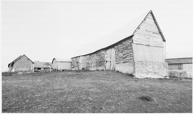
48. Stone House: 17thcentury ceiling
The size and status of the early 17th-century house is indicated by a rubble wall with moulded string course from which a large chimneystack, built of finely dressed stone, projects north-east. That wall and chimney, hidden by an extension to the north-west, form the north-eastern wall of a large room (now subdivided but mainly a kitchen) with a later 17th-century plaster ceiling of six compartments filled with wreaths of fruit and flowers. (fn. 200) The ceiling was probably inserted as part of a refurbishment of the house by Sir Thomas Howe, who in the early 1670s donated timber for alterations to St Mary's church. (fn. 201) Much of the house's carved woodwork, including an overmantel dated 1610 with the initials of Henry and Anne Finch, was moved to Madresfield Court in 1883. (fn. 202)
In 1926 the farmhouse belonged with 160 a. to Charles Stackhouse. (fn. 203) A.D. Evans, who owned it in 1937, sold the house and 312 a. in 1973 to the Watkins family, which owned 620 a. in the farm in 2005. Many of the brick farm buildings erected in the later 19th century have been replaced since 1973. (fn. 204)
OTHER ESTATES
Hill Brook Farm (Bullocksend)
On the break up of the manor estate in 1659 Bullocksend and a lot of land, some of it leased from St Katherine's hospital, were included in a sale to William Bosworth of Leigh (Worcs.). (fn. 205) From William (fl. 1684) the new estate passed to Harry Bosworth (fn. 206) of Hereford (d. 1731) and after the death of Harry's widow Ann in 1738 to his sister Elizabeth Nash of Worcester. After her death in 1741 it was sold to John Worrall of Upton Bishop (Herefs.). (fn. 207) John (d. 1767) left Bullocksend to his grandson John Worrall Rideout (fn. 208) and in 1787 the latter, a Manchester merchant, sold it with 119 a. (178 a. by customary measure) to Daniel Hullett of Much Marcle (Herefs.). (fn. 209) Daniel died in 1808 (fn. 210) and the estate passed from his widow Nancy to his nephew John Hullett the following year. In 1833 John included Bullocksend in a sale of land in Upton Bishop and Much Marcle to John Shore (d. 1834), Lord Teignmouth. The latter's son and heir Charles John Shore (fn. 211) sold Bullocksend to Earl Beauchamp in 1871. (fn. 212) In 1926, following the sale of the outlying parts of the Madresfield estate, (fn. 213) the Joneses, a farming family, owned 125 a. at Bullocksend. (fn. 214) They continued to farm at Bullocksend (Hill Brook Farm) in 2005. (fn. 215) The farmhouse was enlarged on its acquisition by Earl Beauchamp. (fn. 216)
Saycell's Farm
At his death in 1415 Thomas Walwyn of Much Marcle assigned Saycell's Farm, then called Saycell's Place, for the endowment of a chantry in Much Marcle church (fn. 217) but by 1494 the farmstead and its land had been inherited from Richard Walwyn by his son Roger. (fn. 218) In 1533 the farm belonged to Agnes Walwyn (fn. 219) and in 1579 Thomas Walwyn, whose father Sir Richard had given him land in Kempley and Dymock in 1572, (fn. 220) conveyed it to Anthony Kyrle in return for an annuity of £7 10s. (fn. 221) Anthony, later of Ross-on-Wye, died in 1590 leaving the farm to his daughter Sarah. (fn. 222) She married William Scudamore of Ballingham (Herefs.) and in 1601 Thomas Walwyn released them from the payment of the annuity. (fn. 223) William died in 1649 and Sarah in 1659. Their grandson Sir John Scudamore Bt (d. 1684) had the farm and his daughter Sarah, wife in turn of John Holmes (d. 1700) and Philip Monson, (fn. 224) sold it in 1720 to Joseph Cam, a London haberdasher. (fn. 225) From Joseph (d. 1729) the farm descended with Great Netherton in Dymock to Ann Cam (d. 1790) (fn. 226) and at a division between her heirs confirmed in 1808 became the property of John Hill of Stardens, in Newent. (fn. 227) John (d. 1825) left his Kempley land to his brother James (d. 1836) and his nephew Joseph Hill sold the farm (56 a.) to Earl Beauchamp in 1872. (fn. 228) At the sale of the Madresfield estate's Kempley farms Saycell's (87 a.) passed to the tenant R. Down (fn. 229) and in 1922 it was bought by James Price (d. 1949), whose family retained it in 2005. (fn. 230) The farmhouse dated from the late 16th or early 17th century and with its outbuildings underwent alterations in the later 19th century. (fn. 231)
Kempley Rectory
St Katherine's hospital at Ledbury appropriated the rectory after being given Kempley church by Geoffrey de Longchamp c.1230. (fn. 232) Among the church's property was a thicket or hay given to it in the early 13th century. (fn. 233) St Guthlac's priory, successor to a church founded in Hereford by Walter de Lacy (d. 1085), owned some of the tithes (fn. 234) and in 1291, when the rectory was worth £8, its portion was valued at 10s. (fn. 235) John Price acquired the priory and its estates after the Dissolution (fn. 236) and for its tithes in Kempley and Yarkhill (Herefs.) Gregory Price received a pension from the hospital in the late 16th century. (fn. 237)
St Katherine's hospital enlarged its estate by early acquisitions of land (fn. 238) and laymen held all its land on leases by the late 14th century. (fn. 239) The estate remained divided between leaseholders (fn. 240) and the principal holding, Friar's Court with its tithes, was called a manor in 1484 and later. (fn. 241) The dean and chapter of Hereford cathedral, confirmed in 1580 as the hospital's governors, (fn. 242) continued to grant leases of land (fn. 243) and from the early 18th century leases were renewed every seven years on a payment of at least 1¼ year's value. (fn. 244) Later uncertainty about the location of some of the hospital's land prompted the lord of the manor and the dean and chapter in 1810 to identify formally 95 a. held by the former and was resolved in 1819 when the owner of Bullocksend conceded ownership of 26 a. (fn. 245) The dean and chapter sold all the land (271 a.) to Earl Beauchamp in 1869. (fn. 246) Soon after the First World War Friar's Court and other land (225 a.) were acquired from the Madresfield estate by the tenant W.J. Brooke, who thereby became the single largest landowner in Kempley. (fn. 247) His son Mr Kenneth Brooke owned Friar's Court in 2005. (fn. 248)
Other Medieval Monastic and Hospital Estates
Land in Kempley acquired by Flaxley abbey (fn. 249) passed with the estate centred on the abbey's grange (Old Grange) in the adjoining part of Dymock after the Dissolution. (fn. 250) The estate retained c.30 a. at Marshall's Farm on the east side of Kempley until 1920. (fn. 251)
Aconbury priory (Herefs.), founded in the early 13th century by Margery de Lacy, (fn. 252) received early grants of land and rent in Kempley from Geoffrey de Longchamp, Richard son of Robert le Rich of Gloucester, and William de Gamages. (fn. 253) The priory retained the estate until the Dissolution when it provided an annual income of 14s. 6d. in rents. (fn. 254) An estate belonging to Cookhill priory (Worcs.) was first recorded in 1522. (fn. 255) In 1535 it comprised rents worth 3s. (fn. 256) and in 1542 the Crown sold it with the priory and its lands to Nicholas Fortescue. (fn. 257) Another religious house, a commandery, with land in, or perhaps next to, Kempley in the early 1530s has not been identified. (fn. 258)
St Bartholomew's hospital in Gloucester had land in Kempley in the mid 13th century. (fn. 259) The hospital's estate comprising a farmhouse and c.15 a. beside Kempley green in the mid 18th century (fn. 260) was sold in 1884 to Earl Beauchamp (fn. 261) and was owned in 1926 by Joseph Patrick. (fn. 262)
ECONOMIC HISTORY
In common with those of other parishes in the area Kempley's economy was based on mixed farming and orcharding, the latter being established by the later Middle Ages. The principal industrial site was a small brickworks that operated for part of the 19th century.
AGRICULTURE
The Middle Ages
In 1086 the manor, which was worth £5 compared with £4 in 1066 for the two manors it had replaced, had 3 ploughs in demesne and 7 slaves, and the tenants, 10 villans and 7 bordars, worked a total of 12 ploughs. (fn. 263) Arable cultivation was evidently less intensive in 1220 when four ploughteams were recorded at Kempley. (fn. 264)
In the mid 14th century the parish contained several areas of open-field arable. The Rye, probably the largest and named after the principal cereal crop, was on the hillside in the centre of the parish by the Newent road and Whitley was to the west beyond the Kempley brook. Ast field was presumably on the east side of the parish (fn. 265) and Wood field, recorded in the early 16th century, in the south towards Kempley wood. (fn. 266) Woodland clearance gradually brought more land into cultivation (fn. 267) and the planting of orchards, for pears as well as for apples, (fn. 268) evidently began before the mid 14th century when some land was called Perry field. (fn. 269) One farmstead became known as the Perry House. (fn. 270)
In the early 14th century there were two large arable farms, both demesnes in hand, and numerous smaller holdings. On the manor, which included 45 diverse free tenancies in 1308, the demesne comprised 200 a. arable, 10 a. meadow, and 3 a. pasture and ten customary tenants, holding 3 yardlands, owed autumn labour services as well as cash rents. (fn. 271) St Katherine's hospital (fn. 272) had 247½ a. arable, 10 a. meadow, and 3½ a. moor in demesne and kept 2 ploughs as well as 2 horses and 12 oxen in 1316.
Its grange held wheat, oats, and peas and vetches (fn. 273) and in 1322 its bailiff was granted a bushel of wheat a week from Kempley for life in addition to a salary of 10s. (fn. 274) Two tenants held a half and a quarter yardland (30 and 15 a.) for cash rents and labour services. A few other tenants had smaller holdings. The halfyardlander's services included 16 days' harvest work and sending two men to mow a meadow but by 1312 tenants were withholding such services. A few acres of 'forlet' land held for cash rents in 1369 were perhaps among areas more recently cleared for cultivation. In the later 14th century parts of the hospital's demesne were let for cash rents for terms of three lives. The hospital grew crops in Kempley in 1380, (fn. 275) but by 1397 it had leased the whole of the demesne (fn. 276) and in the mid 1430s the estate was made up of nine tenanted holdings, the principal one at Friar's Court. Two of the farms, based on Edwyn's (later Matthew's Farm) and Carter's Place, were merged before 1497 (fn. 277) and the hospital's leases were frequently for terms of up to 99 years by the early 16th century. (fn. 278)
On the manor the demesne was leased to Thomas Walwyn of Much Marcle before 1530, when he was in dispute with Lord Grey, the lord, over the mowing of a meadow. (fn. 279) Aconbury priory had seven tenants on its small estate in the early 14th century (fn. 280) and Cookhill priory three tenants at the Dissolution. (fn. 281)
The Early Modern Period
The manorial demesne was leased to the Bridgeman family of Mitcheldean in the mid 16th century. (fn. 282) The land owned by St Katherine's hospital remained divided between leaseholders and in 1580 contained four farms, one (Friar's Court) of 1½ yardland, another of 1 yardland, and two of ½ yardland each, and several smaller holdings. (fn. 283) Pigs continued to be kept in the parish; in 1554 the manor court ordered all tenants to ring those hogs intended for slaughter and to yoke store swine. (fn. 284)
Following the Restoration Sir Thomas Howe kept part of the manorial demesne in hand with Stone House but from 1674 (fn. 285) the whole of it (437 a.) was divided between several farmers. Most of it was in Stone House and Kempley Court farms, which were held on leases for years; (fn. 286) Thomas Pyndar himself farmed at Kempley Court for several years until 1701. (fn. 287) The manorial estate, which included land held under lease from St Katherine's hospital, (fn. 288) also contained 307 a. divided between 18 tenants holding leases for lives, most of them having under 10 a. and only three (based on Bridge's Farm, Edwyn's, and Print House) more than 70 a. The manor also had five copyhold tenants with holdings ranging from 5 to 37 a. and three tenants at will with considerably smaller holdings. In addition some 19 freeholders had land in the parish. (fn. 289)
Many small farms had been absorbed into larger units by the later 18th century, when there were c.20–25 farms in the parish. (fn. 290) Stone House farm with 260 a. was the largest and in 1787 at least five other farms, including Kempley Court, Matthew's, and Friar's Court, had over 100 a. each. Two of the smallest farms comprising between 10 and 20 a. were on the manorial estate, on which Chibler's hill was farmed from Upton Bishop. Although some owned land, most farmers, especially the principal ones, were tenants. John Brooke's farm, for example, included over 100 a. belonging to the lord of the manor. (fn. 291) Land (26 a.) conceded by the owner of Bullocksend to St Katherine's hospital in 1819 (fn. 292) was later added to Matthew's farm. (fn. 293)
At the beginning of the period open-field land survived among Kempley's small fields and closes. Some holdings had been consolidated (fn. 294) and the piecemeal inclosure of more substantial remnants, such as the Rye and Wood field, continued. (fn. 295) An area of ridge and furrow on the west side of the parish beyond the Kempley brook (fn. 296) had been divided into closes and small fields by the mid 17th century (fn. 297) and the park on the hillside above the Rye was laid down as farmland at that time. (fn. 298) A good proportion of the land was meadow and pasture (fn. 299) and in the 1650s and 1660s several landowners, including Sir Thomas Howe, reserved a right to water such land themselves. (fn. 300)
Orchards, particularly for cider apples, were numerous (fn. 301) and by custom, as recorded in 1705, apple and pear tithes were handed to the vicar at the foot of the trees during the harvest. (fn. 302) In the later 17th century the manorial demesne contained extensive orchards in the area of the former park (fn. 303) and both of its main farms produced great quantities of cider. (fn. 304) The cider made from Red Streak apples was highly regarded (fn. 305) and in 1674 Sir Thomas Howe included a hogshead in the rent of Stone House farm. (fn. 306) Farming leases stipulated the preservation of existing orchards and sometimes new planting of stocks and in 1721 Thomas Pyndar himself undertook to plant 50 fruit trees on Bridge's farm. (fn. 307) By the 18th century many farms had their own cider mills and presses (fn. 308) and, although cereal production, dairying, and sheep farming continued, (fn. 309) cider production became the main business of farming and the watering and draining of farmland was neglected. Together with the meadows and pastures the orchards, planted traditionally on arable land, covered more than half the parish in the 1770s. Even the churchyard was full of apple trees. (fn. 310) From the later 18th century new orchards were increasingly planted on grassland (fn. 311) and a few were created on land newly inclosed from Kempley green. (fn. 312) Hops were grown in various places in the parish (fn. 313) and in the early 17th century an old farmhouse next to Stone House was adapted as an oast house. (fn. 314) Of 275 a. recorded as under crops in 1801 all but a few grew cereals, mostly wheat, and pulses. (fn. 315)
The Nineteenth and Twentieth Centuries
In the mid 19th century, while most of the land was cultivated by tenant farmers, Stone House farm, which with over 200 a. remained the largest unit, was managed by a bailiff employing six labourers in 1851. In addition to the other farms, of which five contained over 100 a., seven men worked smallholdings of between 1 and 5 a. (fn. 316) From 1866, when he became lord of the manor, the 6th Earl Beauchamp (fn. 317) systematically purchased more land for his Madresfield estate (fn. 318) and reorganized many of the farms. In 1875 two of the estate's tenants had farms of over 200 a., six had over 100 a., and three over 50 a. (fn. 319) More land was brought into the estate in the next few years and few farms and smallholdings remained outside it. (fn. 320) Of the 20 agricultural occupiers returned for the whole parish in 1896 only one owned any part of his farm. (fn. 321) In 1901 farming remained the chief source of employment for the majority of parishioners, including several cattlemen, wagoners, and carters, and one farmer's son worked as an engine driver. (fn. 322)
In 1919, when the farms on the Madresfield estate were up for sale, three tenants each worked 200 a. or more and, of the ten others, four had over 100 a. and four under 30 a. (fn. 323) One of the smallest holdings, Moor House farm, was bought by the county council smallholdings' committee. (fn. 324) In 1926, when four of the 22 holdings returned for Kempley had over 150 a., four over 100 a., and six under 20 a., several farms, including most of the largest, were worked by their owners. Altogether the farms employed 27 full-time and 7 casual workers. (fn. 325) Of the 19 farms returned in 1956, one had over 300 a., three over 150 a., two over 100a., and five under 20 a. The agricultural workforce shrank in the later 20th century and only four labourers were hired full-time on some of the 13 farms returned for the parish in 1986. One farm had over 100 ha (c.250 a.) and two over 50 ha (c.125 a.), and of the smaller holdings, several of which were worked by part-time farmers, six had over 30 ha (c.75 a.) and three under 10 ha (c.25 a.). (fn. 326) In the late 20th century larger farming units were created, some landowners renting out land they had once worked themselves, (fn. 327) and in 2005 the largest, Stone House farm, covered 810 ha (2,000 a.). (fn. 328)
In 1840, when 764 a. was devoted to arable crops and 642 a. to grass including leys, the usual threecourse rotation included a fallow and, although a larger number of sheep was kept, the main livestock were milch cows and young beef cattle. (fn. 329) In 1866, when 303 sheep, 210 dairy and beef cattle, and 97 pigs were returned for the parish, (fn. 330) upwards of 400 a. was permanent grassland, over 650 a. was planted with crops, mostly cereals and grass seeds, and 38 a. was fallow. (fn. 331) Dairy herds were sufficiently large to employ a resident dairyman at Kempley Court in 1841 (fn. 332) and a resident dairymaid at Stone House in 1861. (fn. 333) In the later 19th century and the early 20th cereal cultivation decreased and numbers of dairy and beef cattle grew. More land was laid down as permanent pasture (fn. 334) and in the late 1880s the Madresfield estate improved the drainage of a number of fields. (fn. 335) During that period the farm at Upper House was used for breaking in horses. (fn. 336)
Orcharding remained important and in the early 1840s there were several nurseries, one of them on Moor House farm. (fn. 337) The area of orchards, given as 106 a. in 1896, remained constant. (fn. 338) Saycell's Farm, from where Henry Tandy marketed cider and perry commercially, (fn. 339) acquired its own bottling plant (fn. 340) and in the 1920s and 1930s the business of James Price & Sons made cider and perry there for sale locally. (fn. 341) In the later 20th century orcharding declined considerably and in 1986 only 10 ha (c.25 a.) was returned as being commercial orchards, mostly for apples and pears. (fn. 342)
In 1956, when 242 a. was returned as growing corn, 763 a. was described as permanent grassland and 683 a. was used as pasture. The livestock that year included 767 dairy and beef cattle, 482 ewes, and 177 pigs. (fn. 343) Thirty years later, when 360 ha (890 a.) was returned as grassland and at least 164 ha (405 a.) was under corn, three farms were primarily dairy units, another raised beef cattle, another both cattle and sheep, and two specialized in horticulture. (fn. 344) Poultry farming, introduced by 1926, was mainly for chickens and in 1986 2,845 birds were kept for egg production and larger numbers were reared for the table. (fn. 345) While cereal growing and sheep farming have continued, at Kempley Court beef cattle gave way to a dairy herd, introduced in 1994, (fn. 346) and at Stone House livestock farming was abandoned and in 2005 production centred primarily on potatoes and included sugar beet and cereals. (fn. 347) Three dairy farms remained in 2006. (fn. 348)
WOODLAND MANAGEMENT
Oaks were felled in the mid 12th century to construct Kempley's parish church (fn. 349) and one or more foresters were among local inhabitants in the early 13th century. (fn. 350) In the early 14th century Kempley wood, part of an extensive tract of ancient woodland in the south of the parish, was used as a common by people living near by. (fn. 351) Attempts at the time by St Katherine's hospital to extract pannage from its tenants point to the use of local woodland as swine pasture (fn. 352) and the manor court's order of 1554 was probably intended to limit common pasture to pigs intended for slaughter. (fn. 353) In the mid 16th century bark was cropped from felled oaks and the lessee of the manorial demesne, having cut down trees, mostly oaks, in the lord's park and elsewhere, sold timber to people in Dymock, Newent, and Much Marcle. In 1549 Kempley wood was leased to John Abrahall of Eaton Tregoes (Herefs.) and by 1553 he had inclosed 60 a. in it. (fn. 354) That land remained in the hands of a lessee in the early 17th century. (fn. 355)
In the later 16th century timber was dressed if not felled in Kempley for use by St Katherine's hospital. (fn. 356) In the late 1670s timber was felled in Stone Redding in the north end of the parish. (fn. 357) Throughout Kempley woodland was cleared gradually (fn. 358) but after the mid 19th century the process was reversed with piecemeal planting, including conifers, in and around Stone Redding. (fn. 359) The Madresfield estate retained some woodland after selling its farmland in the early 20th century. (fn. 360)
MILL AND FISHPONDS
Saycell had a mill in Kempley in the mid 13th century (fn. 361) and Kempley mill, built on the manorial demesne, (fn. 362) belonged with Saycell's farm to Roger Walwyn in 1494. (fn. 363) Thomas Walwyn retained the mill in 1579 (fn. 364) and the lords of the manor were in possession by 1601. (fn. 365) The mill stood on the Kempley brook south-east of Saycell's Farm and upstream of Kempley Court (fn. 366) and a new ditch dug for the brook in the mid 17th century was presumably intended to improve its water supply. (fn. 367) Reserved as a corn mill in farming leases of Kempley Court in the early 18th century, it was let to a carpenter in 1721 (fn. 368) and was standing, though possibly not in use, in 1787. (fn. 369)
Saycell's farm included two fishponds that Sir John Scudamore reserved for his own use in 1665. (fn. 370)
INDUSTRY AND TRADE
A smith was living in Kempley in 1564 (fn. 371) and a gunsmith there died in 1693. (fn. 372) A smithy operating for many years at the junction of the lane to Kempley green and the Ross road (fn. 373) closed c.1870. (fn. 374) A tailor was recorded in 1589 (fn. 375) and the trades and crafts of the carpenter, shoemaker, cook, and butcher were also practised in the parish in 1608. (fn. 376) A mason lived there in 1707 (fn. 377) as did a wheelwright in 1758. (fn. 378) Textile manufacture has not been recorded in Kempley but in 1567 the manor court expressly forbade the washing of flax and hemp in the Kempley brook. (fn. 379) In 1851 eighteen tradesmen and craftsmen excluding brick makers were counted in the parish. Most of them, including a carrier and a shopkeeper as well as a sawyer and thatcher, lived at or near Kempley Green. (fn. 380) A few men and boys were employed at a brick yard by the Ross road in the south of the parish. (fn. 381) The works, opened in the 1820s or 1830s by the builder Ephraim Blewett, (fn. 382) produced tiles and drain pipes as well as bricks. (fn. 383) They closed in the mid 1890s. (fn. 384)
A blacksmith at Fishpool and a builder at Brookland's Farm in business at the turn of the 20th century both worked on Kempley's new church. (fn. 385) Other parishioners included a hurdle maker (fn. 386) and later a wheelwright (fn. 387) and in 1939 a carpenter. Carrying services linking Kempley with Newent and Gloucester, Ledbury, and Ross-onWye were run from Brick House Farm at Fishpool from the 1870s and continued at a reduced level in the 1930s after a motor haulage business had been established in the parish. Kempley always had at least one shop in the later 19th and early 20th century, residents at Kempley Green including a grocer in 1895, and there was a post office in 1927. Kempley retained three shops, one a bakery and another a tobacconist, in 1939 (fn. 388) but it lacked both a shop and a post office in 2002. An insurance agent lived in the parish in 1903. (fn. 389)
LOCAL GOVERNMENT
MANORIAL GOVERNMENT
In the mid 16th century the manor court, in an important part of its business, handed down punishments for trespasses on the lord's demesne and waste, particularly woodland, for illicit felling of trees, and for poaching of partridges and fish. In 1542 it fined a man for picking apples and pears in the wood and making cider and in 1554 it issued an instruction for the ringing and tethering of pigs. The court also dealt with the maintenance of highways and watercourses. In 1539 three men kept unmarried women in their homes in defiance of an earlier court order. (fn. 390) The court, which was held at Stone House in the 17th century, (fn. 391) was summoned until at least 1746. Encroachments within Kempley wood were a large part of its business in the 1660s and 1670s and the lord of the manor and William Bosworth were both presented in 1666 for not scouring the mill leat. (fn. 392) Deodands were automatically seized for the lord of the manor in the late 17th century. (fn. 393) There is no evidence that gallows were erected in Kempley although the hillside on the eastern side of the parish below the road north of the Kempley brook was known as Gallows hill in the mid 19th century. (fn. 394)
St Katherine's hospital and Aconbury priory held courts at Kempley in the later Middle Ages. The hospital's court, convened in 1307 and until at least 1515, was concerned almost exclusively with tenurial and agrarian matters. In 1325 it heard a case concerning the felling of trees and assarting of land and in 1380 it was notified that four men had fished in the hospital's fishery. (fn. 395) The priory's court, recorded from 1361, dealt invariably with the holdings of its tenants at Kempley and Ketford, although in 1509 presentments were made about excessive pasturing of livestock and the disrepair of a ditch. (fn. 396)
PAROCHIAL GOVERNMENT
Kempley's two churchwardens were first recorded in 1446. (fn. 397) The parishioners' warden came to be chosen by rotation and in 1689, when the post fell to a labourer, the parish in consultation with the lord of the manor, Reginald Pyndar, appointed a deputy in his place. In the late 17th century the churchwardens submitted separate accounts, one being responsible for repairs to the church steeple in 1700, and there was a salaried parish clerk. To prevent mistakes in the selection of its overseers of the poor and petty constable, the parish determined in 1687 that both offices should be served from house to house according to different rotas. In 1692 Reginald Pyndar and other leading inhabitants chose the overseer for Bullocksend, then the possession of an absentee. Later the duties of both offices were occasionally discharged by deputies and in 1749 the constable also served as one of the parish's two surveyors of the highways. (fn. 398) In 1815 a woman's service as overseer was postponed a year because of a 'recent affliction'. (fn. 399)
Following a public meeting convened by the vicar in 1686 the parish indemnified itself against any obligation to provide relief for a family of five living elsewhere. At that time the parish supported one or two residents on a regular basis and made occasional payments for cottage repairs, medical expenses, funerals, and the like. (fn. 400) From the mid 18th century the number of paupers receiving regular help increased and the overseers apprenticed several children to local farmers. The poor, who were put to work spinning flax, numbered eight in 1770. In 1783 they were sent to the Dymock workhouse as a temporary measure and on their return the following year a salaried overseer was employed for a short period. (fn. 401) In the late 1790s the families of two militia men were among those receiving regular help and in 1800 and 1801, when many families sought assistance, the parish bought corn and flour for distribution to the poor. John Forty acted as deputy overseer in the early 19th century and Old Saycell's, a cottage he owned, was adapted as poorhouses. (fn. 402) The parish also acquired a cottage at Kempley Green for the use of the poor. (fn. 403)
Annual expenditure on relief, which had rarely exceeded £10 in the 1730s and 1740s, (fn. 404) rose from £45 in 1776 to £83 in 1803, when 20 people received permanent help, (fn. 405) and to £234 in 1814, when 13 people received permanent and 24 occasional help. The following year, when the comparable numbers were 15 and 19, it was £135 (fn. 406) and in the decade before, in 1835, Kempley joined the Newent poor-law union, (fn. 407) it hovered around that level. (fn. 408)
Works undertaken by Kempley and funded partly by ratepayers in Dymock under an agreement of 1819 presumably improved the chief road between the two parishes. (fn. 409) From 1850 the parish paid a salary for the collection of rates, first to the surveyor of the highways and from 1865 to an assistant overseer of the poor. In 1848 and 1879 ratepayers opposed proposals to use rates for the repair of roads at Kempley Green. (fn. 410) In 1895 the parish meeting was given the powers of a parish council. (fn. 411)
SOCIAL HISTORY
SOCIAL STRUCTURE
In the early 14th century the lords of the manor, the Greys of Wilton, were occasionally resident (fn. 412) and in 1327, when Henry Grey was assessed for tax in Kempley at 10s., two other men were assessed there at 3s. 6d., six others at 2s. or more, three at 1s., and three at 6d. (fn. 413) At that time the principal tenants of St Katherine's hospital disclaimed any duty to perform labour and other customary services and by 1316 one had his sons ordained and his daughters married without licence. (fn. 414) In the late Middle Ages with the Greys as absentees the manor house fell into disrepair (fn. 415) and the farmers were the principal residents. According to a valuation of goods and chattels in 1522, John Matthews (£6 13s. 4d.), whose family held the farmstead called Edwyn's (later Matthew's Farm), (fn. 416) was, with the possible exception of the vicar, the wealthiest inhabitant. He was followed by William Berkeley and Thomas Bullock (£5 each) and among other residents nine had goods valued at £2 or more, eight at £1 or more, and five at less than £1. (fn. 417)
In the early 17th century the lord of the manor was resident and the rest of the community, as represented by thirty-seven men named in 1608, was made up of yeoman farmers, husbandmen, and labourers with a few craftsmen and tradesmen. (fn. 418) Henry Finch, who as lord lived in a new manor house (Stone House), (fn. 419) employed three domestic and four farm servants. William Poole, whose family farmed at Friar's Court by 1567, (fn. 420) employed two servants. In 1676 Henry Poole, whose family remained at Friar's Court until the late 17th century, (fn. 421) was high constable of Botloe hundred. (fn. 422) Following the Restoration, after an absence of several decades, the parish again had a resident lord of the manor in Sir Thomas Howe. (fn. 423) In 1672 he was assessed for tax on 11 hearths, another parishioner on 4, three on 3, four on 2, and thirteen on 1. (fn. 424)
On acquiring the manor in 1682 Reginald Pyndar moved with his family from Derbyshire to Kempley (fn. 425) and in 1689 his son Thomas rebuilt the old manor house (Kempley Court) as his residence. (fn. 426) The Pyndars lived in Kempley until the early 1720s and Elizabeth Pyndar fulfilled the role of lady of the manor from Ludlow (Salop.) in the following decades, (fn. 427) establishing a number of charities for the parish. (fn. 428) In the early 18th century Kempley's population of c.180 included 10 freeholders (fn. 429) and a number of tenant farmers. (fn. 430) In the mid 1740s Elizabeth Pyndar had 18 tenants in Kempley owing rents ranging from £120 to 10s., and on her behalf George Palmer, the farmer at Kempley Court, regularly gave £1 1s. to the poor at Christmas, provided meat and drink for an annual dinner for the tenants, and paid 16s. a year for teaching two children. (fn. 431)
After Elizabeth Pyndar (d. 1759) the lords of the manor lived at Madresfield (Worcs.) (fn. 432) and Kempley, which was rendered inaccessible by poor roads in winter, remained a society dominated by farmers. (fn. 433) Most, if not all, vicars from the late 17th century had been non-resident but following the building of a new vicarage house c.1800 there was a clergyman in the parish. (fn. 434) In 1851 eleven farmers had servants living in and eight of them each employed a domestic servant. (fn. 435) In 1861 four servants lived with Revd A.J. Street and his family at the vicarage house (fn. 436) and in 1901 five farmers and the vicar each had one domestic servant living with them. (fn. 437) The Palmers, who took a lease of Kempley Court in 1722, (fn. 438) farmed there until the 1920s. (fn. 439)
Frederick Lygon (d. 1891), who inherited the manor on becoming 6th Earl Beauchamp in 1866, was active as a landlord in Kempley. He enlarged his estate and provided many new buildings on it. He also built a school, a church, and a vicarage house close to the parish's main centres of population. (fn. 440) In 1872, to celebrate the birth of his son William, he entertained his tenant farmers at Madresfield and organized a distribution of meat, bread, tea, sugar, and cash to his lesser tenants in their parishes. (fn. 441) In 1893, when William (then 7th earl) came of age, a tree was planted at crossroads near St Mary's church to mark the event (fn. 442) and the farmers and cottage tenants attended separate celebrations at Madresfield, (fn. 443) many of them subscribing to the presentation of a loving cup to him. (fn. 444) William Lygon built Kempley a new church, completed in 1903 as a permanent replacement for his father's temporary structure, (fn. 445) and let a field to the parish for use as allotments from 1905. (fn. 446) He relinquished his estate soon after the First World War. (fn. 447)
CHARITIES FOR THE POOR
The parish built up a stock of money from gifts and let it out at interest for the use of the poor. It included £3 given in 1609 by Richard Gwynne, a clothworker, for lending to poor parishioners. The stock, to which John Lewes, the vicar, added 14s. in 1675 and John Wood, a shoemaker, added £1 by will in 1684, (fn. 448) totalled £7 10s. in 1698 (fn. 449) and £8 10s. in 1726. (fn. 450) The interest was shared among the poor, four men and five widows being the recipients at Christmas in 1691, as was money collected at holy communion services and an annual gift by the Pyndar family at Christmas. Up to ten people usually benefited from the collections in the later 17th and early 18th century but there were only three beneficiaries in 1721. (fn. 451)
In 1677 Richard Mayle of Much Marcle (Herefs.) made a gift to provide seven twopenny loaves a year. (fn. 452) The charity, to be distributed on Good Friday, was not recorded after 1705. (fn. 453) Joan Wotton by will proved 1707 gave 10s. a year, charged on Old Saycell's, for the relief of the poor. (fn. 454) In 1744 the charity was shared in cash between nine people and the following year, together with 8s. 6d. interest from the parish stock, between ten people. In 1750 the charity, supplemented by the interest from the stock and a donation of £2 2s. from Elizabeth Pyndar and Reginald Lygon, provided clothing for six people. (fn. 455) In 1753 the parish stock, then £12 10s., was used by John Worrall to buy 2 a. as an endowment for a schoolmistress. The land, charged initially with paying 6s. a year to the poor, (fn. 456) was later devoted solely to helping the poor (fn. 457) and in 1810 the income from it, £1 10s., was distributed with Joan Wotton's charity in bread. In 1818 the two charities and a collection box provided £3 17s. 6d. that was distributed in cash among 23 people, the minimum payment being 2s. In 1825, when the available money included the surplus income from Elizabeth Pyndar's educational charity, £5 13s. 6d. was shared between 25 people. (fn. 458)
The three charities together provided cash payments until at least 1838 and handed out clothes, sheets, and blankets at Christmas by 1854. In the later 1870s they made some cash payments and grants to a local clothing club, but from 1879, when because of severe agricultural depression 18 people received payments totalling £4 1s. 6d., they provided only cash. Payments came to be made on the feast of St Thomas (21 December) and the total sum varied from year to year. In the late 19th century the number of beneficiaries occasionally exceeded 30 and most individual payments were 5s. (fn. 459) In the early years of his incumbency Edward Denny, vicar 1886–98, handed out beef, tea, and sugar on Christmas Eve. (fn. 460) Following the closure of Kempley school in 1919 (fn. 461) Elizabeth Pyndar's educational charity was applied solely to helping needy residents. The tariff of individual payments from the three charities was reduced in 1938 and at one Christmas in the 1960s 26 people received 4s. each, 11 had 10s. each, and one person received £1. (fn. 462) In 1997 the charity originating as the parish stock lapsed and the funds of Joan Wotton's charity were transferred to Elizabeth Pyndar's charity, which under the name of the Kempley charity, had an income of £283 in 2006. (fn. 463)
EDUCATION
In 1605, when Henry Finch employed an unlicensed teacher for his children, the parish clerk was entirely unlearned. (fn. 464) In 1753 John Worrall, following the wishes of his mother Mary, bought 2 a. in Kempley to support a mistress teaching four boys or girls to read, knit, and sew (fn. 465) and in 1755 Elizabeth Pyndar, who had been giving 16s. a year for the education of two children, (fn. 466) donated 4 a. in Much Marcle as an endowment to teach two children to read. (fn. 467) Although the Kempley land was used for other purposes, (fn. 468) in the early 19th century the Much Marcle land provided the salary of the mistress of a day school for which the parish occasionally bought books. The teacher's salary was increased in 1808 from four to five guineas. (fn. 469) From 1818, when it had 12 pupils and was the only school in the parish, (fn. 470) the school was sometimes taught by a local man in collaboration with his wife. (fn. 471) In 1825, when its subjects were reading, sewing, and the catechism, (fn. 472) eighteen Kempley children had a day school education (fn. 473) but in 1833 only six attended the parish's school. (fn. 474) In 1847 the school taught 26 infants on weekdays and Sundays and some older children went to Ann Cam's school in Dymock. (fn. 475) In the 1850s a shoemaker and his wife living at Kempley Green taught the Kempley school. (fn. 476)
In 1866 Earl Beauchamp built a schoolroom some way north of Kempley Green near the centre of the parish. (fn. 477) The school established there in 1867 was managed by Revd A.J. Street as a National school and was funded by the earl, voluntary contributions, pence, and Elizabeth Pyndar's charity. (fn. 478) In 1871 the earl undertook to underwrite the school's cost on condition that local people raised a quarter of it by subscription. (fn. 479) Almost from the outset the managers, led by vicars with High Church views, had difficulty in engaging and retaining acceptable teachers. Attendance was often low and there were several unsuccessful attempts to establish a night school. (fn. 480) In 1904 the day school had an average attendance of 40 in a single mixed department. (fn. 481) An infants' class was later held in a separate room. The school, which changed its name from Kempley National to Kempley Church of England school in 1906, (fn. 482) closed in 1919. (fn. 483)
In the 1920s and 1930s the vicar D. Gethyn-Jones ran a boys' preparatory school in Kempley for sons of local farmers. (fn. 484)
SOCIAL LIFE
Kempley had several beershops or inns in the mid 19th century, including in 1841 the Yew Tree and the Plough at and near Kempley Green. Only that at Little Adams (fn. 485) was open, as the Cross Keys inn, in 1871. (fn. 486)
For long, as in the late 17th century, St. Mary's church was the parishioners' main meeting place. (fn. 487) The schoolroom built in 1866 was used for meetings and in 1874 the schoolmistress helped the vicar to run a club. There was a mothers' meeting in 1890. Among regular events in Kempley was a biennial flower show established by 1886 and enjoying the patronage of Earl Beauchamp. Events for the Golden Jubilee of 1887 were funded by public subscription. A cricket club was formed in 1899. (fn. 488) In 1899 the Cross Keys, which had recently closed, (fn. 489) became the premises of a new club for the men of the parish (fn. 490) and in 1903, on the building of St Edward's church, the nearby temporary church it replaced became the church hall. (fn. 491) The clubhouse closed soon after the First World War (fn. 492) and the church hall, which came to serve as a village hall for Kempley and the neighbourhood, (fn. 493) was rebuilt in 1994. (fn. 494) Two bus shelters were erected in 1949, one on the Ross road and the other at Kempley Green, as memorials to villagers killed during the First and Second World Wars. (fn. 495)
RELIGIOUS HISTORY
EARLY HISTORY AND STATUS OF THE PARISH CHURCH
When Kempley's medieval church was completed in the mid 12th century some tithes there belonged to St Guthlac's priory, successor to the church founded in Hereford by Walter de Lacy (d. 1085). (fn. 496) Geoffrey de Longchamp, lord of the manor and patron of Kempley, (fn. 497) gave its church to St Katherine's hospital, Ledbury, c.1230. The hospital appropriated the rectory after the death of its then incumbent Robert, also styled dean, (fn. 498) who in 1234 paid the hospital an annual rent of a pound of incense specified in Geoffrey's gift, (fn. 499) and the church was served by a chaplain. (fn. 500) In 1447, because of its inefficient use by the hospital, the consistory court sequestered the income and a vicarage was created. (fn. 501)
The benefice was united with Dymock in 1938 (fn. 502) and with Oxenhall in 1955. (fn. 503) In 1975 Kempley was added to the united benefice of Dymock with Donnington (fn. 504) and the parish church was declared redundant and its place taken by a church opened in 1903 in the more populous southern end of the parish. (fn. 505) From 2000 Kempley was part of a benefice embracing nine former ecclesiastical parishes. (fn. 506)
PATRONAGE AND ENDOWMENT
St Katherine's hospital was confirmed in its ownership of the advowson by Reynold and Maud Grey in 1260. (fn. 507) The first presentation to the vicarage, in 1448, was by the bishop (fn. 508) but the patronage remained with the hospital. (fn. 509) The bishop presented by reason of lapse in 1471 and 1479. (fn. 510) Although it was claimed that the lord of the manor had the right to present at every third vacancy, (fn. 511) Margery Pigott was patron for only a turn in 1575 (fn. 512) and exercise of the patronage passed from the hospital's master to its governors, the dean and chapter of Hereford, in the late 16th century. (fn. 513) A move by the dean and chapter to secure the succession to the vicarage led to an intervention by the archbishop of Canterbury in 1606 on the ground of lapse of time. (fn. 514) In the 1640s Francis Finch apparently exercised the patronage (fn. 515) and in 1660, after Charles II had presented to the living by reason of lapse, (fn. 516) the dean and chapter's nomination was rejected. (fn. 517) In 1869 the dean and chapter sold the advowson with the hospital's Kempley lands to the 6th Earl Beauchamp. (fn. 518) The next earl conveyed the patronage to H.L. Roberts of Newent in 1937 (fn. 519) and Revd J.E. Gethyn-Jones acquired Roberts's right c.1970. (fn. 520) Mr R.D. Marcon owned it in 2002. (fn. 521)
The vicarage, which had all the tithes apart from those from Friar's Court, (fn. 522) was valued at £5 4s. 7½d. in 1535, (fn. 523) £40 in 1650, when it was described as a rectory, (fn. 524) and £60 in 1750. (fn. 525) The vicarage tithes were commuted for a corn rent charge of £226 12s. 3d. in 1842 on an agreement which left 143 a. belonging to St Katherine's hospital tithe free and set aside 6 a. of hospital land next to the vicarage house for the use of the vicar. (fn. 526) The living was worth £213 in 1856. (fn. 527)
Vicarage Houses
In 1680 the vicarage house had three bays, one of them newly built, a central stone stack, and three hearths. Its outbuildings included several adjacent sheds and a barn of six bays. (fn. 528) The house, to which another heated bay had been added by 1705, was recorded in 1737 but its location is unknown. (fn. 529)
About 1800 the vicar Robert Squire built a house opposite the medieval churchyard on land belonging to St Katherine's hospital. (fn. 530) Designed as a compact gentleman's residence with Gothick details on a stuccoed three-storeyed and three-bayed façade, it was superseded in the mid 1870s by a new house provided by the 6th Earl Beauchamp in the southern part of the parish (fn. 531) and was extended in the later 20th century in the style of a coach house. The Victorian house, designed in brick in a conventional gabled Gothic manner by the Cheltenham firm of Middleton & Goodman, (fn. 532) was sold in the late 20th century.
RELIGIOUS LIFE
The Middle Ages
Built between c.1120 and 1150, Kempley's medieval church is one of the most complete small 12thcentury churches in England, retaining not only its tunnel-vaulted chancel, chancel arch, and nave with south and west doorways but also much original timberwork and a remarkably complete scheme of painted wall decoration. One of four local churches sharing sculptural details ascribed to a 'Dymock school' of craftsmen, (fn. 533) its lavish construction has been attributed to the Lacy family but may have been by a predecessor of Emme de St Léger, lady of the manor later in the century, (fn. 534) The south and west doorways are flanked by attached columns with capitals and have tympana, that over the south door decorated with a carving of the Tree of Life. (fn. 535) The nave roof is the earliest to survive in England and the west door is original. (fn. 536) The east window seems to have been enlarged shortly after the church was built and the chancel decoration representing the vision of the Apocalypse and Christ in Majesty described in the Book of Revelation remained untouched until the Reformation. (fn. 537) The paintings on the nave walls were altered in the Middle Ages to display at various times a Doom, imagery related to particular saints, and the Wheel of Life. (fn. 538) The fabric was altered by the addition of a short west tower without an external entrance in the later 13th century and the construction of a timber-framed south porch and the enlargement of a nave window in the 14th century.
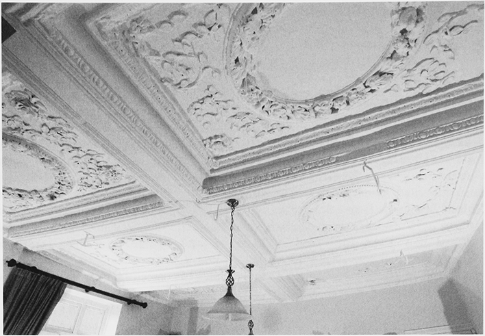
49. St Mary's church: the south doorway with original ironwork on the door
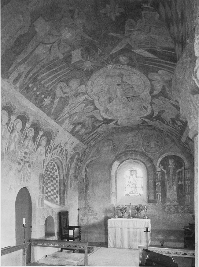
50. St Mary's Church: the chancel
In the early 13th century, when the daughters of a forester gave it a thicket in return for an annual mass, the church had a dedication to St Leonard. (fn. 539) The date of its dedication to St Mary is unknown but in the late 14th century St Katherine's hospital withheld its annual gift of wax to the light of St Leonard (fn. 540) and one of two early 15th-century bells in the church bore an inscription invoking the protection of the Virgin. (fn. 541) The church also retains a chest made from an oak felled in the later 15th or early 16th century. (fn. 542)
Following its appropriation in the 13th century the church was presumably served by chaplains from the hospital at Ledbury. (fn. 543) Much later it was claimed that the lords of the manor gave the hospital its land in Kempley to support two beadsmen and one other serving at the lord's request as well as a priest celebrating mass on three days a week. (fn. 544) The parishioners were without ready access to the chaplain in the late 14th century as there was no manse near the church. (fn. 545) Among the parishioners cited before the court in 1446 were seven men said to have withheld ecclesiastical rights and a woman accused of adultery with the chaplain. Most of the vicars serving the church from 1448 were in place for less than ten years. (fn. 546) George Blundell (1515–27) was succeeded by Thomas Blundell, (fn. 547) the hospital's previous master. He resigned the living after two years with a pension (fn. 548) charged in 1531 on his successor John Cam. (fn. 549)
From the Reformation to the Restoration
At or soon after the Reformation the paintings in the church were covered with whitewash and texts were later painted on the nave walls. (fn. 550) In 1551 there were c.80 communicants and John Cam and his curate were equally ignorant, both unable to recite the Ten Commandments. (fn. 551) In 1552, during a vacancy in the vicarage, Edward Baskerville, the hospital's master, had the church key removed so that services could not take place there. William Scull, the next vicar, (fn. 552) was non-resident and employed a curate. (fn. 553) Humphrey Craddock (or Taylor), vicar from 1575, (fn. 554) was not a preacher but, although not a graduate in 1584, was considered a sufficient scholar in 1593. (fn. 555) He died in 1605 but his designated successor, his son John, (fn. 556) was not instituted until 1607 and only after the resignation of Richard Atkins, to whom the archbishop had given the living because of the delay. (fn. 557)
The church was reported in 1576 incorrectly as lacking a table of the Commandments and a book of homilies. (fn. 558) Responsibility for maintaining the chancel belonged to the lessees of Friar's Court, including several generations of the Poole family. (fn. 559) Two parishioners were described as recusant in 1577 (fn. 560) and several people, including the landowner Richard Kyrle, failed to attend church and take communion in the late 16th century. (fn. 561) Although it was claimed in 1603 that there were no recusants in the parish, (fn. 562) at least two parishioners absented themselves from church in 1605 (fn. 563) and a larger number, at least eight in 1639, regularly failed to take communion in the 1620s and 1630s (fn. 564) In the late 1640s the landowner William Kyrle was included in a list of Roman Catholics in the county. (fn. 565) A memorial to Henry and Anne Finch, lord and lady of the manor, was erected in the chancel by their son in 1633 (fn. 566) and the parish retains a paten acquired the following year. (fn. 567) John Craddock, who succeeded his father John as vicar in the 1640s, (fn. 568) was a preaching minister (fn. 569) and remained in post until his death. (fn. 570) Paul Frewen, a leading member of a Baptist church in Dymock, became vicar in 1658 and was ejected at the Restoration. (fn. 571)
The Established Church and Nonconformity after the Restoration
John Lewes, vicar 1666–93, was resident. (fn. 572) His successor Peter Senhouse, a vicar choral in Hereford cathedral, was also vicar of Linton (Herefs.) from 1703 and resigned his cathedral post in 1705. (fn. 573) Religious dissent during that period was limited, three men being described in 1669 as schismatics (fn. 574) and only three nonconformists being reported among 100 parishioners in 1676, (fn. 575) and may have died out entirely by the mid 18th century. (fn. 576)
Following the Restoration the church nave was given new windows, one on the south side lighting the pulpit next to the chancel arch, and new pews and a ceiling and west gallery were inserted in it. In the latter work, undertaken in the early 1670s largely at the cost of Sir Thomas Howe who supplied much if not all of the timber, (fn. 577) the ceiling was supported on beams, brackets, and pilasters that appear to have been designed to stand on panelling. (fn. 578) Among acquisitions for the church were a baluster font, (fn. 579) a bell cast in 1680, (fn. 580) and a silver tazza by gift from Bridget Morgan in 1705. (fn. 581) The lords of the manor worshipped in a large pew in the north side of the nave in front of the chancel arch; (fn. 582) in the 18th century a memorial to the Pyndar family was placed on the wall before the pew. (fn. 583) The Poole family continued to be responsible for the chancel's fabric. (fn. 584) The vicar received a rent charge of 5s. for church purposes (fn. 585) but the payment was discontinued in 1682 because the land from which it was owed could not be identified. (fn. 586) In 1735 Elizabeth Pyndar assigned a rent charge of £3 to support a communion service on the second Sunday of each month, £2 2s. for the vicar or curate conducting the service and the rest for bread and wine. (fn. 587)
Peter Senhouse, who retained the vicarage until his death in 1760, (fn. 588) regularly employed a curate at Kempley by 1735 (fn. 589) and the church had the required number of services in 1750. (fn. 590) Curates continued to serve the church well into the 19th century. J. Jenkins, the curate from 1772 until 1800, (fn. 591) lived in Donnington. Robert Squire, vicar 1787–1821, lived in Hereford (fn. 592) and, although he built a new vicarage house near the church c.1800 (fn. 593) and sometimes served in person, remained non-resident. Richard Brooke, employed as curate from 1817 by Squire and his successor, (fn. 594) was resident and in 1825 the church had two Sunday services, conducted in the morning and afternoon without singing and followed by religious instruction. Ten communicants attended the monthly communion service. (fn. 595) A new painting of royal arms was placed in the church in the later 18th century. (fn. 596) A spire, supporting in 1733 a ball and weathercock, was taken off the tower in 1824 (fn. 597) and replaced by a pyramidal roof.
Nonconformists were active in Kempley in the early 19th century, among them Abraham Whatmough, a Wesleyan minister from Newent, in 1816. (fn. 598) In 1831 the Baptist church at Gorsley under its minister John Hall held cottage meetings at Kempley Green (fn. 599) and in 1836 Thomas Kington, a missionary from Castle Frome (Herefs.) active in the area, registered a house there. (fn. 600)
In 1839 a new vicar, William Servante, took up residence. He served in person until 1851, (fn. 601) when the living was placed under sequestration to recover his debts and the bishop appointed A.J. Street as resident curate in charge. (fn. 602) A Sunday school was held at that time (fn. 603) but the church, remote from the bulk of the population and occasionally cut off by floods, (fn. 604) was usually less than half full during services and many people attended nonconformist meetings. In 1851 the church's congregation was 40 in the morning and 30 in the afternoon and its morning Sunday school had 11 scholars. (fn. 605) A Baptist chapel built at Kempley Green in 1850 and served by John Hall had a congregation of 40 at an afternoon service. (fn. 606) In 1856 Hall with other members of the Gorsley church bought a piece of land at the green and built on it a chapel called Bethel. (fn. 607) A meeting for which a Ledbury man registered a house in 1852 has not been identified. (fn. 608) Parishioners also attended a Methodist chapel opened within Upton Bishop at Fishpool by 1860. (fn. 609)
The Later Nineteenth Century
From 1866, when he became lord of the manor, church life had an active champion in Frederick Lygon, 6th Earl Beauchamp, (fn. 610) and its focus shifted from the church towards the more populous southern end of the parish. Occasional evening prayers and religious meetings were held in a new schoolroom on the lane to Kempley Green. (fn. 611) In 1872 A.J. Street was followed as minister by Arthur Hislop Drummond, the first of three vicars appointed by the 6th earl, (fn. 612) a staunch High Churchman, (fn. 613) and within two years the earl had built a vicarage house (fn. 614) and a temporary church further south on the lane. The parish church continued to be used save, within a few years, during the winter. (fn. 615)
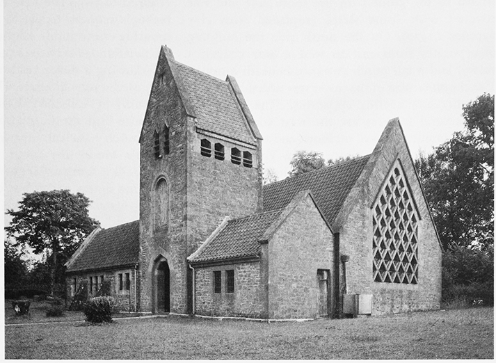
51. Church of St Edward King and Confessor from the north-west
Drummond immediately introduced changes in church services and started a choir. In the parish church the gallery was removed and the pews altered and Drummond himself scraped the church's walls to reveal its medieval paintings. (fn. 616) A chalice and paten of 1876 were bought by subscription. (fn. 617) Drummond's successors, particularly Edward Denny from 1886, made other innovations, including sung masses, the occasional use of vestments and incense, and services at Corpus Christi and other festivals. Denny faced vehement opposition, led by a churchwarden, and church life was seriously disrupted. The impasse was solved by Denny's departure in 1898, (fn. 618) his resignation apparently being forced by a noisy demonstration around the vicarage house for three days and nights. (fn. 619) On his arrival in Kempley Denny's successor received an address pleading for a simpler and more traditional Sunday morning service but he agreed only to conduct the monthly communion service, by then on the first Sunday, without music. There were several Protestant missions to Kempley Green during the 1890s and 1900s and local people continued to attend the nonconformist chapels there and at Fishpool. (fn. 620) In 1885 stock was substituted for Elizabeth Pyndar's endowment of the monthly communion service (fn. 621) and by 1890 the income from it fell short of £3. (fn. 622)
The Building of a Second Church
In 1902 work began on a new church near the temporary church. A project of William Lygon, 7th Earl Beauchamp, its foundations were laid before the earl entrusted its design to A. Randall Wells, recently clerk of works for the architect William Lethaby at Brockhampton church in Herefordshire. (fn. 623) The church, intended for High Church worship, was built of Forest of Dean sandstone and local timber with direct local labour. Wells's designs, in adopting Lethaby's 'primitive' style, adapted several elements used at Brockhampton and included a lychgate at the entrance to the churchyard. The chancel and nave are enveloped by a single steep roof, which drops almost to the ground on the south side and was covered with stone slates (replaced with clay pantiles c.1970). On the north side the building incorporates from east to west a lady chapel, a vestry, and a tall porch entrance beneath a tower. The chamber west of the tower was added in 1908 to accommodate heating apparatus. (fn. 624) The dominant architectural features are the west window filled with a diamond grid of mullions and transoms and the scissor-trusses of the open roof. The east wall is windowless. Simple details include triangular window heads and a saddle-back roof over the tower and the plain masonry is punctuated by carvings by Laurence Turner. A figure of Christ over the porch was executed by Wells assisted by the builder, Richard James of Brookland's Farm. (fn. 625)
The furnishings are mostly products of the Arts and Crafts Movement made by collaborators of Lethaby and Wells such as Ernest Gimson and Ernest Barnsley. (fn. 626) George Smallman of Fishpool was responsible for the ironwork. (fn. 627) The two roof figures which together with the decoration of a roof truss mark the division between nave and chancel were carved by David Gibb of London, a maker of ship figureheads. Earl Beauchamp donated a high-altar baldachin supported on baroque columns.
The Twentieth Century
Services were held in the new church from 1903 but before dedicating it to St Edward King and Confessor the bishop ordered the removal of an altar stone from the lady chapel and several other fittings; (fn. 628) they were reinstated soon after the bishop's resignation in 1905. (fn. 629) In 1907 an incoming vicar decided to use vestments only at principal festivals and not to revive the practice of sung masses every Sunday, and the number of candlesticks on the main altar of St Edward's was reduced to two. The new vicar also agreed, at the bishop's request, to use St Mary's church for the monthly communion service and in the summer for two Sunday services a month. (fn. 630)
Following a major restoration in 1913 St Mary's was used every Sunday. The restoration, funded primarily by voluntary donations, had widespread support within the diocese and beyond on account of the church's ancient frescoes. (fn. 631) Under the architect Temple Moore the tower was strengthened, the nave ceiling was raised, and the 12th-century south and west doors, which had been kept in the tower, were reinstated in the nave's doorways. New fittings and furnishings were acquired or given, a harmonium being installed in the place of the pew north of the chancel arch, and Blaisdon parish donated its old, 16th-century, font and Earl and Countess Beauchamp returned the tazza donated in 1705, (fn. 632) having bought it at a private sale in 1908. (fn. 633) One of the medieval bells, long damaged, was recast. (fn. 634)
Daniel Gethyn-Jones, vicar 1921–60, played a key role in the restoration of the frescoes in St Mary's between 1955 and 1958. (fn. 635) St Edward's was consecrated in 1934 and licensed for marriages in 1943, (fn. 636) and in 1975 it was made the parish church and St Mary's was declared redundant. (fn. 637) Kempley had a resident Anglican clergyman until the union of benefices in 1975. (fn. 638) After that the church was served from Dymock (fn. 639) and from 2000 by a team of ministers headed by a woman living in Redmarley D' Abitot. (fn. 640) The monthly communion service established by Elizabeth Pyndar's charity was supported by the Kempley charity in 2006. (fn. 641) The Baptist chapel at Kempley Green, where regular Sunday evening services ceased by the 1980s, was used for a Sunday school and occasional services in 2006. (fn. 642)