A History of the County of Gloucester: Volume 12. Originally published by Boydell & Brewer for Victoria County History, Woodbridge, 2010.
This free content was digitised by double rekeying. All rights reserved.
'Longhope', in A History of the County of Gloucester: Volume 12, ed. A.R.J. Jurica (Woodbridge, 2010), British History Online https://www.british-history.ac.uk/vch/glos/vol12/233-254 [accessed 30 April 2025].
'Longhope', in A History of the County of Gloucester: Volume 12. Edited by A.R.J. Jurica (Woodbridge, 2010), British History Online, accessed April 30, 2025, https://www.british-history.ac.uk/vch/glos/vol12/233-254.
"Longhope". A History of the County of Gloucester: Volume 12. Ed. A.R.J. Jurica (Woodbridge, 2010), British History Online. Web. 30 April 2025. https://www.british-history.ac.uk/vch/glos/vol12/233-254.
In this section
LONGHOPE
Map 11. Longhope 1870
LONGHOPE is a hilly and wooded parish lying 15 km west of Gloucester on Gloucestershire's ancient boundary with Herefordshire close to the Forest of Dean. Taken into the jurisdiction of the Forest in the early Middle Ages and among the places disafforested in the early 14th century, (fn. 1) Longhope was known after early lords as Hope Baderon in the mid 12th century and Hope Monmouth in the early 13th. (fn. 2) Woodland and carrying trades provided employment for many inhabitants and in the 17th century ironworks operated on several sites. In more recent times wood turning remained among the mainstays of the economy.
BOUNDARIES AND DIVISIONS
The ancient parish covered 3,153 a. (1,276 ha) in a rough circle taking in the summit of May hill in the north-east. (fn. 3) Its boundaries, marked mostly by ancient paths and streams, included on the south a tributary of the Longhope brook dividing Hope wood from the Flaxley woods and called 'Tinbridge Sith' in 1667 (fn. 4) and on the south-east the uppermost stretch of the Ley brook. In the north-west the parish projected between the old route of the Gloucester–Hereford road on the east and the Mitcheldean–Newent road on the west to a point at Lea Line. (fn. 5)
The parish contained two divisions for the purposes of civil government in the early modern period. (fn. 6) Although the precise boundary between the two parts was unknown at the end of the 19th century, (fn. 7) the lower division, in the south, was the larger. The upper division covered the northern end of the parish, including Dursley Cross, and contained the parish church. (fn. 8)
In 1935 106 a. below Bradley grove in the north-west was transferred to Mitcheldean. (fn. 9) In 1965 the small projection to the north at Lea Line was added to Lea (Herefs.) to leave Longhope with 3,034 a. (1,228 ha). (fn. 10)
LANDSCAPE
As indicated in its name the parish's primary feature is the valley of the Longhope brook. (fn. 11) It falls from 110 m in the north to 45 m in the south, and on both sides steep hills, cloven by small streams, rise above 150 m, reaching 217 m on Breakheart hill to the west and 296 m on May hill to the north-east. On the west the land is formed by Old Red sandstones of the Devonian period and on the north-east by older Silurian sandstones. (fn. 12) May hill was formerly known as Yartledon (later Yartleton) (fn. 13) and its summit, the site of a beacon where the neighbourhood traditionally kept watch and ward, (fn. 14) was the place for ancient May Day rites enacted by men from surrounding parishes. (fn. 15) Springs on Breakheart hill feed a tributary stream known in the early 17th century as Barley brook. (fn. 16) Another stream running down from Mitcheldean between Breakheart hill and Brimps hill to the south was, like the Longhope brook, dammed in several places to form ponds to power mills and ironworks. The east of the parish is drained by the Ley brook, which flows eastwards from a source at Royal Spring. (fn. 17)
Most cultivation in Longhope has always been in closes and orchards were being established by the end of the Middle Ages. The ancient woodland, of which Hope wood in the south was recorded in 1227, (fn. 18) was extensive and subject to common pasture rights. The top of May hill was cleared of its woodland, apart from Bearfoot (formerly Fairfoot) wood on the east side, (fn. 19) and remained common land until 1874. (fn. 20) At the inclosure a clump of fir trees on the summit, possibly first planted in the mid 18th century, (fn. 21) was reserved in a circle of 4 a. for the recreation of the inhabitants of Longhope and its neighbourhood. (fn. 22) Since then the clump has been occasionally renewed, trees to mark the Golden Jubilee of 1887 and the Silver Jubilee of 1977 being among new plantings. (fn. 23) The rest of the top of the hill was acquired by the National Trust in 1935. (fn. 24)
In 1841 there was an estimated 460 a. of woodland in Longhope. The largest area was Hope wood with 177 a. (fn. 25) and among the smaller areas were those south of Dursley Cross known in 1785 as Kiln and Coleshare (later Cot) woods. (fn. 26) Bradley grove, covering 52 a. on a spur in the north-west of the parish, was reduced in area in the mid 19th century (fn. 27) and again in the later 20th. (fn. 28) Woodland accounted for 392 a. in Longhope in 1905 (fn. 29) and new planting took place on the upper slopes of May hill in the 20th century. The land has been quarried in many places, particularly along the sides of May hill where continuous limestone outcrops (fn. 30) were extensively worked in the 18th and 19th centuries. (fn. 31) Earlier quarrying presumably created Crocket's Hole, a place near the hill's summit reputed in the early 18th century to have been a hiding place in time of religious persecution and civil war. (fn. 32)
ROADS AND RAILWAY
Two main roads from Gloucester wind through Longhope as continuations of a Roman road leading westwards from the city. (fn. 33) In the later 17th century, despite following narrow and in places very steep lanes, both were major routes towards Wales. That to Ross-on-Wye (Herefs.) and Hereford (fn. 34) ran over the southern end of May hill, on which a wayside cross marked a crossroads at Dursley Cross, (fn. 35) and continued on a curving course to Lea Line. There it crossed the road from Mitcheldean to Newent and descended Lea hill, once known as the devil's bowling green. (fn. 36) The Monmouth road, further south, (fn. 37) climbed from Little London before descending Hope's hill into the Longhope valley by way of Old Hill, a steep drop at a place known in the later 19th century as the Steps (fn. 38) near the bottom of which stood a wayside cross. (fn. 39) The road continued north-westwards up the valley for a short distance before turning west, away from the road leading up the valley to the parish church and a junction with the Ross road, to run along the Latchen and up the tributary valley towards Mitcheldean and the Forest of Dean. (fn. 40)
The Ross and Monmouth roads were turnpiked through Longhope in 1726 and 1747 respectively. (fn. 41) Both roads, together with the road from Mitcheldean to Lea Line which was part of the same trust from 1769, (fn. 42) remained turnpiked until 1880. (fn. 43) In the mid or late 1820s the Ross road, the route of which was likened to one of the plagues of Egypt, (fn. 44) was moved southwards at Dursley Cross and the Monmouth road was straightened through Little London and diverted southwards on its descent on Hope's hill to Longhope village. (fn. 45) Under an Act of 1833, the Ross road was diverted in the north-west corner of Longhope to take an easier route down Lea hill in a cutting south of Lea Line. The course there of the Mitcheldean–Newent road was also altered. (fn. 46) In the 1850s a section of the Ross road in the north-west was shifted again to the south to accommodate a railway. (fn. 47) A tollhouse erected near Hopesbrook in the 1840s was altered to face the new road to its south (fn. 48) but in 1871 the tollgate was further west, just outside the parish at the crossroads south of Lea Line. (fn. 49) In 1975 the road over Hope's hill was widened and a new road built south of the village to carry through traffic on the Monmouth road. (fn. 50)
Many old lanes and paths cross and climb the sides of the Longhope valley and of May hill, some later abandoned. Justy Path recorded on the western boundary in 1667 (fn. 51) may have been the Monmouth road. Jane Shell Lane, recorded in 1797, ran southwestwards to join the Monmouth road near the foot of Old Hill. (fn. 52)
A route from Dursley Cross to Mitcheldean, described in 1692 as a market way, ran southwestwards down the side of the Longhope valley (fn. 53) and was later known as Hobb's Lane. Yartleton Lane, which emerges from a criss-cross of lanes just above Dursley Cross, (fn. 54) runs north-westwards along the side of May hill and its highest section, over boggy ground, was made a public highway when the hill's summit was inclosed in 1874. (fn. 55) Lower down to the west Barrel Lane is the road branching off the Ross road northwards towards Aston Ingham (Herefs.). In the late 19th century the principal minor roads out of the village were Velthouse Lane leading southwards to Blaisdon and Hobb's Lane leading north-eastwards up to Dursley Cross. (fn. 56) Hobb's Lane has been reduced to a footpath for part of its course. Mill Lane leads southwards to Furnace Mill, where a stone bridge surviving over the Longhope brook provided a way towards the southern end of the parish below Hope wood. (fn. 57)
The railway line from Gloucester to Hereford opened up the Longhope valley as far as Hopesbrook by the Ross road in 1853. On the line's completion in 1855 a station opened beside the village. (fn. 58) The line closed in 1964. (fn. 59) The bridge that carried it over Barrel Lane was in place in 2005.
POPULATION
There were at least 13 tenant households on the Longhope estate in 1086 (fn. 60) and 54 men and women were assessed for tax in Longhope and its hamlet of Blaisdon in 1327. (fn. 61) In Longhope alone 45 men were named in a muster of 1542 (fn. 62) and there were c.180 communicants in the parish in 1551 (fn. 63) and 63 households in 1563. (fn. 64) Two hundred and ten communicants were recorded in 1603 (fn. 65) and one hundred families in 1650. (fn. 66) The population was estimated at 500 c.1710 (fn. 67) and 470 c.1775, (fn. 68) the latter figure possibly an underestimate for in 1801 the population was 636. There was steady growth to 1,104 in 1861 but the population then declined to 971 in 1881 and 863 in 1901. After the First World War it rose to 957 in 1931 and, with only small losses from the boundary changes of 1935 and 1965, it grew from 1,031 in 1951 to 1,491 in 1991, most of that increase accompanying new building in the village after 1971. The population in 2001 was 1,474. (fn. 69)
SETTLEMENT
Medieval settlement in Longhope was scattered. The village developed much later where the road to the parish church branched off the Monmouth road in the Longhope valley. The high ground was sparsely settled but encroachments on the commons on the eastern side of the parish in the 18th and 19th centuries led to the creation of groups of cottages on some of the hillsides there.
THE VILLAGE
The medieval parish church, 1 km from the old Monmouth road, stands low down by the line of a former road across the valley. Court Farm, to the east, occupies the site of the medieval manor (fn. 70) and was known as the Court House in the early 18th century, when the Longhope brook flowed between it and the churchyard. (fn. 71) The vicarage house, recorded from the early 15th century, stood a little to the south. (fn. 72) The house there ceased to be used by the vicars at the end of the 18th century (fn. 73) and became a farmhouse. (fn. 74)
During the later 18th and early 19th century several houses and cottages were built along the Monmouth road into the southern end of the road to the church (Church Road). Of the older dwellings strung out on the two roads most are of the 17th or early 18th century but The Cruck House in Church Road contains the remains of a 15th-century hall. (fn. 75) Further north, in a small cluster opposite the church, Marle Cottage, once the property of the parish, (fn. 76) dates from the 16th century and Court Leet, to its north, was built in the later 17th century. (fn. 77)
On the Monmouth road the Plough inn, that stood opposite Knapp House near the foot of Old Hill, (fn. 78) survived until road widening in 1975. (fn. 79) Of the newer houses by the Monmouth road Coglan House, opposite the entrance to the Latchen, was occupied by the landowner Robert Coghlan (fn. 80) (d. 1803 or 1804). (fn. 81) The Temple, an early 19th-century gentleman's residence, has become a hotel.
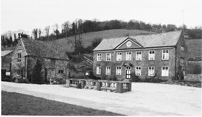
Elsewhere the Manor House, to the north beyond the church, occupies the site of the seat of the Yate family. (fn. 82) Rebuilt for the Probyns in the early 19th century, (fn. 83) it is set in grounds intersected by the Longhope brook and with an approach from the Ross road (fn. 84) and was a hotel in the mid 20th century (fn. 85) and a nursing home later. The Old Rectory, south-west of the church, was built as the vicarage house in the later 1820s with a schoolroom in an outbuilding. (fn. 86) The house became a nursing home in the late 20th century.
From the mid 19th century more houses were built at the south end of Church Road and to the southeast by the new line of the Monmouth road up Hope's hill. New building also took place on the Monmouth road in the Latchen. There a small house opposite a pound (fn. 87) was rebuilt by the Norwich Union Fire Office in 1852, the year after it had burnt down, (fn. 88) and another house, further west, was replaced in the 1860s by Tyndale Villa, built by Evan Butler, a Cheltenham carpenter. (fn. 89) A horse trough placed by parishioners opposite the entrance to the Latchen in 1904 (fn. 90) was used for a floral display in 2007. A memorial to local men killed in the First World War, taking the form of a recumbent lion on a stone pedestal at the foot of Old Hill, was given by its creator, Walter Davis of Hereford, and unveiled in 1928. (fn. 91) Private and council building both contributed to the development of the village in the 20th century. Council houses were built on Church Road, the first being three pairs near the church in the early 1930s (fn. 92) and several more, including an estate of six pairs, following in the late 1940s and early 1950s. (fn. 93) Other new buildings after the Second World War included a police station on Church Road. (fn. 94) In the 1970s and 1980s more houses were built in the Latchen (fn. 95) and private developers built many bungalows and detached houses on the west side of the village. Some of the new houses encroached on Nupend, an ancient farmstead (fn. 96) where the house had been rebuilt in the early 19th century. (fn. 97) Private development continued on land in Church Road in the early 21st century.
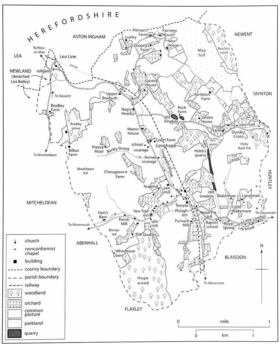
52. Pound House
OUTLYING SETTLEMENT
The East Side
Several farmhouses and cottages stood on Hope's hill in the early 18th century. (fn. 98) Zion House, below the brow of the hill, dates from the mid 19th century, being the manse of a chapel built there earlier, in 1846. (fn. 99) To the east Royal Spring, a farmhouse south of the Monmouth road at the place called Blackmoor (or Blackmire) green in the early 18th century, was rebuilt by William Kendale (d. 1778), a Gloucester innholder. (fn. 100) In the mid 1950s an estate of ten council houses was built on the opposite side of the road right up against Little Blakemore, (fn. 101) a farmhouse that was copyhold until 1913. (fn. 102) The house at Blakemore, to the north, was part of one of the larger farmsteads in Longhope in the mid 19th century (fn. 103) and was the centre of a farm park in 2006. Several small farmhouses used to stand at Lonehead, high up to the north-east of Little Blakemore; (fn. 104) the last remaining house there was enlarged in the late 20th century.
Towards the eastern boundary small farmhouses and cottages straggle along the Monmouth road in the place known as Little London by the early 18th century. (fn. 105) In the late 19th and early 20th century a number of dwellings there were rebuilt or refronted and new buildings included a house with a shop in matching style. Building on the common on the hillsides north of the road had begun by the early 18th century (fn. 106) and led to the creation of the scattered settlement called the Slade.
In the south-east of the parish a few houses stand at irregular intervals along Velthouse Lane. The oldest is Peach Tree Cottage, a small 17th-century dwelling, at the north end. (fn. 107) Those built in the later 20th century face west across the valley towards Hope wood. In Mill Lane the principal buildings are associated with the former Furnace Mill and the tannery that operated next to it in the 19th century. (fn. 108)
The West Side
On the west side of the parish several farmsteads and mills were built along the valley leading up to Mitcheldean. The house at Brook Farm, sandwiched between the Monmouth road and the stream, dates from the 17th century. (fn. 109) The farmstead at Hart's Barn, further up the valley, was probably named after the family of Robert the Hart (fl. 1380). (fn. 110) Its house, long the property of the Sergeaunt family, (fn. 111) was enlarged in the early 18th century (fn. 112) and the outbuildings, mostly dating from the 18th and 19th centuries, were converted in mid 1990s as a craft and veterinary centre. (fn. 113) Set back in a combe on the south side of the valley the Quabbs was a copyhold cottage in the early 18th century. (fn. 114)
Three early farmsteads stand high on Breakheart hill, to the north. Chessgrove Farm, to the east of which was a common with only one other dwelling on its edge in the early 18th century, (fn. 115) had a large collection of buildings in the 19th century. (fn. 116) Preece Moor, further north, is recorded from 1608 (fn. 117) and Bilbut Farm, over the brow of the hill looking to the west was called Great Bilbut in 1619. (fn. 118) To the north Forest Court, on the west side of Bradley grove, was built as a country house, on land taken from the wood, shortly before 1870 and was known originally as Bradley Grove and later as Bradley Court. (fn. 119) In the 20th century it was in turn an agricultural college, a riding school, (fn. 120) a hotel, and a nursing home. (fn. 121) The farmstead at Lyndors Farm, north-east of Bradley grove, was established in the 20th century. (fn. 122) Lower down to the west two farmsteads stood on the Mitcheldean–Newent road. Known as Great and Little Bradley, both belonged to the curates (later vicars) of Flaxley from 1737 (fn. 123) and Little Bradley, the southern one, was demolished before the mid 19th century. (fn. 124)
There are also small groups of houses in the west of Longhope by the Ross road in the area known in the late 19th century as the Upper End. (fn. 125) The older houses date mostly from the 18th and 19th centuries and included clusters of farmsteads at the end of Barrel Lane and further along the road at the place originally called Boxbush. (fn. 126) Upper Boxbush House, south-west of the road, is a mid 17th-century farmhouse that belonged to the curates (later vicars) of Maisemore between 1745 and 1925. (fn. 127) The Farmer's Boy opposite it was a small farmhouse in the mid 18th century. (fn. 128) Further along the road Dean End high up at Lea Line was built in the early 19th century to replace a dwelling on a slightly different site and was known originally as Blenheim House. (fn. 129)
The North End: May Hill
Scattered settlement has taken place on the lower slopes of May hill in the north-east of the parish. On the southern slopes dwellings probably existed at Rock Farm and Jordan House, above the Ross road, by 1327 when John and Sibyl Hunter and Roger Jordan were recorded in Longhope; (fn. 130) Rock Farm (sometimes the Rock) was called Hunter's in 1633. (fn. 131) A residential park lower down to the west on the road originated as a caravan park in the mid 1950s. (fn. 132)
There was also early settlement higher up to the east at Dursley (sometimes Durley) Cross. (fn. 133) Roger of Durley was among those recorded in the parish in 1327 (fn. 134) and the name Durley was used for land some way south of the Ross road. (fn. 135) Cross Farm, a copyhold known as Lower House in 1667, (fn. 136) stands south of the old line of the Ross road and its house, probably of late medieval date, was rebuilt in the early 18th century. (fn. 137) In the early 18th century a few cottages and small farmsteads stood higher up to the north-east on the edges of the commons on May hill. (fn. 138) More cottages were built by squatter development on the commons in the later 18th and early 19th century (fn. 139) and much scattered building has taken place in the area since the inclosure of 1874. (fn. 140) To the north, higher up the hill, there was a house in Bearfoot wood in the early 18th century (fn. 141) and a few cottages on the wood's edge, including at Crocket's Hole, in the mid 19th. (fn. 142) A cottage, formerly the keeper's lodge, (fn. 143) remained at the southern edge in 2005.
May Hill House, standing north-west of Dursley Cross on the site of Yartleton Farm, (fn. 144) perhaps the copyhold Yartleton House in 1642, (fn. 145) took its name on its creation as the residence of H.A. Pringle in the 1930s. May Hill Lodge, further along Yartleton Lane, was an entirely new house built for Pringle. (fn. 146) The few dwellings further north-west were built on the edge of the common, Wingate's Farm being in 1826 a cottage known as the New House. (fn. 147) Of the farmsteads below the lane Coopey's Farm, near the foot of the hill, contains a cottage of the early 17th century. The former farmhouse of Pitman's Farm is later and in stone, and a stone outbuilding to the south-east has been converted as a dwelling. The house at Fairfield, higher up to the east, was built in the mid 19th century (fn. 148) and was known originally as Fairview House. (fn. 149)
Lower down to the west a few houses are spaced irregularly on Barrel Lane. While some cottages there were rebuilt in the 19th century, the older surviving buildings include The Old Farm and Gaston Cottage in a cluster of dwellings at the bottom of a lane off May hill, the latter being where the vicar C.M. Dighton lived in 1825. (fn. 150) The cottage at Luxley, in the north, was part of a copyhold farmstead in the 19th century. (fn. 151)
BUILDINGS
Early Buildings
Two of Longhope's oldest surviving domestic buildings were substantial houses with open halls. The stone-walled Cruck House in Church Road retains a cruck truss and the remains of a spere truss from a 15th-century hall, into which a floor and a chimney were inserted in the 16th or 17th century. Marle Cottage opposite the church has a complete 16th-century cross wing. The wing, which retains close studding indicative of a high-status house, was extended westwards by a bay in the 17th century. (fn. 152)
Court Leet, north-west of the church, has three bays with two whole storeys and attics and a lobby entrance and a rear outshut. (fn. 153) It was built perhaps for Thomas Nourse (d. 1675), who was assessed on three hearths in 1672. Nourse Yate, his successor as lay rector, (fn. 154) had a 'good seat near the church' c.1710. (fn. 155) The construction and accommodation of the mid 17thcentury Upper Boxbush House is also of high quality with a lobby-entrance plan, three rooms on each of its two floors, and some decoration in the heated room over the parlour. A west bay of rougher construction appears to have been built as a singlestoreyed lean-to workshop or service room with a separate entrance. (fn. 156) In the southern part of the village Knapp House, on the Monmouth road, is of two storeys with attic and four rooms in line and was also large enough to have been among the 12 houses that in 1672 had three or more hearths. (fn. 157) Two smaller 17th-century houses on the old Monmouth road, and one further west, have, like Upper Boxbush, upper rooms partly within their roofs (fn. 158) and Peach Tree Cottage in Velthouse Lane has only two rooms and an attic. (fn. 159) On the lower slopes of May hill the similar house at Coopey's Farm was originally two-bayed (fn. 160) and Rock Farm has a house that was first built on the same scale. (fn. 161) Dam Barn Cottages in Church Road occupy a long timber-framed range erected in the late 17th or early 18th century (fn. 162) possibly for industry and used in the mid 19th century as a farm building. (fn. 163)
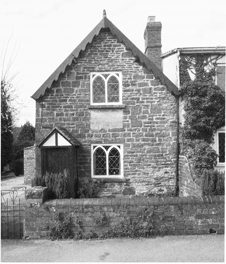
53. Marle Cottage
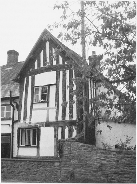
54. Upper Boxbush House
The 17th-century houses described above were timber-framed structures with chimneys and gable walls on stone plinths. Hart's Barn appears to have been rebuilt entirely in stone in the middle of the century by Edward Sergeaunt. (fn. 164) With Edward one of only two householders assessed on four hearths in 1672, (fn. 165) it was two-storeyed and had at least three bays, attics, and cellar. A surviving window in the gable end has an ovolo-moulded mullion.
55. Hart's Barn from the south-east in 1996
Domestic and Other Buildings from the Eighteenth Century
Most probably after 1702 by William Sergeaunt, Hart's Barn was extended west to become the most fashionable house in the parish. Its front was slightly raised and, above the cellar, was given a two-storeyed brick façade, with a central pediment that rests on a coved cornice, a plain semicircular doorhood, and timber cross-casement windows. A rear projection was added to house a staircase with twisted balusters. New stone outbuildings included a cowhouse with hayloft and stables and a granary south-west of the house. (fn. 166) The farmhouse at Dursley Cross was also rebuilt in the early 18th century, when part of the Colchester family's estates; (fn. 167) the new two-storeyed front range has attics and cellars and a gabled stair projection, is almost entirely faced in Flemish-bond brick, and has timber windows. The house retains a cruck within the stone-cased rear wing. (fn. 168) In the south of the village the remains of a tall 18th-century brick house, perhaps also with a stair projection, can be discerned at Coglan House, which was built as a gentleman's residence probably by Robert Coghlan (d. 1803 or 1804). (fn. 169)
Although timber framing continued to be used into the 18th century for poorer dwellings such as the tworoom Walnut Cottage at Little London, (fn. 170) most new building in Longhope was in stone or brick. Stone rubble quarried from the slopes of May hill was much used for small houses, such as the early 18th-century Gaston House, and for outbuildings. Brick was often used to form openings in rubble walls, as can be seen in the small house and outbuildings at Pitman's Farm. In the early to mid 19th century unsquared stone was used for a field barn and cattle shed at Preece Moor. (fn. 171) Court Farm was rebuilt in the same manner but on a larger scale with farm buildings round three sides of a yard and Bilbut Farm, through improvements funded by the landowner Edmund Probyn, acquired a new house, a plain three-bayed villa dated 1857, and a symmetrical layout of outbuildings. (fn. 172) At Hart's Barn by the late 1870s a large barn and associated buildings had been built north-east of the house around a new farmyard higher up the slope. (fn. 173)
In the early 19th century several large houses were built in stuccoed classical style. The four-square Manor House, north of the church, was provided most probably for John Probyn about the time he became lord of the manor in 1819 (fn. 174) The house, which had a stable court to the south and a pleasure ground with a fishpond to the north, (fn. 175) is of 2½ storeys with a hipped roof with projecting eaves and its main east façade is unadorned except for a slender doorcase with open pediment and a central first-floor window with intersecting glazing bars, a pattern repeated in some windows of the stable block. (fn. 176) The Old Rectory, south-west of the church, was begun in 1825 by the vicar C.M. Dighton and completed by 1829 by his successor Edmund Probyn. Its neoclassical main façade, with recessed centre and porch with Tuscan columns in antis, originally had two projectings bows. An outbuilding erected at the same time for a schoolroom (fn. 177) is joined to a simple singlestoreyed rock-faced range with red brick dressings built as a school in 1911 to a design by R.S. Phillips. (fn. 178) The Temple, in the south of the village on the old Monmouth road, was built as a gentleman's residence probably by the solicitor Solomon Coleman, its occupant in the late 1830s. (fn. 179) It has a slightly irregular five-bayed façade with two storeys and a Tuscan porch. Its outbuildings in 1913 included a range that had accommodated a coach house and stabling. (fn. 180)
Increasingly builders took advantage of the parish's topography to choose sites that commanded views. The classical Blenheim House (Dean End) at Lea Line had been built by 1841, when it was a boarding school, (fn. 181) and was much enlarged later in the same late Georgian style. Bradley Grove (later Bradley Court and in 2007 Forest Court) was built high up in the west in the late 1860s as a country house for Osman Barrett, a Forest of Dean mine owner. Designed by T.H. Rushforth of London in an unambitious Tudor-Gothic style, it was built of red sandstone with Bath stone dressings (fn. 182) on an L plan with a northern service court. The double-pile main block has to the west a long façade of 2½ storeys varied only by gables and shallow bay windows and to the east a two-storeyed entrance front with a Gothic doorcase and staircase window. The interior of the house, where Barrett and his family lived with seven servants in 1871, (fn. 183) was equally conventional, the main hall containing an overmantel in Jacobethan style. (fn. 184) The house had two lodges, (fn. 185) one of them in a U-plan coach and stable block with tourelle on the southern edge of the small park.
Throughout the 19th century small villas in late classical style were built on the main roads, such as Jordan House and Hopebrook on the Ross road, both three-bayed and early 19th-century. (fn. 186) The red brick Zion House on the Monmouth road on Hope's hill was the mid 19th-century manse of the Baptist chapel there. The chapel, built back from the road in 1845 and 1846, (fn. 187) is modest with a rendered north façade with gable and a door flanked by two roundheaded windows. A schoolroom added in 1866 and enlarged in 1893 is at the rear. (fn. 188) In the village a number of villas built in the southern part after the railway station opened there in 1855 were occupied by private residents. (fn. 189) In the Latchen the rebuilding in 1852 of Pound House as a Gothic two-roomed 1½storeyed cottage standing end on to the road presumably repeated in stone the form of the timber-framed cottage that burned down on the site in 1851. (fn. 190) The development of the village, and particularly its southern end, was supported in the early 20th century by the provision of a hall; built of stone and brick on a slope in the Latchen, its basement housed committee and store rooms. (fn. 191) The mission room at the Upper End in 1901 was a small wooden building with Gothic windows attached to a house off the Ross road at the bottom of Barrel Lane. (fn. 192)
The practice of building on May hill to command a wide prospect continued in the 20th century. In the 1930s the landowner H.A. Pringle added to the buildings at Yartleton Farm to create May Hill House, using ashlar to face a new austere block of reception rooms that look south-westwards over the Longhope valley. May Hill Lodge, one of several new houses built by Pringle near by, is pebble-dashed and in more conventional cottage style. (fn. 193) Since the Second World War older dwellings such as Yartleton Oak Cottage have been enlarged. One of the new houses, constructed on the prefabricated Huf system, incorporates large areas of glass.
Industrial Buildings
The once prolific industrial activity in Longhope has left little built evidence although many of its sites alongside the Longhope brook and the main tributary can be traced. (fn. 194) In the village the turnery of James Constance & Sons included a tall chimney and other buildings (fn. 195) that were pulled down in the late 20th century. South of the village stone buildings stand east of the Longhope brook at Furnace Mill, where a corn mill and a tannery operated side by side in the mid 19th century. (fn. 196) The mill house, of the late 18th or early 19th century, has a plain three-bayed west front of three storeys and an east range spanning the mill race. (fn. 197) The tannery buildings to the north, between brook and leat, have not survived and a house, to the north-east, has been almost concealed by late 19th- and 20th-century additions. At Dursley Cross a two-storeyed house with attics on the Ross road was built in 1850 to accommodate a steam flour mill. (fn. 198)
MANOR AND ESTATES
During the Norman settlement in the later 11th century Longhope became the possession of the lords of Monmouth. Under the manor, which was acquired by the Talbot family in the mid 13th century and passed to the Grey family in the early 17th, the parish was divided between numerous landholders, (fn. 199) including the Baynhams in the early 16th century. (fn. 200) In the 16th and 17th centuries the Nourse and Sergeaunt families built up estates in Longhope (fn. 201) and William Steventon (d. 1647) of Dothill in Wellington (Salop.) owned land on the boundary with Mitcheldean. (fn. 202) In the early 18th century, when Longhope had 36 resident freeholders, (fn. 203) the Colchesters of Westburyon-Severn were among its more prominent landowners (fn. 204) and the Probyns of Newland became the chief landowners on their acquisition of the manor. (fn. 205) Small gifts of land and cottages beginning in the late 14th century created an endowment for parish charities (the Parish Charity Lands trust) that eventually covered over 70 a. in scattered pieces in Longhope. (fn. 206)
Although much copyhold was enfranchised on the sale of the manor in the mid 1720s (fn. 207) and in the 1880s, (fn. 208) some land remained copyhold until after the First World War. (fn. 209) Most of the Probyns' land was sold to the Sharpe family in 1872 (fn. 210) and among the many other landowners in the early 20th century (fn. 211) were M.W. Colchester-Wemyss, who owned a farm at Bradley that had belonged to the curates of Flaxley from 1737 to 1880, (fn. 212) and the trustees of Osman Barrett (d. 1890). (fn. 213) Barrett, a colliery owner in the Forest of Dean, (fn. 214) had acquired land at Chessgrove and Preece Moor that had been part of the Blunt family's Huntley Court estate. (fn. 215)
LONGHOPE MANOR
An estate at Longhope held in 1066 by the royal thegns Forne and Wulfheah (Ulfeg) (fn. 216) probably also covered Blaisdon. (fn. 217) It was presumably among the lands that after the Conquest came to Wihanoc, lord of Monmouth, for his nephew and successor William son of Baderon held the estate in 1086, when it was assessed for geld at five hides. (fn. 218) William's son Baderon of Monmouth confirmed Longhope church to Wihanoc's foundation Monmouth priory (fn. 219) and the Longhope part of the estate passed to Baderon's son Gilbert of Monmouth (fn. 220) (d. 1190). Gilbert's son and heir John of Monmouth (d. 1248) owed the service of a knight's fee from Longhope (fn. 221) and the widow of his son John (d. 1257) held the estate in dower. (fn. 222) In 1267 Prince Edward granted the lordship of Monmouth to his brother Edmund (fn. 223) (d. 1296) and the overlordship of Longhope manor thereby descended with the earldom (later dukedom) of Lancaster. (fn. 224)
Gilbert Talbot, who held the manor by grant from Prince Edward, died in 1274 and was succeeded in it by his son Richard (fn. 225) (d. 1306). Richard's son and heir Gilbert, Lord Talbot, forfeited it temporarily following his capture at the battle of Boroughbridge in 1322 (fn. 226) and was granted free warren in the demesne in 1328. (fn. 227) From Gilbert (d. 1346) the manor descended evidently in direct line to successive Lords Talbot, Richard (fn. 228) (d. 1356), Gilbert (fn. 229) (d. 1387), and Richard (fn. 230) (d. 1396). Richard's widow Ankaret, who married Thomas Neville, Lord Furnivale (d. 1407), (fn. 231) retained the manor and was succeeded in it in 1413 by her son Gilbert Talbot, Lord Talbot (fn. 232) (d. 1418). His heir, his infant daughter Ankaret, (fn. 233) died in 1421 and the manor passed to her uncle John Talbot, who was created earl of Shrewsbury in 1442. The manor then descended with that earldom, (fn. 234) Catherine, widow of John Talbot (d. 1473), holding it in dower, (fn. 235) and it was inherited from the 7th earl, Gilbert Talbot (d. 1616), by his daughter Elizabeth, wife of Henry Grey (d. 1639), Lord Grey of Ruthin and from 1623 earl of Kent. After Elizabeth's death in 1651 (fn. 236) it passed to Anthony Grey, earl of Kent, (fn. 237) and his mother Amabel, dowager countess of Kent, held it during his minority. (fn. 238) Anthony (d. 1702) was succeeded by his son Henry. He rose to the status of duke of Kent in 1710 and sold off his family estates in and around Longhope in the mid 1720s. (fn. 239)
Sir Edmund Probyn of Newland, who acquired the manor, (fn. 240) died in 1742 leaving it to his nephew John Hopkins. From John, who took the surname Probyn (fn. 241) and died in 1773, (fn. 242) it descended, from father to son, (fn. 243) to Edmund Probyn (fn. 244) (d. 1819), Ven. (later Very Revd) John Probyn (d. 1843), (fn. 245) and John Probyn (fn. 246) (d. 1863). His son and heir Edmund, who became lord of the manor in 1855, (fn. 247) sold most of the land in 1872 to F.W. Sharpe, a Derbyshire clergyman, but kept some of it, notably Hope and Bearfoot woods, with the manorial rights (fn. 248) and retained most of the top of May hill when common rights there were extinguished. (fn. 249) In 1891, the year after Edmund's death, the manor belonged to Wilmot Inglis Jones (fn. 250) of Derry Ormond (Cardiganshire). Jones, who changed his surname to Inglis-Jones in 1899, (fn. 251) sold the land in 1917 to H.A. Pringle. (fn. 252) Pringle sold Hope wood to the Crown in 1918 (fn. 253) and Jones, the last recorded lord of the manor, died in 1949. (fn. 254)
The Manor House
Away from the site of the manor east of the parish church (fn. 255) the Manor House stands 265 m to the north towards the Ross road. Presumably in the place of the house with five hearths occupied in 1672 by Thomas Master (d. 1682), a member of a Cirencester gentry family, (fn. 256) it dates from rebuilding in the early 19th century of a house that had belonged to Yate Bromwich, a relative of Master according to heraldic evidence (fn. 257) and a descendant of the Nourse family. The Nourses were established in Longhope by the mid 16th century (fn. 258) and Richard Nourse by will dated 1590 left his house and land there to his grandson Thomas Nourse, a minor. (fn. 259) Thomas, described in 1651 as a gentleman, enlarged his estate, acquiring land from John Ayleway in 1669 (fn. 260) and the rectory. At his death in 1675 he was succeeded by his grandson Nourse Yate, who gave the impropriation to the vicarage in 1701 (fn. 261) and retained a substantial estate c.1710. (fn. 262) His widow Priscilla (d. 1720) (fn. 263) owned the estate in 1717 and the main house and 120 a. were copyhold (fn. 264) until 1726 when his son and heir Charles acquired their freehold. At Charles's death in 1730 the estate passed to his surviving sisters, Mary (d. 1761), Priscilla (d. 1763) wife of Lancelot Bromwich (d. 1752), Henrietta (d. 1752), Arethusa (d. 1752), and Frances (d. 1747). (fn. 265) The sisters sold some land and on Priscilla's death the rest passed with the main house to her son Yate Bromwich, vicar of Longhope. In 1774, soon after his death, his sister Priscilla Bromwich sold the estate to John Howell (fn. 266) (d. 1778) and from him it passed to his grandson Edmund Probyn, the lord of the manor. (fn. 267)
The Yates' house, part of which had been leased in 1759 to a farmer, (fn. 268) was rebuilt as the Probyns' residence and became known as the Manor House about the time John Probyn, rector of Abenhall and archdeacon (later dean) of Llandaff, inherited the manor in 1819. (fn. 269) In 1872 Edmund Probyn sold the house with 687 a. to Revd Francis William Sharpe (fn. 270) (d. 1873). Sharpe's widow Mary (d. 1880) retained the estate and his eldest son William Granville Sharpe (d. 1890) devised it to a cousin, John Charles Sharpe of Byfleet (Surrey). In 1909 he conveyed the estate to his son Revd. Charles Henry Sharpe, (fn. 271) the founder of a religious community at More Hall in Stonehouse, (fn. 272) and in 1918, at the break up of the estate, the house was bought with some land by Henry Arthur Pringle, (fn. 273) already a landowner in the parish. (fn. 274) Pringle, who moved to a new house on May hill in the mid 1930s, (fn. 275) died in 1939 and was survived by his only child Margaret, wife of R.W.J. Pringle-Nicholson (d. 1940). (fn. 276)
OTHER ESTATES
Hart's Barn
The house called Hart's Barn, in the west of Longhope by the Monmouth road, was part of an estate or farm owned by Nicholas Rowles (d. 1608), a merchant whose son Arthur lived in Longhope in 1608. (fn. 277) The house was acquired by John Sergeaunt of Mitcheldean, who had inherited land at Whitemoor (fn. 278) and at his death in 1615 was succeeded by his son Edward, a minor. (fn. 279) Edward, who was a Longhope churchwarden immediately after the Restoration, (fn. 280) lived at Hart's Barn and left the house and its lands at his death in 1698 to his son John. John released the estate in 1702 to his son William and William settled it in 1731 on the marriage of his son John (fn. 281) (d. 1765). (fn. 282) John's son John, (fn. 283) vicar of Awre, left Hart's Barn at his death in 1780 in turn to his brother Richard and to Richard's son John. (fn. 284) Richard died in 1802 and after John's death, in Philadelphia in 1820, the estate passed in turn to his mother Margaret (d. 1837) and his sisters Margaret, Ann, Joanna, and Mary. Margaret, who married Hugh Thompson Martin, died in 1845 leaving her share to her grandson Martin Wheeler Hooper (d. 1859). In 1859 Mary conveyed her share to her nephew Richard Hall, then of Baglan House in Neath (Glam.). From Richard, who acquired the other interests in the estate (c.96 a.), (fn. 285) Hart's Barn passed to his daughter Mary, the wife of John Hobart Culme-Seymour (d. 1887), and she sold it (fn. 286) in 1921 to Charles C. Few (fn. 287) (d. 1965). (fn. 288)
Longhope Rectory
In 1291 Monmouth priory's portion in Longhope church as rector (£3 6s. 8d.) was worth less than that of the vicar (£4). (fn. 289) In 1324 the prior took two thirds of the church's income and received a pension from the other third. (fn. 290) Later the vicar paid the priory a pension of 5s. and in 1525 the then vicar acquired a lease of the priory's rectory estate, made up of the tithes of the parish, for the term of his incumbency for a rent of 21s. 8d. (fn. 291)
In 1549 the Crown sold the rectory to Robert Wood (fn. 292) and he sold it, together with the patronage of the vicarage, to Thomas Baker of Milton Keynes (Bucks.). (fn. 293) Although he left land in west Gloucestershire to John Nourse of Milton Keynes, the history of the Longhope impropriation after Thomas's death in 1559 (fn. 294) is unclear. John Baker presented to the vicarage in 1577 (fn. 295) and Richard Nourse's duty at that time to maintain the church's chancel passed with the farm of the rectory to Nicholas Rowles before 1600. (fn. 296) In 1603 the rectory belonged to a Worcester man surnamed Hall (Hawle) (fn. 297) and in 1616 John Hall of Longhope conveyed it to James Cadell, a Bristol pewterer. James was succeeded a year later by his brother John, similarly a pewterer. Following his bankruptcy the rectory, which included many cash payments from parishioners, (fn. 298) was sold in 1630 to Nicholas Roberts, owner of an estate near by in Westbury-onSevern. (fn. 299) It later passed to Thomas Nourse, to whom Richard Halford and his wife Joan, Margery Morgan, and Walter Hugill or Hubarne and his wife Cecily quitclaimed it in 1674. (fn. 300) Thomas (d. 1675) left it with his lands in Longhope to his grandson Nourse Yate (fn. 301) and he settled the impropriation, made up mostly of the tithes of the parish, on the vicarage in 1701. (fn. 302)
ECONOMIC HISTORY
Although primarily a rural parish Longhope had a long industrial tradition embracing iron making, quarrying, wood turning and other woodland crafts, and tanning.
AGRICULTURE
The Middle Ages
In 1086 the Longhope estate, which may have included Blaisdon, was worth £5 compared with £8 in 1066. It had two ploughs in demesne and 3 slaves, and its tenants, 12 villans and 1 bordar, had 12 ploughs between them. (fn. 303) While eight ploughteams were recorded in Longhope in 1220 (fn. 304) the manorial demesne comprised 60 a. of arable and 8 a. of meadow in 1274. At that time free tenants held other land and customary tenants held 16½ yardlands for cash rents and, at Christmas, a render of pepper. In addition two mondaymen, presumably holding land once subject to Monday work, owed the same smaller cash rents as five cottagers. (fn. 305) In 1322, during the Crown's temporary seizure of the manor, wheat was sown on 36 a. of the demesne. (fn. 306)
While the steeper land is not suited for ploughing, medieval and later ridge and furrow covers some gentler slopes and hilltops of the parish. (fn. 307) The regular pattern of the closes high on Breakheart hill near Chessgrove Farm suggests that their origin was much earlier. Orchard cultivation (fn. 308) produced yields substantial enough for pear and apple tithes to merit mention alongside corn and hay tithes in the late Middle Ages. (fn. 309) Sheep farming provided employment for at least one shepherd 1327. (fn. 310) The extensive woodland, recorded in 1086 as part of William son of Baderon's estate in Huntley, (fn. 311) was common pasture throughout the year (fn. 312) and in the late 13th century the lord of the manor claimed an entitlement to common rights within Flaxley abbey's woods in adjoining Flaxley. (fn. 313) Longhope maintained rights of common on the royal demesne woodland of the Forest of Dean after it was taken out of the Forest's jurisdiction in the early 14th century. (fn. 314)
The Early Modern Period
Names recorded in 1780 might indicate that the parish once had a north field and a south field (fn. 315) but in the early 18th century, when there were several strips of land on the side of May hill, most cultivated land was in closes. (fn. 316) Despite piecemeal encroachment much land, both woodland and pasture, remained common. On the east side of the parish a string of commons, largely cleared of woodland, extended northwards above the Monmouth road, where they were open to Huntley wood common to the east, and over Holly Bush hill to Yartleton on May hill. In the early 18th century, when there were clusters of encroachments at Dursley Cross and elsewhere, they covered some 441 a. (fn. 317) and Chessgrove common covered 21 a. in the west, on the far side of the Longhope valley. (fn. 318) From the later 1720s small-scale piecemeal inclosure and cultivation was facilitated by the pragmatism of the Probyns, the lords of the manor, in granting leases to cottagers. (fn. 319) In the mid 18th century the parish paid 3s. 4d. herbage money for common rights in the Forest of Dean. (fn. 320)
Longhope's numerous farms (fn. 321) varied considerably in size. Some were owner-occupied; 36 freeholders lived there c.1710 (fn. 322) and there were 25 freeholders, some of them also tenants, under the manor in 1717. At that time, when two leaseholds were in hand, the manor had 22 tenants by lease or agreement for lives with heriots payable, 81 copyhold tenants, and 3 free benchers without heirs. At least two holdings, one of them centred on the Court House, were over 100 a. and several, including Bilbut, Hunter's, Great Bradley, and Boxbush, were over 50 a. Most of the rest were much smaller, usually less than 20 a., and many copyholders were cottagers with 1 or 2 a. (fn. 323) In 1794 the largest farm on Edmund Probyn's estate was made up of holdings of 172 a. and 77 a. The estate's smaller tenancies, all held separately, contained 81 a., 73 a., 64 a., 44 a., 23 a., and 19 a. (fn. 324)
Farming leases granted by the lord of the manor often required planting of new broadleaved trees but in the 17th and 18th centuries they increasingly requested regular planting of new stocks for apples and pears. (fn. 325) Local cider did not keep long (fn. 326) and apples from Longhope were being transported along the Severn in the mid 17th century. (fn. 327) The area of orchards increased (fn. 328) and former common land at Dursley Cross and elsewhere on the lower slopes of May hill had been planted with fruit trees by 1728. (fn. 329) Nursery cultivation was considerable in 1780, when it was reported that 1,000 young stocks had been sent to one purchaser, probably Thomas Crawley-Boevey of Flaxley. (fn. 330)
Although much farmland was used as pasture, and much of that also as orchard, more land was devoted to arable farming in the middle if not at the end of the 18th century. (fn. 331) On the Hart's Barn estate crops were grown on parts of Whitemoor, the hillside south of the Monmouth road extending westwards into Abenhall, and among the closes there were a barn, a sheepcot, and two folds. (fn. 332) A sheepcot on May hill at Dursley Cross (fn. 333) may have been standing in 1667. (fn. 334) At least 499 a. of Longhope were under arable crops in 1801, over half devoted to wheat and most of the rest to other cereals and to pulses. (fn. 335)
The Nineteenth and Twentieth Centuries
In 1831 14 farmers in Longhope employed labour and there were 82 agricultural labourers in the parish. (fn. 336) The land continued to be farmed in holdings ranging from a few to several hundred acres. Of 22 resident farmers identified in 1851 one worked 200 a., six over 100 a., and two over 50 a. One farmer's wife was a poultry dealer. (fn. 337) More farmland was under grass than arable crops and there was over 400 a. of common land, over half of it open pasture on May hill, where inclosures on the upper slopes were limited to a few small pieces adjoining Bearfoot wood. (fn. 338) The payment of herbage money for common rights in the royal Forest had continued (fn. 339) and in 1860 two parishioners exercised those rights. (fn. 340) In 1866 the livestock returned for Longhope were 249 cattle, including 66 milch cows, 996 sheep, and 205 pigs; wheat was the main arable crop and over 100 a. was devoted to turnips and other root crops; and some 96 a. was returned as fallow or uncultivated. (fn. 341) Within Longhope common rights on May hill were extinguished in 1874 on the initiative of Edmund Probyn and by a series of exchanges and purchases he became sole owner of the hill's summit apart from its circle of trees. (fn. 342) The status of the manor's main woods as commons ended at the same time. (fn. 343)
In the late 19th and early 20th century there were c.70 agricultural occupiers in Longhope. At the beginning of the period most were tenant farmers and in 1926, when just under a half were owner occupiers, forty had under 20 a. and only one more than 150 a. Similarly most of the 99 holdings returned in 1956 had under 20 a. and only one over 150 a. The agricultural workforce in 1926 included 33 labourers in regular employment. (fn. 344)
Cereal farming declined in the late 19th century, the acreage for it being returned as 252 in 1896 compared with 509 in 1866. In the same period the area of permanent grassland increased from 813 to 1,773 a. and the number of dairy cattle grew, 121 dairy animals being among 351 cattle recorded in 1896. (fn. 345) Livestock numbers continued to grow as more dairy herds were established and in 1956 213 milch cows were returned along with large numbers of other cattle, sheep, and pigs and 25 goats. (fn. 346) One poultry farmer was recorded in 1931 (fn. 347) and commercial farming was represented in 1956 by 10,136 birds, mostly fowls. (fn. 348) A market gardener lived in Longhope in 1881 (fn. 349) and a small area was used as nursery gardens in 1896, when 173 a. was returned as orchards and 11 a. as given over to small fruit cultivation. The number of fruit trees increased considerably in the early 20th century, the area of orchards being returned as 368 a. in 1956. (fn. 350) In the early 1930s, when two fruit growers were recorded, (fn. 351) a Manchester fruit company owned a farm (fn. 352) and in the late 1940s one fruit farm was owned by the county council's smallholdings committee. (fn. 353) Many orchards grew the local Blaisdon Red variety of plum. (fn. 354)
Later there was a retreat from orchard cultivation and in 1986, when the area of fruit trees and small fruit together accounted for at least 60 ha (c.150 a.), the commercial orchards grew mostly plums but included apples and pears, a few for making cider and perry, and cherries. The agricultural farms declined in number in the later 20th century but many remained small. Of 48 holdings declared in 1986 twenty-seven had under 10 ha (c.25 a.) and eight over 30 ha (c.75 a.), the largest having over 200 ha (c.500 a.). Most of the smaller farms were worked by part-time farmers. The principal holdings included two dairy units, four sheep or cattle farms, and one mixed farm, the livestock returned that year including 1,114 cattle, 210 of them in milk, and 7,022 sheep and lambs. Most land was laid down to grass and 55 ha (c.136 a.) was classified as rough grazing. Two farms covering 61 ha (c.150 a.) raised horticultural crops and there were three fruit farms and one poultry farm, most of some 50,000 birds being kept for egg production. (fn. 355) There was a mushroom farm in the early 1970s (fn. 356) and a flock of Angora goats was established in the mid 1980s for the production of mohair. (fn. 357) Another farm was used for the display of rare breeds in the 1990s. (fn. 358)
WOODLAND MANAGEMENT
Although not all of Longhope's extensive woodland was in the lord's hands, (fn. 359) that belonging to the manor was given in 1274 as 200 a. in extent and, subject to common rights throughout the year, (fn. 360) provided the lord with timber for building work. (fn. 361) In 1322, while the manor was in Crown hands, a man was paid for keeping its woodland as well as for sowing corn, (fn. 362) and in 1350 one of the manor's tenants was a woodward. (fn. 363) Care of woodland was among the main tasks of the manorial bailiff in the mid 17th century (fn. 364) and the larger woods, including Hope wood and Bearfoot (Fairfoot) wood with its house on the far side of May hill, remained in hand. (fn. 365) Custody of Bradley grove was the responsibility of the farmer at adjoining Bilbut in the early 18th century. (fn. 366) Custom, as recorded in 1660, excluded commoners from the lord's plantations in Hope wood and Bearfoot wood during the first seven years of their growth. (fn. 367) Common rights in both woods were abolished in 1874. (fn. 368)
Charcoal burners, described in early records as colliers, were active in Longhope, one being buried there in 1606 (fn. 369) and three being named in 1608. (fn. 370) In the mid 17th century the ironmaster Thomas Foley obtained charcoal for his iron-making operations in the area locally (fn. 371) and he and his successors managed a number of woods in their possession, (fn. 372) harvesting and charcoaling cordwood cut on a 14-year cycle. (fn. 373) Bradley grove, which Revd Thomas Mantle acquired on the break up of the manorial estate in 1726, supplied charcoal to Flaxley and Gloucester in the early 1740s and was sold to the Gloucester ironmaster Rowland Pytt in 1744. (fn. 374) In 1761 the agent of Thomas Crawley-Boevey, the owner of the Flaxley ironworks, secured a near monopoly for 17 years of the cordwood felled in John Probyn's woods, which included Hope and Bearfoot woods, (fn. 375) and in 1785 the operators of the Ayleford ironworks in Newnham obtained the right to the next cordwood crop in Coleshare and Kiln woods on Maynard Colchester's estate. (fn. 376) Coleshare wood had presumably got its name from charcoal burning. In the mid 19th century Longhope's numerous coppices were generally managed on a cycle of cutting at 15 years' growth. (fn. 377) Charcoal burning was last recorded in Longhope, on May hill, in 1930. (fn. 378)
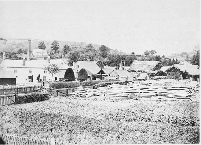
56. The turnery and timber store of James Constance & Sons Ltd, Longhope, in the early 20th century
Oak bark, which figured alongside coppice wood in the tithe customs in 1705, (fn. 379) was a valuable product of the timber crop in Hope wood in 1739. At that time Longhope's woods, Bradley grove among them, were also exploited for the manufacture locally of handles, hoops, and laths (fn. 380) and later they sustained the Constance family's saw mill in the village. (fn. 381) A timber merchant lived in Longhope in 1738 (fn. 382) and members of the Constance family were among resident timber dealers in the mid 19th century. (fn. 383) Woods were also used for raising game and a keeper lived on the west side of May hill in 1861 and 1881. (fn. 384) Shooting rights in Bradley grove were included in 1880 in a tenancy of the adjoining country house (Bradley Court) (fn. 385) and those in Hope wood were let in the early 20th century to Sir Thomas CrawleyBoevey of Flaxley Abbey. (fn. 386) Silver foxes were bred in Bearfoot wood in the 1930s. (fn. 387)
In 1924 Hope wood was one of the Crown woods transferred with the Forest of Dean to the Forestry Commission, (fn. 388) under which it has been managed as part of the Forest (fn. 389) and much of it has been planted with conifers. (fn. 390) Similarly, under the National Trust broadleaf plantations on May hill were replaced with conifers from the 1960s. (fn. 391) The business of James Constance & Sons Ltd continued to own woodland and supply timber in 2006. (fn. 392)
WOODLAND CRAFTS AND SAW MILLS
Longhope's woodland has supported a variety of crafts and trades other than charcoal burning. (fn. 393) In 1608 a cooper, a turner, and two sawyers lived in Longhope (fn. 394) and in the mid 18th century the parish was an important producer of handles for mops, brooms, and rakes, hoops for casks and barrels, and laths, many of the products being sent for sale to Bristol and Bewdley (Worcs.) as well as Gloucester. (fn. 395)
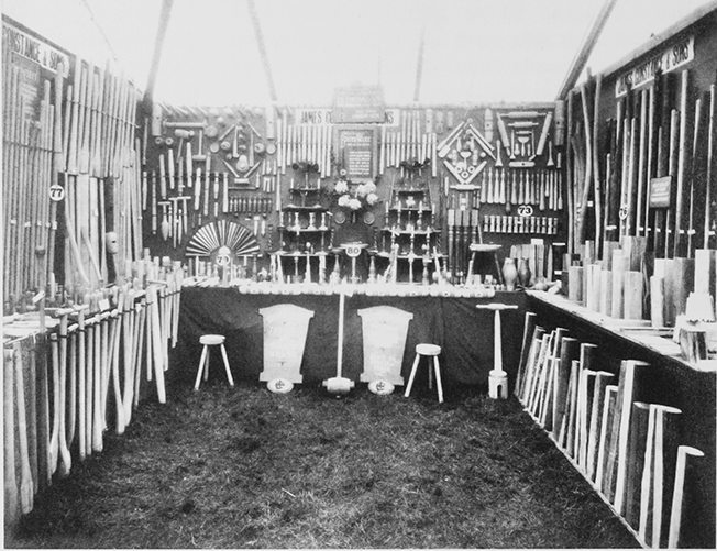
57. Products of James Constance & Sons exhibited at the Royal Agricultural Show, Newport, 1927
Theophilus Constance was a turner at the turn of the century and his son James (d. 1890), (fn. 396) who in 1835 ran the family's workshop by the Longhope brook north of the village centre (in the later Church Road), (fn. 397) had 20 employees in 1851. At that time, when perhaps as many labourers were employed in wood turning and other woodland crafts as in agricultural work, Peter Constance ran a smaller turnery. (fn. 398) Earlier, in 1821, in a short-lived venture Benjamin Constance operated a paper mill in Longhope. (fn. 399) James Constance's business mostly making handles for domestic, garden, and agricultural tools (fn. 400) grew after the opening of the railway. The mill in Church Road was enlarged and at the end of the century, under S.W. Constance, most of its products were for markets outside the county. (fn. 401) Another saw mill operated south of the Monmouth road on the site of a water mill (fn. 402) and hoop and hurdle making continued in the early 20th century next to the railway station. (fn. 403)
The firm of James Constance & Sons, which absorbed a number of smaller local businesses, (fn. 404) increased its workforce in the late 1920s (fn. 405) and, having been sold in the 1940s, employed 40 men and women in the early 1970s. (fn. 406) The mill, which mainly used birch wood, ceased to be a turnery in 1981 and its site was adapted as an industrial estate. (fn. 407) In the 1960s, when a number of other businesses, two of them new in 1953, made ladders and interwoven fencing, (fn. 408) there were saw mills by the Ross road west of Dursley Cross and at Upper End as well as that by the Monmouth road. (fn. 409) A timber merchant had been based at Upper End in the 1920s and 1930s. (fn. 410)
CORN MILLS AND IRONWORKS
Corn mills have operated at a number of sites on the Longhope brook and its main tributary flowing down from Mitcheldean. Several blast furnaces or bloomery hearths situated by the streams in the 17th century probably smelted cinders as well as ore from the Forest of Dean. (fn. 411) One heap of cinders, the refuse of earlier ironworks, was recorded by the Monmouth road in 1726. (fn. 412) Iron making in Longhope ceased in the late 17th or early 18th century and corn milling there ended in the mid 20th century.
Longhope manor had a mill in 1086. (fn. 413) Gilbert of Monmouth (d. 1190) and his wife Bertha charged Longhope mill with the payment of 5s. during Lent to Flaxley abbey for buying wine or repairing books. (fn. 414) The manor's tenants included a millward in the mid 14th century (fn. 415) and the manorial mill, (fn. 416) perhaps that held in the early 16th century by the Dobbs family, (fn. 417) was on the Longhope brook in the south of the parish. A lease of the corn mill passed to the farmer Thomas Daw (d. by 1587) (fn. 418) and a blast furnace, presumably that being built on the earl of Shrewsbury's estate in 1609, (fn. 419) operated next to it in the early 17th century. (fn. 420) The mill, which was still held by the Daw family in the early 18th century, became known as Furnace Mill. (fn. 421) Its operation, as part of the business of the Prince family, was interrupted during local bread riots in 1795. (fn. 422) John Kearsey, the miller in 1841, was also a farmer. (fn. 423) Flour milling ceased there probably in the early 1880s. (fn. 424) Cowman's Mill, downstream, was demolished before 1717. (fn. 425)
A furnace operated higher up the brook just upstream of the Court House (later Court Farm) in 1656. (fn. 426) In 1661 Thomas Nourse, who occasionally used it by agreement with his tenant Thomas Foley, undertook to keep a mill on the stream in constant operation. Paul Foley operated the furnace later, in partnership with his brother Philip from 1674, (fn. 427) and, while there was sufficient power to drive the bellows, shifts of men laboured day and night in 1682. The owner then was Nourse Yate. (fn. 428) The furnace had been demolished by 1717 (fn. 429) but a large pond created by damming the brook existed there in 1777. (fn. 430) A field downstream was known as Dam Meadow, (fn. 431)
At his death in 1608 Nicholas Rowles had a mill on the tributary stream next to Hart's Barn and also a furnace. (fn. 432) The mill, grinding corn, passed as part of the Hart's Barn estate to John Sergeaunt (d. 1615) (fn. 433) and, accommodating two pairs of millstones in the mid 18th century, (fn. 434) was worked as part of the house's farm in the mid 19th century. (fn. 435)
Longhope or Parish Mill, downstream of Hart's Barn by the Monmouth road, (fn. 436) was a corn mill belonging to the parish in the mid 16th century. (fn. 437) In leasing it as part of a small farm to William Yate of Colethrop, in Standish, in 1661 the parish feoffees required him to restore its water supply, which Thomas Weale had diverted to his furnace. (fn. 438) Nathaniel Vaughan worked the mill in the late 18th century. (fn. 439) With two pairs of stones in the late 19th century, it was sold by the parish in the early 1920s (fn. 440) and it finally ceased operating soon after the Second World War. Its machinery remained in place in 1974. (fn. 441)
Elsewhere in 1717 James Sansom, the owner of a freehold called Bird's Mill, held two water corn mills, perhaps two pairs of stones in one building, by copy and William Welch owned another water corn mill, also copyhold. (fn. 442) A mill, perhaps that working in 1780, (fn. 443) possibly stood downstream of Parish Mill at the place south of the Monmouth road where a saw mill worked in the later 19th century. (fn. 444)
In 1850 a flour mill was built on the Ross road at Dursley Cross. (fn. 445) Occupying three storeys and powered by steam, (fn. 446) it closed at the turn of the century; (fn. 447) its machinery, including two pairs of stones, remained in place in 1911. (fn. 448) In the mid 1890s the Palmers, a farming family, operated a steam and water mill elsewhere in Longhope. (fn. 449)
The location of a windmill on one of the lord of the manor's estates in 1569 and 1640 is not known. (fn. 450)
QUARRYING
Longhope's soils, particularly those on May hill, were long dug for lime and marl. (fn. 451) In the 18th century limestone was quarried for building as well as agricultural use (fn. 452) and quarrying on the western slopes of May hill was in many places accompanied by lime burning. In 1735 a quarry and adjacent limekiln belonging to Hunter's (later Rock) farm were reserved by Sir Edmund Probyn, the tenant being allowed to use them for the farm, and in 1757 John Probyn kept a new quarry on the farm with the right to erect another kiln and to remove stone for road repairs and other uses. (fn. 453) In the later 18th century there were also kilns south of the Ross road, one being in the area of Hobb's quarry, (fn. 454) and in the mid 19th century, when twelve men worked at the quarry and kiln on Rock farm, (fn. 455) large quarries were open on both sides of the road, gouging long channels southwards along the limestone outcrop towards the Monmouth road or craters to the north-west, further around the hill. (fn. 456) Several farmers were in business also as stone and lime merchants in the 1870s (fn. 457) and, although many of the quarries and kilns had gone out of use by 1880, Hobb's quarry and several workings below it, all by the line of a long wooded incline running straight down to the Monmouth road, remained open. (fn. 458) Quarrying for road stone continued intermittently into the 20th century, (fn. 459) the main quarries south of the Ross road being reopened by H.A. Pringle in 1919. (fn. 460) In the late 20th century, following their abandonment, sections of those quarries were filled in and landscaped. (fn. 461) In 2005, when cliff faces up to 20 m deep were visible in places, the Gloucestershire Wildlife Trust managed Hobb's quarry as a nature reserve.
The parish also contains small abandoned sandstone quarries in the west. (fn. 462)
OTHER INDUSTRY AND TRADE
A man surnamed Smith (Faber) lived in Longhope in 1221. (fn. 463) Three smiths were listed in Longhope in 1608 among some 24 craftsmen and tradesmen, of whom several pursued other rural trades and woodland crafts and a tanner represented an industry associated with the bark trade. (fn. 464) Tanning took place at several sites in the 17th century. (fn. 465) That used by the Birkin family in the early 18th century (fn. 466) was evidently on the tributary of the Longhope brook by the Monmouth road (fn. 467) and there were tanhouses by the brook itself near Boxbush (fn. 468) and in the village, where a house in Church Road was known in the early 20th century as the Old Tanhouse. (fn. 469) A tannery established by the brook next to Furnace Mill by 1824 (fn. 470) was owned by John Coleman and operated by Frederick Coleman in 1841. (fn. 471) The latter's business, which employed six men and a boy in 1851, (fn. 472) continued until the 1860s. (fn. 473) Weaving was another industry recorded at Longhope in the later 17th century. (fn. 474)
Of 194 families resident in Longhope in 1831 42 depended chiefly on trades or crafts and 109 on agriculture. (fn. 475) A large proportion of the former relied on wood turning and only a small minority of residents was supported by more usual rural crafts. Several masons lived in the parish in the mid 19th century, including Robert Field, whose son Robert (fn. 476) had three employees as a mason in 1871 and whose grandson Frederick Field (fn. 477) (fl. 1939) ran a building business. (fn. 478) A nailmaker lived at Dursley Cross in 1861 and 1889. (fn. 479)
At the end of the First World War a factory for pulping and bottling fruit was built in the village close to the railway station. It closed soon afterwards (fn. 480) and was used as a fruit depot in the early 1950s (fn. 481) and as a welding workshop in 2006. In the later 20th century a number of small businesses were established, some on the site of the former turnery in the village and in the craft centre at Hart's Barn, and in 2006 manufacturers included makers of garden ornaments, furniture, windows and doors, and trailers, handcarts, and trolleys.
The inclusion of three sailors and three carriers among the inhabitants listed in Longhope in 1608 shows that much trade was organised from the parish. Thomas Dobbs's carrying business prospered, (fn. 482) moving goods between London and Abergavenny and Monmouth, and was continued after his death in 1613 by his son Richard (d. 1614). (fn. 483) In the mid 19th century several carrying and haulage businesses operated from the Little London area. One was run by a fruiterer by 1861 (fn. 484) and a farmer provided a regular carrying service to Gloucester in the late 1870s. Although Mitcheldean carriers later offered a regular service to Gloucester, hauliers continued to operate from Longhope. Richard Read, whose father Henry had established a motor transport business in the 1920s, (fn. 485) founded his own haulage firm in 1946 and broadened his business to include the sale of commercial vehicles, building warehouses on a site on the Monmouth road. (fn. 486) In 2006 another haulage firm, started by Richard's brother Harold, operated from Church Road (fn. 487) and the warehouses of a storage and transport business occupied the saw mill site at Upper End.
The railway built along the Longhope valley in the mid 1850s provided some employment, the staff of the village station including a night watchman in 1871. (fn. 488) In the early 20th century several refreshment rooms catered for increasing road and tourist traffic (fn. 489) and in 1927 a garage on the Ross road at Boxbush served motor traffic. (fn. 490) A caravan and camping site established just off the road in the mid 1950s has become a residential park. (fn. 491) For a time there were tea rooms on May hill, on Yartleton Lane. (fn. 492)
Longhope's inhabitants in the mid 19th century included several shopkeepers and a newsman. (fn. 493) There was a postmistress in 1856 (fn. 494) and a second telegraph office, the first being at the railway station, opened in 1897. (fn. 495) In the later 19th century shopkeepers lived in several places, including Dursley Cross, Little London, and Gaston House in Barrel Lane. (fn. 496) A grocery business established at Little London by 1881 (fn. 497) was combined with a bakery for many years and continued after the First World War. (fn. 498) In the late 1930s six shopkeepers, grocers, and bakers were recorded in the parish. (fn. 499) In 2006 the village had the only shop and a post office. In 1969 there had also been a post office on May hill. (fn. 500)
An excise officer lived in Longhope in 1861. (fn. 501) Professional services were provided by Solomon Coleman, who ran his practice as a solicitor from Longhope until his death in 1878. (fn. 502) The professions were also represented by a surgeon in 1906, (fn. 503) at which time a Mitcheldean doctor was the medical officer for the parish. (fn. 504) In 2006 livery and veterinary services were available in Longhope.
LOCAL GOVERNMENT
MANORIAL GOVERNMENT
The manor court provided profits for the lord in the mid 13th century (fn. 505) and was presumably held at the manor house, the site of Court Farm known as the Court House in the early 18th century. (fn. 506) In the late Middle Ages the lord's court for Huntley manor apparently dealt with some tenurial matters in Longhope. (fn. 507) Custom required the Longhope court to meet twice a year (fn. 508) but tenurial business necessitated additional occasional meetings in the 17th century. Of the twice-yearly general sessions as both court leet and court baron that in October, convened in a local inn in the later 1680s and early 1690s, elected a petty constable. (fn. 509) Later the court, which was held until at least 1891, met in general session only in October but continued its occasional sessions. In that period the October court elected two constables until 1841 and a hayward on a few occasions. It dealt with the repair of bridges but its main business until 1874 concerned encroachments on common land, primarily on May hill. In 1842 both the lord of the manor and the vicar were fined for cutting turf on the hill. Fines were also imposed for removing dung from the hill. In the mid 19th century the steward convened the occasional courts in a number of places, often away from Longhope but including the Yew Tree in 1865. (fn. 510)
PAROCHIAL GOVERNMENT
Longhope's two churchwardens, named in 1469, (fn. 511) repaired the parish church, distributed alms, and provided military equipment using the income from parish property held in trust and known later as the Parish Charity Lands. Their role in the trust's business being defined in 1599, (fn. 512) the churchwardens were much involved in later poor relief within the parish and they continued to supply military accessories in the late 17th century. Apart from the trust's contributions, which were divided equally between them, the wardens were funded occasionally from rates and they made separate accounts. (fn. 513)
There were two overseers of the poor long before the 1700s, (fn. 514) each having responsibility for one of the parish's two divisions in which rates were collected separately. Each division also had its own surveyor of the highways. (fn. 515) The burden of poor relief was eased considerably by the Parish Charity Lands trust and from the late 17th century a charity provided funds for apprenticeships arranged by the parish officers, of whom the overseers were partly eclipsed in their work by the churchwardens. Two other charities provided clothing for the poor. (fn. 516) Frequent assistance was given to vagrants and the poor with passes tramping along the main roads. Many of those helped in the mid 1720s were sailors. From the mid 18th century poor residents were sometimes treated in the Gloucester infirmary. A local workhouse, the articles of which were signed in 1774, (fn. 517) had closed by 1803. (fn. 518) In 1811 the vestry agreed an ex gratia payment of £10 to a labourer, who after being chosen by ballot to serve in the militia had hired a substitute to save his family from becoming dependent on the parish. Another workhouse opened after 1816 was in use in 1835 (fn. 519) when Longhope became part of the new Westbury-on-Severn poor-law union. (fn. 520)
The rise in the cost of relief in the later 18th century was marked and in 1803, when 22 parishioners received regular and 12 occasional help, Longhope supported 63 outsiders, presumably squatters living on May hill among them. The cost, £222, was double that twenty years earlier, but included £16 spent trying to recover money paid to the hundred's high constable. (fn. 521) Ten years later, when the trust funded expenditure only in the parish's upper division, the poor were even more numerous and £638 was used to help 129 people, 66 of them permanently; in 1815 £287 was spent on a similar number of people. (fn. 522) The cost of relief remained over £220 in the 1820s and 1830s and was almost £350 in the early 1830s. (fn. 523) The parish employed a salaried assistant overseer after 1835 (fn. 524) and the Parish Charity Lands trust, although it ceased to pay house rents, (fn. 525) made an appreciable contribution to the business of relief well into the 20th century. (fn. 526)
Longhope, with its two main roads, was presented in 1598 for letting the Monmouth road fall into disrepair (fn. 527) and was fined in 1682 for not repairing its highways. (fn. 528) Road maintenance remained a considerable financial burden in the turnpike era, particularly for the parish's upper division which included the Ross road, (fn. 529) and on occasions was financed by fines on the whole parish. (fn. 530) After assuming responsibility for the turnpike roads in 1880 the two surveyors each received a salary but from 1886 the vestry employed a single surveyor for the two divisions, reducing his salary in 1889 after the county council took over the main roads. (fn. 531)
The vestry remained at the forefront of parish government until the election of a parish council in 1894. (fn. 532) The council, which immediately became embroiled in the affairs of the trustees of the Parish Charity Lands, (fn. 533) had regular meetings to deal with its own business, including the appointment of parish officers and the oversight of public rights of way and springs, and the assistant overseer usually acted as its clerk. In 1898 the council took over the management of the summit of May hill, (fn. 534) which had been the responsibility of the churchwardens and overseers since 1874, (fn. 535) and from 1900 it paid a groundsman to look after the land and its clump of trees. It also took over the running of some allotment gardens and in 1901 it succeeded the lord of the manor in maintaining the parish pound and appointing the hayward. In 1906 it moved its regular business meetings from the British schoolroom on Hope's hill to the Latchen Room (the village hall), (fn. 536) which it bought in 1924. (fn. 537)
Longhope had a number of police stations in succession. (fn. 538) The earliest recorded was accommodated in the former vicarage house in 1899. (fn. 539)
SOCIAL HISTORY
SOCIAL STRUCTURE
In the later 13th century customary tenants on Longhope manor owed cash rents and five cottagers and two mondaymen were among those with smaller holdings. (fn. 540) Fifty-four people were assessed for tax in Longhope and Blaisdon in 1327, two, including Sarah Talbot, for just over 6s. and five, among them the two lords of Blaisdon manor, for between 4s. and 4s. 8d. Eleven people were taxed for 2s., two for 1s. 6d., twenty-three for 1s., one for 9d., and ten for 6d. (fn. 541) Despite Sarah Talbot's inclusion in the assessment, the Talbots, lords of Longhope manor and later earls of Shrewsbury, (fn. 542) were invariably non-resident.
Few wealthy people lived in Longhope. In 1522 of fifty-five men other than the vicar one (William Dobbs) had goods valued at £20, two at £10, and two at £8. Of the rest the great majority had goods worth £3 or less and for eight parishioners no valuation was provided. (fn. 543) In 1608 three residents, Henry Acton, Arthur Rowles, and John Bower, were described as gentlemen. Among the rest, a community of small farmers, craftsmen, tradesmen, and cottagers, the carrier Thomas Dobbs employed two of the eight men described as servants. (fn. 544) In 1672, when 48 of 115 residents were excused the payment of hearth tax, the great majority of parishioners had a single hearth and 23 including the vicar two hearths. Nine householders each had 3 hearths, two 4 hearths, and one (Thomas Master) 5 hearths. (fn. 545) The farmer Thomas Bright, one of the resident manorial bailiffs in the mid 17th century, was reputed to be well over 110 years old at his death in 1708. (fn. 546) Among the leading local landowners Thomas Nourse (d. 1675) and his successor Nourse Yate (fn. 547) made substantial donations to the church and the poor. (fn. 548)
In 1769 the parishioners needed to defray much of the cost of rebuilding the church by soliciting funds from elsewhere. (fn. 549) In the later 18th and early 19th century the number of cottagers increased as squatters settled on the commons below the summit of May hill to live off the local woods (fn. 550) and the burden of poor relief rose considerably. (fn. 551) During local bread riots in 1795 Foresters intercepted wheat destined for a flour mill in Longhope and demonstrated at the mill. (fn. 552) In 1814 a small farm at Lonehead formerly owned by John Stephens, a master mariner, belonged to Duncan Thompson Stephens, his son by Mary Thompson, a free quadroon woman living in Jamaica. Duncan, who had been in England, had returned to Jamaica as a saddler and on his death there in 1821 the land passed to his father's legitimate heirs. (fn. 553)
John Probyn, rector of Abenhall and archdeacon (later dean) of Llandaff, moved to Longhope about the time he inherited the manor in 1819 (fn. 554) and made the Manor House his home. (fn. 555) On the death of his brother William in 1825 he gave the vicarage to his son-in-law Charles Mein Dighton and, after Charles's premature death, in turn to his son Edmund Probyn (d. 1837) and son-in-law Robert Napier Raikes (d. 1851). (fn. 556) John's son and heir John also lived in Longhope, patronizing local societies and groups. (fn. 557) In 1851 his household included six servants and his sisters Caroline Raikes and Elizabeth Probyn maintained smaller establishments at the vicarage and the Temple. Several other parishioners, including the landowner John Coleman, the curate, the Baptist minister, and ten farmers, also employed domestic servants. The adult male population was mostly tradesmen, craftsmen, and manual workers, with a handful of businessmen headed by the wood turner James Constance and many of the farmers being employers of labour. (fn. 558) While the solicitor Solomon Coleman (d. 1878) lived permanently in Longhope, (fn. 559) members of the professions were usually a transient presence, Jordan House being home to a barrister in 1851 and a clergyman in 1861. (fn. 560)
Although Elizabeth Probyn lived in Longhope until her death in 1897, (fn. 561) after John Probyn's death in 1863 the lord of the manor was again non-resident, Edmund Probyn living in Huntley before moving to Staffordshire. (fn. 562) In the later 19th century the Manor House was occupied by a succession of tenants and the number of private residents increased as incomers moved into houses in the village and on May hill. Widows and spinsters headed a number of households, (fn. 563) the largest of which was at Bradley Grove (later Bradley Court), built in the late 1860s for the colliery owner Osman Barrett (fn. 564) and from 1880 the home of the family of Thomas Miller (d. 1882), formerly a merchant in the Cape Verde Islands. (fn. 565) During that period the vicar F.C. Guise, a member of a leading county family, chaired much parish business until the eve of the first election, in 1894, of a parish council. (fn. 566)
H.A. Pringle, who took a lease of the Manor House in 1916 before becoming the main landowner in Longhope, (fn. 567) was among several military officers to move to Longhope at that time. W.S. Davis, who settled at Coglan House, (fn. 568) was formerly of the Indian civil service. His son Admiral Sir William Davis (d. 1987) took a leading part in youth and other organizations within the county. (fn. 569) Among local businessmen representing the parish in local government were the timber merchant William Constance, elected as vice-chairman of the rural district council in 1918, (fn. 570) and the baker and grocer William Armstrong Bradley (d. 1939), a member of the district council for over 20 years after his retirement. (fn. 571) New building in the later 20th century, particularly the development of a housing estate on the edge of the village after 1971, drew many new families into Longhope and retired people made up a quarter of the households in the village at the end of the century. (fn. 572) Several of the larger houses in the parish, including the Manor House, the Temple, and Bradley Court, were turned into hotels or nursing homes, a process under way by the mid 20th century. (fn. 573)
CHARITIES FOR THE POOR
A charitable trust used land and cottages acquired by the parish from a series of gifts beginning in the late 14th century (fn. 574) to finance repairs to the parish church, equipment for soldiers, and help for poor and orphaned parishioners, maimed soldiers, and prisoners in the county gaol. The body of feoffees, in which the property was vested, renewed itself by the grant of its two surviving members in the mid 16th century. Rules imposed in 1599, after improper handling of trust affairs, set the minimum number of feoffees at 12 and required the churchwardens and at least six other parishioners to approve leases of trust property, which comprised scattered pieces in Longhope and a share in a cottage in Mitcheldean. (fn. 575) The feoffees' body regularly renewed itself from that time and the trust became known as the Parish Charity Lands. (fn. 576) In spending the income of the trust the churchwardens were much involved in poor relief and in the late 17th and early 18th century, when the rental was usually just over £35, they made cash payments typically of 6d. to soldiers and sailors as well as to parishioners. (fn. 577)
The amount regularly available to the churchwardens for Longhope's poor was increased by legacies from Thomas Nourse, who by will proved 1675 left £5 a year for coats or other garments for 10 people at Christmas and £5 a year for apprenticeships for one or two children in London, Bristol, Gloucester, or a market town. The payments, as charges on the rectory estate, (fn. 578) were from Nourse Yate until 1701 and from the vicar thereafter (fn. 579) and the apprenticeships were arranged, usually one a year, in London and elsewhere. In 1695, while churchwarden, Nourse Yate supplemented the premium paid to a Coleford tailor. (fn. 580) To enable eight elderly people to have shirts at Christmas, farmer Thomas Hodges by will proved 1736 left a piece of land called Broom's Pool for buying linen cloth in the great market held at Ross-on-Wye after Michaelmas. (fn. 581) By the mid 1820s, when that land produced a rent of £4, (fn. 582) Thomas Nourse's clothing charity was restricted to five people, the same ones receiving it every other year, and his apprenticeship charity funded a new apprenticeship every two or three years. (fn. 583)
Apart from the repair of its buildings and the church, the Parish Charity Lands used its income of between £130 and £140 in the mid 1820s for the poor. (fn. 584) After the demolition of the Mitcheldean cottage and until 1865 the trust received 25s. a year from Mitcheldean parish. (fn. 585) Under rules agreed in 1835 the trustees (formerly feoffees) appointed a treasurer and started holding quarterly meetings. Those meetings were frequently adjourned because a quorum of three was not present and from 1843 the vicar and churchwardens were co-opted as acting trustees with responsibility for much of the administration. In 1844, with payments to the poor an almost daily event, a salaried relieving officer (later almoner) was employed (fn. 586) and the dispensing of the clothing and apprenticeship charities passed from the treasurer back to the churchwardens. (fn. 587) At that time those charities provided coats for five men and clothing material including duck and calico for over 30 men and women at Christmas. The occasional apprenticeships were served by boys locally but usually outside the parish. (fn. 588) Thomas Nourse's clothing charity provided three coats and cloth for men's frocks from 1858 (fn. 589) and together with the Hodges charity supplied, in addition to the coats, cloth to 43 people in 1875 and 50 people in 1890. (fn. 590) Under a Scheme of 1913 the apprenticing charity could give cash support for Longhope children in apprenticeships in market towns more than 15 miles away. (fn. 591)
From 1866, under a Scheme which established the vicar and churchwardens among its governors, the Parish Charity Lands applied its substantial income in equal parts to the church, the church school, and the poor. (fn. 592) For the poor its almoner made individual weekly and occasional cash payments with freeholders ineligible for poor-law relief being favoured for regular help. Weekly pay was raised from 2s. to 2s. 6d. in 1906, when there were four recipients, and was according to need from 1909, following the introduction of State old-age pensions. In 1913 the trust assigned part of its subscription to the Gloucester infirmary to a local nursing association. (fn. 593) From 1896 a third of the trust's income was reserved for the maintenance of the parish church and the rest was used for the school and the poor by a separate charity with representatives of the parish council on its board. (fn. 594) Distinct from the trust property was a piece of woodland (6 a.) held for charitable purposes in the mid 19th century (fn. 595) and an acre on May hill near Dursley Cross set aside by the Inclosure Commissioners in 1874 for the benefit of the parish's labouring poor. (fn. 596) Rose Barton by will dated 1951 left £1,000 for a Christmas party for the poor and infirm. (fn. 597)
From 1957 the Parish Charity Lands trust, which had sold its land, (fn. 598) could apply a third of its income to the poor, another third to the church fabric, and the final third to the poor or church repairs as thought fit. In practice only a third went to the church and under the new Scheme 13 mostly elderly people received weekly pensions of 5s., paid monthly, in 1969. In 1976 the Nourse and Hodges clothing charities and the charity for the labouring poor were merged to form the Longhope Relief in Need charity providing individual and general help. The new charity's income was augmented by a third of that of the Parish Charity Lands, which was also allowed to give another third to the Nourse apprenticeship charity for education and training purposes. Administered together under the title of the Longhope Parish charities (fn. 599) the three charities altogether spent £1,799 in 2005. The Christmas party charity remained separate under the name of the Rose Barton and Margaret Skelton charity. (fn. 600)
EDUCATION
Longhope had a public school in 1679. (fn. 601) A schoolmaster lived there in 1803 (fn. 602) but in 1818, while there was a Sunday school, there was no day school for the poor. (fn. 603) Edmund Probyn, who built a schoolroom next to his new vicarage house in the late 1820s, (fn. 604) employed a teacher with 63 day pupils paying pence in 1833. At that time 185 children attended the Sunday school. (fn. 605) In 1836 Edward Goff's (or Gough's) trust appointed a master for a day school at the Baptist chapel at Little London. The master and his successor also served as the chapel's minister (fn. 606) and from 1846 the free day school and a Sunday school were taught in the meeting's new chapel on Hope's hill. (fn. 607) At that time there were also two small dame schools in the parish. (fn. 608) A school for boys from a wealthier background, opened by John Irving at Blenheim House, Lea Line, by 1841, had 33 boarding pupils in 1851. (fn. 609)
At the vicarage schoolroom, where over 100 children attended Sunday school in the mid 1840s, (fn. 610) Revd F.C. Guise ran a day school attended on average in the early 1860s by c.68 children including infants. Known as Longhope Church of England school, it was funded in part by annual sermons (fn. 611) and from 1866 it received a third of the income of the Parish Charity Lands trust. (fn. 612) It was also supported by pence and voluntary contributions and in 1874 the average attendance was 50. (fn. 613)
The Baptist chapel on Hope's hill had a schoolroom in 1855 and its Sunday school taught 119 children in 1866. (fn. 614) A new schoolroom was added to the chapel in 1866. The day school, supported by pence and receiving £50 a year from Goff's trust for the teacher's salary, taught boys, girls, and infants and had an average attendance of 40 in 1874, when it became a British school (fn. 615) with the minister as the chief manager and its first female teacher was appointed. (fn. 616) The boarding school at Lea Line closed in the 1870s. (fn. 617) Among later, smaller schools one at Upper End for girls, established by 1891, (fn. 618) remained open in 1916. (fn. 619)
The church and the British schools respectively had average attendances of 52 and 40 in 1885 (fn. 620) and 60 and 69 in 1904. (fn. 621) The British school, which was enlarged in 1893 to provide separate infant accommodation, (fn. 622) became known as Longhope Council school on its transfer to the county council in 1906 (fn. 623) and the average attendance in 1910 was 86 in mixed and infant departments. (fn. 624) The church school, with an average attendance of 55 in 1910, (fn. 625) was altered and given a new playground to its west in 1911 (fn. 626) and had in mixed and infant departments an average attendance of 46 in 1922 and 43 in 1938. (fn. 627) There were 78 children on its roll in 2000. (fn. 628) The council school, where average attendance declined from 67 in 1922 to 49 in 1938, (fn. 629) was known as Hopes Hill Community Primary school and had 40 children, some from Blaisdon, on its roll in 2000. (fn. 630) In 2001 the two schools were amalgamated to form Hope Brook C. of E. Primary school, which moved in 2003 to a new building in the centre of the village off Church Road. (fn. 631) It had 110 children on its roll at the beginning of 2005. (fn. 632)
An agricultural college established at Bradley Court in the early 20th century was superseded by a riding school in the later 1930s. (fn. 633)
SOCIAL LIFE
Morris men have long gathered on the summit of May hill to greet the dawn of May Day. (fn. 634) The ancient custom was for men from surrounding parishes to enact in mock battle a contest, originally between the forces of winter and spring, for possession of the hill. (fn. 635) In 1875 a morris dance ended workmen's celebrations for the construction of the top part of Yartleton Lane. (fn. 636)
The Yew Tree inn, standing west of the village on the Monmouth road, had evidently opened by 1608. (fn. 637) In the 1660s Longhope had three unlicensed alehouses. (fn. 638) At least one of them was open in the mid 1680s (fn. 639) and the manor court met at a local inn in 1688 and 1692. (fn. 640) A house below Bradley grove was known as the Bear in 1717 (fn. 641) and the parish also had houses called the Leather Bottle in 1736 (fn. 642) and the Cock in 1743. (fn. 643) A victualler lived at Dursley Cross in 1727. (fn. 644)
In the village a public house on the Monmouth road was known as the Plough by 1856 (fn. 645) and there were beerhouses next to the railway station and in the Latchen in 1861. Little London had the King's Head inn in 1861. (fn. 646) An inn at Dursley Cross recorded in 1830 (fn. 647) was known as the Eight Bells in 1841 (fn. 648) and beerhouses further along the Ross road were known as the Farmer's Boy and the Nag's Head in 1851 and 1871 respectively. (fn. 649) Of the five public houses licensed in Longhope in the late 19th century (fn. 650) that at Dursley Cross closed in the mid 20th century (fn. 651) and the Plough was demolished in the mid 1970s. The Yew Tree, Nag's Head, and Farmer's Boy served Longhope and passing traffic in 2005.
The Yew Tree was the meeting place of a friendly society formed in 1845. (fn. 652) Later societies met there or at the Plough, one having 39 members at its dissolution in 1881. (fn. 653) A friendly society based on the Cross inn on May hill in 1864 had 37 members when it was wound up in 1884. (fn. 654) In the mid 19th century local festivals and annual treats occasionally enlivened social life. Such events usually followed a service in the parish church or the Baptist chapel and were accompanied by sports and marked by processions which, as in 1855 during the Crimean War, afforded displays of patriotism. (fn. 655)
From the mid 19th century parish business was generally conducted in the schoolroom near the church. (fn. 656) In 1895 the new parish council chose to do its business in the schoolroom at the Baptist chapel (fn. 657) and from 1906 it met at the Latchen Room, a new hall built for the parish at the bottom of the village on the Monmouth road by William Henry Powell of Hill House. (fn. 658) A hall was built at the chapel in 1922. (fn. 659) The Latchen Room accommodated a variety of clubs and societies including a branch of the Women's Institute recorded in 1923 and a drama society formed in the early 1930s and has remained the village hall. Longhope also had a band and a branch of the British Legion in the late 1930s (fn. 660) and local groups in 2005 included a gardening club as well as the drama society and the Women's Institute. A hall erected in the parsonage grounds near the church in the mid 20th century (fn. 661) has been demolished to make way for a small housing estate.
A football club made the Latchen Room its headquarters in 1906. (fn. 662) A cricket club was founded soon afterwards (fn. 663) and a bowling club existed in the late 1930s. (fn. 664) Blacksmith's Meadow, just north of the village centre, was made a recreation ground on its purchase by public subscription in 1947 as a memorial to local men killed in the Second World War. (fn. 665) It continues to be used by football, cricket, and tennis clubs.
A medical officer appointed in 1883 provided services from Mitcheldean (fn. 666) and in 1939 one of two visiting physicians held a surgery in Longhope twice a week. (fn. 667) A nursing association was formed for Longhope and Blaisdon in 1907. (fn. 668)
RELIGIOUS HISTORY
EARLY HISTORY AND STATUS OF THE PARISH CHURCH
The church at Longhope, to which that at Huntley was a chapel in the mid 12th century, was given to Monmouth priory presumably in William I's reign by the priory's founder Wihanoc of Monmouth. (fn. 669) The priory appropriated the church (fn. 670) and a vicarage had been established by 1291. (fn. 671) The impropriate rectory, which included the tithes of the parish, was added to the vicarage's endowments in the early 18th century (fn. 672) and the style of the benefice changed from vicarage to rectory in the late 19th century. (fn. 673) The benefice was united with Huntley with May Hill in 1983 and the united benefice included Churcham and Bulley from 2003. (fn. 674)
PATRONAGE AND ENDOWMENT
Until the Dissolution the vicarage was in the gift of Monmouth priory. (fn. 675) The Crown presented to the living in 1340, when the priory, a cell of the abbey of St Florent at Saumur (Maine-et-Loire), was in the king's hands by reason of war with France, (fn. 676) and in 1391. (fn. 677) Following the Dissolution the patronage passed with the rectory, (fn. 678) with Raphael Rawlins of Gloucester being patron at the first vacancy, in 1541, under a grant from the priory (fn. 679) and the Crown being patron for a turn in 1626. (fn. 680) On giving the rectory to the vicarage in 1701 Nourse Yate reserved the patronage (fn. 681) and in 1703 Joseph Venn was patron for a turn. (fn. 682)
After Yate's death the patronage descended with his Longhope estate (fn. 683) to his granddaughter Priscilla Bromwich. In 1774 she and William Matthews presented David Jones, (fn. 684) and he acquired the patronage shortly afterwards. (fn. 685) After Edmund Probyn bought it, probably in 1783, (fn. 686) it descended with the manor until the later 1840s. (fn. 687) From Sir John Wright Guise Bt, patron in 1851, (fn. 688) it passed to his son and heir Sir William Vernon Guise, and by 1879 it was apparently vested in the widow of Vernon George Guise (d. 1861), a former vicar of Longhope. (fn. 689) After belonging to F. Burrow of Cullompton (Devon) in 1894, it was acquired by J.C. Sharpe and after his death in 1913 it passed to the National Church League. (fn. 690) The Church Society was successor to the league (fn. 691) but the bishop became sole patron of the benefice of Huntley with May Hill and Longhope created in 1983 and shared the patronage with the dean and chapter of Gloucester after Churcham and Bulley were merged with the united benefice in 2003. (fn. 692)
Longhope vicarage, valued at £4 in 1291, (fn. 693) had a house in the early 15th century. (fn. 694) It included a lease of the rectory tithes in 1535, when it was worth £9 7s. 11½d. clear, (fn. 695) and in the 1540s Thomas Baker claimed its glebe and house to be his as rector. (fn. 696) The vicarage was worth £30 a year in 1650. (fn. 697)
Thomas Nourse by will proved 1675 left £10 a year from the rectory to future resident vicars (fn. 698) but his successor Nourse Yate, on adding the tithes with the rectory to the vicarage's endowments in 1701, ensured that the annuity was paid to George Venn, the vicar of Sherborne, until he became vicar of Longhope in 1703. (fn. 699) Payments of tithes in kind (fn. 700) had largely ceased by 1719 but some of fruit remained in kind and those of wood continued in kind under the agreements for cash rents tithe payers negotiated with a new vicar in 1774 and 1775. (fn. 701) In 1825 a new vicarage house was begun near the church (fn. 702) and in 1829 part of the glebe, including the old house, was exchanged for land adjoining the new house and containing a new schoolroom. (fn. 703) The vicar was awarded a corn rent charge of £403 3s. for the tithes in 1841 (fn. 704) and the living, which had been worth £120 in 1750, (fn. 705) was valued at £394 in 1856. (fn. 706) Most of the glebe, which contained 23 a. in the mid 19th century, (fn. 707) was sold in the 1920s (fn. 708) and another part in the late 1940s. (fn. 709) The house was sold in the late 20th century.
RELIGIOUS LIFE
The Middle Ages
Longhope's church, which was dedicated to All Saints by the mid 12th century, (fn. 710) was built perhaps in the late 11th century and comprised chancel, nave, and west tower, all with walls of thin-bedded sandstone rubble and dark red quoins, perhaps from Mitcheldean. The nave retains single-light windows (blocked) with monolithic heads and the original tower, which had pilaster buttresses, survives up to the first string course. The chancel was extended in the 13th century and its medieval fabric, re-used in major repairs in the early 1770s, (fn. 711) includes two lancet windows (one blocked) and a south door. North and south transeptal chapels, about equal in length and with matching double-chamfered arches towards the nave, were built and traceried windows inserted in the south side of the nave, all probably in the early 14th century. Probably about the same time an octagonal spire was placed on the tower (fn. 712) and a new tower arch created. A south porch was added later, as were some nave windows in Perpendicular style. (fn. 713) A series of gifts of lands to the parish from the late 14th century provided funds for the maintenance of the church and other purposes in the mid 16th century and became known as the Parish Charity Lands. (fn. 714)
The earliest known vicar of Longhope is Nicholas of Tibberton in 1318. (fn. 715) Geoffrey Marshall, who became vicar in 1340 (fn. 716) and possibly retained the living in 1390, (fn. 717) was from a local landowning family. (fn. 718) John Sabyn, a parishioner who took orders as an acolyte in 1349, (fn. 719) became vicar in 1391 and was allowed to occupy the main part of the vicarage's hall on his retirement in 1419. (fn. 720) The next two incumbencies spanned over a century. (fn. 721)
From the Reformation to the Restoration
William Trigge, vicar from 1541, (fn. 722) was fully knowledgeable on the Lord's Prayer but unable to recite the Ten Commandments and adduce scriptural authority for the Apostles' Creed in 1551. (fn. 723) He was deprived of the living early in Mary's reign. Before that, in 1548, the parish sold a chalice, a pyx, and a cross to fund equipment for soldiers in the army and repairs to the highway to Huntley. (fn. 724) Among the church's acquisitions was a copy of Foxe's Book of Martyrs. (fn. 725)
Henry Deyce, vicar from 1561, was a poor Latinist (fn. 726) and was reported in 1576 for providing only one sermon in the previous year, allowing another man to deliver the communion cup, not teaching the catechism, wearing a surplice on perambulations, and churching unmarried women. (fn. 727) Although not considered a preacher, Thomas Rudge, (fn. 728) vicar 1577–1618, (fn. 729) preached regularly in the church and instructed children in the catechism. During his time a parish clerk was unable to read lessons and psalms publicly and a few families were negligent in attending church. (fn. 730) Edward Potter, vicar from 1626, was the rector of Abenhall. Deprived of both livings, he was succeeded at Longhope in 1656 by Thomas Smith. (fn. 731)
The Established Church and Nonconformity after the Restoration
After the Restoration Smith was ejected from the vicarage and was succeeded by George Ditton in 1664. (fn. 732) It was possibly in that period when a large mortar was installed in the church for use as a font in place of one destroyed before the Restoration. (fn. 733) Smith remained in Longhope, ministering in his own house (fn. 734) until at least 1672 when it was licensed for Congregational meetings. Longhope also had a Presbyterian meeting in 1672. (fn. 735) Although no dissenters were recorded in the parish in 1676, (fn. 736) perhaps a score of people regularly absented themselves from church at that time (fn. 737) and a house was registered for worship by Presbyterians in 1710. (fn. 738)
George Ditton, whom Thomas Nourse expressly excluded from enjoyment of the annuity he left for future vicars, (fn. 739) remained vicar until his death in 1700. (fn. 740) The annuity, intended to ensure that Longhope was served by an able and orthodox preaching minister, was denied also to Charles Hopkins, Ditton's successor, and lapsed in 1703 when George Venn succeeded Hopkins and resigned the living of Sherborne. (fn. 741) In Venn's early years at Longhope Bibles, prayer books, and religious literature were occasionally presented to a handful of children and adults. (fn. 742)
In 1695 in work commissioned, and partly paid for, by churchwarden Nourse Yate a new painting of the king's arms and new tables displaying the Lord's Prayer, the Creed and the Ten Commandments were installed in the church. At the same time the church's copy of Foxe's Book of Martyrs was bound. (fn. 743) The church's bells, numbering four in 1680, (fn. 744) were replaced by a ring, probably of five, cast in 1700 by Abraham Rudhall. (fn. 745)
Church and Chapel after 1715
Thomas Mantle, vicar from 1718, was also rector of Abenhall from 1723. (fn. 746) In 1742 the patrons, the Yate sisters, gave the vicarage to Yate Bromwich, the son of one of them. Bromwich, who was instituted as vicar anew in 1754, inherited the sisters' estate in Longhope in 1763 and remained vicar until his death in 1774, employing his son William as his curate from 1769. (fn. 747) From 1786, and until 1851, all the vicars were members and relatives of the Probyn family. William Probyn (1786–1825) became vicar of Pershore (Worcs.) in 1797 and from there employed a curate at Longhope. (fn. 748)
The church, in which a parishioner gained permission in 1716 to erect an additional private pew, had a damaged ceiling in 1730. (fn. 749) Despite occasional repairs the building's condition deteriorated further and part of its roof collapsed. The ceiling and some fittings were removed early in 1769 and extensive repairs were carried out in 1770 and 1771 under the supervision of local craftsmen. During that work, for which deals were brought from Bristol, the tower and steeple were repaired and parts of the church, including the chancel, were entirely rebuilt. Among the fittings introduced were new seats and a replacement table of the Articles. (fn. 750) A gallery recorded later was probably at the west end. (fn. 751) In later work the spire was partially rebuilt in 1808 (fn. 752) and the tenor bell recast in 1829. (fn. 753)
Seventeen Independents recorded in the parish in 1735 (fn. 754) were presumably members of the nonconformist church in Mitcheldean, which in the later 18th century counted deacon Nathaniel Vaughan among its Longhope adherents. (fn. 755) In 1799 under Stephen Philipps, its acting pastor, the Mitcheldean meeting registered a house at Little London for worship. (fn. 756) Another group had a new chapel in Longhope in 1807 and a congregation established in 1823 by G.B. Drayton, minister of the Baptist church in Gloucester, built a meeting house at Little London. That chapel, registered in 1824, (fn. 757) used a nearby stream as its baptistery and from 1836 it had a resident minister and schoolmaster. (fn. 758) There was also a meeting of Wesleyans in Longhope in 1825 (fn. 759) and John Horlick, minister of the Mitcheldean Independent church, registered a farmhouse there in 1829. (fn. 760)
In 1825, when Charles Mein Dighton became vicar, the average congregation at the parish church, which then had few free sittings, was said to be 250, the number of communicants was put at 30, and between 70 and 80 children received religious instruction from the church on Sundays. Sunday services, in which psalms and anthems were sung, were reduced during the winter from two to one, conducted in the morning and afternoon alternately. Dighton started building a new vicarage house but fell ill and died not long after leaving Longhope for Madeira in 1826. (fn. 761) His successor Edmund Probyn (d. 1837) became rector of Abenhall at the same time and lived at Longhope until 1834. (fn. 762)
The Reign of Victoria (1837–1901)
Robert Napier Raikes, vicar from 1837, remained resident after acquiring the living of Old Sodbury with Chipping Sodbury soon afterwards. (fn. 763) The Baptist chapel at Little London had been abandoned by 1844 when the home of its minister Henry Clement Davies, within Blaisdon, was licensed for services. (fn. 764) In 1846 the meeting opened a new chapel called Zion built with financial help from John Probyn and other Anglicans on land on Hope's hill donated by James Constance, a farmer. (fn. 765) Although a Wesleyan minister registered John Constance's house in 1840, the later story of Methodism in Longhope is not recorded. (fn. 766) A house on the Monmouth road towards Mitcheldean was later known as the Old Chapel. (fn. 767)
In 1850 congregations at the parish church then with 350 sittings, 210 of them free, were small but were said to have increased recently under a curate, nearly doubling to 70 in the morning and 120 in the afternoon. In 1851 the Easter Sunday congregations were 198 in the morning and 100 in the afternoon. (fn. 768) At the Baptist chapel, which had 130 sittings, all free, the congregations on the same day were 71 in the morning, 84 in the afternoon, and 102 in the evening, (fn. 769) some of those present being from outside Longhope. (fn. 770) A new schoolroom was added to the chapel in 1866 (fn. 771) and the meeting, which had 36 members in 1868, (fn. 772) continued to have a resident minister. (fn. 773)
Vernon George Guise, who became vicar later in 1851, and his cousin Frederick Charles Guise, who succeeded him in 1861, (fn. 774) both served in person. (fn. 775) The church, much of the outside of which had been coated in yellow stucco, (fn. 776) was extensively restored from 1858 to designs in 13th-century style by the Gloucester firm of Medland & Maberly. In replacing windows and many other post-Reformation changes those architects remade a chancel arch, took down the gallery, and unblocked the tower arch. They also added a north vestry and organ loft and included a stone pulpit and font among the new fittings. (fn. 777) In 1869, on the advice of A.W. Maberly, the spire was removed and the tower was buttressed and its upper stages rebuilt with crocketed angle pinnacles and battlements and a cusped west window. A screen was placed in the tower arch and the five bells were repaired in 1870. (fn. 778) V.G. Guise (d. 1861) was commemorated in new glass in the chancel east window. (fn. 779) Much of the restoration work was funded by the Parish Charity Lands trust. Church rates had ceased to be collected in 1861. (fn. 780)
There were further alterations to the parish church in the later 19th century and it was cleaned and redecorated in 1889, with Revd F.C. Guise paying a third of the cost of the renovation of the chancel. A repair of the tower was funded in 1891 mainly by subscriptions. (fn. 781) A new organ was installed in 1893 (fn. 782) and an oak lectern was carved, depicting an angel, and given to the church by R.S. Kearsey, a churchwarden, in 1897. (fn. 783)
The Twentieth Century and Later
The church continued to be served by a resident incumbent after F.C. Guise's resignation of the living in 1896. George Barr, his immediate successor, (fn. 784) remained rector until 1916 (fn. 785) and there was a mission room at the Upper End in 1901. (fn. 786) Bible classes and lectures were held in the Latchen Room after 1906 (fn. 787) and funds collected for a church institute were used in 1910 to build a vestry and purchase surplices and cassocks for the church choir. (fn. 788) In 1912 the organ was enlarged at the expense of Constance Miller, (fn. 789) whose family had lived at Bradley Court (formerly Bradley Grove), (fn. 790) and a weekly collection to increase the organist's salary began. (fn. 791) Members of the Miller family are commemorated in glass fitted in the chancel south window in 1911. (fn. 792) Barr, who himself spent the moneys collected at early morning services and the first main Sunday service of each month on the church and the poor, purchased a silver flagon in 1915 and a paten in 1916. (fn. 793) The church plate had included a chalice and paten made in 1898. (fn. 794) In 1922 a sixth bell was added to the church's peal. (fn. 795)
Successive rectors in the mid 20th century resided and served in person (fn. 796) but after Longhope ceased to be a benefice on its own in 1983 its church was served from Huntley. (fn. 797) Church repairs continued to receive funds from the Parish Charity Lands trust (fn. 798) and in work completed in 1987 the peal of bells was increased from six to eight, a ringing chamber was inserted in the tower and a kitchen installed in its base, and the windows in the nave and the south transept were restored. (fn. 799) From 2003 the church was part of a ministry including four other churches (fn. 800) and in 2005 it had at least one service every Sunday. The Baptist chapel on Hope's hill, where the adjoining elementary school closed in 2001, (fn. 801) had a resident minister in 2005. The mission room at the Upper End stood long abandoned in 2005. Roman Catholics attended services at the Salesian Society's school established in Blaisdon in the mid 1930s. (fn. 802)