A History of the County of Gloucester: Volume 12. Originally published by Boydell & Brewer for Victoria County History, Woodbridge, 2010.
This free content was digitised by double rekeying. All rights reserved.
'Pauntley', in A History of the County of Gloucester: Volume 12, ed. A.R.J. Jurica (Woodbridge, 2010), British History Online https://www.british-history.ac.uk/vch/glos/vol12/281-301 [accessed 30 April 2025].
'Pauntley', in A History of the County of Gloucester: Volume 12. Edited by A.R.J. Jurica (Woodbridge, 2010), British History Online, accessed April 30, 2025, https://www.british-history.ac.uk/vch/glos/vol12/281-301.
"Pauntley". A History of the County of Gloucester: Volume 12. Ed. A.R.J. Jurica (Woodbridge, 2010), British History Online. Web. 30 April 2025. https://www.british-history.ac.uk/vch/glos/vol12/281-301.
In this section
PAUNTLEY
PAUNTLEY is a small rural parish 14 km north-west of Gloucester. In the later Middle Ages it contained the principal seat of the Whittington family, (fn. 1) of whom Richard (d. 1423) is celebrated as mayor of London. (fn. 2) The ancient parish had two parts. (fn. 3) The larger one, north-east of Newent, covered 1,630 a. (660 ha) (fn. 4) bounded on the north by the twisting course of the river Leadon, which there formerly divided Gloucestershire from Worcestershire. Irregular in shape and with long north and south boundaries, that main part of Pauntley rose above the river in two areas joined together by a narrow band of land west of its church. The southern, upland boundary, running from near Baldwin's Oak in the west to Collin Park wood in the east, crossed common land at Botloe's green, Pool hill, and Brand green and its line was disputed with Newent in the early 17th century. (fn. 5)
The other part of Pauntley, referred to as Little Pauntley in the later 18th century, (fn. 6) was sandwiched between Oxenhall and Newent by the Ell brook west of Newent town. Very irregularly shaped and containing 341 a. (138 ha) after a minor adjustment of its boundary with Newent, it was transferred in 1883 to Oxenhall (fn. 7) and its history is given with that parish. (fn. 8) The following history deals with Pauntley's larger part within its ancient boundaries. Hamlets at Pool hill and Brand green were brought entirely within Pauntley in 1992, when an area of settled farmland on its south side, including Compton green, was added from Newent and part of Collin Park wood in the south-east was transferred to Upleadon. (fn. 9)
Map 13. Pauntley (main part) 1880
LANDSCAPE
Pauntley rises steeply above the Leadon in hills and dells at between 20 and 75 m. The soil is formed of sandstone save at the east end where it is on the Keuper Marl, (fn. 10) and the higher land with its lighter soils formed part of the area known as 'the ryelands'. (fn. 11) Downstream of Ketford, in the west, the river flows between Pauntley and Redmarley D'Abitot (Worcs., later Glos.) under precipitous banks past Durbridge and Payford and the sites of several mills. To mitigate the effects of flooding weirs damaged by flood waters in 1947 were not restored. (fn. 12) A tributary stream rising in the south-west emerges from a narrow valley on the north side of Pool hill in a series of fish ponds. The oldest was created from the remains of a mill pond (fn. 13) and the remainder, lower down, were formed in the late 20th century. (fn. 14)
Although land close to the Leadon was settled before the later 11th century some of the steeper river banks and hillsides remained wooded. (fn. 15) Among early named woods Solers Grove stood by a way to Ketford in 1382 (fn. 16) and Great (Muckle) Herridge pressed close to the river downstream of Durbridge in 1410. (fn. 17) The wooded park belonging to the lords of the manor in the early 14th century (fn. 18) was presumably the same as the great park that the Whittingtons maintained in woodland at the east end of the parish, apart from their manor house, in the late Middle Ages. (fn. 19) In the early 17th century a warrener lived in Pauntley. (fn. 20) Collin Park wood, which incorporates part of the area of the great park, covered 158 a. in 1840 (fn. 21) and was slightly enlarged in late 19th century by planting up to the line of abandoned railway workings to the west. (fn. 22) In 1905 Pauntley had 222 a. of woods and plantations. (fn. 23) Collin Park wood was designated a Site of Special Scientific Interest in 1966 and part of it was managed as a nature reserve in 2004. (fn. 24)
Several saline springs rise by the river in and below Herridge wood. (fn. 25) The source known in 1382 as 'Thornbacheswell' was evidently among them. One spring, possibly the source of the stream called 'salbrook' in 1410, (fn. 26) issued water with strong purgative properties (fn. 27) and became the focus of a May Day custom. (fn. 28) Known as Pauntley Spa in the 1880s, it had been abandoned by the end of the 19th century. (fn. 29) In 1911 Gloucester city corporation began pumping water from a new well at Ketford to supplement its supply from reservoirs in Madam's wood in Newent. It completed a second well at Ketford in 1915 (fn. 30) and built a small reservoir next to Collin Park wood a few years later. (fn. 31)
ROADS, BRIDGES, AND RAILWAY
Pauntley is crossed by narrow, and in places deep, lanes and footpaths. Among the lanes are roads from Newent running down to the Leadon at Ketford and Payford, that by way of Payford possibly being a continuation of a Saxon salt way coming southwards through Redmarley. (fn. 32) At Ketford, where a bridge was in place in the later 12th century, (fn. 33) the ford continued in use alongside a footbridge (fn. 34) until 1928 when a wider bridge was built partly at the cost of Gloucester corporation. (fn. 35) At Payford the maintenance of a bridge was supported by a bequest from Guy Whittington (d. 1440), lord of Pauntley. (fn. 36) In the early 19th century flood and frost damage caused the landowner John Stokes to rebuild a new bridge there (fn. 37) and in 1901, after the bridge had been washed away, Gloucestershire and Worcestershire county councils contributed towards the cost of rebuilding it. (fn. 38) Ketford and Payford bridges were both replaced in 2003, the latter being raised slightly to alleviate flooding. (fn. 39) The river crossing at Durbridge has long been on a track used by farm traffic. (fn. 40)
Construction of a railway to link Worcester and Monmouth, authorized in 1863, (fn. 41) began across the Leadon valley in Pauntley but was abandoned there to leave an embankment and, higher up, a cutting. (fn. 42)
POPULATION
Early population figures included residents in both parts of the parish. Ten tenants were recorded on the estates at Pauntley, Ketford, Kilcot, and Hayes in 1086 (fn. 43) and 27 people were assessed for tax in the parish in 1327. (fn. 44) A muster in 1542 named 35 men in Pauntley (fn. 45) and in 1563 the parish was said to contain 16 households. (fn. 46) The number of communicants in the parish was given as c.60 in 1551 (fn. 47) and 80 in 1603 (fn. 48) and there were 40 families in 1650. (fn. 49) The parish's population, estimated at 115 c.1710, (fn. 50) was reckoned to have fallen to 87 c.1775 (fn. 51) but that figure presumably accounted for only part of the parish as in 1801 the total population was 215. Pauntley's population grew to 280 in 1831 and it was 249 in 1841. (fn. 52) The population of the main part of the parish fell from 217 in 1841 (fn. 53) to 155 in 1891 (fn. 54) and remained roughly the same throughout much of the 20th century, standing in 1991 at 158. In 2001, following the boundary changes of 1992, it was 305. (fn. 55)
SETTLEMENT
The names Pauntley and Ketford, both recorded from the later 11th century, indicate early settlement along the Leadon valley with the parish name representing a woodland clearing or perhaps meaning, in a Celtic form, a dell or valley. (fn. 56) In the 14th century a pattern of scattered, isolated farmsteads existed across Pauntley and the presence then of men surnamed of Clevegrove suggests settlement among the woods clothing the steep banks above the river. (fn. 57) A number of inhabited sites had been abandoned by the early 18th century. (fn. 58) Two new farmsteads were established in the 20th century.
The early 12th-century parish church occupies an elevated site overlooking the Leadon valley in the eastern end of Pauntley. (fn. 59) Although Pauntley Court, its only near neighbour, stands lower down to the north the church's main entrance was originally from the south. Pauntley Court, which is also on a platform, is a fragment of a large manor house that was the home of the Whittington family in the later Middle Ages. In the mid 20th century it was briefly a home for wayfarers. (fn. 60) Upstream at Payford a former mill stands beside the Leadon at the foot of a wooded cliff. In the early 19th century a lodge of Pauntley Court stood east of the lane near Payford bridge (fn. 61) and in 1838 a school was built next to it. (fn. 62) The hamlet included a wooden bungalow in the 1920s (fn. 63) and comprised the former mill and school and a modern house in the early 21st century. (fn. 64) Higher up a cottage standing near the lane was a gamekeeper's house in 1841. (fn. 65)
There were several early farmsteads high up in the eastern end of Pauntley, at least one being next to the boundary at Brand green in an area known in the later 14th century as Hollins (fn. 66) (later the Hollend). (fn. 67) Pauntley Place, to the north-west on the boundary next to Compton green, is a large 17th-century house known originally as the White House. (fn. 68) Leadon Vale Farm, to the north-east on the lane to Payford, was established in the 20th century; its house was built in 1977. Redlea is one of several bungalows built further along the lane in the same period. (fn. 69) A prefabricated building standing at the entrance to the way to the church and Pauntley Court was erected as a pair of farm cottages c.1929. (fn. 70) A house to its east, overlooking the Leadon valley, dates from the later 20th century.
In the western end of the parish there was one cottage on the lane leading down towards the river at Ketford in the early 19th century. (fn. 71) A man lived at or near the bridge at Ketford in the later 12th century (fn. 72) and there was evidently more than one dwelling on the Pauntley side of the river in the early 14th. (fn. 73) Little Ketford Farm, the oldest surviving building, stands east of the lane and in the early 19th century its land included the site of an abandoned farmstead at Ketford. (fn. 74) The few other dwellings at Ketford include a pair of cottages built in the early 20th century following the establishment of Gloucester corporation's waterworks near by (fn. 75) and a house provided for a new farmstead (Barn Farm) in 1982. (fn. 76)
On the higher land in the west of Pauntley there was early settlement in an area known anciently as Ryley. Men surnamed of Ryley were recorded from the late 12th century and a house there was called Malyn Place in 1399. (fn. 77) Welsh House, near the western boundary, is presumably named after the family of William le Waleys, who lived in Pauntley in 1248. (fn. 78) Rhyle House, a little to the east on Welsh House Lane, formerly was known as Ryleys or Rylas (fn. 79) and belonged to a copyhold estate. (fn. 80) Further east on the lane at Nutham, which was inhabited in the later 12th century, (fn. 81) a small farmhouse known as Mason's in 1570 was part of a farm acquired in 1862 by Guy Hill of Dymock. (fn. 82) The house was demolished and a cottage was built near by in the mid 20th century. (fn. 83) Further east a bungalow was erected by the road from Pool Hill to Ketford for Herridge's farm c.1920. (fn. 84) In the mid 17th century there were three farmsteads in the south-west of the parish, namely Paunt House, Aylesmore, and Botloe's Farm, (fn. 85) the last nestling in a fold of the hills below Botloe's green. (fn. 86) Only Aylesmore has remained the centre of a working farm.
The hamlets of Brand Green and Pool Hill on the southern boundary with Newent formed in the 18th and 19th centuries with the building of cottages on waste land, where in the early 17th century two cottages erected by Pauntley parish stood as poorhouses, one of them at the Hollend. (fn. 87) Most of the houses in Brand Green belonged to Newent, (fn. 88) but Hollin's Court Farm built as a private house c.1930 (fn. 89) and a village hall erected in 1950 (fn. 90) were within Pauntley. More houses and bungalows were added to the hamlet in the later 20th century, several of them next to Collin Park wood, (fn. 91) at the south tip of which a dwelling was recorded at a tower from 1820. (fn. 92) The hillside hamlet of Pool Hill was created by the building of cottages higgledy-piggledy on the common there, all, save a few on the west side, within Pauntley. (fn. 93) In the mid 19th century the settlement had more than a score of cottages and an early 19th-century nonconformist chapel stood lower down to the north-west. (fn. 94) At the hamlet's top, southern end is a school chapel built for Pauntley and the adjoining part of Newent in 1869. (fn. 95)
BUILDINGS
Several former farmhouses retain fabric dating from their rebuilding in the 17th century. At Pauntley Place (formerly the White House), a substantial twostoreyed house with attics that was first the home of the Pauncefoot family, (fn. 96) the L was infilled in the 18th century. In the 19th century, when the house was let as a private residence, (fn. 97) a brick wing was added to recreate an L plan and painted to imitate timber framing. Of the 17th-century farm buildings a granary survives. Of the smaller 17th-century houses the most complete is Botloe's Farm. (fn. 98) At Little Ketford Farm the cross wing of the farmhouse has survived the rebuilding of the rest.
Rhyle House had a new farmhouse in 1814 shortly after ownership of the farm reverted to the lord of the manor. (fn. 99) An outbuilding to its east that has been converted as a house (Old Winery) dates from the mid 19th century. In the late 19th century the Attwood family provided new buildings on its property in Pauntley, namely a brick farmhouse at Welsh House (fn. 100) and a new house with a set of brick outbuildings at Paunt House. (fn. 101) One of the latter's outbuildings was converted as a cottage in the mid 20th century. (fn. 102) At Aylesmore the farmhouse had been enlarged by the mid 19th century, (fn. 103) and the farmstead included large modern outbuildings in the early 21st century.
At Payford the fabric of the former mill house appears to be mostly 17th-century. (fn. 104) With its west wall and large stone chimneystack standing partly on an outcrop right against a cliff, the house originally had two rooms on each of its two floors and a floored attic. In the early 19th century the east wall was rebuilt, and the other walls were encased, in brick. The adjoining mill building of one bay, which together with the house was bought in the early 1930s by the artist Robert Herdman-Smith for his home and studio, (fn. 105) has been floored and ceiled. To the east a single-storeyed range of timber-framed buildings contains the former stables and a complete cider mill and press. Downstream, a mill building erected east of Pauntley Court in the early 19th century has a crow-stepped gable towards the house. (fn. 106)
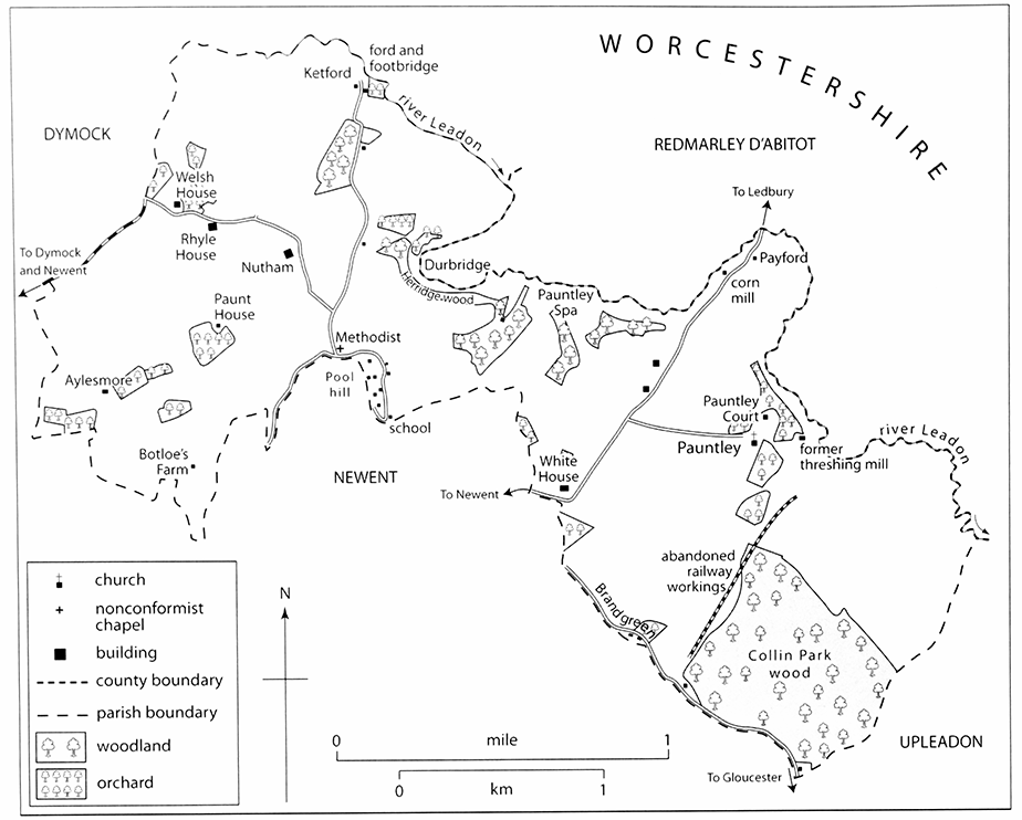
65. Little Place, Pool Hill
Among the cottages making up the scattered settlement of Pool Hill are later 17th- and 18th-century dwellings often with spindly timber framing. A tworoomed single-storeyed hovel, unheated, perhaps represents the parish poorhouse that stood there in the early 17th century. (fn. 107) In the 19th and early 20th century several cottages were enlarged and improved. Little Place, a two-bayed thatched house of 1½ storeys, was doubled in size in the mid 19th century by the insertion of a brick two-storeyed bay with end stacks between the house and its outbuilding, possibly a cider house and granary, to the east. (fn. 108) The whole made a single house and a short north-west wing was rebuilt in the 1930s on a larger scale using old timber and brick. (fn. 109) Beggar's Roost, built as a row of three thatched timber-framed cottages in the early 1840s, (fn. 110) was converted as a single picturesque house after 1910. (fn. 111) Of the new brick cottages one (Walden Villa) is dated 1855. (fn. 112) In the later 20th century some cottages were demolished but most were enlarged or rebuilt, a large timber-framed wing being added to the 18th-century Cherry Tree Cottage, and the nonconformist chapel below the hill was converted as a house. (fn. 113) At the beginning of the 21st century the hamlet had few entirely new houses.
MANOR AND ESTATES
Pauntley manor was created out of several preConquest estates and in the early 14th century it included 16 freehold properties, (fn. 114) including substantial estates in the detached part of the parish. Copyhold estates were located mostly if not entirely in the main part, (fn. 115) where the manor house, in the east at Pauntley Court, was the residence of the Whittington family in the later Middle Ages. (fn. 116) Members of the d'Abitot family of Redmarley D'Abitot (Worcs., later Glos.) had land there in the later 15th century and the mid 17th. (fn. 117)
The manorial estate centred on Pauntley Court was broken up in the early 20th century. In the west large holdings were formed by piecemeal purchases several times in the 19th and 20th centuries. Four farms acquired by Jonas Symonds passed separately after his death in 1830, (fn. 118) one eventually to the industrialist M.L. Attwood (d. 1915) of Stourbridge (Worcs.). (fn. 119) Other principal landowners were J.T.W.S. Holder in the mid 20th century and Mr David L. Dennis in the early 21st. (fn. 120)
PAUNTLEY MANOR
The medieval manor included the whole of Pauntley and small parts of Newent and Redmarley D'Abitot. (fn. 121) Its origins were four manors that Wulfhelm, Alfward, and Wiga held at Pauntley, Kilcot, Ketford, and Hayes (Hege) on the eve of the Norman Conquest and that Ansfrid of Cormeilles received on his marriage to a niece of Walter de Lacy. Ansfrid retained them in 1086, when they were assessed at a total of 4½ hides. (fn. 122) The medieval manor was held from the honor of Clifford for a knight's fee, (fn. 123) described sometimes as in Pauntley and Kilcot, (fn. 124) and in the late 14th and early 15th century the Mortimers, earls of March, were its overlords. (fn. 125) In the late 16th century part of the manor was said to be held of the manor of Dymock. (fn. 126)
Pauntley manor appears to have passed in the later 12th century from William de Solers to his son Richard. Richard's son Walter claimed the advowson of Pauntley church in 1208 (fn. 127) and Walter's son Richard remitted to Cormeilles abbey (Eure) services it owed for land held of him at Kilcot. (fn. 128) Walter de Solers held the manor in 1248 (fn. 129) and John de Breuse was its custodian in 1258 and 1265. (fn. 130) It passed to Thomas de Solers (fn. 131) and his son John de Solers (d. 1311) was succeeded in it by William of Whittington. (fn. 132) From William (fl. 1330) the manor passed to his son William (fn. 133) on whose death in 1358 it was retained by his widow Joan. Their eldest son William, (fn. 134) lord of Pauntley in 1377, died without issue. His brother Robert, lord in 1379, (fn. 135) was succeeded in 1423 or 1424 by his son Guy (d. 1440) (fn. 136) and the manor passed to Guy's grandson William Whittington (d. 1470) and to William's son John (fn. 137) (d. 1525). John's son and heir Thomas, (fn. 138) who settled it for a term on the marriage of his daughter Elizabeth (d. 1543) to (Sir) Giles Poole, (fn. 139) died in 1546 and the manor was inherited by Elizabeth's son (Sir) Henry Poole and her sisters Anne, wife of Brian Berkeley, Joan, wife of Roger Bodenham, Margaret, wife of Thomas Throckmorton, Alice, and Blanche, wife of John St Aubyn. (fn. 140) Henry, who succeeded his father at Sapperton in 1589, (fn. 141) acquired his aunts' interests (fn. 142) and at his death in 1616 the manor passed to his son Henry. (fn. 143) He sold it in 1620 to Edward Somerset, earl of Worcester. (fn. 144)
Edward Somerset died in 1628 and his son and heir Henry (fn. 145) settled the manor on his second son Sir John Somerset in 1632. (fn. 146) John, who fought on the royalist side in the Civil War, (fn. 147) evidently regained the sequestered estate in 1655 (fn. 148) and was alive in 1671. (fn. 149) In 1694 his son and heir Henry gave the manor to his son Edward. (fn. 150) Edward died in 1709 (fn. 151) and his widow Anne, who married John Paston of Horton in 1713, (fn. 152) retained the manor (fn. 153) until her death in 1731. (fn. 154) It then passed to the daughters of the third marriage of Charles Somerset (d. 1712), brother of Henry Somerset, namely Jane, widow of James Hooper, Frances, wife of Henry Scudamore, Carolina, later wife of Richard Brickenden, Clare, later wife of John Southcote, Ann, and Henrietta Maria, later wife of John Frederick (fn. 155) (fl. 1771). In 1748 Clare's share was acquired by her five surviving sisters. Henrietta Maria died later that year and Ann and Carolina, the last surviving sisters, in 1764 and 1770 respectively. In 1773 Henry Blachford Scudamore, grandson of Frances (d. 1760) and heir of Carolina, bought Ann's share of the manor from Henry Somerset, duke of Beaufort, (fn. 156) and at his death in 1795 he left his share to his wife Tamar. (fn. 157) She bought out the other owners (fn. 158) and broke up the estate by sales, Pauntley Court and most of the land being acquired under an agreement of 1807 by John Lindsay of Edgware (Middx). (fn. 159)
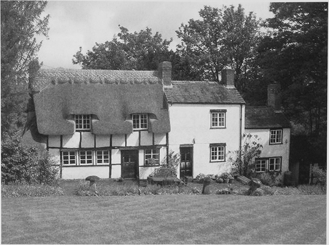
66. Pauntley Court from the north-east in 1996
Lindsay, to whom no deed of conveyance was made, sold his estate, including the manor, to John Stokes of Sheriff's Lench (Worcs.) in a series of transactions in 1810 and 1811. (fn. 160) In 1819 Stokes sold it with a deed of indemnity to David Ricardo, the political economist, (fn. 161) who owned 110 a. at Ketford that Tamar Scudamore had sold to Richard Loveridge in 1803. (fn. 162) After Ricardo's death in 1823 Pauntley Court descended with his Bromesberrow estate to Frank Ricardo, (fn. 163) who beginning in 1920 sold off the Pauntley Court estate. J.C. Davies of Ledbury bought the Court and its farm and his son H.J.P. Davies (fn. 164) sold the house in 1933, to the council of the Gloucestershire Home for Wayfarers, (fn. 165) and the rest of his land in 1937, part with the house's outbuildings to John Goulding and part to the Land Settlement Association. (fn. 166) J.R. Clapham bought the association's land in 1955 (fn. 167) and his son D.J. Clapham sold it to Simon Skelding in 2000. (fn. 168) Pauntley Court, which John Goulding bought after the Second World War, (fn. 169) was owned from 1970 by David Ayshford Sanford. He sold it in 1990 to the Skelding family which, following piecemeal purchases of adjoining land, owned 182 ha (450 a.) in 2007. (fn. 170)
Pauntley Court
The manor house was largely rebuilt in the late 16th and 17th century but it incorporates fragments of its late medieval predecessor. Foundations discovered under the garden north-east of the house indicate that the medieval complex was once more extensive. The present house (fn. 171) comprises ranges on three sides of a courtyard open to the south. Most of it is timber-framed and, except for the eastern range, of two storeys. The five-bayed western range, which has been truncated to the south, is reported to have an arch-braced roof with two tiers of windbraces and at the southern end smoke-blackened timbers. (fn. 172) The northern range, which is aligned differently to the other two and connected to them by later work, was built in at least three phases. It contains a narrow range with an external stack on the southern side and a parallel northern row of rooms under a separate, pitched roof; the upper floor of the southern part and the northern pile appear to have been added to earlier fabric in the 16th century. The upper floor on the north side may have been rebuilt in the 17th or 18th century. The house, where the Somerset family abandoned new building in stone after the Restoration, (fn. 173) was reduced in size as a farmhouse in the 18th century. (fn. 174) In the late 18th and 19th centuries much of the building was refaced in brick and render and new roofs were provided and in the 19th the western end of the northern range was rebuilt or enlarged as a four-bayed brick-built block. The eastern range was used as a farm building and has an external stone staircase.
In the early 19th century the house had a lodge at Payford, to the north, and another drive reached the house from Brand green, higher up to the south. (fn. 175) Immediately south of the house a large gabled dovecot in stone may have been among the buildings erected by the Somersets after the Restoration. A twostoreyed five-bayed range of stables, timber-framed with a brick infill, dates from the 17th century. (fn. 176)
OTHER ESTATES
Rhyle House and Botloe's Farm
William Wall of Ledbury, who may have been the descendant of Pauntley inhabitant Thomas Wall (fl. 1522), (fn. 177) died in 1717 leaving Rhyle House and Botloe's Farm, copyholds under the manor, to his daughter Dorothy, the widow of Thomas Jauncey (fn. 178) of Whitwick in Stretton Grandison (Herefs.). After Dorothy's death in 1743 (fn. 179) the combined estate belonged to her daughter Dorothy, wife of Revd Samuel Bethell (d. 1766) of Dinedor (Herefs.). (fn. 180) From Dorothy (d. 1776) it passed to her daughters Dorothy and Mary Bethell of Hereford (fn. 181) and c.1807 it reverted to the lord of the manor. (fn. 182) In 1812 John Stokes sold Botloe's Farm to Jonas Symonds (d. 1830), from whom the farm (40 a.) passed in turn to his daughter Mary Cummins (d. 1846) and her son Joseph Cummins (d. 1889). It was retained by Joseph's widow Emma in 1894 (fn. 183) and was owned by J.L. Stelfox in 1910. (fn. 184) Rhyle House (84 a.), (fn. 185) which John Stokes retained, (fn. 186) passed with the Pauntley Court estate (fn. 187) and was among parts of the estate offered for sale in 1921. (fn. 188) J.T.W.S. Holder owned the farm in the early 1970s. (fn. 189)
Pauntley Rectory
Pauntley church, to which a yardland as well as the Pauntley tithes belonged in the early 13th century, (fn. 190) was appropriated by Cormeilles abbey. (fn. 191) In the late Middle Ages Fotheringhay college (Northants.) administered the tithes as part of its Newent estate (fn. 192) and following the college's surrender of its possessions in 1547 (fn. 193) the tithes descended with Newent manor (fn. 194) until 1664 when Sir John Winter conveyed them to Thomas Awbrey. (fn. 195) At the turn of the century the impropriation belonged to Anthony Meeke (fn. 196) before passing by 1704 to Edward Somerset, the lord of the manor. (fn. 197) Edward by will proved 1710 left the impropriation to William Higford and others in trust to sell (fn. 198) and William's daughter Frances, widow of Henry Wakeman, (fn. 199) devised it by 1784 to her daughters Margaret, wife of Charles Welch of Evesham (Worcs.), and Winifred. It passed to Margaret's son Charles Welch, later of Hawford in Ombersley (Worcs.), (fn. 200) and in 1838 his widow Anne and Charles Willoughby Osborne were its owners. The tithes were commuted in 1841 for a corn rent charge of £450 (fn. 201) and Anne (d. c.1844) left her share to C.W. Osborne. (fn. 202) He was sole owner in 1865 (fn. 203) as was Emma Willoughby-Osborne in 1936 when tithe rent charges were redeemed. (fn. 204)
ECONOMIC HISTORY
Pauntley's economy depended almost entirely on agriculture with some variation provided by woodland crafts and rural trades.
AGRICULTURE
The Middle Ages
Lands in Pauntley, Kilcot, Ketford, and Hayes (Hege) worth £3 10s. in 1066 were valued at £4 and contained nine ploughteams in 1086. Two of the teams belonged to Ansfrid of Cormeilles's demesne, which employed 2 slaves, and the other seven to his tenants, namely 7 villans and 3 bordars. (fn. 205) Six ploughteams were recorded in Pauntley in 1220. (fn. 206) In the late 12th century one yardland belonged to a house at Nutham. (fn. 207)
In 1311 Pauntley manor had 100 a. of arable in demesne, as well as 6 a. of meadow, a several pasture, and a wooded park. Of the customary tenants, ten each held a half-yardland for a cash rent of 5s. and owed two days' work during mowing and four bedrips during the harvest. Another eleven tenants, four cottagers among them, owed smaller cash rents and three bedrips each. Sixteen various freehold estates or farms owed rents of assize totalling 22s. 2d. (fn. 208) Holdings with a half-yardland of arable changed hands in the later 14th century. (fn. 209)
Although Pauntley contained areas of open-field land in the later medieval period, (fn. 210) their precise location is undetermined and the dispersed nature of medieval settlement together with the remains of ancient woodland suggests that a substantial part of Pauntley was cleared for cultivation in closes. Of the parish's meadows one known in 1379 as Buckley was in divided ownership. (fn. 211) Meadowland lay all along the bank of the river Leadon. That below Great Herridge was not part of the manor estate in 1410, when it was known as Salbrook's mead, (fn. 212) and was possibly the land later called Sawbridge meadow. (fn. 213) Apple cultivation was under way by the later 15th century when John d'Abitot, in granting access to his woods in Pauntley, reserved the apple trees growing in them for his own use. (fn. 214) In 1522 John Whittington's household at Pauntley included his steward (fn. 215) but it is not known if any of his manorial demesne was in hand.
The Early Modern Period
Giles Poole, who farmed the manor at the beginning of the period, (fn. 216) from Sapperton confirmed his bailiff and rent collector at Pauntley in his post for life in 1561. (fn. 217) In the early 17th century, when six husbandmen were described as servants of Sir Henry Poole and a warrener was present, the manorial demesne was worked by several farmers and at least twelve others cultivated freehold or tenanted land. (fn. 218) Eight landholders had freehold farms, some if not most of them in the detached portion of the parish and several created by the amalgamation of smaller holdings. On the manor four tenants held land other than the demesne, and including mills at Payford, by lease. Copyhold estates granted for up to three lives conferred no right of free bench and the integrity of holdings was possibly long maintained, for the jury at a court of survey in 1619 disclaimed knowledge of any customary holdings having been divided into smaller parcels. (fn. 219)
More farms throughout the parish had been amalgamated by 1717, when four freeholders owed rent to the manor and five tenants held land on leases for years on lives. One leasehold, based on Paunt House, contained the sites of four other homesteads and two others were each made up of two holdings. A majority of nine copyholds also included the sites of more than one homestead. One of five cottage tenants occupied a cottage on the demesne and the principal leasehold farm, based on part of Pauntley Court, included a second cottage on the demesne. (fn. 220) In the 1770s Pauntley Court farm covered 536 a., four other farms had between 100 and 200 a., and about a dozen holdings were of less than 50 a. each. Of the larger farms those based on the White House, Aylesmore, and Paunt House were part of the Pauntley Court estate. The fourth took in Rylas (Rhyle House) and Botloe's Farm on the Bethells' estate. (fn. 221)
Dairying as well as corn and sheep husbandry were among the staples of Pauntley's larger farms throughout the period. Flocks of geese were also kept in the early 17th century (fn. 222) and new orchards were being planted before the mid 1680s. (fn. 223) In the early 17th century a meadow under Great Herridge was part of John d'Abitot's estate. (fn. 224) There was little meadowland in Pauntley away from the banks of the river Leadon and in the early 18th century the Pastons, owners of the manor, had five parcels in one of Hasfield's common meadows by the river Severn. (fn. 225) The manorial tenants had common rights on the pastures at Botloe's green, Pool hill, and Brand green where ancient intercommoning arrangements had been superseded by the early 17th century by counter accusations of encroachments during perambulations of the Pauntley and Newent parish boundaries. (fn. 226)
In 1771 Pauntley Court farm contained almost equal areas of arable and pasture and most of the available meadowland. The four other large farms were mostly arable. (fn. 227) At that time most of the land was used for growing wheat and other grain and was grazed regularly by flocks of sheep, a few turnips being included in the crop rotation as feed for both sheep and horned cattle. Little rye was grown despite the traditional association of that crop with the lighter, sandy soils of the area. The sheep kept were of a small species noted for its fine wool and sweet meat. Farmers devoted themselves principally to the cultivation of orchards, the production of cider being their main concern, and they eschewed the draining of wet lands as well as the watering of meadows. (fn. 228) The 445 a. recorded as under crops in 1801 grew mostly wheat and barley and included 35 a. of turnips. (fn. 229)
The Nineteenth and Twentieth Centuries
In 1839 the largest farms, both on Osman Ricardo's estate, were at Pauntley Court (458 a.) and Ketford (255 a.). (fn. 230) In 1851, when several hundred acres on the estate were farmed from Compton House in Newent, (fn. 231) John Butler, the farmer at Pauntley Court (460 a.), employed 18 men and boys on his land and farmers in the west at Aylesmore (145 a.), Rylas (88 a.), Paunt House (47 a.), and Nutham (20 a.) between them hired 15 farm labourers. (fn. 232) A bailiff managed Paunt House in the 1860s and 1870s and Henry Butler, the farmer at Pauntley Court, himself employed a bailiff in the 1900s. (fn. 233) In 1896 nine agricultural occupiers, all tenants, were returned for Pauntley (fn. 234) and in 1926 14 holdings, seven of them with under 20 a. each, and 21 full-time and 16 parttime agricultural workers were recorded. (fn. 235) Similar numbers of farms were returned in 1956 and 1986. In 1986, when one had over 50 ha (c.125 a.), three over 30 ha (c.75 a.), and two between 10 and 20 ha (c.25 and 50 a.), several of the smaller holdings were worked by part-time farmers and the larger farms hired in all six full-time workers. (fn. 236)
In 1813 John Stokes was in dispute with two flax dressers of Bengeworth (Worcs.) over part of the Pauntley Court estate set aside for their use. (fn. 237) In 1839 the parish contained 1,239 a. of arable and 326 a. of pasture and meadow. (fn. 238) Arable farming followed a four-course rotation, including grass leys, and lime was used commonly for manure. Although prone to flooding, the meadows by the Leadon were a source of hay. A list of animals that year included 1,500 sheep, 100 store bullocks, 30 stock cows, 50 oxen, and 70 horses. (fn. 239) Orchard cultivation remained important and at that time there were several hop gardens in Pauntley. (fn. 240) Turnips were grown on at least 272 a. in 1866, when wheat and barley covered over 700 a. and oats and rye 33 a. Some 405 a. in the parish was permanent pasture (fn. 241) and among the livestock returned in 1866 were 145 cattle, including 33 milch cows, 974 sheep, and 99 pigs. (fn. 242) The farm bailiff's wife at Paunt House in 1861 was a dairymaid. (fn. 243)
The area of arable in the main part of Pauntley shrank markedly in the later 19th century and that of permanent grass continued to increase in the early 20th. In 1926, when permanent pasture accounted for 622 a. and rough grazing for 29 a., 211 cattle, including 67 milch cows, 522 sheep, and 84 pigs were returned, the livestock numbers being higher than those recorded in 1896. Sugar beet filled a quarter of the area, less than 300 a., returned as under arable crops in 1926. Orchards covering 41 a. were reported in 1896 (fn. 244) and there was a cider mill at Payford mill in 1921. (fn. 245) Small areas of soft fruit and hops were also grown during the period and commercial poultry farming was introduced. (fn. 246) At the turn of the century Pool Hill's residents included a fruit dealer. (fn. 247) There was a specialist poultry unit at Redlea in 1939. (fn. 248) In 1933, in a venture involving an Anglican religious order and counting poet laureate John Masefield among its chief patrons, 40 a. was acquired with Pauntley Court to provide work and shelter for young male vagrants. The scheme, for which the Land Settlement Association purchased Pauntley Court farm in 1937, provided training in general agricultural work, market gardening, and orcharding and continued until the Second World War. (fn. 249)
In 1956 Pauntley remained predominantly pastoral in character, with 310 dairy and beef cattle and 618 sheep and lambs returned, and pig and poultry farming continued. Orchards covering 64 a. were also returned along with areas of soft fruit, mostly blackcurrants, and a market garden with a nursery. (fn. 250) In the following decades the areas devoted to fruit farming and horticulture grew. Large orchards were cultivated in several places, including Welsh House Lane where an outbuilding of Rhyle House was for a time the centre of a fruit farm (fn. 251) on which in 1972 the Three Choirs Vineyard was started. (fn. 252) A market garden was established at Ketford by the mid 1960s. (fn. 253) In 1986, when 209 ha (516 a.) of grassland, 9 ha (22 a.) of rough grazing, 503 cattle, and 665 sheep and lambs were returned, two of the principal farms specialized as dairy units and two were concerned mainly with fruit growing; 25 ha (62 a.) of orchards and soft fruit, including grapes, was returned and market gardens covered at least 27 ha (67 a.). (fn. 254) In the late 20th century, while some orchards were grubbed up, the area given over to viticulture at Welsh House Lane increased.
WOODLAND MANAGEMENT
Little is known of the management of Pauntley's woodland during the Middle Ages. In 1382 John Hard of Cheltenham granted two men the right to fell and take wood in Solers Grove and Kyndene for two years. (fn. 255) In granting similar access to a number of woods for slightly longer terms in 1466 and 1489 John d'Abitot reserved the apple trees as well as the principal timbers and their replacements. (fn. 256)
In the early 17th century the manorial demesne included 240 a. woodland (fn. 257) and the lord had a woodward on his staff. Some of the woodland was held by a tenant (fn. 258) but later the woodland on the Pauntley Court estate was usually all in hand. (fn. 259) In 1631 at least two charcoal burners, described as colliers, were working in Herridge wood. (fn. 260) Collin Park wood, the largest single area of woodland, supplied cordwood for the ironmaster Thomas Foley in the later 17th century (fn. 261) and the right there to harvest bass, bark from lime trees used in mat and basket making, provided a regular income in the early 18th. (fn. 262) Cordwood commanded a higher price in Pauntley than in Monmouth in 1771. A timber park created by 1765 (fn. 263) accounted for 34 of the 313 acres of woodland on the estate in 1803. (fn. 264) Much of the woodland was oak coppice felled every 20 years. (fn. 265) In the late 19th and early 20th century there were annual sales of timber and coppice wood from Collin Park and of alders, oaks, and ashes from elsewhere in Pauntley. (fn. 266) A Pool Hill resident dealing in wood in 1839 remained in business in 1861. (fn. 267) The estate's woods were patrolled by a gamekeeper in the later 18th century (fn. 268) and there was a resident keeper in the early 20th century, (fn. 269) when sporting rights over the estate were in the hands of a lessee. (fn. 270) Collin Park, where charcoal burning was temporarily reestablished in 1997, continued to be maintained as deciduous plantation, mainly lime and oak, under traditional coppice management and in 2004 the Gloucestershire Wildlife Trust managed part of it as a reserve. (fn. 271)

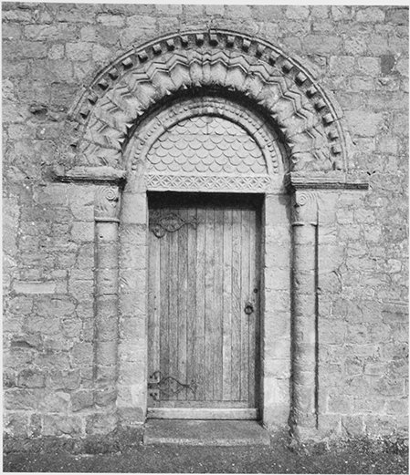
67. Payford Mill
MILLS
Ansfrid of Cormeilles had a mill on his estate in 1086 (fn. 272) and the manor included a water mill in the early 14th century. (fn. 273) In 1358 the lord of Redmarley D'Abitot owned a corn mill called Pauntley mill (fn. 274) and in 1410 a water mill stood below Great Herridge wood at a place called Thurbache, perhaps on the Redmarley side of the Leadon at Durbridge. (fn. 275) A mill operating within Pauntley on a tributary stream below the wood in the later 18th century (fn. 276) belonged to a farm on the Pauntley Court estate. (fn. 277) It had been abandoned by the late 1880s (fn. 278) and little remained of the building in the mid 20th century. (fn. 279) In 1605 George and Martha Wood quitclaimed a mill in Pauntley to Sir Edward Winter. (fn. 280)
In the early 17th century, when he was served by a miller, (fn. 281) the lord's corn mill on the Leadon at Payford had several pairs of stones and was used traditionally by most of the manor's tenants even though they were not bound by custom to do so. (fn. 282) In the early 19th century the miller, William Holland, acquired the mill and in the early 1830s he left it to Richard Birt. (fn. 283) Later the mill was back in the Pauntley Court estate and, with two pairs of stones, (fn. 284) was used regularly until the early 1920s. (fn. 285) The mill equipment, which was damaged by floods in 1947, was restored in the 1980s. (fn. 286) The wheel pit and undershot wheel, apparently of the 19th century, also survive and the sluice gate has been reconstructed. (fn. 287)
In the early 19th century a mill was built by the river east of Pauntley Court to house a threshing machine (fn. 288) powered by water from a pond fed by a stream rising in Collin Park wood. (fn. 289) Part of Pauntley Court farm, (fn. 290) the mill was not used by the late 19th century (fn. 291) but remained standing in the early 21st.
INDUSTRY AND TRADE
Digging in the coal deposits near the ground surface in the west of Pauntley (fn. 292) had begun by 1797, when a miner died in the parish. (fn. 293) Ten years later prospecting had not led to mining on any significant scale. (fn. 294)
In 1608 Pauntley's men included a smith and a turner. (fn. 295) A smith lived at Brand green in the mid 17th century and the first recorded shoemaker in the parish died in 1778. (fn. 296) A smithy operated next to a new house below Pool hill in 1815 (fn. 297) and the hamlet's residents in 1851 included a sawyer, a shoemaker, a glovemaker, and a stone mason. (fn. 298) Traditional crafts such as thatching, basket making, and hurdle making were practised in Pauntley in the later 19th century (fn. 299) and residents in the early 20th century included a farm machinery operator, two road workmen, and a railway fireman. (fn. 300) A man at Pool hill kept a shop in 1819 (fn. 301) and a grocer living there in 1861 was among a number of shopkeepers recorded in Pauntley in the later 19th century. (fn. 302) Residents in 1863 included a postman (fn. 303) and in the mid 1870s a local man ran a weekly carrying service between Pauntley and Gloucester. (fn. 304) The farmer at Rhyle House traded as a threshing machine proprietor and a guano and sack merchant in the 1880s. (fn. 305)
The smithy below Pool hill closed during the First World War and a local carrying business ceased at the same time. After the war, as agriculture and traditional crafts together provided ever fewer jobs, some residents found employment in engineering, transport, and public services. A hurdle maker lived at Pool Hill in the 1930s. There was a post office and shop at Pool Hill in 1906. In the 1920s the hamlet gained a second shop (fn. 306) but from the mid 1970s it was without both and from the mid 1980s a post office. (fn. 307) In 2000 most of the hamlet's residents worked away in a variety of professional, managerial, and skilled jobs, including law, education, nursing, personnel services, engineering, and computing. (fn. 308) Businesses in Pauntley included a riding school and, at Payford mill, the studio of a garden equipment designer. (fn. 309)
LOCAL GOVERNMENT
MANORIAL GOVERNMENT
There was a manor court in 1311. (fn. 310) The only evidence of its jurisdiction is a copy of the articles of enquiry for, and the presentments at, a court of survey held in 1619 for Henry Poole. The manor court, which custom designated the sole forum for recording transactions in copyhold land, (fn. 311) presumably convened until at least the early 18th century. (fn. 312)
PAROCHIAL GOVERNMENT
In the early 17th century two churchwardens, two overseers of the poor, and two surveyors of the highways were chosen from among landowners in the two parts of the parish. Deputies occasionally served. (fn. 313) Later one churchwarden, one overseer, and one surveyor were appointed, all three offices, together with that of constable, being filled by rota between 16 farmhouses, including Pauntley Court. The rota system was abandoned by the mid 1780s. (fn. 314)
By 1619 two poorhouses had been built on waste land on Pool hill and at the Hollend. (fn. 315) The parish's expenditure on poor relief in 1776 was higher than that of many of its neighbours but was much less in the mid 1780s, (fn. 316) when about five adults received weekly pay. Much larger numbers received occasional help from the late 18th century, corn being given to the poor in 1795 and 1796, and about 15 people were usually on relief in the 1820s and early 1830s. Occasional measures taken by the parish in the late 18th century included apprenticing children to local farmers, employing women to spin flax or hemp, and paying for a family's lodging at Rudford. In 1785 the parish decided to assist a man with the cost of a new house on Pool hill including that of a lease of land for its site. In 1812 and 1813 the parish made several payments to the Ledbury overseers and in 1820, the year the poorhouse on Pool hill was rebuilt, it settled a substantial doctor's bill and reimbursed a man for a payment to the Gloucester infirmary. An annual allowance of two guineas to the overseer, started in 1794, was withdrawn in 1798, following objections from magistrates, but had been reinstated by 1803 and was gradually increased. (fn. 317) In the early 19th century the annual cost of relief more than doubled (fn. 318) but by the mid 1820s it had fallen back slightly. (fn. 319) At that time the rent of a garden at Pool Hill supplemented the income available for relief. Among moves to limit expenditure was a stipulation in 1830 that only the churchwarden or overseer could authorize the services of a doctor attending the parish. (fn. 320) In 1835 administration of relief passed to the guardians of the new Newent poor-law union. (fn. 321)
In 1676 a former surveyor of the highways sought reimbursement of his expenses on works at Ketford and Payford bridges. (fn. 322) Pauntley shared responsibility for Payford bridge with Redmarley D'Abitot (Worcs., later Glos.) and in 1815, after John Stokes had built a new bridge there, it decided to pay him £20 for bridle rights across it and to share with him the maintenance cost for the part within Pauntley. (fn. 323) Responsibility for Ketford bridge was shared with Dymock. (fn. 324)
In the late 18th century the churchwarden's, surveyor's, and constable's expenses and also the parish clerk's salary were funded at least in part from the poor rate and for over ten years until 1798 the churchwarden's expenditure was included in the overseer's account. The constable alone continued to be paid from the poor rate after 1798. (fn. 325) From 1843 the vestry appointed a salaried surveyor of highways and there were again two churchwardens, one chosen by the vicar and the other by the parish. (fn. 326)
SOCIAL HISTORY
SOCIAL STRUCTURE
In 1327 William of Whittington, lord of the manor and a knight, was assessed for tax in Pauntley at just over 6s. Of the other men and women there, including landholders in the main part of the parish, one was assessed at just over 5s. 5d., one at 4s., three at 3s., and four between 2s. and 2s. 6d. The lower assessments were eleven at 1s. or more and six between 6d. and 8d. (fn. 327) At that time there were some 16 free and 21 customary tenants on the manor. Some if not most of the free tenants lived in the detached part of the parish. All of the customary tenants owed labour services as well as cash rents. (fn. 328)
The Whittingtons maintained the manor house as their principal residence and by the time of Robert Whittington (d. 1423 or 1424), the owner of estates elsewhere, (fn. 329) lived in considerable opulence. (fn. 330) Robert's younger brother Richard (d. 1423), the third son of William Whittington (d. 1358), went to London where he achieved fame as merchant and mayor, (fn. 331) and Robert's son and heir Guy (d. 1440) added to the family's estates by marriage. (fn. 332) In 1522 John Whittington, with goods and chattels worth £100, was the wealthiest lay person in the region let alone the parish. Including two chaplains, most of the other inhabitants assessed in Pauntley for the military subsidy that year had goods worth between £1 and £4. For six men no assessment was made. Of two men with goods valued at £20, (fn. 333) James Hill probably owned Hill House in the detached part of the parish (fn. 334) and Thomas Wall may have been a copyholder at Rhyle House or Botloe's Farm. (fn. 335)
In the later 16th century the lords of the manor were at least occasionally resident. Sir Henry Poole raised his family there in the 1570s and 1580s and his eldest daughter Elinor (d. c.1647), wife of Sir Richard Fettiplace and author of a treatise on household management, lived there in 1602. (fn. 336) Among other gentry families in Pauntley at that time the Pauncefoots, headed by William (d. 1617), lived in the main part of the parish. (fn. 337) Of 41 people listed in Pauntley in 1608 at least 18 being described as husbandmen were farmers, of whom six together with a gardener and a miller were described as Sir Henry's servants. Of seven other servants, three worked for Thomas Hooke, a landowner in the detached part of the parish, and one for William Pauncefoot. (fn. 338)
In 1672, when 18 persons in the whole parish were assessed for hearth tax, the only houses in the main part with more than 3 hearths were those occupied by the Attwoods (12 hearths), the Cruyses (8 hearths), and the Pauncefoots (6 hearths). The majority of the other houses had only 1 hearth. (fn. 339) While the Cruyses lived at the Hollend (fn. 340) and the Pauncefoots at the White House, (fn. 341) the Attwoods occupied Pauntley Court in the absence of Sir John Somerset. He was living in Belgium in 1671 (fn. 342) and his son Henry, described as of Pauntley Court in 1694, (fn. 343) also lived out his days abroad. (fn. 344) Edward Somerset was resident and William Attwood resided at the White House in the early 18th century. (fn. 345) Edward's widow Anne remained at the Court when married to John Paston (fn. 346) but the Somerset heiresses, although several of them were, like their parents, buried at Pauntley, were non-resident (fn. 347) and from the Court farmer Daniel Dew (fl. 1771) acted as local agent, collecting rents and maintaining the estate's woods. (fn. 348) Ann Somerset (d. 1764) is commemorated in the church by a monument by Thomas Symonds of Hereford. (fn. 349) Other memorials of the period, those to members of the Attwood and Pauncefoot families included, were more modest with carved headstones marking some farmers' graves in the churchyard. (fn. 350) During the whole period there was no resident clergyman.
John Stokes (d. 1828), owner of the Pauntley Court estate, farmed much of the land from Pauntley Court himself even after he sold the estate in 1819. (fn. 351) The Ricardos, owners of the estate from 1819, were nonresident (fn. 352) but Osman Ricardo established and sustained a day school at Payford in the mid 19th century. (fn. 353) Away from Pauntley Court, the principal farmers occupied the main farmsteads in the west of Pauntley. Alexander Symonds, whose father Jonas (d. 1830) bought four of the farms there, (fn. 354) lived at Aylesmore (fn. 355) and from 1827 to 1843 was the churchwarden. Mary Perkins, whose family farmed at Rylas (Rhyle House) by the late 1770s, (fn. 356) served as the overseer several times, the first in 1827. (fn. 357) A later farmer at Rylas, John Cowmeadow (d. 1863), (fn. 358) is commemorated at the church in the glass of the chancel east window.
In the mid 19th century the households of most of the five main farmers, headed by John Butler at Pauntley Court, included domestic servants and some also included farm servants. Elsewhere in 1851, out of a population of 210, there were 27 agricultural labourers, 16 of them on Pool hill where a small community of labourers, craftsmen, and tradesmen, most of them tenants, occupied some 24 small cottages. (fn. 359) In the whole parish the number of households receiving regular support through the poor law, about five in the mid 1780s, had doubled by the end of the century and was about 15 in the 1820s and early 1830s. (fn. 360) In 1845 ten of the poorest men were exempted from all parish rates on account of poverty. (fn. 361)
In the later 19th century a few members of the gentry and the professional and officer classes as well as new farming families moved into Pauntley. (fn. 362) The White House, which had been occupied by the parish priest in the later 1830s, (fn. 363) was let as a private residence, (fn. 364) occupants briefly including Charles Griffin (fn. 365) (d. 1879), a former deputy chief constable for the county. (fn. 366) In the later 1880s it became the residence of W.P. Thackwell (d. 1922), the younger son of a landowner in Dymock, (fn. 367) and with Pauntley Court, the farmhouse of Henry Butler in 1901, remained among the chief houses in Pauntley in the early 20th century. (fn. 368) Pauntley Court, which from 1933 was a transient home for young men being trained on the land for regular work, (fn. 369) was a hostel for refugees during the Second World War (fn. 370) and reverted to domestic use afterwards.
CHARITIES FOR THE POOR
Charles Griffin by will proved 1879 left £300 to fund weekly payments of 1s. to six elderly people from Pauntley, Pool Hill, and Brand Green for six months over the winter and 10s. to each of them for a Christmas dinner. (fn. 371) From 1886, when the individual Christmas bonus was reduced from 5s. to 3s., the charity distributed £8 2s. a year in cash (fn. 372) and in 1942 and following years the six recipients shared £6 18s. given as a single Christmas gift. (fn. 373) The charity helped fewer people in the early 1970s (fn. 374) and was restricted to Pauntley parish by a Scheme of 1975. It lapsed in 2006. (fn. 375)
Pauntley's celebrations to mark the Golden Jubilee of 1887 included the gift to cottagers of 41 blankets paid for by collections. (fn. 376) From 1903, if not earlier, a fund raised by church collections met altar expenses and assisted the sick and needy. Managed by the vicar, it mostly helped widows and it continued in 1918. (fn. 377) A similar fund provided Christmas payments, mostly of 3s. 6d., to 11 people in 1935 and, having increased individual payments to 5s., had 8 beneficiaries in 1945 and 6 in 1952. (fn. 378)
EDUCATION
In 1798 William Holland, the miller at Payford, ran a school. (fn. 379) In 1817 the parish provided clothing and books for 8 poor children from Pauntley attending a school taught by Thomas Davies, the perpetual curate, probably at the house he occupied in Newent. (fn. 380) A church Sunday school was established in Pauntley in 1824 and Wesleyan Methodists also ran a Sunday school there in 1833. (fn. 381) In 1838 Osman Ricardo opened a day school at Payford. It taught boys and girls separately and its teaching staff included the master's wife and an assistant in 1851. (fn. 382) In 1868, when with Ricardo's continued support it taught 60–70 boys from a wide area, girls attended schools in Newent and Upleadon. (fn. 383) Two women teachers lived on Pool hill in 1861 (fn. 384)
In 1869 a room was built at the top of Pool hill for a National school to serve both Pauntley and the adjoining part of Newent. (fn. 385) The school, on land donated by J.H. Frowde of Walden Court, (fn. 386) opened in 1870 under the management of T.P. Little, the vicar of Pauntley, and was supported mainly by voluntary contributions and pence. (fn. 387) It had an average attendance of 55 in 1885 (fn. 388) and of 53 in 1904. (fn. 389) The building was altered, possibly in 1895, to accommodate a room for the infants. (fn. 390) The school was later known as Pauntley C. of E. school and after the First World War the average attendance fell to 40 or less. (fn. 391) The older children went to school in Newent from 1950 (fn. 392) and Pauntley school, where attendance fell to 16 in the mid 1970s, (fn. 393) had 53 children on its roll in 2005. (fn. 394)
During the Second World War there was a school at Payford mill for French and Belgian refugee children living at Pauntley Court. (fn. 395)
SOCIAL LIFE
In the early 19th century farm labourers in Pauntley maintained the custom of assembling in a wheat field on the eve of Twelfth Night to light twelve fires in a row at the ends of twelve lands and to toast the harvest and their masters in cider around the largest fire. On returning home they feasted on caraway cakes, soaked in cider, claimed as their reward for sowing the corn. (fn. 396) In the mid 19th century people from Newent, Ledbury, and elsewhere congregated at a spring (Pauntley Spa) by the river Leadon upstream of Payford to warm and drink its waters at first light on May Day and run about a field in a figure of eight to obtain the desired, laxative result. The custom was waning by 1893 after a farmer's objections to his hedges being stripped for firewood. (fn. 397) In 1933 fishing rights in a stretch of the Leadon belonged under lease to a Gloucester angling club. (fn. 398)
Pauntley appears never to have had a licensed public house. There was a church house in 1610. (fn. 399) The parish vestry met in the later 18th century in the church and sometimes in the mid 19th century at the incumbent's house. The schoolroom built in 1869 became the usual place for meetings. (fn. 400) In 1950 a village hall for Pauntley was opened at Brand Green. Erected as a memorial to the dead of the Second World War, the wooden hut was the gift of R. Smith of Pauntley Place and was intended as a temporary structure. (fn. 401) Among the groups using it was a local branch of the Women's Institute formed in 1950. (fn. 402) The hall, which has been modified, remained in use in 2007.
RELIGIOUS HISTORY
EARLY HISTORY AND STATUS OF THE PARISH CHURCH
Pauntley church was a chapel confirmed among the possessions of Cormeilles abbey (Eure) in 1181 (fn. 403) and appropriated by the abbey together with the church at Newent under an episcopal licence of 1195. (fn. 404) It was served in the late Middle Ages by a resident, stipendiary chaplain (fn. 405) and in 1522 two chaplains had salaries of £5 6s. 8d. each. (fn. 406) Although Pauntley continued as a chapelry of Newent in the mid 16th century, (fn. 407) it then was sometimes described as a separate vicarage (fn. 408) and later was served by its own curate with a stipend paid by the owner of the Pauntley tithes. (fn. 409) The stipend was £7 in 1603 (fn. 410) and was set at £13 6s. 8d. by 1650. (fn. 411)
After endowment in the mid 18th century (fn. 412) the living became a perpetual curacy (fn. 413) and from 1868 was officially styled a vicarage. (fn. 414) It was united with Oxenhall in 1918 (fn. 415) and with Upleadon in 1955. (fn. 416) Pauntley and Upleadon were united with Oxenhall and Redmarley D'Abitot in 1977 (fn. 417) and other parishes were added to the united benefice later. (fn. 418)
PATRONAGE AND ENDOWMENT
In the early 13th century the abbot of Cormeilles defended his house's rights in Pauntley church against Walter de Solers, who, having asserted that it had belonged to his grandfather William de Solers, (fn. 419) quitclaimed any right in the church, its property, and advowson to the abbey. (fn. 420) The patronage passed with the church to Fotheringhay college (fn. 421) and from the mid 16th century with the Pauntley tithes in lay hands. (fn. 422) With Edward Somerset and his successors in the 18th century being Roman Catholics, the bishop appointed clergy to serve the church (fn. 423) and the living remained in his gift after he collated to the perpetual curacy in 1782. (fn. 424)
Apart from fees, the curate's income in the 17th century and in much of the 18th was the stipend paid by the impropriator. (fn. 425) Occasional grants from Queen Anne's Bounty to augment the curate's income began in 1767 (fn. 426) and were used to buy land in Newent and Dymock. (fn. 427) In 1844 the Ecclesiastical Commissioners granted the living £14 a year (fn. 428) but its value in 1856 was only £64, raised by 1864 to £80. (fn. 429) No house or building belonged to the perpetual curacy. (fn. 430)
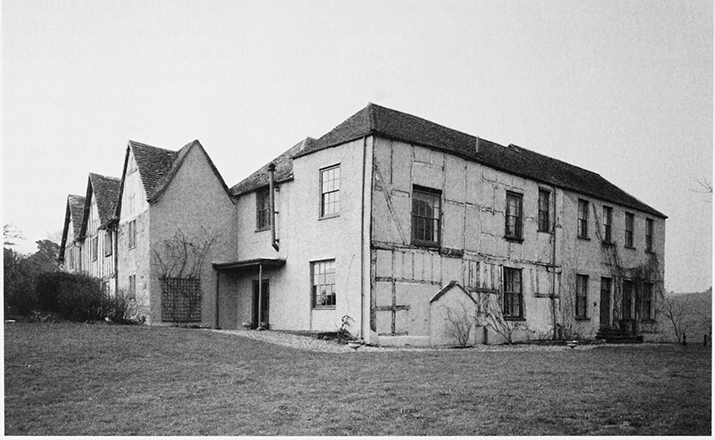
68. Pauntley church: the south doorway in 1996
RELIGIOUS LIFE
The Middle Ages
The ornate decoration of the church's chancel arch and south doorway, which have capitals and a range of ornament characteristic of the 'Dymock school', (fn. 431) indicates the high quality of Pauntley's early 12thcentury chapel. (fn. 432) Enlargement resulted in a threebayed nave with a 13th-century north doorway, which is sheltered by a timber-framed porch of the 14th century and retains medieval ironwork on the door. The nave windows were enlarged and given Decorated tracery in the 14th century. A late medieval west tower, of two stages, contains two 14th-century bells in a frame capable of supporting four bells. (fn. 433)
In the later Middle Ages the Whittingtons were regular benefactors of the church, which was dedicated to St John the Evangelist by 1423. (fn. 434) A chapel of St George, described in 1440 as new, was built on the south side of the chancel to house a chantry founded by Guy Whittington and to serve as his family's mortuary chapel. (fn. 435) It has a west doorway and contains a pillar piscina. The chancel, which may have been enlarged in the 13th century, was remodelled in the same style as the chapel and given a wagon roof and an aumbry with a piscina. Windows in the chancel and the tower contain fragments of glass displaying the Whittingtons' arms. (fn. 436) Thomas Whittington (d. 1491) of Over Lypiatt endowed a service of Our Lady in the church and in the later 1520s Thomas Whittington maintained a right to appoint its priest on the authority of its feoffees. (fn. 437)
Of the chaplains that served the church Thomas, who possibly became the bishop's constable at Bishop's Castle (Salop.), was assaulted midway between Pauntley and Hereford in 1346. (fn. 438) In 1397, when several parishioners absented themselves from church, the chaplain was non-resident, the church's manse having fallen down through the rector's neglect, the baptistery or font was left unlocked, and the rector was failing to honour an obligation to supply two processional candles. (fn. 439) The farmer of the rectory paid for repairs to the chaplain's house in 1409 (fn. 440) and received parishioners' offerings for the purchase of wax in the late 15th century. (fn. 441)
From the Reformation to the Restoration
In 1544 Pauntley had as curate Thomas Twinning, formerly a monk at Tewkesbury, (fn. 442) who was unlearned, being unable in 1551 to recite the Ten Commandments. (fn. 443) There were 90 communicants in 1548 when, at its dissolution, the chantry of St George was served by Hugh Dowsing, vicar of Tirley. (fn. 444)
In 1576 the curate was unlicensed, (fn. 445) there had been no sermons for a long time, and the young were not taught the catechism. (fn. 446) William Whitcott, curate in 1593, was classified as a sufficient scholar but no preacher (fn. 447) and was said in 1609 to be unlearned in scripture and Latin and to have conducted marriages irregularly. (fn. 448) He resigned in 1613 on account of age. Local gentry from both parts of parish attended the church, (fn. 449) members of the Pauncefoot family taking their place in the south chapel. (fn. 450) In 1603, when the number of communicants was put at 80, one man was recusant (fn. 451) and in 1625, when the parish clerk read prayers in the church although suspended from his duties, six people failed to take communion at Easter and another man did not come to church. (fn. 452) In 1610 the miller at Payford had a copy of The Imitation of Christ as well as a Bible. (fn. 453) In the mid 1640s John Skinner, who later conducted a nonconformist ministry elsewhere, was curate (fn. 454) and in 1650 his successor was an accepted preaching minister. (fn. 455)
The Parish Church and Roman Catholicism after the Restoration
Following the Restoration the church was almost invariably served by a non-resident curate and often with Oxenhall. (fn. 456) It acquired a new pulpit and a third bell in 1676 (fn. 457) and its wooden chest is dated 1679. Among its plate at that time was a silver chalice, (fn. 458) perhaps that dated 1651 that was later returned to the church from a nearby farmhouse. (fn. 459)
Although only conformists were recorded in Pauntley in 1676 (fn. 460) Roman Catholics gathered occasionally in an upper room of Pauntley Court, (fn. 461) the manor having been in Catholic ownership since Henry Somerset's accession in 1628. (fn. 462) According to a later writer popular sentiment during the Popish Plot of 1678 led to the abandonment of plans to enlarge the house. (fn. 463) Although some members of the Somerset family lived on the Continent, (fn. 464) there was a Catholic presence in Pauntley in the early 18th century (fn. 465) and a building at Pauntley Court was known as the chapel house. (fn. 466) In the mid 1720s a priest was a member of the Pastons' household at Pauntley Court (fn. 467) and their steward Richard Redfearn (d. 1727), a co-religionist, was buried in the chancel of the church. (fn. 468)
The Established Church and Nonconformity from the Mid Eighteenth Century
In the mid 18th century the parish church had one Sunday service, held alternately in the morning and afternoon. From that time the curacy was usually combined with Upleadon as well as Oxenhall (fn. 469) and the three parishes were held together until 1823. Pauntley continued to be served with Upleadon until 1841. (fn. 470) In the mid 1780s a west gallery and a ceiling were inserted in the church and the Ten Commandments were drawn for display in it. (fn. 471) A new painting of the royal arms was acquired in 1817, the first of two years in which the parish employed a singing teacher for the church choir. The choristers were instructed in psalmody in 1830 and the choir received more instruction in the mid 1830s. (fn. 472) In 1825, when the perpetual curate was resident, the church still had a weekly service and a communion service every other month attracted between 10 and 14 communicants. A church Sunday school started in 1824 taught up to 60 children, some of them from Upleadon. (fn. 473)
In 1814 a nonconformist minister from Newent registered a field on the hillside north-west of Pool Hill as a place of worship (fn. 474) and the next year a new Wesleyan Methodist chapel opened below it. (fn. 475) At that time John Stokes, whose Pauntley Court estate included the field, was refusing to contribute towards the repair of the parish church. (fn. 476) Although a preacher on the Ledbury circuit had registered several houses in the Pauntley area by 1820, (fn. 477) the chapel below Pool Hill was the only nonconformist meeting place in the parish in 1825. (fn. 478) A Sunday school run by the Wesleyans taught 38 children in 1833. (fn. 479)
From 1841 the parish church was served again with Oxenhall. T.M. Sherwood, the incumbent, (fn. 480) had the gallery removed in 1845 but his offer to fund two thirds of the cost of restoring the church was narrowly rejected by the vestry. In 1847 and 1848 the south wall and east gable were rebuilt, the south doorway being reset, and the nave was reroofed in a less costly plan from a London architect, possibly Richard Armstrong. (fn. 481) R. Hodges donated a new font (fn. 482) and in 1850 the Incorporated Church Building Society made a grant for reseating the whole church. (fn. 483) Restoration of the south chapel was inhibited by uncertainty over its ownership. (fn. 484) On Easter Sunday 1851 the church with 134 sittings, two thirds of them free, had a congregation of 65 at an afternoon service. The Methodist chapel below Pool hill, with seats for 204, held three services on that day and usually had smaller congregations. (fn. 485) In 1856 residents of Redmarley D'Abitot (Worcs., later Glos.) gave the church a chalice and paten in return for the accommodation afforded them while their church was being rebuilt. (fn. 486) Charles Griffin by will proved 1879 made a bequest for heating the parish church (fn. 487) and in 1907 an organ was acquired to replace the harmonium there. (fn. 488)
In the early 1870s the vicar of Pauntley held occasional evening services in the new schoolroom at Pool Hill (fn. 489) and in the mid 1880s, after the initiation of a Sunday church service near by at Walden Court in Newent, (fn. 490) regular Sunday evening services were held at the school. (fn. 491) In the late 19th century the Methodist chapel below Pool hill (fn. 492) had occasional weekday as well as Sunday services and in 1911 its Sunday congregation numbered eight. (fn. 493)
After the First World War
The parish church continued to be served from Oxenhall (fn. 494) and in the 1930s and 1940s, when donations paid the organist's salary, occasional services were held in the Pool Hill schoolroom. (fn. 495) Restoration of the church was renewed in the 1950s and the corporation of the City of London made several gifts in memory of Richard Whittington, including an alms dish in 1959, when the lord mayor of London and representatives of the Mercers' Company attended celebrations marking the supposed 600th anniversary of Whittington's birth. (fn. 496) Both the corporation and the company contributed in 1968 to funds for restoration of the fabric and windows, and new fittings in 1989 included a stall and carpets given by the corporation to mark the 800th anniversary of the office of mayor of London. (fn. 497) Services, provided from Upleadon from 1955, (fn. 498) were arranged from Redmarley D'Abitot from 1977 (fn. 499) and a small congregation attended a regular Sunday service in 2004.
The Methodist chapel below Pool hill fell into disuse and although it was re-opened in 1950 it closed finally four or five years later. The last burial took place there in 1965 and the chapel, having become derelict, was sold in 1977 and converted as a house. (fn. 500)