A History of the County of Gloucester: Volume 6. Originally published by Victoria County History, London, 1965.
This free content was digitised by double rekeying. All rights reserved.
'Parishes: Moreton-in-Marsh', in A History of the County of Gloucester: Volume 6, ed. C R Elrington (London, 1965), British History Online https://www.british-history.ac.uk/vch/glos/vol6/pp240-250 [accessed 30 April 2025].
'Parishes: Moreton-in-Marsh', in A History of the County of Gloucester: Volume 6. Edited by C R Elrington (London, 1965), British History Online, accessed April 30, 2025, https://www.british-history.ac.uk/vch/glos/vol6/pp240-250.
"Parishes: Moreton-in-Marsh". A History of the County of Gloucester: Volume 6. Ed. C R Elrington (London, 1965), British History Online. Web. 30 April 2025. https://www.british-history.ac.uk/vch/glos/vol6/pp240-250.
In this section
MORETON-IN-MARSH
The parish of Moreton-in-Marsh, in the north-east corner of the county, consists mainly of a flat area lying between two branches of the River Evenlode and crossed by a third, sheltered on the west side by the north-east slopes of the Cotswolds. The small town of Moreton-in-Marsh, formerly a market town, stands on the Foss Way, which crosses the parish from north to south, in the north part of the parish. By the late 19th century the town had extended beyond the north boundary of the parish (fn. 1) which followed the road from Chipping Norton as far as the stream running through the middle of the parish and then ran up the stream; (fn. 2) and in 1936 91 a. were transferred from Batsford, bringing the whole of the town within the parish, which was then 1, 105 a. in area. (fn. 3) The part transferred from Batsford included Queen Victoria's Garden, given to the town in 1897 by Lord Redesdale. (fn. 4) Coldicote, in the south-east corner of the parish, was separately assessed for subsidy in 1327, (fn. 5) and may have been a small hamlet at that time, though later it comprised only a single farm. (fn. 6)
As the name implies, Moreton lies mainly on open moorland. The popular theory of the derivation of the suffix 'in-Marsh' (an adaptation from Henmarsh, the usual suffix from the 13th century to the 18th) from the word march, referring to the position of Moreton on the edge of the county (fn. 7) has given way to the derivation from 'marsh' (fn. 8) This interpretation is supported by the fact that parts of the parish, especially near the church where the earliest settlement lay, are marshy and subject to flooding. The south and east boundaries of the parish are formed by two branches of the River Evenlode; the stream crossing the middle of the parish was probably the one called Moorbrook in the 17th century, when the stream in the south was called Stowbridge brook. (fn. 9) The parish is flat, lying at a height of c. 400 ft. The north part, including the town, is on glacial gravel; (fn. 10) the rest of the parish, where the open fields lay on the east and west sides of the Foss Way until the inclosures in the 17th century and in 1821, (fn. 11) is on boulder clay with alluvial soil and a narrow belt of Lower Lias beside the streams. (fn. 12) The parish has always had a considerable area of meadow, the demesne meadow lying on the west side (fn. 13) and the common meadow, usually called Moreton Heath, lying in the north-east (fn. 14) There is no woodland in the parish. During the Second World War the northeast part was used as an airfield, which was closed in 1959 (fn. 15) and used as a Fire Service training centre in 1962.
The earliest settlement in Moreton was on the west side of the stream which crosses the parish; it was near the church in that part of the town which was still called the Old Town in 1962. The village was a very small one until in the 13th century the Abbot of Westminster sought to exploit the commercial advantage of its proximity to the Foss Way. The building of a new town between 1222 and 1246 by the abbot, Richard of Barking (who assigned the rent of the new town to his anniversary), (fn. 16) probably coincided with the grant of a weekly market at Moreton in 1228. (fn. 17) The new town, called New Moreton to distinguish it from the old village which came to be called Old Moreton, (fn. 18) was built along the Foss Way, and the wide roadway where a market hall was built by the 18th century (fn. 19) probably always served as a market place. The assessment for tax in 1327 suggests that Moreton was still a very small place, (fn. 20) but during the next few centuries it expanded mainly northwards along the Foss Way. In the 17th century houses were built on the west side of the Foss Way almost as far as the north boundary, in Corder's Lane off the west side of the Foss Way (where cottages of that date or earlier (fn. 21) were pulled down in the 20th century), and between the Foss Way and the old part of the town, in Church Street and Oxford Street (formerly Kimbolton Street). (fn. 22)
During the 18th century extensive rebuilding and refacing of houses took place, especially along the main road, and several large houses were built in Moreton at that time. (fn. 23) By 1777 the town stretched along the main road from Church Street at the south end as far as the road to Batsford. On the east side of the Foss Way, Church Street, and East Street were short streets with a few buildings, and Oxford Street had a few more buildings on the north side. Several substantial houses were built in Oxford Street in the late 18th century and early 19th. On the west side of the Foss Way, apart from the road to Bourton-onthe-Hill which had buildings on its north side, two other small streets, including the one called Corder's Lane, linked the main road with a narrow street. (fn. 24) This was called Back Ends in 1875 (fn. 25) and later Hospital Road, and ran parallel to the main road. The extent of the town had changed little by 1821, (fn. 26) but by the end of the 19th century the number of houses had increased by half since 1821. (fn. 27) The placing of a main railway station in Moreton (see below) may have encouraged this growth. The Wellington Inn and the group of houses adjoining it on the corner of the Evenlode road, and another group of houses called Wellington Villas on the Evenlode road, all stone buildings, were built by 1886. (fn. 28) Further expansion of the town along the Chipping Norton and Evenlode roads took place between the 1870's and 1909 when c. 50 terraced brick houses were built by the Oddfellows Loyal United Lodge. (fn. 29) Houses were built in Hospital Road in the 19th century, including two groups of Oddfellows' houses. (fn. 30) By 1885 New Street had been made leading off the east side of the Foss Way with buildings on both sides, and a small group of houses was built between New Street and Oxford Street near the railway. (fn. 31)
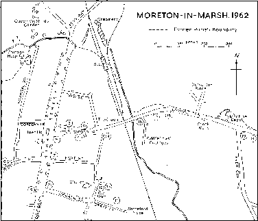
Moreton-in-Marsh, 1962
1. Curfew Tower
2. The Mann Institute
3. Congregational chapel
4. Lemington House
5. White Hart Hotel
6. Redesdale Arms Hotel
7. The Steps
8. Rectory
9. Fossway Hall
10. Manor House Hotel
11. St. George's Hall
12. St. David's House
13. Junior school
14. Secondary modern school
15. Infants' school
16. Gas works
17. Graveyard
18. Laundry
19. Wellington Inn
20. Wellington Villas
In the 20th century the town expanded eastwards and southwards. About 30 council houses were built in Wellington Road, off Evenlode Road, in 1926, and in 1932 a few more were built in Evenlode Road. About the same time the town was extended beyond Church Street by the building of some 20 council houses, called Warneford Place. In the mid-1930's council houses were built in London Road and in Dulverton Place off London Road. Redesdale Place Estate including c. 60 houses was built off the west side of the Foss Way, south of the former limit of the town, in 1937, and another 20 houses had been added by 1962. Between 1950 and 1955 Stockwells, an estate of c. 40 houses off the south side of London Road, and more council houses on Evenlode Road were built. Old people's dwellings were built on the west side of the Foss Way in 1957 (fn. 32) and in 1962 a block of old people's flats was under construction on the east side of the same road, where also a private housing estate had been recently completed. (fn. 33)
Outside the town are three farms. In 1962 Coldicote Farm (mentioned above) included a stone-built farm-house of the early 19th century, and two cottages built in 1889. (fn. 34) Dunstall Farm, south of the town, was probably built in the 17th century, and in the south-west part of the parish Upper Fields Farm was built by 1824. (fn. 35)
The Foss Way was called Stow Highway by the people of Moreton in the 17th century. (fn. 36) The course of the road south of the town may have been altered slightly and a track running from the south end of Moreton west of the Foss Way was in 1818 still called Old Foss Way. (fn. 37) The Foss Way was turnpiked in 1755. (fn. 38) The road crossing Moreton from east to west, entering the parish at the Four Shire Stone, was turnpiked in 1731 as part of the London to Worcester road; (fn. 39) it was known as London Highway in 1630. (fn. 40) A road to Batsford from the north end of Moreton existed in 1494 (fn. 41) and was turnpiked by 1823. (fn. 42) A road ran from the Chipping Norton road to Evenlode by 1821. (fn. 43) A bridge called Kyte Bridge in the early 15th century (fn. 44) may have been the one at the northern end of the town on the Foss Way; on the same road at the southern boundary of the parish Stow Bridge was made by the 17th century. (fn. 45) The bridge on the Evenlode road at the parish boundary was built by 1821. (fn. 46)
In 1826 a horse-drawn tramway was opened between Moreton-in-Marsh and Stratford-upon-Avon, with a branch to Shipston-on-Stour (Warws.). Its main purpose was to take agricultural produce from Moreton and the surrounding district and to bring coal to Moreton, (fn. 47) and it was intended to form a link with the Stratford-upon-Avon Canal. (fn. 48) From 1845 the tramway was leased to the Oxford, Worcester and Wolverhampton Railway, and was altered in 1853, when the main railway through Moreton was opened, to take coaches and trucks from the main line. Passenger traffic ceased in 1859 (fn. 49) but the line remained open until 1881. (fn. 50) In 1889 the track from Moreton to Shipston was converted for use as a steam tramway. (fn. 51) In the late 1950's this line, which had been closed to passenger traffic for some time, was closed to goods traffic also. (fn. 52) Moreton Junction, a main-line station on the Oxford, Worcester and Wolverhampton Railway, was opened in 1853, (fn. 53) and in 1962 it had a frequent service to London and Worcester.
The population of Moreton probably increased in the 13th century after the grant of a market and fair, but only 12 people were assessed for tax in 1327 at a figure which was less than half that of Bourton-onthe-Hill. (fn. 54) There were said to be 100 communicants in 1551. (fn. 55) In 1608 44 adult males were recorded (fn. 56) and by 1672 there were 108 households. (fn. 57) There was an increase in the population during the 18th century (fn. 58) and a rapid rise between 1801 and 1851, when the population was 1,512. The population declined slightly in the later 19th century and up to 1931; the figure in 1951, 1,798, (fn. 59) was swollen by the R.A.F. station, but during the 1960's the population continued to increase and was c. 2,000 in 1962.
Moreton had a good supply of water from wells sunk through the boulder clay to the glacial gravel, (fn. 60) and by the 19th century many houses had their own wells. (fn. 61) By the early 20th century, however, the water from most of the wells was polluted and considerable attention was given to the problem of finding a suitable water supply for the town. (fn. 62) By 1912 main water was supplied by the Campden Rural District from a source in Upper Swell, (fn. 63) and later Moreton was included in the North Cotswold Rural District scheme supplied from Donnington reservoir. (fn. 64) A main sewage disposal system and outfall works, south of the London Road on the east side of the parish, was built c. 1904 and later improved and extended. (fn. 65)
The Moreton Gas Company was formed by 1846 (fn. 66) and the gasworks were built in London Road immediately east of the railway. After nationalization Moreton gasworks continued in use for some years but by 1962 the gas supply came from Cheltenham. (fn. 67) Main electricity was available c. 1929. (fn. 68) A post office was established in Moreton by 1856, (fn. 69) and in 1933 a new post office was built on New Street. By 1948 the post office, which had been a head office, had become a sub-office under Evesham. (fn. 70) Moreton Fire Brigade was established by 1897 when a fire station was built. (fn. 71) A new fire station was built in 1923 on the east side of High Street, (fn. 72) on the site of the former parish pound, (fn. 73) and was later replaced by a larger building at the north end of the town.
The Moreton Cottage Hospital was built by private subscription in 1873 on land given by Lord Redesdale at the north end of the town in Back Ends. The first small stone building had seven beds, but in 1879 it was extended (fn. 74) following a bequest by Dr. William Sands Cox, the founder of Queen's College, Birmingham, of £3,000 in 1875. (fn. 75) The Joseph Phipps charity by will of 1886 gave a further £1,000 stock to the hospital (fn. 76) and an operating theatre was built in 1900. (fn. 77) Further extensions took place in 1919, when Mrs. G. Phipps Lockhart bequeathed £2,000 to the hospital, (fn. 78) in 1925, and in 1935. The hospital, which had been managed by trustees, (fn. 79) came under the Banbury and District Hospital Management Committee after 1946. (fn. 80)
In 1785 a friendly society was formed in Moreton, meeting at the Bear Inn, (fn. 81) and by 1815 196 people in the parish belonged to friendly societies. (fn. 82) The Moreton New Union Club was formed in 1825 and the Moreton Friendly Society in 1836. (fn. 83) By 1875 a branch of the International Order of Oddfellows had been formed in Moreton; (fn. 84) its strength in the late 19th century and early 20th is indicated by the fact that nearly all the houses built in Moreton during that period were built by the Oddfellows. The society owned c. 60 houses, some of which had been sold by 1962 when the society was still active in Moreton.
A branch of the British Legion was formed in 1922; (fn. 85) the Territorial Army had premises in Moreton from 1939 which in 1960 were taken over by the Civil Defence. (fn. 86) In 1856 Moreton had a reading room, a Philharmonic Society, and two cricket clubs, (fn. 87) and in 1962 sports clubs included cricket, football, and hockey clubs. A cinema was opened by 1923 (fn. 88) and closed c. 1960.
In 1891 the Mann Institute was built by Miss Edith Mann, in memory of her father, Dr. John Mann (son of the first Congregational minister), as a working men's club. (fn. 89) The institute was endowed by Miss Mann by will proved in 1902, and in 1903 a Scheme was drawn up for its administration by trustees including the rector and the Congregational minister. The site was conveyed to the trustees by Miss Elizabeth Mann in 1904. The Mann Institute included a hall, reading room, and recreation rooms and a flat for the use of women and children from the Canning Town Settlement (London) for holidays. (fn. 90) In 1962 the Mann Institute was in use also as a men's club.
A town hall, built in 1887 by A. B. FreemanMitford (fn. 91) and known as the Redesdale Hall, stands in the middle of High Street. The building, which is of stone, may be on the site of the former market hall; the lower part of the new hall which was left open, (fn. 92) giving the appearance of a market although it was not used as such, was filled in in 1951. (fn. 93) The Redesdale Hall was given by Lord Dulverton to the Rural District Council in 1951. (fn. 94)
The older buildings in Moreton are of stone, and almost all the buildings in High Street are of stone or stone-faced, though many have been re-roofed with Welsh slates or tiles. High Street and the streets leading off it include a number of 17th-, 18th-, and 19th-century houses with dormers, mullioned windows, and dripmoulds, but, particularly in High Street, many houses have been altered by the addition of bay windows and shopfronts. University Farm, with mullioned windows and hoodmoulds, has a doorway with an enriched frieze and the date 1678. Most of the larger houses are 18th-century ashlar buildings with moulded stone architraves and, in some cases, balustraded parapets. In High Street the house called the Steps, a large mid-18th-century ashlar house, has modillion cornices and a balustraded parapet; the doorway, with moulded architrave and pediment, is approached by a double flight of steps and is flanked by Venetian windows with semicircular three-light windows above them. The gableends have curvilinear parapets, and the frontage of the house is extended by outbuildings on each side. St. David's House, an 18th-century house in Church Street, stands in a row which includes a 17th-century house. It has a Cotswold stone roof with moulded stone eaves cornice, stone pilasters, and a doorway and windows with moulded architraves and triple keystones. The house is close to St. David's Well which was considered to be a holy well and was used for curing sore eyes. (fn. 95) In Oxford Street the large house called Lemington House has a gable and chimney stack which are said to be of the 16th century, but the house was altered and enlarged in the 18th century.
Since the late 19th century other building materials apart from stone have been used in Moreton, particularly brick which was used almost exclusively in the late 19th century and early 20th. On the early council estates, which were built on a uniform plan consisting of one main street with a short street running off each side, the houses were of red brick. In the mid-20th century a group of council houses, called Cornish-Unit houses, was built partly of wood, and others were made of re-constituted stone as were most of the private houses built at that time.
Of the public buildings, the oldest (and probably the oldest building in the town) is the Curfew Tower standing in High Street on the corner of Oxford Street. The building, which is of stone with a stone roof and a gabled turret and has a four-centred arched stone doorway, was probably built in the 16th century. The tower has a clock which is dated 1648 and a bell dated 1633 which was rung daily until 1860. An inscription on the tower, which was no longer visible in 1962, recorded a gift of 10s. for a bellringer and 20s. for keeping the clock in repair given in the 17th century by Robert Fry. (fn. 96) The Curfew Tower is said to have been used as a lock-up. (fn. 97) An ancient cross with a base of seven steps and a rectangular finial surmounted by a ball stood at the foot of the tower in the late 18th century. (fn. 98) It may have been the market cross which is said to have stood in the middle of the wide street, where the Redesdale Hall was later built, from the 13th century. (fn. 99)
During the 14th and 15th centuries Moreton had a large number of ale-sellers, (fn. 100) and in 1494 a large house on the Foss Way was called New Inn. (fn. 101) Of the two inns in Moreton in 1608 (fn. 102) one was the 'White Hart' on the south corner of Oxford Street. There is an unsubstantiated tradition that Charles I stayed at the 'White Hart' in 1644 on his way to Evesham. (fn. 103) The inn, which has been considerably extended and rebuilt, retained a small part of the 16th-century building in 1962 when it was still called the White Hart Hotel. The other inn in 1608 was the one held by Anthony Nicholls, called Bury's Inn in 1628 when it was owned by William Bury. (fn. 104) The inn called the 'Bear' on the east side of High Street existed by 1746. (fn. 105) The number of inns increased considerably during the 17th and 18th centuries, and in 1755 Moreton had 16 licensed victuallers. (fn. 106) An inn called the 'George' in 1738 (fn. 107) had closed by 1774, by which year the Bell Inn, on the west side of High Street, was opened. (fn. 108) Also on the west side of High Street, the 'Unicorn', called the 'Redesdale Arms' by 1891, (fn. 109) was one of the principal inns (with the 'White Hart') in the late 18th century (fn. 110) and is a building of that date. The Swan Inn on the corner of Bourton Road was opened by 1842. (fn. 111) Several other inns existed during the 19th century, perhaps for short periods only; during the first half of the 20th century 11 inns closed (fn. 112) and in 1962 Moreton had eight hotels and inns. At that time the largest hotel in Moreton was the 'Manor House' which became a hotel in the 1950's. The central part of the building, which is dated 1668 but probably incorporates part of an earlier building, is traditionally associated with the Creswyke family, which became one of the principal landowners in Moreton in the 17th century, (fn. 113) and the house has consequently been erroneously regarded as the manor-house. If the house was the one owned by the Creswyke family, it is possible that it was the house called Bury's Inn mentioned above, which was conveyed to Francis Creswyke in 1628. (fn. 114) Alterations were made in the 18th century on the north side, and extensions in the 19th century on the east side, and in the 1960's on the south side.
Whether or not the tradition that Charles I stayed at Moreton is true, the Royalist army passed through the town in 1644; (fn. 115) and it is said that Oliver Cromwell stayed at Moreton in 1651. (fn. 116) Edward VII visited Moreton in 1905. (fn. 117) Among the people of more than local fame who have been associated with Moreton are two of the town's benefactors, Dr. Samuel Wilson Warneford (fn. 118) and William Sands Cox. (fn. 119) John Sankey, the Lord Chancellor, created Viscount Sankey (d. 1948), was born in Moreton in 1866 and is buried there. (fn. 120)
Manor and Other Estates.
The estate in Moreton held of Westminster Abbey by Elfrid, a radknight, in 1066 and 1086, (fn. 121) became part of the abbey's manor of Bourton-on-the-Hill. (fn. 122) The estate was occasionally referred to as the manor of MORETON (fn. 123) though it was apparently never a separate manor but part of the manor of BOURTON AND MORETON. (fn. 124)
A small amount of land in Moreton-in-Marsh belonged to the Stonor family's manor of Bourtonon-the-Hill. (fn. 125)
By the early 17th century an estate of three yardlands in Moreton belonged to Oxford University for the maintenance of two mathematics scholars, and later for the maintenance of the Savilian professorship. (fn. 126) The estate was known as College farm in 1885 and University farm by 1902. (fn. 127) Between 1951 and 1955 the estate of c. 75 a. was divided and sold off in small pieces. (fn. 128)
A messuage in Moreton, said to have been given to the priests in the churches of All Saints and St. Helen in Worcester, presumably belonged to a chantry and was granted by the Crown in 1549. (fn. 129) A small portion of the tithes of Moreton, called board tithes, belonging to Tewkesbury Abbey until the Dissolution, were granted by the Crown in 1560. (fn. 130) Lord Redesdale, the owner in 1821, received an allotment of 3 a. for these tithes at inclosure. (fn. 131)
Markets And Fairs.
In 1226 the Abbot of Westminster was granted a weekly market in Moreton, (fn. 132) and in 1253 a yearly fair for six days from 20 to 25 September was also granted. (fn. 133) The market and fair were confirmed in 1280, on condition that they were not injurious to the neighbouring markets and fairs. (fn. 134) By the 16th century they had perhaps lapsed and were not granted with the manor.
In 1637 the Crown granted a weekly market and two annual fairs to Anthony Bouchier, (fn. 135) but the market had lapsed by 1675 and the fairs by the late 18th century. (fn. 136) In the mid-19th century when a market and fairs were again held they belonged to the lord of the manor. (fn. 137) In 1856 a weekly market, a monthly cattle fair, and two annual fairs were held. (fn. 138) When the manor was sold in 1919 the market and fair rights were bought by the auctioneers, Messrs. Bosley and Harper of Shipston. (fn. 139) The market continued to be held until c. 1935, (fn. 140) and the auctioneers allowed the parish council to hold an annual pleasure fair in September, which was still held in 1962. (fn. 141)
Economic History.
The land of Westminster Abbey in Moreton recorded in 1086 was assessed at only half a hide which was held by a radknight, but the ten hides of the abbey in Bourton-on-the-Hill (fn. 142) may have included part of Moreton also. Apart from a small part of Moreton which belonged to the other manor in Bourton-on-the-Hill, (fn. 143) the whole of the parish belonged to Westminster's manor of Bourton and Moreton during the Middle Ages. (fn. 144)
The demesne, which was managed by a bailiff in the 13th century (fn. 145) and was usually leased from the late 14th century, (fn. 146) included some arable in Moreton and three pastures called Ladymead, Myland, and Berrygore. Until the early 16th century the pasture was retained by the abbot for his sheep in winter, (fn. 147) but by 1519 the pasture was leased with the rest of the demesne. (fn. 148) In 1501 part of the demesne in Moreton was held by three customary tenants. (fn. 149)
A free tenement in Coldicote was probably held in the 13th century by the family called Coldicote, (fn. 150) and the rent paid by Nicholas Coldicote suggests that it was a substantial holding. (fn. 151) Another free tenant, who granted his rights in Moreton to the abbot between 1222 and 1246, (fn. 152) probably held the land which Margaret de Cormeilles was said to hold with her land in Batsford as a knight's fee in 1236. (fn. 153) A free tenant granted his land in Moreton to Westminster Abbey between 1258 and 1283, (fn. 154) and during the 14th and 15th centuries also there was a number of free tenants in Moreton. (fn. 155) In 1493 two free tenants were recorded. (fn. 156) In the early 14th century and presumably earlier, free tenants owed service of ploughing and carrying hay. The tenant of Coldicote owed six days' ploughing, (fn. 157) and in 1461 a free tenant of 2½ messuages and 2⅓ yardlands owed one day's hay-making and three boon-works. (fn. 158)
Of the 12 people assessed for tax in 1327 (fn. 159) most were probably customary tenants, and in 1542 the rent from customary tenants accounted for about two-thirds of the value of the manor. (fn. 160) Customary tenants owed heriots (fn. 161) and rents in money and kind. (fn. 162) In the 17th century it was said that the customs of the manor did not allow copyhold in reversion, (fn. 163) but widows were entitled to freebench. (fn. 164) Labour-services included ploughing, hay-making, winter sowing, and boon-works at harvest. (fn. 165) In 1314 some labour-service was sold (fn. 166) and by the late 14th century the service at winter sowing had been remitted. (fn. 167) In the early 16th century, however, customary tenants still owed some labour-service. (fn. 168)
A third kind of tenure in Moreton, and perhaps the most common, was that of the burgage-holders. The term burgage seems to have been used of the houses in the new town (fn. 169) which did not include any land. A distinction was drawn between landholders and burgage-holders, (fn. 170) but several people held both land and burgages. (fn. 171) The frequent references to burgageholders in the 15th and 16th centuries suggests a large number of them; in the mid-16th century there was a separate rent-collector for burgage rents though the amount collected was small. (fn. 172) Burgageholders were free tenants whose burgages passed by hereditary succession and who paid reliefs on admission. (fn. 173) In 1476 William Palmer was allowed to grant his burgage to an under-tenant. (fn. 174)
The land in Moreton belonging to the Stonors' manor of Bourton-on-the-Hill comprised a free tenement of a messuage and a close of land. (fn. 175)
In spite of its close association with Bourton-onthe-Hill, Moreton had its own open fields; Upper field lay south-west of the town and Lower field to the east. (fn. 176) In addition to the common meadow and pasture in leys in the open fields, (fn. 177) Moreton Heath or Common on the east side of the parish included a large area of pasture, (fn. 178) and on the west side of the parish where the demesne pasture lay there was also common pasture. (fn. 179) Land in the open fields was divided into lands or ridges, (fn. 180) and a yardland included c. 12 statute acres. (fn. 181) In 1542 landholders were allowed to keep only 20 sheep in the fields, (fn. 182) presumably for every yardland, but the proportion of sheep-pastures on Moreton Heath may have been higher; c. 1586 105 sheep-pastures were granted with a quarter yardland. Burgage-holders without land were not allowed to keep horses in the fields, (fn. 183) nor cows from February to September, and were allowed two cows or a cow and a horse on the Heath (fn. 184) for every burgage. For the purpose of poor-rates 20 burgages were taken as equal to a yardland, (fn. 185) and the proportion of pastures may have been the same. By the 17th century the term burgage was often applied to the cow-commons themselves rather than to the houses to which they belonged. (fn. 186) In the 16th century burgage-holders were allowed to keep seven pigs; (fn. 187) they were not then allowed to cut furze on the common, (fn. 188) though in the 17th century they had a right to part of the common furze in proportion to their cowcommons. (fn. 189) A hayward and an overseer of beasts were appointed in the 15th century, (fn. 190) and in 1543 four people were acting as overseers of beasts. (fn. 191)
By the 15th century some arable and meadow was held in severalty. (fn. 192) About 1630 the tenants of Moreton agreed to inclose some of the common and waste land without the consent of the lord of the manor. Some of the demesne was inclosed about the same time but in 1657 part of it was still uninclosed and was used at certain times of the year as common pasture by the tenants who had inclosed their land. (fn. 193) In 1768 there was still some open arable land, lying among the inclosures, held by tenants who had not agreed to the inclosure. (fn. 194) No evidence has been found of the extent of the land inclosed in the 17th century, which included part of the Upper field, (fn. 195) but by the time of the parliamentary inclosure in 1821 the parish included c. 600 a. of old inclosures. Most of the west side of the parish had been inclosed by that time and the only large area of common was Moreton Heath. (fn. 196)
From the large amount of pasture in Moreton it is evident that sheep-farming was important. Apart from the demesne pasture, in the 16th century a large flock of sheep was kept by members of the Palmer family. (fn. 197) With inclosure there was probably an increase in pasture. Tobacco was grown in the parish in the early 17th century; (fn. 198) in the 18th century, in addition to oats, wheat, pulse, and barley, (fn. 199) flax was grown for the town's linen industry. (fn. 200) In 1801, when 215 a. were recorded as sown mainly with wheat, oats, and barley, it was said that the crops that year were much higher than the two previous crops; (fn. 201) in 1803 the parish was described as mainly pasture. (fn. 202)
By 1691 the demesne in Moreton was all meadow including Ladyham, Myland (which was c. 2 a.), Berrygore, 2 a. of common meadow, three closes of meadow, and another piece of meadow of 5 a. (fn. 203)
In 1617 the tenants of Moreton included copyholders, lease-holders, and tenants at will, (fn. 204) as well as freeholders and burgage-holders. The number of free tenants may have increased after the 17th-century inclosure, and by the end of the century a number of freeholders had large estates. Between 1616 and 1663 members of the Creswyke family bought several small freehold estates (fn. 205) and became one of the principal landowners in the parish. (fn. 206) In 1775 the Creswyke estate had the largest assessment for land-tax of the 33 estates assessed. (fn. 207) In 1819 Moreton included five copyhold and c. 50 freehold estates most of which, apart from Dunstall farm (a copyhold estate) and Coldicote farm (a freehold estate), consisted of cottages and cow-commons. (fn. 208)
The inclosure in 1821 dealt with 986 a. including c. 600 a. of old inclosures many of which were exchanged and re-allotted. Apart from the lord of the manor's allotment for manorial rights and the rector's allotment for tithes, 13 people received small allotments of previously uninclosed land, mostly on Moreton Heath. Four people had large estates of old inclosures, the largest, c. 260 a., being that of Sir Charles Cockerell, the owner of the former Creswyke estate. (fn. 209)
In 1848 there were still 17 copyhold estates in Moreton, held for terms of three lives. Heriots were payable in kind, and were normally the two best beasts; widows' rights of freebench persisted. The ten remaining copyholders were enfranchised in 1855. (fn. 210)
By 1854 871 a. in Moreton belonged to the Sezincote estate and was divided between three farmers and five cottagers. (fn. 211) In 1880 two farms belonging to the estate, Upper Fields and Dunstall, were c. 100 a. and 164 a. (fn. 212) respectively, the only other farms in the parish being Coldicote farm and University farm. In 1962 these four, ranging in size from c. 70 a. to c. 200 a., were the only farms in the parish. (fn. 213)
After inclosure farming continued to be mixed, with perhaps slightly more arable than pasture. (fn. 214) In 1935 apart from small areas of arable around the farm-houses the parish was nearly all meadow and pasture, with a number of allotments in the town. (fn. 215) Farming was mixed in 1962, with a predominance of arable at Dunstall farm and sheep at Coldicote farm. (fn. 216)
Little evidence has been found of the economic importance of the market and fairs in Moreton, and it seems that for long periods they were not held at all. (fn. 217) It was said c. 1700 that the market had been much frequented in times of plague in the larger market towns. (fn. 218) In the 19th century the market was very small until the opening of the railway, which helped to make Moreton a minor commercial centre in the later 19th century. (fn. 219) If the market was not very important, however, the position of Moreton on a main road and later at the junction of two turnpike roads meant that it always had a number of traders. In addition to the ale-sellers in the 15th and 16th centuries there are frequent references to butchers (fn. 220) and in 1545 Westminster Abbey leased its bakeries. (fn. 221) In 1608 Moreton had a barber, a chandler, and three butchers (fn. 222) and throughout the 17th, 18th, and 19th centuries frequent references occur to various traders and to shops. (fn. 223) By the late 19th century Moreton had a number of branch banks and insurance offices. (fn. 224) By the 20th century most of the houses in High Street were shop premises, and Moreton served as a regional shopping centre.
Moreton has had a number of craftsmen connected with agriculture. In 1608 there were three smiths, three carpenters, and a collarmaker, (fn. 225) and in the 18th and 19th centuries also the parish usually had smiths, carpenters, wheelwrights, and saddlers. (fn. 226) In 1962 a few blacksmiths were still employed in the parish, mainly in repairing agricultural machinery. In 1497 Richard Palmer had a woolhouse in Moreton, which his son Robert Palmer had in 1534. (fn. 227) There was a weaver and a dyer in 1608, (fn. 228) and in 1652 and 1669 also there were weavers. (fn. 229) A woolstapler was living in Moreton in 1796 (fn. 230) and another in 1870; (fn. 231) the town usually had a number of tailors. (fn. 232) Mercers were living in the parish in 1608, (fn. 233) the mid-17th century, (fn. 234) and 1705. (fn. 235) In 1742 a linen factory was established in Church Street; it is thought to have employed c. 40 people at one time, (fn. 236) and in 1803 many of the poor were engaged in spinning linen yarn in their homes. (fn. 237) There was a flax dealer in Moreton in 1805 (fn. 238) and a flax shop in 1819. (fn. 239) The linen industry, which had begun to decline by the mid-19th century, was still operating in 1867 but had stopped before 1900. (fn. 240) There was a hemp-dresser in Moreton in 1652, (fn. 241) and by the late 19th century a small rope-making industry had been established in the town. The industry was flourishing in the early 20th century but had stopped by 1952 when the premises were used for sewing tarpaulin sheets. (fn. 242) Shoemaking was carried on in Moreton from the 17th century; two shoemakers were recorded in 1608, (fn. 243) and the town had a number of shoemakers later in the century and in the 18th (fn. 244) and 19th centuries. (fn. 245) Other craftsmen in Moreton include two masons in 1608, (fn. 246) masons and slaters in the mid17th century, (fn. 247) and builders, plumbers, and plasterers in the 19th century; (fn. 248) a glover and a cooper in 1655, a barber in 1648, and a gunsmith in 1664. (fn. 249) There was a mineral-water manufacturer in 1889. In 1858 a printing works was established which produced a weekly newspaper, the Moreton Free Press, until c. 1895. (fn. 250)
From the mid-19th century important sources of employment have been the railway and the gas company, and a dairy, a laundry, and an iron foundry. The dairy, started in 1889, changed hands several times before it was taken over in 1937 by United Dairies Ltd., which owned it in 1962. The Progressive Laundry, opened in 1899 in London Road, employed c. 30 people. The Britannia Works was opened as a small foundry near the railway; (fn. 251) it had expanded and moved to London Road by 1922. (fn. 252) At one time it employed c. 30 men, engaged mainly in the manufacture of steel window-frames. (fn. 253) In 1962 the premises were used as a depot for milkingmachines, and there were a few other small workshops in London Road.
In the mid-20th century the growing tourist industry brought to Moreton a number of petrolstations and shops, which, with the few small industries, provided employment for some of the population, while a similar proportion was employed outside the parish in Stratford, Oxford, and Cheltenham. In 1962 Moreton had a number of doctors, dentists, and other professional people.
Mill.
In 1470 John Mayhew held a mill which in 1475 was described as a hand mill called 'le overne'. (fn. 254) It may have been the same mill that was held by Richard Mayhew in 1493, but it was then called a water-mill. (fn. 255) No other evidence of a mill at Moreton has been found.
Local Government.
Moreton-in-Marsh was the centre of the Abbot of Westminster's leet jurisdiction in the Upper Division of Westminster hundred, and view of frankpledge there was attended by the vills of Todenham, Sutton, and Bourton as well as Moreton itself. (fn. 256) By 1273 a single court, which seems to have been held normally four times a year, included both the view of frankpledge and the court, called the portmote, (fn. 257) by which the town was governed. At the Dissolution view of frankpledge was granted with the manor of Bourton and Moreton; the court, then held twice a year (fn. 258) and usually described as view and court, (fn. 259) and later as court leet and baron, was held by the lessees of the manor at least until the end of the 18th century. (fn. 260) Court rolls survive for 1376–7, 1402, 1462–1545 with gaps, 1661, and 1670–88. (fn. 261)
In the 15th century an officer for Moreton called the catchpole was elected by the court and performed the functions of tithingman. (fn. 262) Two catchpoles were elected in 1470, (fn. 263) and in 1477 a tithingman was elected as well as the catchpole, and a bailiff of the town was also elected at that time. (fn. 264) From the early 16th century two sergeants were appointed, apparently to take the place of the tithingman and catchpole, (fn. 265) and in the 17th century Moreton had two tithingmen. (fn. 266) From 1470 a constable was appointed in addition to the officers already mentioned; (fn. 267) Moreton had two constables in the 18th century. (fn. 268) There were two ale-tasters from 1473 until the mid-16th century. (fn. 269)
In 1637 a 'pie powder' court was granted to Anthony Bouchier with the market and fairs, (fn. 270) but no record of its activity has been found.
Although Moreton was a chapelry of Bourton-onthe-Hill it had its own churchwardens by the 16th century, (fn. 271) and its own overseers by the 17th century. In 1662, after the passing of the Act of Settlement, the landholders and burgage-holders of Moreton undertook not to bring to live in the town, without security, any stranger who might become a charge on the parish. The burgage-holders bound themselves to this agreement in bonds of £20, in return for which they were exempted from poor-rates. (fn. 272) Expenditure on poor relief increased almost fivefold, to £468 a year, between 1776 and 1803, when 44 parishioners received regular relief and 13 occasional relief. Twenty-four children were in a school of industry in 1803; and relief was given to 631 people who were not parishioners. (fn. 273) In the next ten years expenditure on relief doubled, but by 1815 it had decreased again. By that time Moreton had a workhouse in which eight people were relieved; another 56 had regular relief outside the workhouse, and ten received occasional relief. (fn. 274) By 1834 expenditure had decreased again, to £430. (fn. 275)
Under the Act of 1834 Moreton became part of the Shipston-on-Stour Poor Law Union, and part of the Shipston Rural Sanitary District in 1872, becoming part of the Campden Rural District in 1894. In 1935 Moreton became part of the new North Cotswold Rural District, (fn. 276) and the council offices were established in Moreton. The parish council met regularly in 1962.
Church.
No evidence has been found to support the tradition that the foundations of a building, thought to be of the 12th century and uncovered in the late 19th century, indicate a former site of the church in Moreton. (fn. 277) The position of the existing church, in the old town, argues in favour of an early foundation of the church on that site. By 1295 there was a graveyard in Moreton (fn. 278) and therefore, presumably, a church; the absence from medieval documents of any reference to the church may be explained by the fact that it was a chapel of ease to Bourton-on-the-Hill. (fn. 279) With Bourton, Moreton was in the peculiar of Blockley (fn. 280) and the parishioners of Moreton buried at Blockley until 1512 when they were allowed to bury in the churchyard of Moreton. Mortuaries, however, continued to be paid to the Vicar of Blockley (fn. 281) until the 19th century. (fn. 282) Moreton chapel was used for baptisms and marriages by 1643 and 1673 respectively. (fn. 283)
A chaplain, described as the parish priest in 1406, (fn. 284) was presumably appointed by the Rector of Bourtonon-the-Hill in the Middle Ages; and in 1540 the parish was served by a stipendiary curate paid by Richard Palmer of Bourton. (fn. 285) During the 17th, 18th, and 19th centuries the parish was usually served by a stipendiary curate who was nominated by the Rector of Bourton-on-the-Hill, (fn. 286) who at one time in the early 17th century gave the tithes of the demesne in Moreton to the curate for his stipend. (fn. 287) In 1887 Moreton was separated from Bourton and annexed to Batsford. The patron of the rectory of Batsford with Moreton (fn. 288) in 1887 was A. B. Freeman-Mitford, later Lord Redesdale; in 1922 the advowson was sold with the Batsford estate to Lord Dulverton (fn. 289) whose son, Lord Dulverton, was patron in 1962. (fn. 290)
The great and small tithes, except for a small portion called board tithes, (fn. 291) belonged to the Rector of Bourton-on-the-Hill and were said to be worth £40 in 1650. (fn. 292) By 1704 a corn-rent of £53 was paid for tithes, (fn. 293) and at inclosure in 1821 the Rector of Bourton received c. 200 a. for land and tithes in Moreton. (fn. 294) At the inclosure in the early 17th century land worth c. £4 was allotted to the church, (fn. 295) but it had been lost by 1807. (fn. 296) In the late 19th century the rectory house in Batsford was exchanged for a house in Moreton. (fn. 297)
In 1551 the curate of Moreton was found satisfactory in learning; (fn. 298) in 1584 when there was no curate the parish was served by the rector, who lived at Bourton. (fn. 299) Some of the curates served the parish for long periods; (fn. 300) in the mid-18th century there were 'full services', and in the early 19th century, when two services were held each Sunday, there was vocal and instrumental music. (fn. 301) The curate's stipend was £30 in the 18th century (fn. 302) and had risen to £100 by the mid19th century. (fn. 303) A house next to the church, still known as the Old Parsonage in 1962, is said to be the house where the curate lived. After 1887 the rector lived in Moreton and the parish had a resident curate also, (fn. 304) but by 1962 when the congregations numbered c. 100 there was no curate.
A close said to have been given to pay a bell-ringer (fn. 305) but used in 1704 for repairing the church (fn. 306) had been lost by 1807. (fn. 307)
The church of ST. DAVID, a large, mainly 19thcentury building of stone with a tiled roof, comprises nave of five bays, chancel, north and south aisles and south chapel, west tower in three stages with a spire, and vestry. Some fragments of 13th-century windows and gargoyles incorporated into other buildings in Moreton are thought to have come from the church, (fn. 308) as is part of a stone screen in the church at Bourtonon-the-Hill. In the 16th century a small embattled tower was built and possibly the whole church was rebuilt at that time as there was a tradition that the church was consecrated in the mid-16th century. (fn. 309) The building, which included a north aisle in the 17th century, (fn. 310) was too small for its congregation by 1790 and in that year the nave was enlarged, the roof raised, and a new entrance made under the tower at the west end at the expense of Thomas Freeman of Batsford. (fn. 311) In 1858 most of the church was rebuilt largely in the style of the 13th and 14th centuries, and a few years later the 16th-century tower was replaced by a large embattled and pinnacled tower with a high octagonal stone spire. The chancel and south aisle were enlarged, and the galleries in the north aisle removed, in 1892 with money given by the rector, Spencer Jones, for that purpose; (fn. 312) in 1927 the east end of the south aisle began to be used as a chapel. (fn. 313) An octagonal font, possibly of the 15th century, which stood in the church in the 19th century, (fn. 314) had been removed by 1962.
Three of the bells are of the 17th century, one of 1735, and four of 1862. (fn. 315) The church plate is all of the 19th century except a chalice and paten cover dated 1576. (fn. 316) The registers of baptisms and burials start in 1643 and the registers of marriages in 1672, and are virtually complete.
Roman Catholicism.
There may have been Roman Catholics at Moreton in 1593, for in that year a Roman Catholic priest was arrested there. (fn. 317) Two Roman Catholics were recorded at Moreton in the early 18th century. (fn. 318)
By 1948, when Moreton was served from Chipping Campden Roman Catholic Church, services were held in the Y.M.C.A. hall; in 1950 a temporary church in Bourton Road was in use. Services were later held in a private house until 1956 when St. George's Hall, a small stone building off Church Street, was opened. (fn. 319)
Protestant Nonconformity.
By the mid-17th century there was a Baptist community at Moreton, (fn. 320) and in 1676 20 nonconformists were enumerated at Moreton and Bourton-on-the-Hill. (fn. 321) Ten people in Moreton were said to be Anabaptists in 1735, (fn. 322) and there was a family of Independents in 1743. (fn. 323) Protestant dissenters were meeting in private houses in 1831, 1836, and 1846, (fn. 324) and there were Baptists in Moreton in 1851. (fn. 325)
A group of nonconformists under the direction of John Mann, meeting in a barn from 1796, formally united as a Congregational church in 1801. A chapel, seating c. 300, was built in 1817 (fn. 326) on the north side of Oxford Street. By 1821 the chapel had its own burial ground; (fn. 327) the register of baptisms starts in 1840, and in 1841 the chapel was registered for marriages. (fn. 328) Two services were held on Sundays in 1851 when the congregation was c. 275. (fn. 329) A new chapel, seating 450, was opened in 1861 on the site of the old one; (fn. 330) it has a symmetrical stone front with Grecian and Italianate detail. In 1907 an organ was installed and in 1918 the chapel was extended by the addition of a hall and a vestry built in memory of John Mann over his grave. Although there had been a resident minister since 1796 the chapel did not own a manse until 1924 when a house adjacent to the chapel was bought. (fn. 331) In 1961 Moreton Congregational church had a total membership of 70 including ten lay preachers. (fn. 332)
Edith Mann's charity in memory of her father, Dr. John Mann, founded by will proved in 1902, provided for an annual sermon for the Congregational church. In 1941 the income from the charity was £26. (fn. 333)
A meeting of the 'Open' Brethren was begun in 1932, and in 1948 a small hall was built, south of the town on the main road, known as the Fossway Hall. In 1962, when the congregation numbered c. 26, meetings were held every Sunday. (fn. 334)
Schools.
A school in Moreton opened by the early 19th century (fn. 335) was in 1813 replaced by a Church of England school built and endowed by Lord Redesdale and the rector, Samuel Wilson Warneford. It comprised two separate stone buildings with teachers' houses, close to the east end of the churchyard. By 1853, when the average attendance was 75 boys and 65 girls, the teachers were certificated, (fn. 336) and the school received an annual grant from 1856. (fn. 337) The buildings had been enlarged by 1892 and the average attendance was 225. (fn. 338) In 1851 a Church of England infants' school was built and endowed by the Revd. Samuel Wilson Warneford. The school, a small stone building with a slate roof in Oxford Street, had c. 80 pupils in 1858. (fn. 339) It received further endowments in 1899 and 1900. (fn. 340) In 1904 the girls' and infants' schools formed two departments of one Church of England school, and the boys' National school became a council school. (fn. 341) After 1923 the girls' and infants' school had become a primary school of two departments, junior mixed and infants. (fn. 342) In 1962 the school, which had c. 80 infants and c. 150 junior pupils, was a controlled school. (fn. 343)
John Mann had established a school in Moreton before 1817, (fn. 344) and in 1845 a new building was provided by Thomas Horne for a British School for boys, girls, and infants. The building in Bourton Road, of stone with a stone roof, was enlarged in 1847 and 1851. The average attendance in 1854 was 110, and the school was financed by the parents and voluntary contributions. (fn. 345) From 1854 the school received an annual grant. (fn. 346) By 1903 attendance had fallen to 64, and the school was closed in 1907. (fn. 347)
In 1908, as a result of the closing of the British school, the council school in the premises of the former boys' National school became a mixed and infants' school. (fn. 348) It was reorganized in 1923 (fn. 349) as a senior mixed school, (fn. 350) later becoming a secondary modern school. The school was enlarged in 1936 and 1953, (fn. 351) and in 1962 had c. 500 pupils from Moreton and the surrounding villages.
Charities.
A number of small charities amounting to £60, given by an unnamed Rector of Batsford, William Sley of Moreton, Mrs. Joan Philips of London, and Samuel Creswyke of Moreton before the end of the 17th century, (fn. 352) had apparently been lost by 1828. (fn. 353)
A building known as the Pest House, said to have been built c. 1686 for poor people suffering from plague, was rented in the 19th century and the income used to buy coal for the poor. It was uninhabited and in a bad state of repair in 1884, (fn. 354) and had been pulled down by 1922. (fn. 355) The 12 a. allotted at inclosure in 1821 for fuel for the poor (fn. 356) was rented and the income used to buy coal. (fn. 357) In 1957 the accumulated income of £57 was used to buy coal. (fn. 358)
A gift of £43 stock by Thomas Simms in 1815 to provide blankets for seven poor families produced £7 7s. in 1828. (fn. 359) The John Shirley charity founded by will proved in 1859 and the John Shirley Hawkins charity by will proved in 1942 provided £100 and £134 stock respectively for blankets for the poor. Henrietta Hooper by deed of 1845 gave £200 stock (fn. 360) to provide 12s. each for ten poor widows for coal and clothing. (fn. 361) In 1957 the Simms and Hooper charities each produced £5 annually which was used to buy clothing, and the Shirley and Hawkins charities had in 1952 an accumulated income of £57 which was spent on blankets. (fn. 362)
In 1856 Harriet Warneford endowed the Gloucester Infirmary with £217 to provide free beds for the poor of Moreton in need of hospital treatment. In 1956 the capital was transferred to trustees for the benefit of the sick of Moreton. (fn. 363) The people of Moreton were eligible for the Redesdale charity founded by deed of 1856. (fn. 364)